Showing 9551 items
matching east street
-
 Bacchus Marsh & District Historical Society
Map, Gaynor Street Area Land Sales, Maddingley, 1888
... , Typpynge Street, Finn Street and East Maddingley Road. . The map... Street and East Maddingley Road. . The map is pasted ...This map was produced for a major sale of land in the Maddingley area of Bacchus Marsh in 1888. The sale was conducted by two firms from Melbourne, Carney and Kelly 12 Swanston Street Melbourne. and 'Richardson, Kerr & Co. 40 Flinders Lane Melbourne. 136 blocks were for sale.A single page paper map showing land allotments for sale in the Maddingley area of Bacchus Marsh. Locations shown include Gaynor Street, Maddingley Road South, Parwan Road, Mitchem Street, Typpynge Street, Finn Street and East Maddingley Road. . The map is pasted into a bound volume containing 76 maps or plans in total. High resolution digital image stored on BMDHS computer network. bacchus marsh victoria maps, maddingley victoria maps, land use, maddingley victoria history, land sales bacchus marsh, land sales maddingley -
 Bacchus Marsh & District Historical Society
Map, Gaynor Street Land Sales, Maddingley, circa 1880s-1890s
... , Typpynge Street, Finn Street and East Maddingley Road. . The map..., Typpynge Street, Finn Street and East Maddingley Road. . The map ...This map was produced for a major sale of land in the Maddingley area of Bacchus Marsh. The precise date of the sale has not been determined. Features present on the map such as the Bacchus Marsh Railway Station indicate the land sale must have taken place some time after 1887 when the Railway Station opened. A single page paper map showing land allotments for sale in the Maddingley area of Bacchus Marsh. Locations shown include Gaynor Street, Maddingley Road South, Parwan Road, Mitchem Street, Typpynge Street, Finn Street and East Maddingley Road. . The map is pasted into a bound volume containing 76 maps or plans in total. High resolution digital image stored on BMDHS computer network. bacchus marsh victoria maps, maddingley victoria maps, land use, maddingley victoria history, land sales bacchus marsh, land sales maddingley -
 Eltham District Historical Society Inc
Photograph - Aerial Photograph, Landata, Montmorency, Vic, Apr. 1972
... Road to east and Alban Street to west. Historic Aerial... Road to east and Alban Street to west. Historic Aerial ...Centred on present day Olympic Avenue at Grand Boulevard, Montmorency bounded by Meruka Drive to north, Main Road to south, Main Road to east and Alban Street to west. Historic Aerial Imagery Source: Landata.vic.gov.au Aerial Photo Details: Project No :985 Project : MELBOURNE 1972 Run : 28 Frame : 206 Date : 04/1972 Film Type : B/W Camera : RC10 Flying Height : 5700 Scale : 9600 Film Number : 2635 GDA2020 : 37°43'21"S, 145°07'46"E MGA2020 : 335154, 5823329 (55) Melways : 21 E7 (ed. 42)aerial photo, neil webster collection, 1972-04, eltham, alban street, grand boulevard, lower plenty, main road, melway 21e7, meruka drive, montmorency, olympic avenue -
 Eltham District Historical Society Inc
Photograph - Aerial Photograph, Landata, Eltham, Vic, Apr. 1972
... , Reynolds Road to east and Bible Street to west. Historic Aerial..., Reynolds Road to east and Bible Street to west. Historic Aerial ...Centred on present day Mays Road at Stringybark Road, Eltham bounded by Nyora Road to north, Yarra River to south, Reynolds Road to east and Bible Street to west. Historic Aerial Imagery Source: Landata.vic.gov.au Aerial Photo Details: Project No :985 Project : MELBOURNE 1972 Run : 28 Frame : 209 Date : 04/1972 Film Type : B/W Camera : RC10 Flying Height : 5700 Scale : 9600 Film Number : 2635 GDA2020 : 37°43'33"S, 145°09'28"E MGA2020 : 337647, 5823013 (55) Melways : 22 B8 (ed. 42)aerial photo, neil webster collection, 1972-04, eltham, bible street, mays road, melway 22b8, nyora road, reynolds road, stringybark road, yarra river -
 Ballarat Tramway Museum
Map, Electric Supply Co. of Vic (ESCo), Ballarat Electoral Map - ESCo, 1900
... parts of the City of Ballaarat, Sebastopol and Ballarat East..., Sebastopol and Ballarat East. Shows the street names, boundaries ...Document prepared by the Electric Supply Co of Victoria, as part of an order under the Electric Light and Power Act 1896, section 5 of order No. 17 granted to company. Dated 19/2/1901 and signed by the Postmaster-General. Shows the order area being parts of the City of Ballaarat, Sebastopol and Ballarat East. Shows the street names, boundaries, principal power line routes, land reserves, parks, mine locations, railways and Lake Wendouree. Signed by R L Williams Town Clerk City of Ballarat, J R Hall for the Borough of Sebastopol, and John Gent for the Town of Ballarat EastYields information about the power supply to the Ballarat area.Cloth backed paper map, coloured and marked up as exhibit 17.Notes in ink including the signature of Benjamin Deakin 24/9/00 and certified by the three involved municipal Town Clerks.ballarat power supply, esco, electric supply co of victoria, city of ballaarat, east ballarat, sebastopol, orders, power lines, power supply -
 Vision Australia
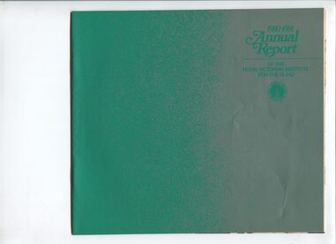
Administrative record - Text, Royal Victorian Institute for the Blind annual report 1980-1981, 1980-1981
... , a new Family Group home at Andrews Street, East Burwood, new..., a new Family Group home at Andrews Street, East Burwood, new ...Articles in annual report include: the development of an educational camp at Romsey through the bequest of Mrs Cecelia Tye, a new Family Group home at Andrews Street, East Burwood, new program developed for Trans Australia Airlines providing mobility instruction to air hostesses when guiding blind passengers, three kiosks at RMIT, Melbourne University and RVIB providing employment and training for blind workers, a short term contract assembling motorcycles, introduction of paperless Brailler (Digicasette), beginning of Il Globo becoming available as an audio magazine and provision of up to $3000 interest home loan for blind people. 1 volume of printed materialroyal victorian institute for the blind, corporation records -
 Eltham District Historical Society Inc
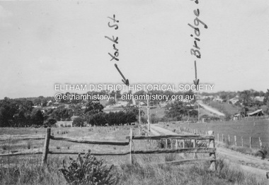
Album - Photograph, J.A. McDonald, Eltham-Diamond Creek Road, 21 Oct. 1953
... intersection of Silver Street at Brisbane Street looking east... intersection of Silver Street at Brisbane Street looking east ...Diamond Street Bridge 21st October, 1953 (showing York St., Bridge St., and Brisbane St in immediate foreground) View from intersection of Silver Street at Brisbane Street looking east. On the far side of Brisbane Street is the site of present-day Bunnings store. At the visible end of Brisbane Street where it turns right it then became Susan Street but today continues to the intersection with Bridge Street.Record of various Shire of Eltham infrastructure works undertaken during the period of 1952-1962 involving bridge and road reconstruction projects, sometimes with Eltham Shire Council Project Reference numbers quoted. It was during this period that a number of significant improvements were made to roads and new bridges constructed within the shire that remain in place as of present day (2022). In many situations, the photos provide a tangible visible record of infrastructure that existed throughout the early days of the Shire. The album was put together by or under the direction of the Shire Engineer, J.A. McDonald.infrastructure, road construction, shire of eltham, 1953-10-21, bridge construction, brisbane street, silver street, susan street, york street -
 Greensborough Historical Society
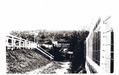
Photograph (copy), Plenty River Tea Gardens, 1929c
... Plenty River Tea Gardens were located on east side of Main... located on east side of Main Street near St Helena Road ...Plenty River Tea Gardens were located on east side of Main Street near St Helena Road intersection. [Ref: The Age 18/2/1929 page 3 - Greensborough - Comfortable Home. 6 rooms. large verandas. ½ acre. S O bungalow. Lovely spot. 4 minutes station. Furnished or unfurnished or will sell reasonable. River Plenty Tea Gardens. Phone Gr. 17]Two black & white photographsplenty river tea gardens, greensborough tea rooms -
 Melbourne Tram Museum
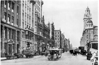
Photograph - Black and White - Flinders St looking east - 1915c
... Photo of Flinders St looking east from about Queen Street... Photo of Flinders St looking east from about Queen Street, c1915 ...Photo of Flinders St looking east from about Queen Street, c1915. Has many horse drawn vehicles and one cable tram with two ladies riding on the front of the grip car. In the view are Robert Reid & Co, Commerce House, Finks building and Flinders St Station. The station was completed in 1909. Commerce House or the Commercial Travellers Association building was completed in 1913 - see reference.Yields information about Flinders Street between Queen and Elizabeth Streets.Photograph - Black and White - Flinders St looking east - 1915c from near Queen Street.tramways, trams, cable cars, flinders street, commerce house, cta building, flinders street station -
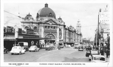 Melbourne Tram Museum
Postcard, Rose Stereograph Co, "Flinders St Railway station Melbourne", c1940
... the eastbound safety zone stop on the east side of Swanston Street. ... stop on the east side of Swanston Street. Yields information ...Rose Series postcard No. P 1060, titled "Flinders St Railway station Melbourne," shows a W2 with white war time paint on the bumper bar crossing Swanston Street (Route 28?) with many cars and one horse-drawn cart in the view. On the est bound safety zone stop are several men in military uniforms. Note the eastbound safety zone stop on the east side of Swanston Street. Yields information about the intersection of Flinders and Swanston Sts.Postcard - printed real photograph with Rose Stereograph Co. name on the rear.Has been used as a part letter to Ken Magor.trams, tramways, w2 class, flinders st station, flinders st, swanston st, safety zones, world war ii, princes bridge station -
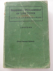 Warrnambool and District Historical Society Inc.
Book, Breeding & management of live stock, 1943
... was on the east side of Liebig Street between Lava and Koroit Streets... Street (south of Merri St) Warrnambool great-ocean-road This book ...This book has the stamp of ‘Ecker’s Hotel’. This hotel was on the east side of Liebig Street between Lava and Koroit Streets and was opened in 1875 by James Dooley. It was take over in 1885 by James Taylor and then by Joe Ecker in 1910. When Joe Ecker left the hotel in 1923 the licensees following retained the name ‘Ecker’s’. The hotel closed in 1962. It is the only hotel in Warrnambool to have had no other name except that of three of its owners. This book is only of interest because of its connection with Ecker’s Hotel, well-known in Warrnambool for 90 years as a comfortable, well-managed place to stay or visit. No doubt many of the clientele were farmers and this would explain the reason for the book being retained at the hotel. This is a hard cover book of 408 pages. It has a green cover with black lettering on the front cover and on the spine. It has a Preface, a Contents page, 25 chapters of Text, a Gestation Table and an Index. There are many black and white photographs and illustrations scattered throughout the text. The back page is torn and the cover is scuffed and the book is a little warped out of shape. There is some pencil scribble on the first page and a black-coloured stamp. ‘Ecker’s Hotel’ ecker’s hotel, warrnambool, joe ecker, warrnambool history -
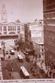 Melbourne Tram Museum
Slide - Black and white reproduction photograph - Elizabeth St Melbourne, 1920c
... /telephone line on the east side of the street. Original photo.../telephone line on the east side of the street. Original photo ...Photograph - looking south along Elizabeth Street Melbourne to towards Flinders Street station. Has three cable trams in the photo, including one shunting at the terminus. Has signs for the London Cafe and Federal Cafe in the view, along with many horse-drawn vehicles and a few motor cars. There is a telegraph/telephone line on the east side of the street. Original photo by Rose Stereograph Co. P 957 - see reference. Yields information about the south end of Elizabeth St and the cable tram terminus.Kodachrome cardboard duplicate slide - Black and white reproduction photograph - Elizabeth St c1920 "CB9" in penciltrams, tramways, cable trams, elizabeth street, flinders st station -
 Eltham District Historical Society Inc
Photograph - Aerial Photograph, Landata, Eltham North, Feb. 1956
... College to east and Leach Street to west. Historic Aerial... College to east and Leach Street to west. Historic Aerial ...Centred on present day 54 Kelway Crescent, Eltham North bounded by Glen Gully Road to north, Meruka Drive to south, Eltham College to east and Leach Street to west. Historic Aerial Imagery Source: Landata.vic.gov.au Aerial Photo Details: Project No :250 Project : MELBOURNE OUTER SUBURBS PROJECT Run : 17 Frame : 113 Date : 02/1956 Film Type : B/W Camera : EAG9 Flying Height : 10000 Scale : 12000 Film Number : 1176 GDA2020 : 37°42'16"S, 145°08'08"E MGA2020 : 335650, 5825336 (55) Melways : 21 G2 (ed. 42)aerial photo, 1956-02, eltham, eltham north, glen gully road, leach street, main road, melway 21g2, meruka drive, montmorency, neil webster collection -
 Eltham District Historical Society Inc
Photograph - Aerial Photograph, Landata, Montmorency, Feb. 1956
... Way to south, Main Road to east and Leach Street to west... Way to south, Main Road to east and Leach Street to west ...Centred on present day Tahlee Place Reserve and Sherbourne Preschool, Montmorency bounded by Progress Road to north, Withers Way to south, Main Road to east and Leach Street to west. Historic Aerial Imagery Source: Landata.vic.gov.au Aerial Photo Details: Project No :250 Project : MELBOURNE OUTER SUBURBS PROJECT Run : 17 Frame : 114 Date : 02/1956 Film Type : B/W Camera : EAG9 Flying Height : 10000 Scale : 12000 Film Number : 1176 GDA2020 : 37°42'50"S, 145°08'02"E MGA2020 : 335512, 5824286 (55) Melways : 21 F5 (ed. 42)aerial photo, 1956-02, neil webster collection, central park, eltham, leach street, main road, melway 21f5, montmorency, progress road, withers way, sherbourne preschool, tahlee place reserve -
 Eltham District Historical Society Inc
Photograph - Aerial Photograph, Landata, Eltham, Vic, Apr. 1963
... to south, Wattle Grove to east and Bolton Street to west. Historic... to south, Wattle Grove to east and Bolton Street to west. Historic ...Centred on present day John Street, Eltham between Main and Bible streets bounded by Elsa Court to north, Main Road Bridge to south, Wattle Grove to east and Bolton Street to west. Historic Aerial Imagery Source: Landata.vic.gov.au Aerial Photo Details: Project No :486 Project : MELBOURNE (1963) PROJECT Run : 6 Frame : 123 Date : 04/1963 Film Type : B/W Camera : RC8 Flying Height : 5100 Scale : 9600 Film Number : 1805 GDA2020 : 37°43'12"S, 145°08'54"E MGA2020 : 336800, 5823623 (55) Melways : 21 J6 (ed. 42)aerial photo, neil webster collection, 1963-04, bolton steet, elsa court, eltham, john street, main road, main road bridge, melway 21j6, wattle grove -
 Eltham District Historical Society Inc
Photograph - Aerial Photograph, Landata, Eltham, Vic, Apr. 1963
... to south, Main Road at Reynolds Road to east and Falkiner Street... to south, Main Road at Reynolds Road to east and Falkiner Street ...Centred on present day Griffith Park Road, Eltham bounded by Mount Pleasant Road to north, Yarra River and Templestowe to south, Main Road at Reynolds Road to east and Falkiner Street to west. Historic Aerial Imagery Source: Landata.vic.gov.au Aerial Photo Details: Project No :486 Project : MELBOURNE (1963) PROJECT Run : 7 Frame : 233 Date : 04/1963 Film Type : B/W Camera : RC8 Flying Height : 5100 Scale : 9600 Film Number : 1805 GDA2020 : 37°44'04"S, 145°09'10"E MGA2020 : 337237, 5822053 (55) Melways : 22 A10 (ed. 42)aerial photo, neil webster collection, 1963-04, eltham, falkiner street, griffith park road, melway 22a10, mount pleasant road, reynolds road, templestowe, yarra river -
 Eltham District Historical Society Inc
Photograph - Aerial Photograph, Landata, Eltham, Vic, Apr. 1972
... Hughes Road to south, Eucalyptus Road to east and Susan Street... melbourne Centred on present day Dalton Street at Mount Pleasant ...Centred on present day Dalton Street at Mount Pleasant Road, Eltham bounded by Arthur Street to north, Yarra River and Kent Hughes Road to south, Eucalyptus Road to east and Susan Street to west. Historic Aerial Imagery Source: Landata.vic.gov.au Aerial Photo Details: Project No :985 Project : MELBOURNE 1972 Run : 28 Frame : 208 Date : 04/1972 Film Type : B/W Camera : RC10 Flying Height : 5700 Scale : 9600 Film Number : 2635 GDA2020 : 37°43'29"S, 145°08'54"E MGA2020 : 336816, 5823118 (55) Melways : 21 J8 (ed. 42)aerial photo, neil webster collection, 1972-04, eltham, arthur street, dalton street, eucalyptus road, kent hughes road, melway 21j8, mount pleasant road, susan street, yarra river -
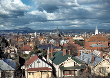 City of Ballarat Libraries
Slide, View east over houses from Ballarat Hospital circa late 1950s
... Hospital, looking east over Drummond Street to Mt Warrenheip... Ballarat Base Hospital, looking east over Drummond Street to Mt ...This image appears to have been taken from Ballarat Base Hospital, looking east over Drummond Street to Mt Warrenheip. The City Fire Brigade tower painted white can be seen to the right, while St Andrew's Kirk dominates the middle ground of the photograph. Many photographs over the years have been taken from this viewpoint, and are interesting to compare. Mrs Bon Strange and her husband Bert were well known Ballarat residents. When Mrs Strange died some years ago, her extensive slide collection was sorted through and those relevant to Ballarat were gifted to the Ballarat Library.mount warrenheip, ballarat east -
 Stawell Historical Society Inc
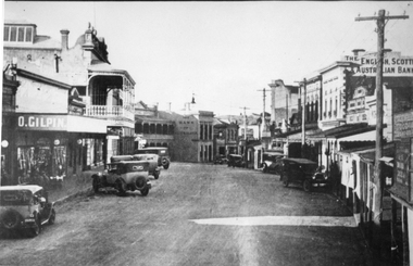
Photograph, Upper Main Street Stawell looking East 1930
... Upper Main Street Stawell looking East 1930...Upper Main Street looking East c 1930. Two Story shop... grampians Upper Main Street looking East c 1930. Two Story shop ...Upper Main Street looking East c 1930. Two Story shop on left behind O. Gilpin is Chadwicks Draper later partially destroyed by fire. Some buildings not visible, Commercial Hotel then Oriental Bank / The Bank Australasia in Centre of Photo, Punchard's Furniture. On right of street, side of Mechanics institute, B.S. Dawson Chemists & R.H. Wadsworth Watchmaker, the English Scottish & Australian Bank on right. Clark & Scott Drapery. stawell streetscape -
 Bendigo Historical Society Inc.
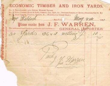
Document - J.F.WARREN INVOICE, 9/05/1891
... .) No. 3 Split Timber, Palings, Pickets, &c. (Hargreaves Street... Timber, Palings, Pickets, &c. (Hargreaves Street East). To: Mrs ...John Frederick Warren was born in England in 1834. After coming to Australia, he married Rebecca Baird in 1868. He initially tried his hand at mining before establishing his timber and iron works. He retired in 1902 and lived at "Bowden", Barnard Street, until his death 21/10/1912. Following his retirement, the business was continued by his son John Frederick Warren jnr (b. 1879).J.F.Warren Invoice: Cream paper with red print. Torn left bottom half. Economic Timber and Iron yards. NO. 1 Ironmongery and Office, Market Square. No 2 Sawn Timber (Hard & Soft), Cement. Gal. Iron. &c. Opposite School of Mines, (Hargreaves St. E.) No. 3 Split Timber, Palings, Pickets, &c. (Hargreaves Street East). To: Mrs Waldock. Sandhurst May 9th 1891. Please receive from J.F Warren, The undermentioned Goods in good order and condition:- General Importer. For 30 Yards 36 x 2 netting £10. Paid J.F.Warren per S. H. Box 625.Printed at 'The Bendigo Independent' Office.business, retail, house furnishings, j.f. warren. mrs waldock. -
 Learmonth and District Historical Society Inc.
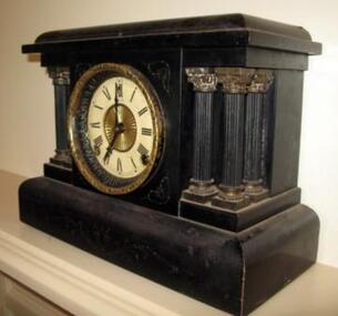
Mantle Clock, "circa 1910"
... . Welch (1809-1887),had been making clocks at a factory on East... at a factory on East Main Street Forestville Conneticut after taking ...Founded in1903 when William E.Sessions and some of his family took over E.N.Welch Co. in Forestville. E.N.Welch Manufacturing Company used a local foundry to produce their castings. The foundry owner's son,William E.Sessions, took an interest in horology and ,along with other Sessions family members, bought controlling interest in the E.N.Welch Company., which was a joint stock corporation formed July 6th 1864 to succeed an older private firm who made clocks under the name of E.N.Welch. Elisha N. Welch (1809-1887),had been making clocks at a factory on East Main Street Forestville Conneticut after taking over J.C.Browns bankrupt business around 1856.Under William Sessions management the firm produced all components of their clocks including movements,cases,dials,artworks and castings.In 1930 the company expanded to produce electric clocks,timers for radios,televisions and other devices as well as their traditional brass mechanicial movements.In 1956 Sessions was absorbed by another company while retaining the name and in 1969 the business went into liquidation.Clock is made of black wood with Corinthian style columns,three set on each front corner. These are black metal, and show remains of gilt paint on top of columns.On the base of the clock is carved decoration with similar carvings on each of the four corners of square around clock face.Dial is cream with Roman numerals. the hands are set in gilt centre piece.Below the 12 is the name WELCH.The glass dial cover is edged in gilt. It is spring wound and has settings-day/night,1/2 hour strike(hour on gong -1/2 0n bell), Cathederal Gong, turn back hands. THE SESSIONS CLOCK COMPANY. Successors to the E.N.WELCH MANUFACTURING COMPANY.Forestville.Conneticut.United States of America.mantle clock, the sessions clock company, forestville conneticut united states of america -
 Federation University Historical Collection
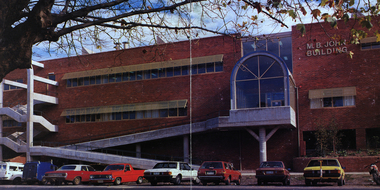
Image - Colour, Ballarat School of Mines M.B. John Building, Albert Street, Ballarat, 1987, 1987
... The M.B. John Trade–Art building (Albert Street front.... John Trade–Art building (Albert Street front) of SMB ...The M.B. John Trade–Art building (Albert Street front) of SMB was officially opened by the Hon. John Cain, Premier of Victoria, in the presence of Morgan B. John. Programs include 3 Dimensional Art, Painting & Decorating, and Engineering Trades. (SMB Institutional Plan 1989) The M.B. John Building (Building K), a three storey, face red brick, restrained Late Twentieth Century International styled building with an elongated, cuboid form (defined by the parapeted facades) that is offset by projecting exposed concrete framed, round‐arched entrance and stair wells on the east (Albert Street) elevation (the centrally located entrance breaking the brick façade with glazing). The facades are also characterised by banks of aluminium framed, horizontal ribbon windows, which wrap around the building corners. Metal shades project beyond the windows, while post‐supported bullnosed verandahs and hoods and projecting concrete stairs are other features. On the west elevation, the cuboid façade is punctuated by projecting curved concrete and glazed, elongated bays at first floor level. (David Rowe/Wendy Jacobs)Image of a multi-storey brick building on the Ballarat School of Mines campus. The building is known as the M.B. John Building.ballarat school of mines, m.b. john building, morgan b. john, albert street, m.b. john -
 Eltham District Historical Society Inc
Photograph - Aerial Photograph, Landata, Eltham, Vic, Apr. 1963
... to south, Main Road at Kent Hughes Road to east and Bolton Street... to south, Main Road at Kent Hughes Road to east and Bolton Street ...Centred on present day Eltham Lower Park bounded by Brougham Street to north, Yarra River and Fitzsimons Lane Bridge to south, Main Road at Kent Hughes Road to east and Bolton Street to west. Historic Aerial Imagery Source: Landata.vic.gov.au Aerial Photo Details: Project No :486 Project : MELBOURNE (1963) PROJECT Run : 7 Frame : 232 Date : 04/1963 Film Type : B/W Camera : RC8 Flying Height : 5100 Scale : 9600 Film Number : 1805 GDA2020 : 37°44'03"S, 145°08'33"E MGA2020 : 336329, 5822040 (55) Melways : 21 H10 (ed. 42)aerial photo, neil webster collection, 1963-04, bolton steet, brougham steet, eltham, eltham lower park, fitzsimons lane bridge, kent hughes road, melway 21h10, yarra river -
 City of Ballarat Libraries
35mm Slide, Sturt Street West, Ballarat circa late 1950s
... A lovely shot of the western end of Sturt Street, looking... Street, looking east to Mt Warrenheip. Not much traffic today ...A lovely shot of the western end of Sturt Street, looking east to Mt Warrenheip. Not much traffic today! Just a tram and an early Holden, yet at the time of this photograph, this was the main highway through to Adelaide. Mrs Bon Strange and her husband Bert were well known Ballarat residents. When Mrs Strange died some years ago, her extensive slide collection was sorted through and those relevant to Ballarat were gifted to the Ballarat Library.sturt street, trams -
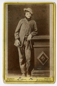 Victoria Police Museum
Carte de Visite (Dan Kelly standing), Dan Kelly (standing)
... Street. East Near parliament Houses. St Georges Hall Next... Photographic Rooms 209 Bourke Street. East Near parliament Houses. St ...Carte-de-visite is a small black and white photograph stuck to a card. It was invented by French photographer Andre Disderi in 1854 as a method for producing multiple images on a single glass plate, a format for mounting the resulting images on cards. The card on which the photograph was mounted displayed the name of the photographer on the front and back. The back was often a showy piece of lithographic printing with the photographer's name decorated with culicues.Sepia toned photograph on card showing Dan Kelly with left arm resting on a pillar."Burman Photo 200 Bourke St - East & St Georges Hall" (under photograph). "From Burman's Photographic Rooms 209 Bourke Street. East Near parliament Houses. St Georges Hall Next to Theatre Royal Melbourne. Portraits Enlarged, Copied or Colored. Views taken in any part of Victoria. Copies of this can be had at any time: (on rear) "Dan Kelly" (handwritten in ink underneath image on front of card)dan kelly, kelly gang, ned kelly, carte-de-visite, burman -
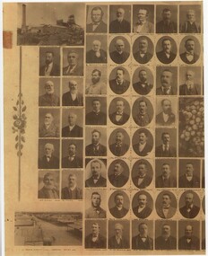 Rutherglen Historical Society
Image, c1880-1890
... Street-Looking East.... - Main Street-Looking East. Image ...Copy of a photograph of early pioneers of Rutherglen. Copy has been made in two sections. The original featured a bunch of grapes in the centre with individual photographs, grouped about the centre. Photographs of each individual are identified with their name below the image. Photos of local landmarks are at each corner: top left - Great Southern Mine, top right - Town Hall, bottom left - Main Street-Looking West, bottom right - Main Street-Looking East.rutherglen, rutherglen pioneers -
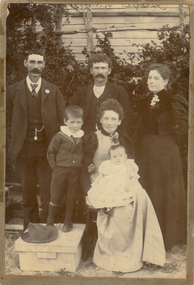 Ballaarat Mechanics' Institute (BMI Ballarat)
Brogden family
... Lal Street Ballarat East Joan and George Brogden (born 1894... and lived at 9 Lal Lal Street Ballarat East Joan and George Brogden ...This photograph is held in the Ballaarat Mechanics' Institute Audio Visual Collection. Please contact BMI for all print and usage inquiries. Left to Right John Brogden, David Brogden, Rosina Hayes George age 4, Harriet Brogden (nee Hayes), John Brogden 4 months John Brogden was born 1864 and lived at 9 Lal Lal Street Ballarat East Joan and George Brogden (born 1894) ran Bakery 1922-1966 which became Sunnycrust ballarat, brogden, family, 1880s -
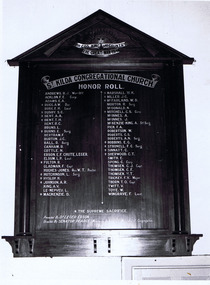 St Kilda Historical Society
Photograph, 31 December 1972
... and Inkerman Streets (later East St Kilda Uniting Church and now... at the corner of Hotham and Inkerman Streets (later East St Kilda ...St John’s Congregational Church was established in 1888 on the corner of Barkly and Mitford Streets, near the Village Belle Hotel in South St Kilda. The building has now been demolished. The photograph was taken at the final service. The church closed in 1974 and gave its hymn books, carpets and curtains to its sister church, East St Kilda Congregational Church at the corner of Hotham and Inkerman Streets (later East St Kilda Uniting Church and now Trinity-St Nicholas Church). black and white photographHonour board of Sth St Kilda Cong ch. Closing Service 31 Dec 1972. First World War 1914-18. SKHS 00771st kilda, churches, congregational churches, wwi, world war i, great war, honour roll, st john's congregational church -
 City of Ballarat Libraries
Slide - 35mm Slide, Children in Clayton Street, on their way to school circa 1950s
... clayton street, ballarat east...Mr and Mrs Strange lived in Clayton Street, Ballarat East... Ballarat East goldfields Mr and Mrs Strange lived in Clayton Street ...Mr and Mrs Strange lived in Clayton Street, Ballarat East. This photograph is likely taken from their home, and it may be their children and friends heading off to school one morning. Bon Strange titled this slide "Autumn Morn" Mrs Bon Strange and her husband Bert were well known Ballarat residents. When Mrs Strange died some years ago, her extensive slide collection was sorted through and those relevant to Ballarat were gifted to the Ballarat Library.autumn, children, ballarat, clayton street, ballarat east -
 Brighton Historical Society
Dress, Day dress, circa early 1900s
... together in Cheel Street, East Oakleigh. Walter, a building... Medbury (1887-1947). They lived together in Cheel Street, East ...This dress belonged to Mary Grace Medbury (nee Matthews, 1885-1967). Mary was born in Kansas, USA, and as a teenager travelled to Devon, England, before she came to Australia with her family and married Walter Ambrose Medbury (1887-1947). They lived together in Cheel Street, East Oakleigh. Walter, a building contractor, worked on numerous construction projects in the Melbourne area, including the Oakleigh Methodist Church, the HMAS Cerberus naval base and - closer to home - the former Brighton Courthouse, which was built in 1936 and still stands at 15 Boxshall Street. Mary gave the dress to her granddaughter, Fiona Nissen, when Fiona was a teenager. A Brighton local, Fiona donated it to the Society in 2013.White cotton muslin day dress with three-quarter length sleeves and square neckline, both edged with lace. The dress features white floral embroidery on the sleeves, skirt and front of bodice. Hook and eye fastenings at back.mary grace medbury, mary grace matthews, fiona nissen, migration, 1900s