Showing 1350 items
matching elizabeth road
-
 Mt Dandenong & District Historical Society Inc.
Photograph
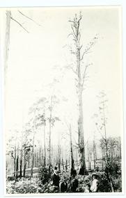
William Dower came with his family to the Mt Dandenong in 1898, taking up a 10 acre allotment. William and his wife Elizabeth had seven boys (Will, Harry, Bert, Walter, Joe, Edgar, Robert) and four girls (Emmy, May, Ada, Ruby). The property secured by William Dower was known as ‘Cambridge Gardens’ and had a two room slab hut. William and his sons added another five rooms using trees from the property. The family established extensive crops and worked hard for their success. The acreage extended to 30 when the family bought up neighbouring properties. Standing on William Dower's land this mighty tree was 286 feet high to its broken top with a 66 feet girth. It took Wally and Bert Dower a week to grub out the tree and then another week for the wind to blow it down.Black and white photograph with a very tall dead tree in the centre. A group of people visible in the foregrounddower, william dower, tree, wally dower, bert dower -
 Mt Dandenong & District Historical Society Inc.
Photograph, Kyeema Cairn 2003, 2003
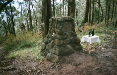
The cairn commemorating the Kyeema aircraft disaster with the addition of a smaller plaque listing the names of those who perished in the accident. This additional plaque was suggested by relatives of the victims who had attended earlier commemorations of the accident at the site. Mt Dandenong & District Historical Society members observed a minute's silence and drank a toast of South Australian wine, produced by vineyards with which some of the victims were associated, in memory of all those who lost their lives. The plaque reads: KYEEMA VH-UYC CREW AND PASSENGERS CAPTAIN ALFRED WEBB JUNIOR CAPTAIN ALLAN STEEN AIR HOSTESS ALVA JONES CADET PILOT PHILIP PRING LEONARD ABRAHAMS K.C. ALFRED GAIN HANS GLOE STELLA GLOE GORDON GODDARD HUGO GRAMP THOMAS HARDY CHARLES HAWKER M.H.R. GEORGE LING JAMES MASSIE VAUGHAN PATE ELIZABETH SCHRADER LANCELOT SHIRLEY SIDNEY HILL SMITHkyeema, air crash, mt dandenong, cairn, plaque, captain alfred webb, allan steen, elva jones, philip pring, leonard abrahams, alfred gain, hans gloe, stella gloe, gordon goddard, hugo gramp, thomas hardy, george ling, charles hawker, james massie, vaughan pate, elizabeth schrader, lancelot shirley, sidney hill smith -
 Mt Dandenong & District Historical Society Inc.
Photograph, Mt Dandenong School 3284 1942, 1942
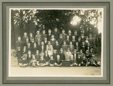
Formal school photograph of the students at Mt Dandenong State School taken in 1942. Mounted on stiff cardboard.Handwritten on back of photograph: Betty Jeeves (Law Smith) 1st right middle row Stamp G. E. Hains Photographer 654 CANTERBURY Rd. SURREY HILLS, E10mt dandenong school, betty jeeves, elizabeth law smith -
 Mt Dandenong & District Historical Society Inc.
Photograph, Mt Dandenong School 3284 1937, 1937
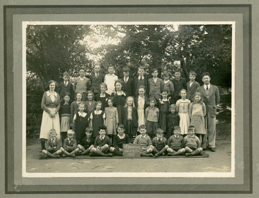
Formal school photograph showing staff and students of Mt Dandenong State School No. 3284 taken in 1937. Mounted on stiff cardboard.Handwritten on rear of photograph: Betty Jeeves (Law Smith) 3rd from right second front row. Ken Jeeves 1st left, back row. Stamped on back G.E.HAINS Photographer 61 HARCOURT ST. HAWTHORN EAST, E3 1/6mt dandenong school, betty jeeves, ken jeeves, elizabeth law smith -
 Mt Dandenong & District Historical Society Inc.
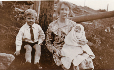
Photograph, Mrs Hubert Jeeves with children Kenneth and Elizabeth
Mrs Hubert Jeeves, nee Daisy Rowse with son Kenneth and daughter Elizabeth c1930.Sepia photograph showing woman seated in garden holding a baby wrapped in a blanket with a small boy seated beside her.daisy rowse, hubert jeeves, kenneth jeeves, elizabeth jeeves -
 Mt Dandenong & District Historical Society Inc.
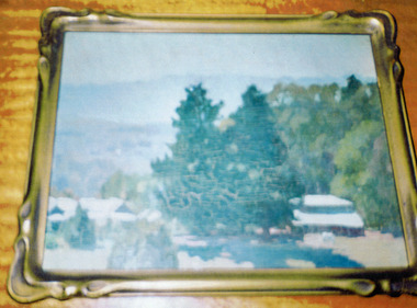
Photograph, Painting of Mountain Grange c1920, c1920
Photograph of a painting by artist Nora Gurdon of Kalorama depicting Mountain Grange and the Great Barn. The painting was lent to Robert Barrow in 1997 for the Mt Dandenong Primary School Centenary. After his death it was held by the Mt. Dandenong & District Historical Society until it was returned to Elizabeth Law-Smith (grand-daughter of Thomas and Eliza Hand) in 2005. Elizabeth Law-Smith lent the Jeeves photographs for copying. The Historical Society only has a photograph of the painting. A photograph of a second painting of a similar scene that is owned locally is also attached.mountain grange, eliza hand, thomas hand, nora gurdon -
 Mt Dandenong & District Historical Society Inc.
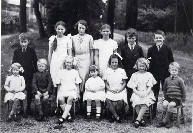
Photograph, Kalorama Methodist Sunday School at FiveWays c1940, c1940
Sunday School Photo. Standing L - R are Ken Jeeves, Dorothy Jeeves, Monnie Bowman, Edna Hodgson, Laurie Bowman, Billie Hodgson. Seated L - R are Betty Jeeves (Elizabeth Law-Smith), Don Jeeves, Irene Jeeves, Heather Jeeves, Esme Jeeves, Norma Jeeves, Laurence Jeeves. Esme, Heather and Dorothy Jeeves are the children of Walter and Dorothy Jeeves. Norma, Irene, Donald and Laurence Jeeves are the children of Norman and Adelie Jeeves (Worland) Ken and Betty Jeeves are the children of Hubert and Daisy Jeeves (Rowse)elizabeth jeeves, fiveways, kalorama methodist church, methodist church, ken jeeves, dorothy jeeves, monnie bowman, edna hodgson, laurie bowman, billie hodgson, don jeeves, irene jeeves, heather jeeves, esme jeeves, norma jeeves, laurence jeeves -
 Mt Dandenong & District Historical Society Inc.
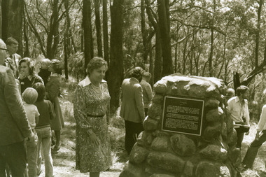
Photograph, Unveiling of the Kyeema Cairn October 25, 1978, 1978
Mrs Sybil Gramp, daughter-in-law of passenger Hugo Gramp, unveils the cairn's memorial plaque on the accident's 40th anniversary in 1978. Sybil Gramp was also a grand-daughter of one of the other victims, Mrs Elizabeth Schrader.air crash, kyeema, sybil gramp, hugo gramp, elizabeth schrader, cairn, mt dandenong -
 Ballarat Tramway Museum
Slide - 35mm slide/s - set of 11, Noel Simons, 23/10/1965 12:00:00 AM
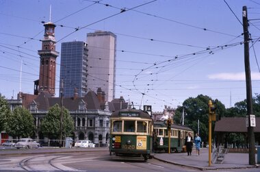
Set of 11 Kodachrome transparencies taken on 23/10/1965 in Melbourne. 1178.1 - W7 1020 (on route 9A, Northcote via St Georges Road) with a W2 536 (Deepdene) behind at the corner of Victoria Parade and Brunswick St. East Melbourne or Fitzroy. Has Eastern Hill fire station and ICI building in background. 1020 has front dash panel ads for Queens Bridge Motors and Bridgestone tyres. 1178.2 - W5 759 (route 19, North Coburg) and W5 807 in Elizabeth St. Melbourne at the intersection of Bourke St. with the State Savings Bank building in the background. 759 has side ads, one of which is for CASTROL. 1178.3 -SW6 903 crossing Brunswick St. in Victoria Parade, Fitzroy bound for Deepdene, route 45. Photo taken after tram has passed photographer. 1178.4 - W7 1019 (route 96, East Brunswick Blyth St.) and W7 1010 (route 88 East Preston) in Nicholson St at intersection with Victoria Parade. A Herald newspaper truck is alongside 1019. 1178.5 - W7 1040 (route 96, East Brunswick Blyth St.) in Nicholson St at intersection with Albert St. Has Princess Theatre in the background. (High res scan added 26/10/2008 - copy to FOHTD) .1178.6 - W6 974 (route 89 East Preston Bell St.) in Bourke St. about to turn into Spring St. Has buildings on the south side of Bourke St in background, including Southern Cross Hotel. Note trees in tubs and red phone box by Windsor Hotel. 1178.7 - as for same location as 1178.6 - SW6 967 (route 96) and W6 971 (inbound - route 90 - City Spencer St.) 967 has Lucas ad on front dash. 1178.8 - W7 1013 (route 88 East Preston) photographed from W6 991 in Bourke St at corner of Russell St. Has Normans corner store, Treadways and Foys in background. 1178.9 - W2 553 (route 1 East Coburg) at the corner of Elizabeth St and Bourke St. Has the Leviathan, Roger David and Ezywalkin shops in the background. 1178.10 - W6 991 (route 88) and W7 (route 96) in Bourke St. at corner with Elizabeth St. Photo taken from the GPO steps. 991 has ads for BIC pens and CASTROL. In background are the State Savings Bank, Halls Books and McEwans shops. 1178.11 - Line up of north bound trams (3 +) lead by W2 449and southbound in Elizabeth St at corner of Collins St. Has Flinders St. station building in the background. Hi -res image of .10 added 22-12-2018All have date stamp of "23 Oct 1965" in purple ink. All black ink unless otherwise noted. 1178.1 - "W7 1020 turning into Brunswick St. from Victoria parade, East Melbourne (followed by W2 536) 1178.2 - "W5 799 and 807 in Elizabeth St. Melbourne at cnr. of Bourke St." 1178.3 - "SW6 903 entering reserved track in Victoria Parade, East Melbourne" 1178.4 - "W7 1019 and 1010 in Nicholson St. East Melbourne at Victoria Pde intersection" 1178.5 - "W7 1040 Melbourne's last tram (to date) in Nicholson St. at Albert St. intersection." 1178.6 - "W6 974 in Bourke St. Melbourne, about to turn into Spring St." 1178.7 - "W6 971 entering Bourke St. from Spring St. Melbourne, passes SW6 967 outward bound for East Brunswick" 1178.8 - "W7 1013 (seen from W6 991) in Bourke St. Melbourne crossing Russell St." 1178. 9 -"W2 553 in Elizabeth St. Melbourne at cnr of Bourke St." 1178.10 - "W6 991 and W7 1005 in Bourke St. Melbourne at cnr of Elizabeth St." 1178.11 - "W2 449 leads a line of Peak hour cars along Elizabeth St. Melbourne (at Collins St. corner)"tramways, trams, melbourne, victoria parade, nicholson st., brunswick st., bourke st, elizabeth st, tram 1020, tram 536, tram 799, tram 807, tram 903, tram 1019, tram 1010, tram 1040, tram 974, tram 967, tram 971, tram 1013, tram 553, tram 991, tram 1005, tram 449 -
 Ballarat Tramway Museum
Album - Photo Album, Newstar, 1960s to 1970's
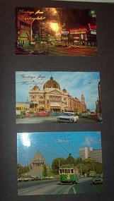
Photographic album containing 39 Colour postcards of Melbourne trams. The album consists of 30 leaves of dark grey heavy paper with three creases on left hand side of sheet, bound into a heavy bluey grey folder, embossed in gold 'Scrap Book" and bound with bluey grey string with two holes. The cover has been embossed with a the blue grey in swirls. Inside of back cover is a white label, "A New Star Product", with a please ask for No. with "425" stamped on. Postcards have been glued into the album. Entries have been kept to a single line - cards are able to be dated from buildings, whether the trams have marker lights, types of motor cars and general Melbourne history. Image files in page number order. Image 15 is of book. All taken with a electronic camera. Page 1 - Night photo - Flinders and Swanston St. - with "Greetings from Huntingdale" embossed in gold. Flinders St. station, with "Greetings from Huntingdale" embossed in gold. (post 1972 ) St. Kilda road with the Shrine of Remembrance in the background and W2 453 inbound on route 6. (post 1974) Page 2 - Bourke St, looking from Parliament House westwards, with Z8 inbound - after 13/8/1975 on route 89. Bourke St, looking east from Queen St., night photo, early 1970's. Princes Bridge looking towards Flinders St. Station Page 3 - Flinders St. Station, from Princes Gate buildings, - Photo E. Ludwig, John Hinde Studios. Bourke St. from Queen St, looking east, late 1960's - all W's. - W7 1026 east bound on route 88. Flinders St and Swanston St. corner, from Princes Bridge - night photo - W5 756 northbound route 15. Page 4 - W2 584 inbound route 64, St. Kilda Road and Nolan St., late 1960s - photograph. Princes Bridge, looking over Yarra River to the east. (pre Concert Hall) St. Kilda Road, with Shine of Remembrance in background, W2 303 inbound route 4D, mid 1960's. Page 5 - Flinders and Swanston St, W2 530 outbound route 8, early 1970's. Swanston and Collins St., W2 596 westbound in Collins St. City Square built - 1st version. (post 1972) St Kilda Road, with Shine in background, W2 298 and others, route 8 and 72. (post 1972) Page 6 - Flinders and Swanston St., W2, inbound route 5 on a wet evening. (mid 1970's) W2 515 outbound, Collins St., late 1960's, with Town Hall in background. (early 1970's, prior to lights) Collins St. looking west at Russell St with W2 637outbound route 42, early 1960's. Page 7 - Swanston St looking south at Little Bourke, W2's 373 route 67 and 374?(route 5), southbound, early 1970's Flinders St. Station, looking west in Flinders St., early 1970's, at dusk. Melbourne Town Hall with City Square from the North West (early 1970's) Page 8 - Bourke St looking east from Queen St. with W7 1005 inbound on route 96 - early 1970's. Bourke St. looking west from Exhibition St. with W6 976 outbound on route 95 - early 1970's. Swanston St. looking south from Lonsdale, with W2 484 on route 64, W2 228 and W2 364 in photo - early 1970's. Page 9 - Swanston looking south from north of Lonsdale St with many tramcars in photo - mid 1970's. St Kilda Road, with Shrine in background, W2 345 outbound route 4, SW6 913 inbound route 4 - prior to 1970. St Kilda Road, with Shrine in background, with trams in photo - early 1970's. (Photo loose in album - National View postcard by Murfett Ltd. Aust.) Page 10 - Postcard - TMSV? of 1041 and cable car set at Preston Workshops. 1041 in Bourke St., looking east from Queen St. - early 1970's - 1974? Collins St. looking east from Elizabeth St. with W2 253 inbound route 11, and W2 224 outbound - rout 47, early 1970's Page 11 - TMSV Postcard, X217 in Dandenong Road with L class in background. Shrine of Remberance from BP building, looking towards the city with St. Kilda Road on the left. Princes Gate and Flinders St. from the SEC buildings in Flinders St. looking south east - mid 1960's. Page 12 - Swanston St. at Flinders St. looking north at dusk. Flinders St. station at Swanston St with trams crossing at intersection - late 1960's Flinders St. station with W2 327 outbound. Page 13 - Temporary City Square at Collins and Swanston St. with tramcars at intersection. Wellington Parade (Mugs Alley), looking towards the City, with W2 546 inbound on route 38 - mid to late 1960's. Page 14 - Swanston St. looking south, at Lonsdale St, W2 432 inbound route 7 - late 1960's or early 1970's. Partly loose in album - National View postcard by Murfett Ltd. Aust. trams, tramways, photo album, melbourne, postcards -
 Ballarat Tramway Museum
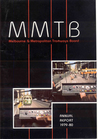
Document - Report, Melbourne and Metropolitan Tramways Board (MMTB), MMTB Reports 1979 to 1981, 1980 to 1982
Three copies of the Annual report of the MMTB for the years end 1980, 1981 and 1982 3953.1 - "Annual Report 1979-80" - white gloss paper with colour card covers with 36 pages, gloss, on inside giving details of the MMTB Board, Officers, Operations report, schedule of debenture, investments, Auditors reports, record of Annual traffic receipts, passengers, miles etc, tram and bus routes operated, statistical information, graphs and photographs. Photos include; Z 117 in Bourke St, Z 31 Burwood terminus, new safety tower wagon, Z118 in Bourke St, W2 528 High St Kew, reconstruction of High St Kew, Z3 120, cable and electric trams at Flemington Bridge, Z3 117, fitting trams to bogies at Preston workshops, Queens Bridge roundabout, MAN bus, Burwood substation, Z111 in Bourke St and Z's enter Elizabeth St service and Z3 129 on rear cover at night. 3953.2 - "Annual Report 1980-81" - white gloss paper with colour card covers with 36 pages, on inside giving details of the MMTB Board, Officers, Operations report, schedule of debenture, investments, Auditors reports, record of Annual traffic receipts, passengers, miles etc, tram and bus routes operated, statistical information, graphs and photographs. Photos include; image of Park St, Domain Road Jtn before changes, Museum station entrance, Flinders and Swanston St, CDB City Ring bus service, Swanston St, Westgate bus route, Park St, new substation, Swanston and Flinders St, Flinders land, and give way to buses pulling out of stops. 3953.2 - "Annual Report 1981-82" - white gloss paper with colour card covers with 36 pages, on inside giving details of the MMTB Board, Officers, Operations report, schedule of debenture, investments, Auditors reports, record of Annual traffic receipts, passengers, miles etc, tram and bus routes operated, statistical information, graphs and photographs. Photos include images of a z class crossing the Maribyrnong bridge, Footscray bus workshops, track renewals, a wedding at Wattle Park, a W2 arriving at Museum Station, Clifton Hill interchange, buses, Z class in Elizabeth St (Nos 158 and 43), Z89 in Mt Alexander Road North Essendon and a W2 loaded on a truck for New Zealand.3951.1 - has Graeme Breydon's address stamp on front cover., 3951.2 - ditto, 3951.3 - ditto and on inside of front cover., 3951.6 - "G. Breydon" in pencil on front cover and pencil comments on balance sheet., 3951.7 - dittotrams, tramways, mmtb, melbourne, annual reports, operations, trackwork -
 Otway Districts Historical Society
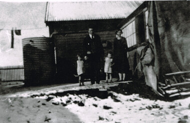
Photograph, Laurie McCabe, wife and children at their railway house, Beech Forest, Mid 1920s
In order to accommodate its key Otways staff of train crews, station masters and gangers the VR provided departmental housing. Laurie McCabe, a former porter at Wyelangta, a player in the local football team, and married to one of the potato-growing families, was the Station Master becoming the travelling station master and guard in 1930. He was based in Beech Forest and housed departmentally with his wife, Victoria Elizabeth (nee Tann) and their two children.Laurie McCabe, Travelling Station Master and goods Guard, his wife, Victoria, and their two children outside their railway house at Beech Forest. B/W.beech forest; railway; departmental housing; -
 Otway Districts Historical Society
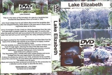
DVD, Lake Elizabeth, 2006
... Forest great-ocean-road Lake Elizabeth was formed when ...Lake Elizabeth was formed when a landslide slid into the valley damming the East Barwon River.Interviews with people who remember the formation of the Lake.30 Minute video of the creation of the lake in 1952lake elizabeth forrest east barwon -
 Colac RSL Sub Branch
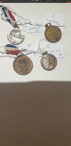
Medal - Medals x 4, a) Centenary of Melbourne medal. b) Borough & Shire of Colac. 1945 Peace & Victory Medal. c) Coronation Medal 1937. d) Victory Medal 1945, NK
Commemorative medallionsmediumRound commemorative medals x 4. a) Silver coloured medal with a with Red, white and blue ribbon. b) Bronze coloured medal. No ribbon c) Bronze " " with a red, white and blue ribbon d) Silver " " . No ribbon a) Front:- Centenary of Melbourne. 1932. Man looking at city skyline. 1835. Back:- Centenary of Victoria. 1934. Sailing ship/shoreline. 1834 b) Front:- Borough & Shire of Colac. Coat of Arms surrounded by wreath and crossed swords. Back:- Peace and Victory. Surrounded by a wreath c) Front:- King George VI & Queen Elizabeth. Portraits of King and Queen Back:- To Commemorate their Majesties' Coronation d) Front:- Man with a sword on a map of Australia. 1945 Back:- Map -
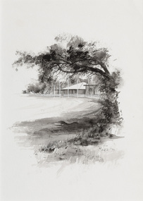
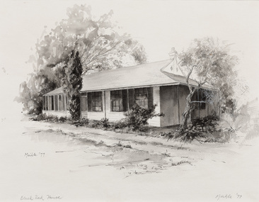
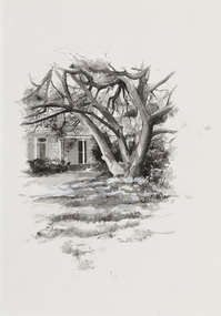
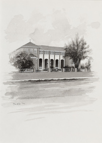
 Bayside Gallery - Bayside City Council Art & Heritage Collection
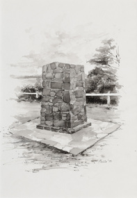
Work on paper - ink and watercolour, Annette Meikle, Moysey Memorial, 1977
In 1977, artist Annette Meikle undertook a commission to illustrate a book recording stories of places and people in the Bayside area. It was published in 1978 as Sandringham Sketchbook, with text by Elizabeth Waters. The sketches were intended to record remaining examples of Bayside’s early architecture and environment, as well as reflect newer architectural changes. Meikle went on to donate 22 of these sketches to Bayside City Council in 2003. Erected in 1964, this stone cairn on Beach Road in Beaumaris marks the site of the wattle and daub cottage of James and Susannah Moysey. James, Susannah and their cousin Nicholas arrived in Victoria in 1844 and leased land on the cliff-top. They built a cottage, cleared the land for sheep and cattle and established vegetable gardens. They later purchased the land and named it Beaumaris Park, derived from the name of the Welsh coastal resort where Edward I built Beau Marais castle.Annette Meikle, Moysey Memorial 1977, ink and watercolour, 35 x 23.5 cm. Bayside City Council Art and Heritage Collection. Donated by the artist, 2003annette meikle, sandringham sketchbook, elizabeth waters, port phillip bay, moysey memorial, coastline, stone cairn, james and susannah moysey, beaumaris -
 Bayside Gallery - Bayside City Council Art & Heritage Collection
Work on paper - ink and watercolour, Annette Meikle, Semco Park, 1977
In 1977, artist Annette Meikle undertook a commission to illustrate a book recording stories of places and people in the Bayside area. It was published in 1978 as Sandringham Sketchbook, with text by Elizabeth Waters. The sketches were intended to record remaining examples of Bayside’s early architecture and environment, as well as reflect newer architectural changes. Meikle went on to donate 22 of these sketches to Bayside City Council in 2003. Semco Park was a model of exemplary modern business in the 1920s. Located on Cheltenham Road, Black Rock, then considered to be an outer suburb, the property was home to Semco, a manufacturing and importing business of paper goods and cotton fabric items. The business’s governing director, Charles Mylius, wanted a firm that treated staff with fairness, created healthy and spacious working sites and offered recreational facilities. The site contained a factory as well as three houses for staff, a park with lawns, trees and flowerbeds, a cricket oval and a canteen serving hot food. Staff enjoyed soft background music played in the factory, and benefited from a superannuation scheme. Semco Park was sold to developers in 1977 but the business continued until the early 1990s with the office moving to Mulgrave, while factory work shifted to New Zealand.Annette Meikle, Semco Park 1977, ink and watercolour, 25.8 x 35.7 cm. Bayside City Council Art and Heritage Collection. Donated by the artist, 2003annette meikle, sandringham sketchbook, elizabeth waters, semco park, semco, cheltenham road, black rock -
 Bayside Gallery - Bayside City Council Art & Heritage Collection
Work on paper - ink and watercolour, Annette Meikle, Donald MacDonald Reserve, 1977
In 1977, artist Annette Meikle undertook a commission to illustrate a book recording stories of places and people in the Bayside area. It was published in 1978 as Sandringham Sketchbook, with text by Elizabeth Waters. The sketches were intended to record remaining examples of Bayside’s early architecture and environment, as well as reflect newer architectural changes. Meikle went on to donate 22 of these sketches to Bayside City Council in 2003. An area of natural bushland on Haydens Road, Beaumaris, was set aside in the early twentieth century as a reserve in memory of journalist and naturalist Donald MacDonald (c. 1859 – 1932). MacDonald was trained as a teacher but became a journalist for The Argus and The Australasian, working as a war correspondent, cricket commentator and nature writer. In 1900 he began the popular Argus column Nature notes and queries. Part of the Donald MacDonald Reserve was later cleared for an oval, a club pavilion and a scouts hall. Annette Meikle, Donald MacDonald Reserve 1977, ink and watercolour, 35.9 x 25.5 cm. Bayside City Council Art and Heritage Collection. Donated by the artist, 2003annette meikle, sandringham sketchbook, elizabeth waters, donald macdonald reserve, donald macdonald, journalist, naturalist, oval, sports pavilion, beaumaris -
 Bayside Gallery - Bayside City Council Art & Heritage Collection
Work on paper - ink and watercolour, Annette Meikle, Black Rock House, 1977
In 1977, artist Annette Meikle undertook a commission to illustrate a book recording stories of places and people in the Bayside area. It was published in 1978 as Sandringham Sketchbook, with text by Elizabeth Waters. The sketches were intended to record remaining examples of Bayside’s early architecture and environment, as well as reflect newer architectural changes. Meikle went on to donate 22 of these sketches to Bayside City Council in 2003. Black Rock House was built in 1858 by wealthy land dealer and politician Charles Hobson Ebden as a holiday home on 112 acres of virgin scrub, taking in the area of present day Balcombe Road, Beach Road and the line of Keating Street. The house included four bedrooms, a cellar, stables and a courtyard enclosed in castle-like sandstone walls. It was named Black Rock House after Black Rock Castle near Dublin, associated with Mrs Ebden’s childhood.Annette Meikle, Black Rock House 1977, ink and watercolour, 33 x 53.5 cm. Bayside City Council Art and Heritage Collection. Donated by the artist, 2003annette meikle, sandringham sketchbook, elizabeth waters, black rock house, black rock, charles hobson ebden, architecture, historic house -
 Bayside Gallery - Bayside City Council Art & Heritage Collection
Work on paper - ink and watercolour, Annette Meikle, Shenval, 1977
In 1977, artist Annette Meikle undertook a commission to illustrate a book recording stories of places and people in the Bayside area. It was published in 1978 as Sandringham Sketchbook, with text by Elizabeth Waters. The sketches were intended to record remaining examples of Bayside’s early architecture and environment, as well as reflect newer architectural changes. Meikle went on to donate 22 of these sketches to Bayside City Council in 2003. Built in 1891 for Captain Murray to his own design, ‘Shenval’ originally stood on five acres fronting Bluff Road, Black Rock.Annette Meikle, Shenval 1977, ink and watercolour, 33 x 23.5 cm. Bayside City Council Art and Heritage Collection. Donated by the artist, 2003annette meikle, sandringham sketchbook, elizabeth waters, black rock, architecture, historic house, shenval, captain murray, bluff road, verandah -
 Bayside Gallery - Bayside City Council Art & Heritage Collection
Work on paper - ink and watercolour, Annette Meikle, Chinese Elm - Corner Beach Road and Hampton Street, 1977
In 1977, artist Annette Meikle undertook a commission to illustrate a book recording stories of places and people in the Bayside area. It was published in 1978 as Sandringham Sketchbook, with text by Elizabeth Waters. The sketches were intended to record remaining examples of Bayside’s early architecture and environment, as well as reflect newer architectural changes. Meikle went on to donate 22 of these sketches to Bayside City Council in 2003. The Chinese Elm tree illustrated here marks the site of ‘Esmeralda’ which stood at at 312-314 Hampton Street, Hampton. It was a rambling house built in 1872 by Alfred William Harston and demolished in the 1970s. The elm is thought to be over 150 years old and was preserved by Council when flats were built on the site. It is recognised in the Significant Tree Register of Bayside City Council.Annette Meikle, Chinese Elm - Corner Beach Road and Hampton Street 1977, ink and watercolour, 33.8 x 23.7 cm. Bayside City Council Art and Heritage Collection. Donated by the artist, 2003annette meikle, sandringham sketchbook, elizabeth waters, chinese elm, esmeralda, alfred william harston, significant tree, historic house, hampton, hampton street -
 Bayside Gallery - Bayside City Council Art & Heritage Collection
Work on paper - ink and watercolour, Annette Meikle, St Vincent de Paul's Children's Home, 1977
In 1977, artist Annette Meikle undertook a commission to illustrate a book recording stories of places and people in the Bayside area. It was published in 1978 as Sandringham Sketchbook, with text by Elizabeth Waters. The sketches were intended to record remaining examples of Bayside’s early architecture and environment, as well as reflect newer architectural changes. Meikle went on to donate 22 of these sketches to Bayside City Council in 2003. This red brick building in Balcombe Road, Black Rock, was constructed in the inter-war period (1939) as a holiday home for State wards and neglected children who were placed in the care of the Sisters of Mercy.Annette Meikle, St Vincent de Paul's Children's Home 1977, ink and watercolour, 35.7 x 25.6 cm. Bayside City Council Art and Heritage Collection. Donated by the artist, 2003annette meikle, sandringham sketchbook, elizabeth waters, st vincent de paul's children's home, balcombe road, black rock, sisters of mercy -
 Bayside Gallery - Bayside City Council Art & Heritage Collection
Work on paper - ink and watercolour, Annette Meikle, Church of England, 1977
In 1977, artist Annette Meikle undertook a commission to illustrate a book recording stories of places and people in the Bayside area. It was published in 1978 as Sandringham Sketchbook, with text by Elizabeth Waters. The sketches were intended to record remaining examples of Bayside’s early architecture and environment, as well as reflect newer architectural changes. Meikle went on to donate 22 of these sketches to Bayside City Council in 2003. All Souls Memorial Church, located at 48 Bay Road, Sandringham, is believed to be the first reinforced concrete church in Australia. The foundation stone laid on 7 September 1919 and was consecrated in December 1921, the church seats 350 and contains an organ loft, a marble chancel floor, and Australian hardwood pulpit and pews.Annette Meikle, Church of England 1977, ink and watercolour, 35.6 x 25 cm. Bayside City Council Art and Heritage Collection. Donated by the artist, 2003annette meikle, sandringham sketchbook, elizabeth waters, all souls memorial church, church, building, architecture, bay road, sandringham, church of england -
 Bayside Gallery - Bayside City Council Art & Heritage Collection
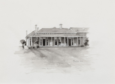
Work on paper - ink and watercolour, Annette Meikle, Beaumaris RSL, 1977
In 1977, artist Annette Meikle undertook a commission to illustrate a book recording stories of places and people in the Bayside area. It was published in 1978 as Sandringham Sketchbook, with text by Elizabeth Waters. The sketches were intended to record remaining examples of Bayside’s early architecture and environment, as well as reflect newer architectural changes. Meikle went on to donate 22 of these sketches to Bayside City Council in 2003. This gun stood in the grounds of the Beaumaris RSL, located on the highest hill in Beaumaris – more than 300 metres above sea level. The ‘25-pounder’ was one of the best field guns of its day and was used by British and Commonwealth armies during the Second World War. The original ten-acre property, which was the former holiday home of wealthy Toorak resident Langford-Jack, was sold to the Legacy Club in 1942 and operated as a holiday home for Legacy children. Renamed Blamey House in honour of Field-Marshall Sir Thomas Blamey, it was purchased by the RSL in 1955. The Beaumaris RSL Club closed its doors on Balcombe Road in 2016 after the property was sold in 2013.Annette Meikle, Beaumaris RSL 1977, ink and watercolour, 33.8 x 23.5 cm. Bayside City Council Art and Heritage Collection. Donated by the artist, 2003annette meikle, sandringham sketchbook, elizabeth waters, beaumaris rsl, 25-pounder, field gun, military weapon, langford-jack, blamey house, balcombe road, beaumaris -
 Bayside Gallery - Bayside City Council Art & Heritage Collection
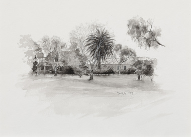
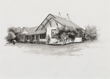
Work on paper - ink and watercolour, Annette Meikle, Hollyburton, 1977
In 1977, artist Annette Meikle undertook a commission to illustrate a book recording stories of places and people in the Bayside area. It was published in 1978 as Sandringham Sketchbook, with text by Elizabeth Waters. The sketches were intended to record remaining examples of Bayside’s early architecture and environment, as well as reflect newer architectural changes. Meikle went on to donate 22 of these sketches to Bayside City Council in 2003. ‘Hollyburton’ was built in 1908 by the Honourable JV Fairbairn MHR and is notable for its Australian-style arts and crafts detailing. Located on Fernhill Road, Sandringham, it covered 930 square metres and included a servants’ wing.Annette Meikle, Hollyburton 1977, ink and watercolour, 25.8 x 35.6 cm. Bayside City Council Art and Heritage Collection. Donated by the artist, 2003annette meikle, sandringham sketchbook, elizabeth waters, hollyburton, honourable jv fairbairn mhr, arts and crafts, architecture, historic house, fernhill road, sandringham -
 Bayside Gallery - Bayside City Council Art & Heritage Collection
Work on paper - ink and watercolour, Annette Meikle, Sandringham Club, 1977
In 1977, artist Annette Meikle undertook a commission to illustrate a book recording stories of places and people in the Bayside area. It was published in 1978 as Sandringham Sketchbook, with text by Elizabeth Waters. The sketches were intended to record remaining examples of Bayside’s early architecture and environment, as well as reflect newer architectural changes. Meikle went on to donate 22 of these sketches to Bayside City Council in 2003. In the mid 1870s wealthy solicitor David Abbot bought a large block on the corner of Bamfield Street and Beach Road and built an imposing family home with a stately tower. It featured rare Hawthorn Blacks – hand-made bricks of brown-red with streaks of charcoal black. For many years the home was the most prominent in the district. In 1922 ‘Coggeshall’ was subdivided, and the house was sold to the Sandringham Club, a gentleman’s club that had formed in 1913 and required more space for its growing membership. Members enjoyed lawn tennis courts, a bowling green and a cricket green, as well as a large billiard room. The Sandringham Club still owns ‘Coggeshall’.Annette Meikle, Sandringham Club 1977, ink and watercolour, 25.7 x 35.7 cm. Bayside City Council Art and Heritage Collection. Donated by the artist, 2003annette meikle, sandringham sketchbook, elizabeth waters, sandringham, sandringham club, gentleman’s club, coggeshall, david abbot, historic house -
 Bayside Gallery - Bayside City Council Art & Heritage Collection
Work on paper - ink and watercolour, Annette Meikle, Karinga, 1977
In 1977, artist Annette Meikle undertook a commission to illustrate a book recording stories of places and people in the Bayside area. It was published in 1978 as Sandringham Sketchbook, with text by Elizabeth Waters. The sketches were intended to record remaining examples of Bayside’s early architecture and environment, as well as reflect newer architectural changes. Meikle went on to donate 22 of these sketches to Bayside City Council in 2003. This inter-war house located at 60 Bluff Road, Black Rock, was built in 1926 for former Scotland Yard and Criminal Investigation Branch detective Horatio Reginald Clarence McWilliams. When McWilliams died it was found that he had taken extreme measures to protect his security. All the windows were nailed shut, a network of burglar alarms ran through the house and a complicated underground air raid shelter had been built in the garden. The security measures were at odds with the name of the house – Karinga or Karinya – an Aboriginal word meaning peaceful, happy home. Later residents of ‘Karinga’ included Senator Don Chipp and his family. The property has since been demolished and apartments have been built on the land.Annette Meikle, Karinga 1977, ink and watercolour, 32 x 23.5 cm. Bayside City Council Art and Heritage Collection. Donated by the artist, 2003annette meikle, sandringham sketchbook, elizabeth waters, black rock, karinga, karinya, horatio reginald clarence mcwilliams, senator don chipp, historic house, bluff road -
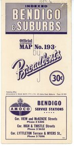 Bendigo Historical Society Inc.
Map - Three Road Maps of Bendigo, 1962
George Robert Broadbent (1863-1947), cyclist and map publisher, was born on 3 November 1863 at Ashby near Geelong, Victoria, son of George Adam Broadbent, Lancashire-born draper, and his wife Elizabeth, née Ruffhead. When the family moved to North Melbourne Broadbent attended the Errol Street school, followed his father's trade, and became an early cycling and cycle-racing enthusiast. At various times Broadbent held most Victorian and Australian road records, and two of his performances on solid tyres—203 miles (327 km) in 24 hours on a penny farthing, and 100 miles (161 km) in 6 hours 20 minutes on a 'safety' bicycle—were never bettered. He established records for all distances between 130 and 220 miles (209 and 354 km), and for all times between 8 and 12 hours, at the Exhibition Grounds track in May 1894, and road records for 50 and 100 miles (80 and 161 km) in October 1896. The Australian Cyclist acknowledged him 'the finest road rider that Australia has ever produced'. A foundation councillor of the League of Victorian Wheelmen in October 1893, Broadbent contested the first Warrnambool-Melbourne race in 1895, and was active in the Good Roads Movement. Next year he issued a road map of Victoria, 'prepared … after some sixteen years riding and touring in all parts of the Colony', which indicated general topography, distances, and roads classified as 'good', 'fair' or 'ridden with difficulty'. It was to become Victoria's standard map, and the basis of a continuous publishing programme by Broadbent's Official Road Guides Co.Three Road Maps of Bendigo, Bendigo and Suburbs, Bendigo and Eaglehawk. Two fold out maps printed in colour and produced by Broadbent's Road Maps Pty. Ltd. 475 Collins Street Melbourne. One map printed by Bolton's Bendigo.history, bolton's, bendio broadbent maps -
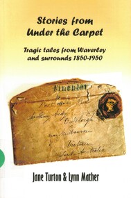 Surrey Hills Historical Society Collection
Book, Jane Turton et al, Stories from under the carpet: tragic tales from Waverley and Surrounds 1850-1950, 2019
These stories grew out of a presentation the author made to the Waverley Historical Society. They are of actual events that happened in and around Waverley in Victoria. The events were and still are tragic, some leaving a significant impact on the family members left behind.These stories grew out of a presentation the author made to the Waverley Historical Society. They are of actual events that happened in and around Waverley in Victoria. The events were and still are tragic, some leaving a significant impact on the family members left behind.james wynn, charles andrew, william aedy, bernerd moylan, herbert james williams, alexander cameron, george houghting, percival cornell, archie mouat, elizabeth law, alcock family, mcguire family, alfred atherton, leslie richard mcallister, winifred liddle hourigan, murders, mysteries, harie dartin, harie diclen, william brialey, ada brialey, roy sefton, amy sefton, dorothea gardiner, aaron gardiner -
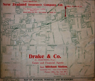 Kew Historical Society Inc
Map - Street Map, R L Jarrett, Map of Mitcham, Tunstall and Blackburn, 1929
Tunstall was originally the name of Nunawading Railway Station. Tunstall opened on 4 June 1888 and was renamed on 1 November 1945. An historically significant advertising map that can be used to ascertain the extent of urban development in 1929 in the areas of Nunawading, Blackburn and Mitcham.A map of Mitcham, Tunstall and Blackburn found on the reverse of a real estate subdivision plan published by R. L. Jarrett of Elizabeth Street. This promotional street map is overprinted with the business address of the sponsors and advertising. Map overlaid in red print: "Drake & Co. / (N. Armstrong, Prop.) / Estate and Financial Agents / next Mitcham Station / Established 1914. Open all day Saturday. / Phones: Office, Box Hill 289 J. / Private, Vermont 10."real estate agents, mitcham, tunstall, blackburn, road maps, drake & co, new zealand insurance co ltd -
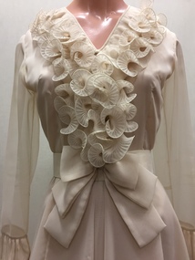 Kew Historical Society Inc
Clothing - Silk Organza Wedding Dress, Oggi Fashion House, 1971
Fashion by Oggi, as the sign above the door proclaimed, was located at the Paris End of Collins Street, on the south side, virtually opposite Lilian Weightman’s Le Louvre boutique. Janet Brock, who at the time was working in the Central Business District of Melbourne, had stopped to admire a mauve version of the dress that was displayed in the window, and, on making inquiries from the proprietress, ordered a made-to-measure cream-coloured copy. Her marriage occurred shortly after the death of her father, and took place on 18 December 1971 at the Kew Presbyterian Church in Cotham Road, where the Rev. Peter Mackie was the celebrant. The Fashion & Design collection of the Kew Historical Society includes examples of women’s, men’s, children’s and infants’ clothing from the 18th, 19th and 20th centuries. Items in the collection were largely produced for, or purchased by women in Melbourne, and includes examples of outerwear, protective wear, nightwear, underwear and costume accessories.Wedding dress, purchased by Janet Elizabeth Brock in December 1971 from Oggi of Collins Street. The wedding dress, reaching just below the knee, is lined in silk with a double outer layer of organza. The striking decoration of the monochromatic cream dress is achieved through the use of wide ruffled organza frills at the neck, on the sleeves and at the flared hem of the dress. The dress has a discrete v-neckline with small, self-covered buttons at centre front. At the back, the dress is closed with a nylon zip. In addition to the elaborate stiffened frills, the dress features a wide fabric belt with a double bow, worn at the front. oggi - 103-105 collins street - melbourne (vic), women's clothing, wedding dresses, janet (brock) walker, australian fashion - 1970s