Showing 3041 items matching "street works"
-
 Bendigo Historical Society Inc.
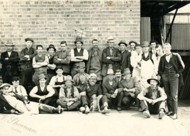
Document - The Reynolds Family Records Collection (Folder 4 of 4) Robert Reynolds and Unknown Group, Abt 1913
... Streets which later became an electrical substation. She sold poultry and eggs and preserves. One of Eleanor's sons, William John, married Anna (Annie) Jorgensen, and one of her daughters. Amelia, married Anna's brother Thomas Joynes Jorgensen. The Jorgensens founded and managed Jorgensen and Sons foundry and engineering works...Streets which later became an electrical substation. She sold poultry and eggs and preserves. One of Eleanor's sons, William John, married Anna (Annie) Jorgensen, and one of her daughters. Amelia, married Anna's brother Thomas Joynes Jorgensen. The Jorgensens founded and managed Jorgensen and Sons foundry and engineering works ...Eleanor Hinde (1842-1902) was born in Lancashire England. In 1858, Eleanor married Richard Reynold in the Forest St Wesleyn Methodist Church in Sandhurst. They both gave their address as Sailors Gully Goldfields. They had seven children together. Richard was a skilled tradesman and after he died in 1872 from lung disease, Eleanor married Arculus Opie. Eleanor owned a property on the corner of Gladstone and Stanley Streets which later became an electrical substation. She sold poultry and eggs and preserves. One of Eleanor's sons, William John, married Anna (Annie) Jorgensen, and one of her daughters. Amelia, married Anna's brother Thomas Joynes Jorgensen. The Jorgensens founded and managed Jorgensen and Sons foundry and engineering works. Peter Jorgensen (1849-1914), was a mining contractor, he lived at, "Bro," Russell street, Quarry Hill. His firm was Jorgensen and Sons, mining contractors. He was a native of the Island of Alsen, Denmark. He left Denmark in the year 1861, embarking at Hamburg in a small sailing Ship. The four folders contain family history documents and photos of the descendants of Eleanor Hinde. This item contains the following documents: Black and White Photo of Robert Reynolds (in suit) and Unknown group, taken by V. Sheenan, in about 1913, Robert died in 1916bendigo, sandhurst, peter jorgensen, eleanor hinde, eleanor reynolds, eleanor opie, reynolds collection, robert reynolds -
 Bendigo Historical Society Inc.
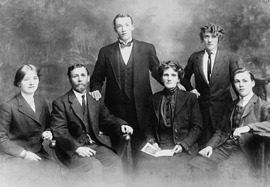
Document - The Reynolds Family Records Collection (Large portraits and four folders), Abt 1900
... Streets which later became an electrical substation. She sold poultry and eggs and preserves. One of Eleanor's sons, William John, married Anna (Annie) Jorgensen, and one of her daughters. Amelia, married Anna's brother Thomas Joynes Jorgensen. The Jorgensens founded and managed Jorgensen and Sons foundry and engineering works...Streets which later became an electrical substation. She sold poultry and eggs and preserves. One of Eleanor's sons, William John, married Anna (Annie) Jorgensen, and one of her daughters. Amelia, married Anna's brother Thomas Joynes Jorgensen. The Jorgensens founded and managed Jorgensen and Sons foundry and engineering works ...Eleanor Hinde (1842-1902) was born in Lancashire England. In 1858, Eleanor married Richard Reynold in the Forest St Wesleyn Methodist Church in Sandhurst. They both gave their address as Sailors Gully Goldfields. They had seven children together. Richard was a skilled tradesman and after he died in 1872 from lung disease, Eleanor married Arculus Opie. Eleanor owned a property on the corner of Gladstone and Stanley Streets which later became an electrical substation. She sold poultry and eggs and preserves. One of Eleanor's sons, William John, married Anna (Annie) Jorgensen, and one of her daughters. Amelia, married Anna's brother Thomas Joynes Jorgensen. The Jorgensens founded and managed Jorgensen and Sons foundry and engineering works. Peter Jorgensen (1849-1914), was a mining contractor, he lived at, "Bro," Russell street, Quarry Hill. His firm was Jorgensen and Sons, mining contractors. He was a native of the Island of Alsen, Denmark. He left Denmark in the year 1861, embarking at Hamburg in a small sailing Ship. The four folders contain family history documents and photos of the descendants of Eleanor Hinde, plus five large family black and white portraits This item contains the portraits: 11132.1a Robert Reynolds 11132.1b Family of Charles and Ellen Reynolds (presumed sitting 2nd and 3rd from the left), about 1915, with their family, Amelia, Robert, Louisa and Hector. 11132.1c Amelia Reynolds 11132.1d Maybe Ellen Reynolds 11132.1e Unknownbendigo, sandhurst, peter jorgensen, eleanor hinde, eleanor reynolds, eleanor opie, reynolds collection -
 Melbourne Water
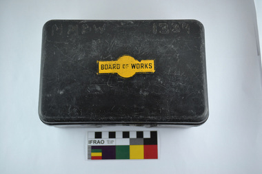
First Aid Kit (plastic lunch box), 1970s
... Melbourne Water 990 La Trobe Street Docklands melbourne As the Yarra became unsuitable as a source of water, several attempts were made to find alternative sources for the growing population of Melbourne. It was not until 1891 that the efforts to sewer Melbourne came to fruition with the setting up of the Melbourne Metropolitan Board of Works (MMBW), now known as Melbourne Water. ...As the Yarra became unsuitable as a source of water, several attempts were made to find alternative sources for the growing population of Melbourne. It was not until 1891 that the efforts to sewer Melbourne came to fruition with the setting up of the Melbourne Metropolitan Board of Works (MMBW), now known as Melbourne Water. From 1891 until 1992, it was the responsibility of the MMBW to safeguard public health by providing a sewerage system and a safe water supply system. In 1992, The MMBW merged with a number of smaller urban water authorities to form Melbourne Water.This first aid kit is of historical significance for its association with the former Melbourne and Metropolitan Board of Works (MMBW). The kit is relatively intact and a rare surviving object of standard Board issued equipment. The kit is significant for its representativeness of the theme of Safety that continues to resonate strongly within Melbourne Water today. First Aid Kit (plastic lunch box)MMBW 1339 (burnt into plastic) Board of Works Decalmelbourne metropolitan board of works, melbourne water, first aid kit, mmbw, safety, water, sewerage -
 Melbourne Water
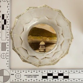
Souvenir confectionery bowl, 1930s-40s
... Melbourne Water 990 La Trobe Street Docklands melbourne Melbourne Water inherited many of its water assets, such as reservoirs from its predecessor the Melbourne Metropolitan Board of Works (MMBW). ...Melbourne Water inherited many of its water assets, such as reservoirs from its predecessor the Melbourne Metropolitan Board of Works (MMBW). They have served the organisation well and have long been celebrated for both their natural beauty and engineering ingenuity. In the nineteenth century Victoria’s fundamental need for water infrastructure went beyond merely functional solutions and reflected the English ideal of the romance and beauty that was embodied in expanses of water. The MMBW further enhanced this notion by incorporating beauty and function in to the Classical and Italianate designs of its infrastructure such as pumping houses and reservoir outlet towers. The reservoir gardens and picnic areas were landscaped with ornamental stonework, exotic trees, decorative flower beds, fern glades pools and rose gardens. All features of the water supply system became widely celebrated as beauty spots that continue to be very popular to this day with tourists and locals alike. This souvenir is a product of that flourishing tourist trade. These water supply sites continue to enhance Melbourne’s charm and liveability and are now recognised as places of cultural and historic significance. This souvenir item has been curated by Melbourne Water as it represents an important historical aspect of the organisation by demonstrating the popularity of its water asset sites as recreational places and tourist attractions, and although these sites are functional parts of the water supply system, they were also designed to be enjoyed by the public both aesthetically and recreationally. Clear glass flower shaped 'depression ware' confectionery bowl, with photographic image of Maroondah Reservoir outlet tower on basemelbourne metropolitan board of works, mmbw, maroondah reservoir, melbourne water, scenic view, souvenir, glass bowl -
 Melbourne Water
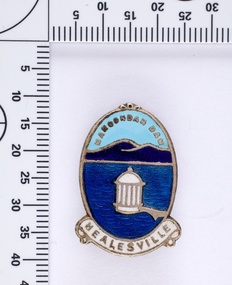
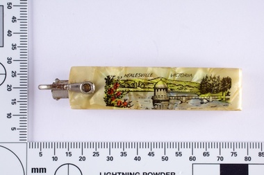
Souvenir lapel pin/brooch Maroondah Dam, 1960s/70s
... Melbourne Water 990 La Trobe Street Docklands melbourne Melbourne Water inherited many of its water assets, such as reservoirs from its predecessor the Melbourne Metropolitan Board of Works (MMBW). ...Melbourne Water inherited many of its water assets, such as reservoirs from its predecessor the Melbourne Metropolitan Board of Works (MMBW). They have served the organisation well and have long been celebrated for both their natural beauty and engineering ingenuity. In the nineteenth century Victoria’s fundamental need for water infrastructure went beyond merely functional solutions and reflected the English ideal of the romance and beauty that was embodied in expanses of water. The MMBW further enhanced this notion by incorporating beauty and function in to the Classical and Italianate designs of its infrastructure such as pumping houses and reservoir outlet towers. The reservoir gardens and picnic areas were landscaped with ornamental stonework, exotic trees, decorative flower beds, fern glads pools and rose gardens. All features of the water supply system became widely celebrated as beauty spots that continue to be very popular to this day with tourists and locals alike. This souvenir is a product of that flourishing tourist trade. These water supply sites continue to enhance Melbourne’s charm and liveability and are now recognised as places of cultural and historic significance. This souvenir item has been curated by Melbourne Water as it represents an important historical aspect of the organisation by demonstrating the popularity of its water asset sites as recreational places and tourist attractions, and although these sites are functional parts of the water supply system, they were also designed to be enjoyed by the public both aesthetically and recreationally. Blue enamel and metal lapel pin/brooch depicting Maroondah Reservoir and outlet tower. Oval shaped with words 'Maroondah Dam' at the top and a ribbon banner containing 'Healesville' at the bottom. Maroondah Dam. Healesvillemelbourne metropolitan board of works, mmbw, maroondah reservoir, melbourne water, scenic view, souvenir, lapel pin, brooch -
 Melbourne Water
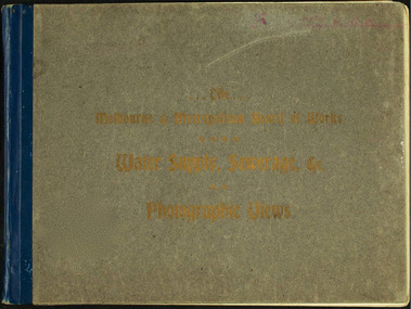
Photographic View Book, The Melbourne & Metropolitan Board of Works - Water Supply, Sewerage etc. ...Photographic Views, 1908
... Melbourne Water 990 La Trobe Street Docklands melbourne In 1891 The Melbourne and Metropolitan Board of Works (MMBW) was formed and became responsible for Melbourne's water supply. ...In 1891 The Melbourne and Metropolitan Board of Works (MMBW) was formed and became responsible for Melbourne's water supply. Melbourne had grown to a city of half a million people. To provide water to this rapidly growing city (especially the eastern suburbs), and to supplement the 1857 Yan Yean Reservoir, Melbourne's first water supply, the Watts River (near Healesville) was tapped. It supplied water to Melbourne, via the Maroondah aqueduct. In May 1892 the MMBW's first engineer-in-chief, Mr William Thwaites began construction on Melbourne's sewerage system. A treatment farm was built at Werribee and a pumping station was built at Spotswood (now the site of the Scienceworks Museum) to send the city's waste to Werribee. The first Melbourne homes were connected to the sewerage system in 1897. This book showcases the MMBW's infrastructure achievements and documents costs, requirements and key personnel involved in the development of the water supply and sewerage schemes.The introduction states "The water supply sources and headworks are in many cases situated in remote places and the sewerage works are chiefly underground. The Board has therefore resolved that these photographs of some of the scenes and works should be collected and bound for general information. August 1908" This book is in excellent condition and provides a detailed insight into the previous 17 years of work and the Board personnel of the MMBW leading up to 1908. It is of historical importance to the history of Melbourne for the photographic documents of places that were not generally open to the public, and for Melbourne Water in its detailed history of the MMBW in the early twentieth century. Photographic view book with hard khaki coloured cardboard cover and blue fabric binding. 120 Pages. Glossy paper with black and white plates and text about the MMBW, and scenic views and places of interest in association with the MMBW. The Melbourne & Metropolitan Board of Works - Water Supply, Sewerage etc. ...Photographic Views...mmbw, board members, sewerage, water supply, historic views, photographs -
 Melbourne Water
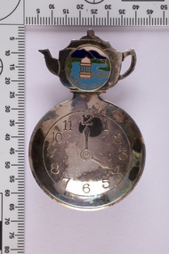
Souvenir tea caddy spoon "Tea Time", Early 1960s
... Melbourne Water 990 La Trobe Street Docklands melbourne Melbourne Water inherited many of its water assets, such as reservoirs from its predecessor the Melbourne Metropolitan Board of Works (MMBW). ...Melbourne Water inherited many of its water assets, such as reservoirs from its predecessor the Melbourne Metropolitan Board of Works (MMBW). They have served the organisation well and have long been celebrated for both their natural beauty and engineering ingenuity. In the nineteenth century Victoria’s fundamental need for water infrastructure went beyond merely functional solutions and reflected the English ideal of the romance and beauty that was embodied in expanses of water. The MMBW further enhanced this notion by incorporating beauty and function in to the Classical and Italianate designs of its infrastructure such as pumping houses and reservoir outlet towers. The reservoir gardens and picnic areas were landscaped with ornamental stonework, exotic trees, decorative flower beds, fern glads pools and rose gardens. All features of the water supply system became widely celebrated as beauty spots that continue to be very popular to this day with tourists and locals alike. This souvenir is a product of that flourishing tourist trade. These water supply sites continue to enhance Melbourne’s charm and liveability and are now recognised as places of cultural and historic significance This souvenir item has been curated by Melbourne Water as it represents an important historical aspect of the organisation by demonstrating the popularity of its water asset sites as recreational places and tourist attractions, and although these sites are functional parts of the water supply system, they were also designed to be enjoyed by the public both aesthetically and recreationally. Tea caddy spoon with clock face engraved showing 4pm on round spoon, tea pot shaped handle with enamel scenic view badge saying 'Healesville' ( depicting Maroondah Reservoir outlet tower). Tea caddy spoon box labelled 'Fine Silverware by Stokes'Stokes and Sons Stokes & Sons logo (Star with S and boomerang) EG. No. 15733melbourne metropolitan board of works, mmbw, maroondah reservoir, melbourne water, scenic view, souvenir, tea caddy spoon -
 Melbourne Water
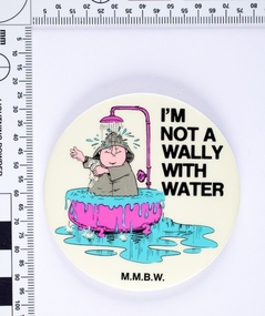
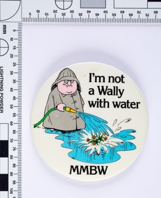
I'm not a Wally with Water badge, 1980s
... Melbourne Water 990 La Trobe Street Docklands melbourne Following the 1983 Victorian drought The Board of Works (MMBW) ran a television, radio and print campaign to encourage water conservation called ‘Don’t Be a Wally with Water’. ...Following the 1983 Victorian drought The Board of Works (MMBW) ran a television, radio and print campaign to encourage water conservation called ‘Don’t Be a Wally with Water’. The campaign followed Wally, a bumbling, habitual water waster, and is an early example of educating the public on water sustainability both environmentally and financially. Wally was both a cartoon character and played on television by the comedian Peter Moon. The campaign ran for several years and was designed to change attitudes towards water wastage. This MMBW branded item is associated with ‘Don’t Be a Wally with Water’ campaign, and demonstrates an early water sustainability education program. These badges would have been given out as promotional merchandise and at public events. Round metal badge with printed cartoon image and text. -
 Melbourne Water
Souvenir Manicure Set, ELOSI, Maroondah Dam, Healesville Souvenir, c.1940
... Melbourne Water 990 La Trobe Street Docklands melbourne The Maroondah System was first and foremost developed as a functional component of Melbourne's Water Supply System. In addition to functionality, the Melbourne and Metropolitan Board of Works (MMBW) envisioned the Maroondah Reserve to be enjoyed aesthetically and recreationally by the public. ...The Maroondah System was first and foremost developed as a functional component of Melbourne's Water Supply System. In addition to functionality, the Melbourne and Metropolitan Board of Works (MMBW) envisioned the Maroondah Reserve to be enjoyed aesthetically and recreationally by the public. This souvenir illustrates the realisation of the Maroondah System as a local recreational and tourist attraction in the early 20th century. The Maroondah Reserve gardens were landscaped with English-style ornamental stonework, exotic trees, flower beds and rose gardens. All features of the water supply system became widely celebrated as beauty spots that continue to be very popular to this day with tourists and locals alike. This souvenir is a product of that flourishing tourist trade. These water supply sites continue to enhance Melbourne’s charm and liveability and are now recognised as places of cultural and historic significance.This souvenir item has been curated by Melbourne Water as it represents an important historical aspect of the organisation by demonstrating the popularity of its water asset sites as recreational places and tourist attractions, and although these sites are functional parts of the water supply system, they were also designed to be enjoyed by the public both aesthetically and recreationally. This rare pocket grooming kit features a scene of the Maroondah Outlet and Dam. The handle is manufactured from mother-of-pearl, encasing four steel utensils. The utensils contained inside the kit were used for filing and manicuring.Engraved on the back of the last utensil is the manufacturer’s mark “ELOSI”. ELOSI is the acronym from Ernest Lohr and Otto Stiehl of Solingen, Germany. In 1935, this company was the first to manufacture thin plastic covers for low cost (5-25 cents). This is one of the most successful and profitable inventions in the history of cutlery and utensils.melbourne metropolitan board of works, mmbw, maroondah, dam, healesville, melbourne water, scenic view, souvenir, manicureset, historic, germany, rare -
 Melbourne Water
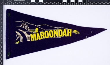
Souvenir Pennant
... Melbourne Water 990 La Trobe Street Docklands melbourne The Maroondah System was first and foremost developed as a functional component of Melbourne's Water Supply System. In addition to functionality, the Melbourne and Metropolitan Board of Works (MMBW) envisioned the Maroondah Reserve to be enjoyed aesthetically and recreationally by the public. ...The Maroondah System was first and foremost developed as a functional component of Melbourne's Water Supply System. In addition to functionality, the Melbourne and Metropolitan Board of Works (MMBW) envisioned the Maroondah Reserve to be enjoyed aesthetically and recreationally by the public. This souvenir illustrates the realisation of the Maroondah System as a local recreational and tourist attraction in the early 20th century. The Maroondah Reserve gardens were landscaped with English-style ornamental stonework, exotic trees, flower beds and rose gardens. All features of the water supply system became widely celebrated as beauty spots that continue to be very popular to this day with tourists and locals alike. This souvenir is a product of that flourishing tourist trade. These water supply sites continue to enhance Melbourne’s charm and liveability and are now recognised as places of cultural and historic significance.This souvenir item has been curated by Melbourne Water as it represents an important historical aspect of the organisation by demonstrating the popularity of its water asset sites as recreational places and tourist attractions, and although these sites are functional parts of the water supply system, they were also designed to be enjoyed by the public both aesthetically and recreationally. Navy in colour, the pennant is double sided, with an image of the Maroondah Dam surrounding the word “Maroondah” on both sides.melbourne metropolitan board of works, mmbw, maroondah, dam, healesville, melbourne water, scenic view, souvenir, pennant, flag, textile, historic -
 Melbourne Water
I'm not a Wally with Water badge, 1980s
... Melbourne Water 990 La Trobe Street Docklands melbourne Following the 1983 Victorian drought The Board of Works (MMBW) ran a television, radio and print campaign to encourage water conservation called "Don't Be a Wally with Water". ...Following the 1983 Victorian drought The Board of Works (MMBW) ran a television, radio and print campaign to encourage water conservation called "Don't Be a Wally with Water". The campaign followed Wally, a bumbling, habitual water waster, and is an early example of educating the public on water sustainability both environmentally and financially. Wally was both a cartoon character and played on television by the comedian Peter Moon. The campaign ran for several years and was designed to change attitudes towards water wastage.This MMBW branded item is associated with "Don't Be a Wally with Water" campaign, and demonstrates an early water sustainability education program. These badges would have been given out as promotional merchandise and at public events.Round metal badge with printed cartoon image and text. -
 Melbourne Water
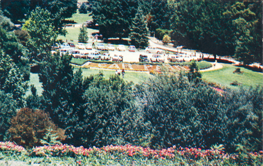
Postcard, The Car Park at Maroondah Reserve, c.1940
... Melbourne Water 990 La Trobe Street Docklands melbourne The Maroondah System was first and foremost developed as a functional component of Melbourne's Water Supply System. In addition to functionality, the Melbourne and Metropolitian Board of Works (MMBW) envisioned the Maroondah Reserve to be enjoyed aestethically and recreationally by the public. ...The Maroondah System was first and foremost developed as a functional component of Melbourne's Water Supply System. In addition to functionality, the Melbourne and Metropolitian Board of Works (MMBW) envisioned the Maroondah Reserve to be enjoyed aestethically and recreationally by the public. This souvenir postcard illustrates the realisation of the Maroondah System as a local recreational and tourist attraction in the early 20th century. The Maroondah Reserve gardens were landscaped with English-style ornamental stonework, exotic trees, flower beds and rose gardens. All features of the water supply system became widely celebrated as beauty spots that continue to be very popular to this day with tourists and locals alike. This souvenir is a product of that flourishing tourist trade. These water supply sites continue to enhance Melbourne’s charm and liveability and are now recognised as places of cultural and historic significance.This souvenir item represents an important historical aspect of the MMBW by demonstrating the popularity of its water asset sites as recreational places and tourist attractions, and although these sites are functional parts of the water supply system, they were also designed to be enjoyed by the public both aesthetically and recreationally. The souvenir postcard is significant for its documentation of the Maroondah Water Supply System developed through the late nineteenth and early twentieth century, shaping the formative years of Melbourne. The postcard is also historically significant for its association with the MMBW and is viewed as a noteworthy achievement of the organisation. Souvenir coloured rectangular postcard with a framed picture of the carpark at the Maroondah Reserve.melbourne metropolitan board of works, mmbw, maroondah reservoir, melbourne water, scenic view, souvenir -
 Melbourne Water
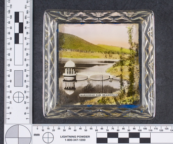
Dish, The Outlet at Maroondah Dam, Souvenir, c.1940
... Melbourne Water 990 La Trobe Street Docklands melbourne The Maroondah System was first and foremost developed as a functional component of Melbourne's Water Supply System. In addition to functionality, the Melbourne and Metropolitan Board of Works (MMBW) envisioned the Maroondah Reserve to be enjoyed aesthetically and recreationally by the public. ...The Maroondah System was first and foremost developed as a functional component of Melbourne's Water Supply System. In addition to functionality, the Melbourne and Metropolitan Board of Works (MMBW) envisioned the Maroondah Reserve to be enjoyed aesthetically and recreationally by the public. This souvenir dish illustrates the realisation of the Maroondah System as a local recreational and tourist attraction in the early 20th century. The Maroondah Reserve gardens were landscaped with English-style ornamental stonework, exotic trees, flower beds and rose gardens. All features of the water supply system became widely celebrated as beauty spots that continue to be very popular to this day with tourists and locals alike. This souvenir is a product of that flourishing tourist trade. These water supply sites continue to enhance Melbourne’s charm and liveability and are now recognised as places of cultural and historic significance.This souvenir item represents an important historical aspect of the MMBW by demonstrating the popularity of its water asset sites as recreational places and tourist attractions, and although these sites are functional parts of the water supply system, they were also designed to be enjoyed by the public both aesthetically and recreationally. The souvenir dish is significant for its documentation of the Maroondah Water Supply System developed through the late nineteenth and early twentieth century, shaping the formative years of Melbourne. The dish is also historically significant for its association with the MMBW and is viewed as a noteworthy achievement of the organisation.Small white porcelain dish with silver trim, 120x75x10mm, with drawing printed in the centre and text reading, "The Outlet, Maroondah Dam, Healesville, Vic." Makers mark, Manufactured in Czechoslovakiamelbourne metropolitan board of works, mmbw, maroondah, outlet, melbourne water, scenic view, souvenir, porcelain, healesville -
 Melbourne Water
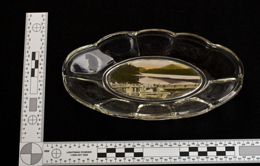
Glass Bowl, Maroondah Dam, Healesville Souvenir, 1930s -1940s
... Melbourne Water 990 La Trobe Street Docklands melbourne The Maroondah System was first and foremost developed as a functional component of Melbourne's Water Supply System. In addition to functionality, the Melbourne and Metropolitan Board of Works (MMBW) envisioned the Maroondah Reserve to be enjoyed aesthetically and recreationally by the public. ...The Maroondah System was first and foremost developed as a functional component of Melbourne's Water Supply System. In addition to functionality, the Melbourne and Metropolitan Board of Works (MMBW) envisioned the Maroondah Reserve to be enjoyed aesthetically and recreationally by the public. This souvenir illustrates the realisation of the Maroondah System as a local recreational and tourist attraction in the early 20th century. The Maroondah Reserve gardens were landscaped with English-style ornamental stonework, exotic trees, flower beds and rose gardens. All features of the water supply system became widely celebrated as beauty spots that continue to be very popular to this day with tourists and locals alike. This souvenir is a product of that flourishing tourist trade. These water supply sites continue to enhance Melbourne’s charm and liveability and are now recognised as places of cultural and historic significance.This souvenir item has been curated by Melbourne Water as it represents an important historical aspect of the organisation by demonstrating the popularity of its water asset sites as recreational places and tourist attractions, and although these sites are functional parts of the water supply system, they were also designed to be enjoyed by the public both aesthetically and recreationally. Clear glass flower shaped 'depression ware' bowl with photograph of Maroondah Dam Healesville in the base.melbourne metropolitan board of works, mmbw, maroondah reservoir, melbourne water, scenic view, souvenir, glass, bowl -
 Melbourne Water
Glass Bowl, Maroondah Dam, Healesville Souvenir, 1930s - 1940s
... Melbourne Water 990 La Trobe Street Docklands melbourne The Maroondah System was first and foremost developed as a functional component of Melbourne's Water Supply System. In addition to functionality, the Melbourne and Metropolitan Board of Works (MMBW) envisioned the Maroondah Reserve to be enjoyed aesthetically and recreationally by the public. ...The Maroondah System was first and foremost developed as a functional component of Melbourne's Water Supply System. In addition to functionality, the Melbourne and Metropolitan Board of Works (MMBW) envisioned the Maroondah Reserve to be enjoyed aesthetically and recreationally by the public. This souvenir illustrates the realisation of the Maroondah System as a local recreational and tourist attraction in the early 20th century. The Maroondah Reserve gardens were landscaped with English-style ornamental stonework, exotic trees, flower beds and rose gardens. All features of the water supply system became widely celebrated as beauty spots that continue to be very popular to this day with tourists and locals alike. This souvenir is a product of that flourishing tourist trade. These water supply sites continue to enhance Melbourne’s charm and liveability and are now recognised as places of cultural and historic significance.This souvenir item has been curated by Melbourne Water as it represents an important historical aspect of the organisation by demonstrating the popularity of its water asset sites as recreational places and tourist attractions, and although these sites are functional parts of the water supply system, they were also designed to be enjoyed by the public both aesthetically and recreationally. Glass bowl with a photograph of the Maroondah Dam in the middle, and text overlay reading "Maroondah Dam, Healesville". melbourne metropolitan board of works, mmbw, maroondah, dam, healesville, melbourne water, scenic view, souvenir, glass bowl -
 Melbourne Water
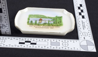
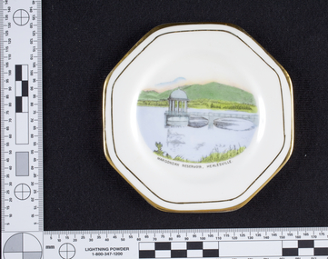
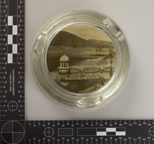
Dish, Maroondah Reservoir, Healesville Souvenir, 1930s-1940s
... Melbourne Water 990 La Trobe Street Docklands melbourne The Maroondah System was first and foremost developed as a functional component of Melbourne's Water Supply System. In addition to functionality, the Melbourne and Metropolitan Board of Works (MMBW) envisioned the Maroondah Reserve to be enjoyed aesthetically and recreationally by the public. ...The Maroondah System was first and foremost developed as a functional component of Melbourne's Water Supply System. In addition to functionality, the Melbourne and Metropolitan Board of Works (MMBW) envisioned the Maroondah Reserve to be enjoyed aesthetically and recreationally by the public. This souvenir illustrates the realisation of the Maroondah System as a local recreational and tourist attraction in the early 20th century. The Maroondah Reserve gardens were landscaped with English-style ornamental stonework, exotic trees, flower beds and rose gardens. All features of the water supply system became widely celebrated as beauty spots that continue to be very popular to this day with tourists and locals alike. This souvenir is a product of that flourishing tourist trade. These water supply sites continue to enhance Melbourne’s charm and liveability and are now recognised as places of cultural and historic significance.Manufactured in England, this souvenir dish made from bone china with gold trim, features an illustration of the Maroondah Reservoir in the centre reading, “Maroondah Reservoir, Healesville”. On the back of the dish is the makers mark, Royal Stafford, one of the oldest pottery factories in Staffordshire, England. The Royal Stafford brand was established in 1845 and continues to provide high quality tableware in the present day. This souvenir item has been curated by Melbourne Water as it represents an important historical aspect of the organisation by demonstrating the popularity of its water asset sites as recreational places and tourist attractions, and although these sites are functional parts of the water supply system, they were also designed to be enjoyed by the public both aesthetically and recreationally. Souvenir dish made from bone china with gold trim, featuring an illustration of the Maroondah Reservoir in the centre reading, “Maroondah Reservoir, Healesville”.Makers mark, Royal Stafford.maroondah, healesville, dish, porcelain, melbourne metropolitan board of works, melbourne water, mmbw -
 Melbourne Water
Ashtray, Graceburn Weir, Healesville Souvenir, 1930s-1940s
... Melbourne Water 990 La Trobe Street Docklands melbourne The Maroondah System was first and foremost developed as a functional component of Melbourne's Water Supply System. In addition to functionality, the Melbourne and Metropolitan Board of Works (MMBW) envisioned the Maroondah Reserve to be enjoyed aesthetically and recreationally by the public. ...The Maroondah System was first and foremost developed as a functional component of Melbourne's Water Supply System. In addition to functionality, the Melbourne and Metropolitan Board of Works (MMBW) envisioned the Maroondah Reserve to be enjoyed aesthetically and recreationally by the public. This souvenir illustrates the realisation of the Maroondah System as a local recreational and tourist attraction in the early 20th century. The Maroondah Reserve gardens were landscaped with English-style ornamental stonework, exotic trees, flower beds and rose gardens. All features of the water supply system became widely celebrated as beauty spots that continue to be very popular to this day with tourists and locals alike. This souvenir is a product of that flourishing tourist trade. These water supply sites continue to enhance Melbourne’s charm and liveability and are now recognised as places of cultural and historic significance.This souvenir item has been curated by Melbourne Water as it represents an important historical aspect of the organisation by demonstrating the popularity of its water asset sites as recreational places and tourist attractions, and although these sites are functional parts of the water supply system, they were also designed to be enjoyed by the public both aesthetically and recreationally.This Souvenir glass ashtray, used as a receptacle for ash from cigarettes, features a photograph of the Graceburn Weir on the base, with text reading “The Graceburn Weir, Healesville”. Rather small in size, this ashtray has a unique shape with four protruding glass points to place cigarettes. melbourne metropolitan board of works, mmbw, maroondah, dam, healesville, melbourne water, scenic view, souvenir, glass, ashtray, graceburnweir -
 Melbourne Water
Ashtray, Maroondah Dam, Healesville Souvenir, 1930s-1940s
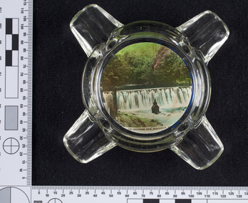
... Melbourne Water 990 La Trobe Street Docklands melbourne The Maroondah System was first and foremost developed as a functional component of Melbourne's Water Supply System. In addition to functionality, the Melbourne and Metropolitan Board of Works (MMBW) envisioned the Maroondah Reserve to be enjoyed aesthetically and recreationally by the public. ...The Maroondah System was first and foremost developed as a functional component of Melbourne's Water Supply System. In addition to functionality, the Melbourne and Metropolitan Board of Works (MMBW) envisioned the Maroondah Reserve to be enjoyed aesthetically and recreationally by the public. This souvenir illustrates the realisation of the Maroondah System as a local recreational and tourist attraction in the early 20th century. The Maroondah Reserve gardens were landscaped with English-style ornamental stonework, exotic trees, flower beds and rose gardens. All features of the water supply system became widely celebrated as beauty spots that continue to be very popular to this day with tourists and locals alike. This souvenir is a product of that flourishing tourist trade. These water supply sites continue to enhance Melbourne’s charm and liveability and are now recognised as places of cultural and historic significance.This souvenir item has been curated by Melbourne Water as it represents an important historical aspect of the organisation by demonstrating the popularity of its water asset sites as recreational places and tourist attractions, and although these sites are functional parts of the water supply system, they were also designed to be enjoyed by the public both aesthetically and recreationally. This Souvenir glass ashtray, used as a receptacle for ash from cigarettes, features a black and white photograph of The Maroondah Dam on the base, with text reading “Maroondah Dam, Healesville”. The ashtray is round in shape with three indents on the rim to place cigarettes. melbourne metropolitan board of works, mmbw, maroondah, dam, healesville, melbourne water, scenic view, souvenir, glass, ashtray -
 Melbourne Water
Maroondah, Healesville Souvenir Car Sticker
... Melbourne Water 990 La Trobe Street Docklands melbourne The Maroondah System was first and foremost developed as a functional component of Melbourne's Water Supply System. In addition to functionality, the Melbourne and Metropolitan Board of Works (MMBW) envisioned the Maroondah Reserve to be enjoyed aesthetically and recreationally by the public. ...The Maroondah System was first and foremost developed as a functional component of Melbourne's Water Supply System. In addition to functionality, the Melbourne and Metropolitan Board of Works (MMBW) envisioned the Maroondah Reserve to be enjoyed aesthetically and recreationally by the public. This souvenir illustrates the realisation of the Maroondah System as a local recreational and tourist attraction in the early 20th century. The Maroondah Reserve gardens were landscaped with English-style ornamental stonework, exotic trees, flower beds and rose gardens. All features of the water supply system became widely celebrated as beauty spots that continue to be very popular to this day with tourists and locals alike. This souvenir is a product of that flourishing tourist trade. These water supply sites continue to enhance Melbourne’s charm and liveability and are now recognised as places of cultural and historic significance.This souvenir item has been curated by Melbourne Water as it represents an important historical aspect of the organisation by demonstrating the popularity of its water asset sites as recreational places and tourist attractions, and although these sites are functional parts of the water supply system, they were also designed to be enjoyed by the public both aesthetically and recreationally. Souvenir car sticker with a colourful design of Maroondah Dam in Healesville with car sticker instructions.melbourne metropolitan board of works, mmbw, maroondah, dam, healesville, melbourne water, scenic view, souvenir, sticker, car, instructions -
 Melbourne Water
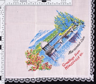
Handkerchief, Maroondah Dam, Healesville Souvenir, 1970s
... Melbourne Water 990 La Trobe Street Docklands melbourne The Maroondah System was first and foremost developed as a functional component of Melbourne's Water Supply System. In addition to functionality, the Melbourne and Metropolitan Board of Works (MMBW) envisioned the Maroondah Reserve to be enjoyed aesthetically and recreationally by the public. ...The Maroondah System was first and foremost developed as a functional component of Melbourne's Water Supply System. In addition to functionality, the Melbourne and Metropolitan Board of Works (MMBW) envisioned the Maroondah Reserve to be enjoyed aesthetically and recreationally by the public. This souvenir illustrates the realisation of the Maroondah System as a local recreational and tourist attraction in the early 20th century. The Maroondah Reserve gardens were landscaped with English-style ornamental stonework, exotic trees, flower beds and rose gardens. All features of the water supply system became widely celebrated as beauty spots that continue to be very popular to this day with tourists and locals alike. This souvenir is a product of that flourishing tourist trade. These water supply sites continue to enhance Melbourne’s charm and liveability and are now recognised as places of cultural and historic significance.This souvenir item has been curated by Melbourne Water as it represents an important historical aspect of the organisation by demonstrating the popularity of its water asset sites as recreational places and tourist attractions, and although these sites are functional parts of the water supply system, they were also designed to be enjoyed by the public both aesthetically and recreationally. Pink handkerchief with lace trim. The handkerchief features a print of the Maroondah Dam, with text “Maroondah Dam. Greetings from Healesville Vic”. melbourne metropolitan board of works, mmbw, maroondah, dam, healesville, melbourne water, scenic view, souvenir, handkerchief, pink, textile -
 Melbourne Water
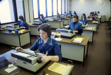
Photograph, Typists at the Board, August, 1977
... Melbourne Water 990 La Trobe Street Docklands melbourne As the Yarra became unsuitable as a source of water, several attempts were made to find alternative sources for the growing population of Melbourne. It was not until 1891 that the efforts to sewer Melbourne came to fruition with the setting up of the Melbourne Metropolitan Board of Works (MMBW), now known as Melbourne Water. ...As the Yarra became unsuitable as a source of water, several attempts were made to find alternative sources for the growing population of Melbourne. It was not until 1891 that the efforts to sewer Melbourne came to fruition with the setting up of the Melbourne Metropolitan Board of Works (MMBW), now known as Melbourne Water. From 1891 until 1992, it was the responsibility of the MMBW to safeguard public health by providing a sewerage system and a safe water supply system. In 1992, The MMBW merged with a number of smaller urban water authorities to form Melbourne Water. As the MMBW employed men to undertake secretarial work within the first few decades of operation, it wasn't until 1912 when the first female 'typiste' was employed. This photograph, showing a group of typists employed by the Board, is historically significant as it represents the kinds of jobs that women were employed in during the 1970s. Colour Photograph melbourne water, mmbw, melbourne metropolitan board of works, typists, women, administration -
 Melbourne Water
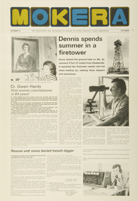
Staff Newsletter, Gwen Hardy, First Woman Commissioner, October, 1975
... Melbourne Water 990 La Trobe Street Docklands melbourne As the Yarra became unsuitable as a source of water, several attempts were made to find alternative sources for the growing population of Melbourne. It was not until 1891 that the efforts to sewer Melbourne came to fruition with the setting up of the Melbourne Metropolitan Board of Works (MMBW), now known as Melbourne Water. ...As the Yarra became unsuitable as a source of water, several attempts were made to find alternative sources for the growing population of Melbourne. It was not until 1891 that the efforts to sewer Melbourne came to fruition with the setting up of the Melbourne Metropolitan Board of Works (MMBW), now known as Melbourne Water. From 1891 until 1992, it was the responsibility of the MMBW to safeguard public health by providing a sewerage system and a safe water supply system. In 1992, The MMBW merged with a number of smaller urban water authorities to form Melbourne Water. Born on the 5th of August,1926, Margaret Gwen Hardy was the very first Commissioner of the Melbourne Metropolitan Board of Works (MMBW) and was appointed in 1975, a major victory for women at the time. This was the first time in the 84 year history of the organisation. Hardy had also been a Lilydale Councillor and went on to become the first female Shire President. Along with her work commitments as part of the Board, Hardy was the wife of Dr. Bill and had three children, two sons and a daughter. Next door to her home in Mt Evelyn was her husband’s surgery, where Hardy also worked part-time as a Manager. Hardy was also involved with the Lilydale High School Mother’s Club, she was the President of the Mt. Evelyn Environment Protection and Progress Association, on the Advisory Council of Monbulk High School and was the Secretary of the Lilydale Citizens Advisory Service at the time. This staff newsletter highlights the historically significant achievement of Cr. Gwen Hardy becoming the first female commissioner to work at the Board in 84 years. This captured achievement highlights women's career advancement at the MMBW and within the Victorian public service, whilst having historic and social associations with the many women's rights movements in the 1970s.comissioner, melbourne water, mmbw, melbourne metropolitan board of works, woman, staff, newsletter -
 Melbourne Water
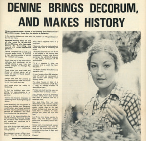
Staff Newsletter, Denine Moloney, First Female Apprentice Gardener, 1979
... Melbourne Water 990 La Trobe Street Docklands melbourne As the Yarra became unsuitable as a source of water, several attempts were made to find alternative sources for the growing population of Melbourne. It was not until 1891 that the efforts to sewer Melbourne came to fruition with the setting up of the Melbourne Metropolitan Board of Works (MMBW), now known as Melbourne Water. ...As the Yarra became unsuitable as a source of water, several attempts were made to find alternative sources for the growing population of Melbourne. It was not until 1891 that the efforts to sewer Melbourne came to fruition with the setting up of the Melbourne Metropolitan Board of Works (MMBW), now known as Melbourne Water. From 1891 until 1992, it was the responsibility of the MMBW to safeguard public health by providing a sewerage system and a safe water supply system. In 1992, The MMBW merged with a number of smaller urban water authorities to form Melbourne Water. Denine Moloney made history at the MMBW as the Board’s first female apprentice gardener, at the young age of 16. Denine was part of a team that cultivated and distributed up to 140,000 plants a year from the nursery complex that was housed on Warrigal Road, in Moorabbin. The large trees, shrubs and various other plants were all used in Board beautification projects. At the time, Denine lived with her parents and rode her bicycle to and from work each day while she attended Oakleigh Technical College one day a week as part of her apprenticeship. Denine’s ambition was to become a professional landscape gardener after her apprenticeship was completed, and four years later was in fact appointed as head gardener at Jells Park in 1983. Denine was not the last woman to work as a gardener at the Board, bringing with her two female assistants at Jells Park in caring, maintaining and distributing the Board’s horticulture. This staff newsletter highlights the significant achievement of Denine Moloney, becoming the first female gardener to work at the Board. This captured achievement highlights women's career advancement at the MMBW and within the Victorian public service, whilst having historic and social associations with the many women's rights movements of the 1970s.gardener, woman, melbourne metropolitan board of works, mmbw, staff, newsletter, 1970s -
 Melbourne Water
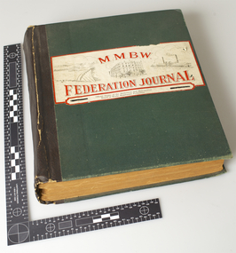
MMBW Federation Journal, October 1942 to May 1946
... Melbourne Water 990 La Trobe Street Docklands melbourne As the Yarra became unsuitable as a source of water, several attempts were made to find alternative sources for the growing population of Melbourne. It was not until 1891 that the efforts to sewer Melbourne came to fruition with the setting up of the Melbourne Metropolitan Board of Works (MMBW), now known as Melbourne Water. ...As the Yarra became unsuitable as a source of water, several attempts were made to find alternative sources for the growing population of Melbourne. It was not until 1891 that the efforts to sewer Melbourne came to fruition with the setting up of the Melbourne Metropolitan Board of Works (MMBW), now known as Melbourne Water. From 1891 until 1992, it was the responsibility of the MMBW to safeguard public health by providing a sewerage system and a safe water supply system. In 1992, The MMBW merged with a number of smaller urban water authorities to form Melbourne Water.Formally titled, The Official Organ of the Melbourne and Metropolitan Board of Works Employees’ Federation, this series is an exhaustive collection of monthly articles published by MMBW staff. This voluminous collection highlights the accomplishments and social agenda of MMBW employees throughout WWII and its impact on the organisation.mmbw, melbourne metropolitan board of works, journal, articles, staff, 1940s -
 Melbourne Water
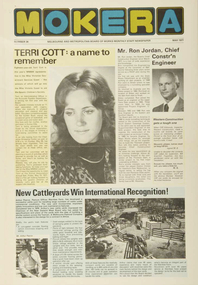
Staff Newsletter, Miss MMBW, Terri Cott, 1977
... Melbourne Water 990 La Trobe Street Docklands melbourne As the Yarra became unsuitable as a source of water, several attempts were made to find alternative sources for the growing population of Melbourne. It was not until 1891 that the efforts to sewer Melbourne came to fruition with the setting up of the Melbourne Metropolitan Board of Works (MMBW), now known as Melbourne Water. ...As the Yarra became unsuitable as a source of water, several attempts were made to find alternative sources for the growing population of Melbourne. It was not until 1891 that the efforts to sewer Melbourne came to fruition with the setting up of the Melbourne Metropolitan Board of Works (MMBW), now known as Melbourne Water. From 1891 until 1992, it was the responsibility of the MMBW to safeguard public health by providing a sewerage system and a safe water supply system. In 1992, The MMBW merged with a number of smaller urban water authorities to form Melbourne Water. The Australian Cerebral Palsy Association ran the Miss Australia Quest and had various titles such as Miss Queensland and Miss Victoria. One branch of the Victorian state competition was the Miss Victorian Government Service Quest. Terri Cott was one of the MMBW’s most popular representatives in the running for the title of Miss Victorian Government Service Quest in 1977. At the time, 18 year old Terri was an Administrative Officer in the Accounts Payable Department and had been with the Board for a year. Terri was crowned as the winner for Miss Victorian Government Service as she was the second highest money raiser with $17,337.72. This also won her a holiday on Brampton Island. Terri was up against 12 other women from other state Government Departments.This staff newsletter highlights the historically significant achievement of Miss Terri Cott being one of the most popular representatives in the running for the title of Miss Victorian Government Service Quest in 1977. This captured achievement not only focuses on Terri's external beauty, but demonstrates her charitable efforts. This newsletter article has historic and social associations with the many women's rights movements in the 1970s. In particular, it relates to the number of challenges the Miss Australia Quest experienced with feminist and activist groups threatening the future of the competition, which forced organisers to examine the appropriateness of the Quest. mmbw, melbourne water, miss mmbw, 1970s, staff -
 Melbourne Water
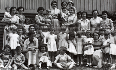
Photograph, Upper Yarra Dam Personnel, 1955
... Melbourne Water 990 La Trobe Street Docklands melbourne As the Yarra became unsuitable as a source of water, several attempts were made to find alternative sources for the growing population of Melbourne. It was not until 1891 that the efforts to sewer Melbourne came to fruition with the setting up of the Melbourne Metropolitan Board of Works (MMBW), now known as Melbourne Water. ...As the Yarra became unsuitable as a source of water, several attempts were made to find alternative sources for the growing population of Melbourne. It was not until 1891 that the efforts to sewer Melbourne came to fruition with the setting up of the Melbourne Metropolitan Board of Works (MMBW), now known as Melbourne Water. From 1891 until 1992, it was the responsibility of the MMBW to safeguard public health by providing a sewerage system and a safe water supply system. In 1992, The MMBW merged with a number of smaller urban water authorities to form Melbourne Water. In 1946, the Melbourne and Metropolitan Board of Works (MMBW) approved a site for a new dam for Melbourne's domestic water. This is now known as the Upper Yarra Dam. Due to the construction of the dam, the workforce had to be accommodated on site; domestic quarters were built for single men, families and staff. The township also had kitchens, laundry facilities, a canteen, a recreation hall, mess areas and a co-op store, with one of the first houses being seconded to accommodate for a school. This photograph shows personnel at a Kindergarten party at the Upper Yarra Dam, a time where workers were housed during its construction. The photograph is historically significant as it captures a purpose built community that supported the workers undertaking the construction of the dam. upper yarra dam, mmbw, melbourne metropolitan board of works, township, 1940s, community -
 Melbourne Water
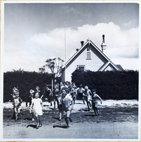
Photograph, North Cocoroc State Primary School, 1950s
... Melbourne Water 990 La Trobe Street Docklands melbourne As the Yarra became unsuitable as a source of water, several attempts were made to find alternative sources for the growing population of Melbourne. It was not until 1891 that the efforts to sewer Melbourne came to fruition with the setting up of the Melbourne Metropolitan Board of Works (MMBW), now known as Melbourne Water. ...As the Yarra became unsuitable as a source of water, several attempts were made to find alternative sources for the growing population of Melbourne. It was not until 1891 that the efforts to sewer Melbourne came to fruition with the setting up of the Melbourne Metropolitan Board of Works (MMBW), now known as Melbourne Water. From 1891 until 1992, it was the responsibility of the MMBW to safeguard public health by providing a sewerage system and a safe water supply system. In 1992, The MMBW merged with a number of smaller urban water authorities to form Melbourne Water. The township of Cocoroc was created in 1894 at the Metropolitan Sewage Farm (now the Western Treatment Plant) to house the workers it employed. The name 'Cocoroc' means 'frog' in the language of the Wathaurung people — the Traditional Owners of the land the treatment plant was built on. By the early 1950s there were nearly 100 houses, a town hall, football ground (and team), swimming pool, tennis courts, four schools and a post office, and by the 1970s some 500 people were living in Cocoroc. As it became too expensive for the MMBW to subsidise, Cocoroc was abandoned. By 1973 most of the houses and other buildings were demolished or moved to Werribee. All that is left now of Cocoroc are two small, empty, concrete swimming pools, a few weatherboard sheds and a big iron water tank. This photograph detailing an exterior view of the North Cocoroc State Primary School, is historically significant as it captures children at play within a purpose built community. The School that was one of four was built to educate the children of the MMBW workers. As the school no longer exists, this photograph is the only tangible evidence left of the building, also showcasing the style of buildings in this era. cocoroc, township, school, mmbw, melbourne metropolitan board of works, melbourne water -
 Melbourne Water
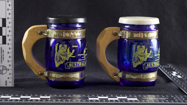
Souvenir Salt and Pepper Shakers, 1970s
... Melbourne Water 990 La Trobe Street Docklands melbourne The Maroondah System was first and foremost developed as a functional component of Melbourne's Water Supply System. In addition to functionality, the Melbourne and Metropolitan Board of Works (MMBW) envisioned the Maroondah Reserve to be enjoyed aesthetically and recreationally by the public. ...The Maroondah System was first and foremost developed as a functional component of Melbourne's Water Supply System. In addition to functionality, the Melbourne and Metropolitan Board of Works (MMBW) envisioned the Maroondah Reserve to be enjoyed aesthetically and recreationally by the public. This souvenir illustrates the realisation of the Maroondah System as a local recreational and tourist attraction in the early 20th century. The Maroondah Reserve gardens were landscaped with English-style ornamental stonework, exotic trees, flower beds and rose gardens. All features of the water supply system became widely celebrated as beauty spots that continue to be very popular to this day with tourists and locals alike. This souvenir is a product of that flourishing tourist trade. These water supply sites continue to enhance Melbourne’s charm and liveability and are now recognised as places of cultural and historic significance.These souvenir salt and pepper shakers have been curated by Melbourne Water as they represent an important historical aspect of the organisation by demonstrating the popularity of its water asset sites as recreational places and tourist attractions, and although these sites are functional parts of the water supply system, they were also designed to be enjoyed by the public both aesthetically and recreationally. Additionally, the salt and pepper shakers are aesthetically pleasing as the blue glass and wooden handles demonstrate the design and style of the 1970s. These souvenir salt and pepper shakers feature glass bodies, wooden handles and plastic lids. The salt and pepper shakers are decorated with pictures of koalas, kangaroos and a map of Australia. The text “Maroondah Dam, Vic” has been inscribed on the wooden handles.melbourne metropolitan board of works, mmbw, maroondah, salt and pepper shakers, souvenir, glass, healesville -
 Melbourne Water
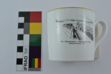
Souvenir Tea Cup, 1920s
... Melbourne Water 990 La Trobe Street Docklands melbourne The Maroondah System was first and foremost developed as a functional component of Melbourne's Water Supply System. In addition to functionality, the Melbourne and Metropolitan Board of Works (MMBW) envisioned the Maroondah Reserve to be enjoyed aesthetically and recreationally by the public. ...The Maroondah System was first and foremost developed as a functional component of Melbourne's Water Supply System. In addition to functionality, the Melbourne and Metropolitan Board of Works (MMBW) envisioned the Maroondah Reserve to be enjoyed aesthetically and recreationally by the public. This souvenir illustrates the realisation of the Maroondah System as a local recreational and tourist attraction in the early 20th century. The Maroondah Reserve gardens were landscaped with English-style ornamental stonework, exotic trees, flower beds and rose gardens. All features of the water supply system became widely celebrated as beauty spots that continue to be very popular to this day with tourists and locals alike. This souvenir is a product of that flourishing tourist trade. These water supply sites continue to enhance Melbourne’s charm and liveability and are now recognised as places of cultural and historic significance.This souvenir tea cup has been curated by Melbourne Water as it represents an important historical aspect of the organisation by demonstrating the popularity of its water asset sites as recreational places and tourist attractions, and although these sites are functional parts of the water supply system, they were also designed to be enjoyed by the public both aesthetically and recreationally. Additionally, the tea cup is aesthetically pleasing, representative of 1920s style and design. This porcelain tea cup with gold trim features a black and white image of the embankment at Maroondah Dam, Healesville on the front.melbourne metropolitan board of works, melbourne water, mmbw, porcelain, tea cup, maroondah, healesville -
 Melbourne Water
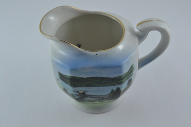
Souvenir Porcelain Milk Jug, 1910-1930
... Melbourne Water 990 La Trobe Street Docklands melbourne The Maroondah System was first and foremost developed as a functional component of Melbourne's Water Supply System. In addition to functionality, the Melbourne and Metropolitan Board of Works (MMBW) envisioned the Maroondah Reserve to be enjoyed aesthetically and recreationally by the public. ...The Maroondah System was first and foremost developed as a functional component of Melbourne's Water Supply System. In addition to functionality, the Melbourne and Metropolitan Board of Works (MMBW) envisioned the Maroondah Reserve to be enjoyed aesthetically and recreationally by the public. This souvenir illustrates the realisation of the Maroondah System as a local recreational and tourist attraction in the early 20th century. The Maroondah Reserve gardens were landscaped with English-style ornamental stonework, exotic trees, flower beds and rose gardens. All features of the water supply system became widely celebrated as beauty spots that continue to be very popular to this day with tourists and locals alike. This souvenir is a product of that flourishing tourist trade. These water supply sites continue to enhance Melbourne’s charm and liveability and are now recognised as places of cultural and historic significance.This souvenir milk jug has been curated by Melbourne Water as it represents an important historical aspect of the organisation by demonstrating the popularity of its water asset sites as recreational places and tourist attractions, and although these sites are functional parts of the water supply system, they were also designed to be enjoyed by the public both aesthetically and recreationally. Additionally, this item is aesthetically significant as it represents the style and design of the early 1900s.This souvenir white-glazed porcelain milk jug features gold trim and an illustration of the Maroondah Outlet in the centre, with the transfer “Maroondah Dam, Healesville, Vic”.