Showing 26553 items
matching weatherly-library
-
 Federation University Historical Collection
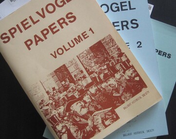
Booklets, Ballarat Historical Society, Spievogel Papers, volumes 1,2, & 3
Nathan Spielvogel was a local historian. The Spielvogel Papers consist of the articles he prepared for a series of weekly talks on Radio 3BA in 1936 and 1937. According to Alex Barnett there is a reference in the Spielvogel Papers to the moving of the bodies of diggers killed at the Eureka Stockade to the old cemetery on 26 November 1857.3 soft covered books with text relating to the history of Ballarat. .1) yellow cover .2) blue cover .3) green cover .1) includes topics such as Gold discovery, Eureka, Main Road, Ballarat Fire Brigade, Ballarat Benevolent Home, Buninyong, Burke and Wills Monument, Chinese in Ballarat, Dana Street School, Ballarat Hospital, Lost Trades of Ballarat, Ballarat Military, Mount Pleasant, Old Colonists' Club, Phoenix Foundry, Ballarat Post Office, Railways, Ballarat School of Mines, South Street Society, Martin Hosking, Charles Curnow Phillips, James Sainsbury, and William Cross Yuille. .2) includes topics such as Ballarat streets, bowls, cricket, football, hotels, Little Bendigo, Lake Wendouree, Ballarat Quartz Mines, Sebastopol, Ballarat Turf Club, Ballarat Zoo, water supply. .3) includes topics such as the Kohinoor Nugget, Eureka, Black Hill, Sebastopol, oddietown, Joe the bellman, Trades Hall, Lal Lal Iron, Ballarat Library, Yuille Creek, Martin Hosking, Stonewall Jackson, steeplechase, Lemonade Paddock, Ivey's Flour Mill, Salvation Army, Stick Jaw Davey, Unicorn Hotel, doctors, Alfred Bells, Ballarat School of Mines Museum (War Museum), Joseph Orange, Ballarat East Post Office.ballarat, speilvogel, nathan spielvogel -
 Federation University Historical Collection
Magazine, Ballarat School of Mines Students' Magazine, 1965, 1965
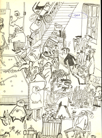
The editorial committee for the 1965 Ballarat School of Mines Student Magazine was Trevor Barnett, Gary Bunn, Roger Donaldson, Fred Evans, Ralph Fenney, Greg Hunter, Jon McDonald, Malcolm Park, Geoff Pollard, Gary Roberts, Peter Smith and John Thorne. In 1965 Morgan B. John was President of the Ballarat School of Mines, and the Principal was E.J. (Jack) Barker.White soft covered magazine of 91 pages with black line drawings and caricatures on the cover designed by Trevor Barnett. Articles include: The importance of Library Services, a list of Diplomas conferred and prizes presented, Camping Daze, The Civilising Influences of Mining, Jigging in Beds (bed race), Art School, Sed Education, War, Man's Neurotic flaw, National Service, In Man A Brute?, Journey into the Unknown, Philosophy of Games; Roll Call 1965. Snippits include: Trevor Barnett announced as the winner of the Eric Mcgrath Award for 1965; Wayne Johnson was awarded the Honour Blazer. The deaths of Noel Hooper, David Bell and Shane Carroll were recorded. Numerous black and white images but no name captions. Advertisements by Ronaldson and Tippett, Electrolytic Zinc Company of Australasia, BHP, Mount Isa Mines, Australuco Aluminium, Owen's of Ballarat. Alexandria Tea Rooms, Roy Bracks Mens Wear, A.J. Williams Electrical Equipment, Young Squire, H.B. Selby & Co., The Wattle, T.J. Coutts, H.A. Davis Motor Service, Henderson-Palmer, Philips Electrical, Myers, M.B. John & Hattersley Limited, Andrew Gault, Tait Book Company, BHAS, Morsheads, Commonwealth Aircrafts Corporation, J.J. Mortimer, Ewins, B. and G. Myers ballarat school of mines, roger donaldson, gary bunn, trevor barnett, noel hooper, david bell, shane carroll, vietnam war, national service, bracks slacks, fred evans, ralph fenney, greg hunter, jon mcdonald, malcolm park, geoff pollard, gary roberts, peter smith, john thorne -
 Eltham District Historical Society Inc
Folder, Eltham War Memorial Trust; Easter Gymkhana Committee Minutes, 19 Nov 1954-6 Jun 1958
Contents: Notice from Honoury Treasurer of Easter Gymkhana Committee regarding completion of 1954 event and expression of thanks and that committee is now going into recess prior to commencement of planning for 1955 Notice of Easter Gymkhana Committee Meeting, Monday 24th October, 1955 at the Shire Hall, Eltham Letter from B.T. Taylor, Hon. Secretary, Eltham Easter Show Committee regarding the sale of tickets (c.1957) Letter from B.T. Taylor, President, Eltham Easter Show Committee to Georges Ltd regarding the supply of The Georges Cup for the Eltham Easter Show, 11 April 1958 Letter from Georges Ltd to B.T. Taylor, President, Eltham Easter Show Committee with payment for the minitiares of The Georges Cup, 6 June 1958 Letter from Eltham Shire Secretary to B.T. Taylor, President, Eltham Easter Show Committee advising of new procxess regarding raffle, 5 May 1958 Letter from Lilian Heath, Secretary, Judge Book Village Auxiallary to B.T. Taylor, Eltham Easter Show Committee, 24 May 1958 Letter from Mrs R.J. Godfrey on behalf of M.A. Godfrey of Dandenong to B.T. Taylor, President, Eltham Easter Show under threat of legal action requesting replacement of cheque for £10 (second prize Open Jumping Contest), which was lost, 24 May 1958 Reply by B.T. Taylor, President, Eltham Easter Show Committee to Mrs R.J. Godfrey to her letter of 24 May explaining circumstances and denying responsibility to forward a replacement cheque as it was cashed at the Golf Club Hotel; 6 June 1958 History of the War Memorial Following the end of the First World War, communities across Victoria and Australia typically erected memorials which were predominantly statues, cenotaphs, avenues of honour and plaques. The Shire of Eltham established the Avenue of Honour at the gateway to the shire as well as an obelisk at the corner of Main Road and Bridge street and the Shire of Eltham War Memorial Tower at Kangaroo Ground. After the Second World War communities once again desired to preserve the memories of those who served and paid the ultimate sacrifice. Resources were scarce so there was a transition away from the traditional style memorials that sprang up post 1918 to one of building facilities that would provide ongoing benefit to the community. Even before the end of the Second World War, the citizens of Eltham began to consider an appropriate form of memorial for those from the area who fought and died in the First and Second World Wars. In 1943 the Eltham Women’s Auxiliary raised funds for the construction of buildings to be established on land to be purchased for the proposed War Memorial. On March 27th, 1945, the Eltham District Progress Association called a meeting of local people who in turn set up and registered the Eltham War Memorial Trust Inc. As a focus for the purpose of the memorial, the newspaper notice read:- ‘Those who have had a member of their family in the fighting services will want to see that the form of a memorial we are concerned with is the one which will be a constant reminder to us of those who fought for us and the little ones for whom they fought and died.’ At that meeting it was decided the Memorial should take the form of a baby health centre along with a creche and children’s library. In late 1945, the newly formed Eltham War Memorial Trust purchased the land at 903-907 Main Road Eltham from Miss Shillinglaw, which once formed part of the Shillinglaw farm on Lot 90 of Holloway’s 1851 “Little Eltham” subdivision. The Governor of Victoria, General Sir Dallas Brooks, laid the foundation stone on November 24th, 1950, in memory of those who fell in the Second World War. The Eltham Infant Welfare Centre was opened November 15th, 1952, the Pre-school on December 1st, 1956, and the Children’s Library in 1961. In late 1966 the children’s library service was integrated into the Heideberg Regional Library Service and the building was officially renamed the Eltham War Memorial Hall. Following the opening of the Eltham Infant Welfare Centre, work began in 1953 planning for the entrance to the grounds, which is signaled by a wrought iron arch entitled “Eltham War Memorial” . In 1954 the Eltham War Memorial Trust decided that a legacy provided by the late Councillor Ernest James Andrew (d. 29 March 1950) in memory of his wife, Mrs. Ellen Andrew (d. 13 July 1946) and who are both buried at Eltham Cemetery, should be used to fund the construction of the entrance. A metal plate inscribed to this effect was attached to the gates. Work on the Memorial Gardens was undertaken throughout the following decade, with a Memorial Forecourt included in the final 1956 plans for the Pre-School Centre. A quote was accepted by the Trust in 1963 for the implementation of a memorial garden, which included grading of a sixty-five foot strip at the rear of the Trust buildings and construction of concrete paths. The stone retaining walls at the front of the site were installed in 1968 when Main Road was widened and it is believed that the Memorial Gates were relocated at that time also. Eltham Senior Citizens Centre In 1964, Eltham Shire Council purchased a section of land from the Trust at the northern end of the site, as a provision for Country Fire Authority buildings. At the same time the Elderly Citizens Club proposed a Senior Citizens Centre on the south western section of the Trust’s property. This was approved by the Trust with the provision that the building was constructed in ‘accord’ with those already existing. In 1965 Council took on board the plans for the Senior Citizens Centre and applied for a government grant. These could only be awarded if Council owned the site. In 1962 the Trust had resolved to hand over the assets to Council once the Memorial Gardens were completed. This was in line with Health Department requirements that grants for the ongoing operation and maintenance of the three facilities would only be made once the the facilities were completed and handed over to Council. In 1965 the Department of Health further demanded substantial alterations to the Pre-School playground as a result of the pending impact of the planned Senior Citizens Centre and Main Road duplication. As a consequence, handover of the Trust’s assets to Council was initiated with a formal ceremony held in the Children’s Library on August 28th, 1965. The Trust continued on as a committee of management for another twelve months. Plans and specifications for the Senior Citizens Centre were prepared by March 1966. Council obtained a grant from the Government which covered one third of the cost and the building was completed by April 1967. Whilst the Senior Citizens Centre is contained within the original Eltham War Memorial building precinct, it was not part of the original Memorial and was not funded by the Eltham War Memorial Trust.Nine copies of letters/notices inserted loose in Minute Book, 33 x 21 x 1 cm, green faux crocodile skin hard board end-covers with black spine binding; 82 pages (last 38 blank)b.t. (ben) taylor, easter gymkhana committee, eltham war memorial trust, georges ltd, golf club hotel, judge book village auxilliary, lilian heath, minutes, r.j. godfrey, the georges cup -
 The Beechworth Burke Museum
Geological specimen - Feldspathic Sandstone
Feldspathic arenites are sandstones that contain less than 90% quartz, and more feldspar than unstable lithic fragments, and minor accessory minerals.Feldspathic sandstones are commonly immature or sub-mature.These sandstones occur in association with cratonic or stable shelf settings. Feldspathic sandstones are derived from granitic-type, primary crystalline, rocks. If the sandstone is dominantly plagioclase, then it is igneous in origin Sandstone features prominently in public buildings throughout Victoria. Most of the sandstone used as dimension stone in the State came from three sources: the Heatherlie quarry in the Grampians (Silurian), the Bacchus Marsh area (Permian), and the Barrabool Hills near Geelong (Cretaceous).Sandstone features prominently in public buildings throughout Victoria, making this specimen special as it shows the materials used by Victorian building companies. Sandstone can also be crushed, crushed stone is used in the construction of roadways and road structures such as bridges, and in buildings, both commercial and residential. This specimen is part of a larger collection of geological and mineral specimens collected from around Australia (and some parts of the world) and donated to the Burke Museum between 1868-1880. A large percentage of these specimens were collected in Victoria as part of the Geological Survey of Victoria that begun in 1852 (in response to the Gold Rush) to study and map the geology of Victoria. Collecting geological specimens was an important part of mapping and understanding the scientific makeup of the earth. Many of these specimens were sent to research and collecting organisations across Australia, including the Burke Museum, to educate and encourage further study. A feldspar-rich sandstone, a sandstone intermediate in composition between an arkosic sandstone and a quartz sandstone, containing 10% to 25% feldspar and less than 20% matrix material of clay, sericite, and chlorite. Feldspathic arenite containing less than 90 percent of the composition of quartz. Feldspar is the main composition. Feldspathic arenite may contain fragments of unstable rock, and a little amount of other minerals such as mica and heavy minerals. Some feldspathic arenite have pink or red color because of the presence of potassium feldspar or iron oxide. There are also colored light gray to white. These sandstones are usually medium to coarse grained and can contain a high percentage of granules with angular until subangular roundness. The content of the matrix can appear as the rest up to more than 15 percent, and sorting of grains can present as moderate to poorly sorted. Feldspathic sandstones are generally immature in textural maturity. Feldspathic arenite can not be judged from the structure of the sediment. Bedding can emerge from the laminate parallel to the crossbed. Fossils may appear in the layer deposited on the sea. Feldspathic arenites usually appear on the craton or the continental shelf, which can be associated with conglomerate, quartz lithic arenite, carbonate rock, or evaporites. This sandstone may also appear on the succession of sedimentary basins deposited on an unstable or deep sea, and moving arc setting. According to Pettijohn (1963) Arkose make up about 15 percent of all sandstones. Some Arkose formed in situ when the granite and related rocks disintegrate and generate granular sediments. Most of the material feldspathic sandstones derived from primary crystalline granitic rocks, such as granite or metasomatic rocks containing abundant potassium feldspar. Mineral contained in sandstones is mostly a form of plagioclase feldspar derived from quartz diorite or volcanic rock. Feldspar contained on this sandstone comes from arid to cool climates when the chemical weathering process is reduced.sandstone, natural stone, feldspathic sandstone, burke museum, geology, geological, geological specimen -
 Flagstaff Hill Maritime Museum and Village
Document - Plans, Lighthouse Keeper's Quarters Warrnambool, 1858-1909
The set of seven 1858 plans shows proposed plans for the original Lighthouse Complex that was built on Middle Island in 1858-1859. The whole complex was then transferred to Flagstaff Hill in 1871. The plan, dated 1909, is for proposed additions and repairs to the Quarters at Flagstaff Hill. The plan 'Alterations and Additions' shows alternate plans for changes to the quarters at the Flagstaff Hill location. This plan has no date. The Complex comprised the Lighthouse, the Lighthouse Keepers’ Quarters, the Store (now called the Chart Room) and a Privy, which was not included in these plans. The Keeper’s bluestone Quarters was a cottage divided into two compartments, one for each keeper and his family. The bluestone Store was divided into three; a store, a workshop an oil store (or office). The Privy comprised of a small building also divided into two separate, back-to-back toilets, one for each Keeper and his family. The Flagstaff Hill Keeper's Quarters have had extensions and additions at various times, and these have also been removed at various other times. THE PLANS - *Dec. 1858 (12/58) ‘Lighthouse Keepers Quarters No.2 Warrnambool’ (2375.01)* Public Works Office Melbourne – Front and Back elevations, sections, and floor plan. The drawing shows timber walls. [The floor plan is the closest plan to the current building, however, the walls are timber in this plan.] *Nov. 1858 – No.3 ‘Lighthouse Keepers Quarters Warrnambool’ (2375.02)* Office of Public Works, Melbourne – Back and End elevations and section through. The drawing shows stone walls. One side; Senior Keeper’s bedroom, living room and kitchen with storeroom. Another side; is the Assistant’s bedroom, living room and storeroom. *Nov. 1858 - No.4 ‘Lighthouse Stores Warrnambool’ (2375.03)* Office of Public Works – Front, Side and end elevations, centre section. The drawing shows stone walls. *Nov. 1858 – No.4, ‘Lighthouse Stores No. 2 Warrnambool’ (2375.04)* Office of Public Works – Front, side and end elevations, centre section. The drawing shows timber walls. *Nov. 1858 – ‘Details Lighthouse Keepers Quarters No. 2 Warrnambool’ (2375.05)* Public Works Office Melbourne. The plan shows the foundations, joists and eaves. The drawing shows timber walls. (Nov. 1858 – ‘No.4 ‘Lighthouse No. 2 – Warrnambool’ (2375.06)* Public Works Melbourne (Part of the paper is missing). This plan shows an octagonal tower, internal stairs, a balcony landing, and a weather vane on top. *November 1858 – No. 1, ‘Lighthouse – Warrnambool’ (2375.07)* Office of Public Works Melbourne. This plan shows a round tower, including the stairs, windows on the tower and the weather vane on the top. *4/3/9 [1909] – ‘Additions and Repairs, Lighthouse Quarters, Warrnambool, General Plan’ (2375.8)* Department of Public Works Melbourne’s official stamp is signed by Croft. It shows the floor plans of the Store, Upper Lighthouse and the Quarters. The Store building has three sections; a Store, Work-Shop and Office, with an internal wall between them and separate entries. The Quarters are divided into two dwellings. The Senior Keeper’s side on the left has fireplaces in two of the three bedrooms and there is a pantry and wash house. The Assistant’s side has no fireplaces in the bedrooms and there’s no pantry or washhouse. These plans include proposed changes to the buildings. The Senior Keeper’s Quarters would have a partition on bedroom 2, a bath with plumbing and drainage, a wall moved and a built-in side porch. The Store would also have a built-in porch. The undated plan 'Additions and Alterations' (2375.9) shows alternative arrangements for water tanks, plumbing and such. WARRNAMBOOL'S LADY BAY LIGHTHOUSES- In the 1800s ships sailing from England to Australia began to use Bass Strait as a faster route to Melbourne. Small navigation errors led to many tragic shipwrecks. From 1848 lighthouses were operating along Victoria’s southern coast as a guide for sailors. Coastal towns such as Warrnambool grew and the exchange of trade and passengers were of great benefit. However, the uncertain weather changes, relatively shallow waters and treacherous, hidden rocky reefs were not suitable for a Harbour and in the 1840s and 1850s there were many shipwrecks in the area, with some even stranded in its Lady Bay harbour. A jetty was built in 1850 and a flagstaff to guide seafarers was placed up high on what became known now as Flagstaff Hill. In November 1857 the Victorian Government recommended that Warrnambool Harbour had beacons and two lighthouses to guide vessels into and out of the Harbour safely. The white light of the Middle Island lighthouse was to be used for the first time on September 1, 1859. The red light of the Beach Lighthouse, a wooden obelisk structure, was first operated on March 25, 1860, but in 1868 this light was ‘discontinued’ due to it being too low. Melbourne’s Department of Public Works decided to relocate the Middle Island Lighthouse Complex - Lighthouse, Keeper’s Quarters, Privy, Store Room and even water tanks - to Flagstaff Hill. The lower obelisk was shortened, and a protruding gallery, railing, and external ladder were added, as well as the light from the Beach Lighthouse. A green guiding light was erected on the end of the jetty. The transfer of the Complex began in March 1871. Each shaped stone of the lighthouse was carefully numbered, removed then reassembled on Flagstaff Hill. In 1872 the well was sunk behind the Lighthouse Keeper’s Cottage. The Keepers and families had left Middle Island in April and moved to Flagstaff Hill in October 1871. Vessels entering Lady Bay align the Upper and Lower Lighthouse towers during the day and the lights at night. The Upper Lighthouse is a round tower, the Lower Light is square. The Lighthouses were categorised as harbour lights rather than coastal lights, so they remain under the control of the Victorian Government’s Ports and Harbours section. The lights were originally powered by oil, then acetylene gas, later by electricity, and then converted to solar power in 1988. In 1993 the solar panel was replaced by a battery charger. A decision was made in 1936 to replace the lighthouses’ lights with unattended lights that no longer required Keepers and Assistants. At least 29 Keepers had attended to the lighthouse from its opening in 1859 to when the last official Lightkeepers left In April 1916. The Warrnambool Harbour Board rented out the Quarters from 1916 to 1936. The Board closed down but the rentals continued with other unknown landlords. In the 1970s the Flagstaff Hill Planning Board was set up under the chairmanship of John Lindsay. The Board was to make recommendations to the Warrnambool City Council regarding the use of the buildings and the rest of the Crown Land on the site. The Flagstaff Hill Maritime Village opened in 1975 and began renovating the Cottage in stages, during which time evidence of a 1920s fire was found in the eastern section of the cottage. Additions of a porch on the west and a washroom on the east were made in the 1980s. The western part of the building is now a Shipwreck Museum and the east has returned to a late 19th-century Lighthouse Keeper’s cottage and includes the screen made by Assistant Lighthouse Keeper Thomas Hope during one of his two periods of service there. THE LIGHTHOUSE KEEPERS Lighthouse Keepers were responsible for keeping their Lighthouse’s lights shining at night. They kept a lookout for passing vessels and changes in weather. They were expected to clean, polish and maintain the equipment and buildings. They kept regular and detailed records of who was on watch, and the time the light was lit, trimmed and extinguished. They kept a journal about other events that occurred. They keep regular, accurate Meteorological Logs. It was expected that they were competent in Morse code signalling. They would be called to help in times of disasters and shipwrecks, and to give official statements about these events. Many Lighthouse Keepers also volunteered as members of the lifeboat crew. The Lady Bay lighthouses were officially classified as small, so the Keepers had the official titles of Senior Assistant Lighthouse Keeper and Assistant Lighthouse Keeper. They were employed by the Public Service and paid rent to live in the Lighthouse Quarters. They were compulsorily retired at the age of 60, with most receiving a superannuation payment. Despite their time-consuming duties, there was time to follow hobbies and crafts such as growing vegetables, playing musical instruments, making models of buildings including lighthouses, and crafting furniture pieces. An example of a keeper’s skills is the carved fire screen made by /assistant Keeper Thomas Hope in the early 20th century and displayed in the Lighthouse Keeper’s cottage at Flagstaff Hill. The last occupants of the Middle Island Complex were Senior Keeper Robert Deverell, his Assistant Keeper, Andrew Farncombe, and their families. They all became the first occupants at the Lady Bay Lighthouse Keepers’ Quarters on Merri Street. The Warrnambool Lighthouse Complex plans are the origin of what is now the Lady Bay Lighthouse Complex. They are a record of the people, process and departments involved in bringing the complex into fruition. The plans are significant to the Complex, which is now listed on the Victorian Heritage Register, H1520, for being of historical, scientific (technological) and architectural significance to the State of Victoria. The Complex is significant as an example of early colonial development. The plan are significant for their connection with the important navigational function of the Lighthouses, a function still being performed to this day. The plans are also significant as an example of a product from the Public Works Department in Victoria in the mid-to-late 19th century. The structures built to these plans still stand strong. Plans for the Lighthouse Complex in Warrnambool, including Lighthouses, Keeper's Quarters and Stores. Seven of the plans are on thin fragile paper, one is on thicker, stronger paper. The drawings have been made in pens coloured red and black. They originate from Public Works in Melbourne. Seven were drawn in 1858, one in 1904, the other is not dated.Dec. 1858 - Lighthouse Keepers Quarters No.2 Warrnambool. Public Works Office Melbourne. Nov. 1858 - No.3 ‘Lighthouse Keepers Quarters Warrnambool. Public Works Office Melbourne. Nov. 1858 - No.4 ‘Lighthouse Stores Warrnambool. Office of Public Works. Nov. 1858 - No.4, ‘Lighthouse Stores No. 2 Warrnambool. Office of Public Works. Nov. 1858 - Details Lighthouse Keepers Quarters No. 2 Warrnambool. Public Works Office Melbourne. Nov. 1858 - No.4 ‘Lighthouse No. 2 – Warrnambool. Public Works Melbourne. Nov. 1858 - No. 1, Lighthouse - Warrnambool. Office of Public Works Melbourne. 4/3/9 [1909] - Additions and Repairs, Lighthouse Quarters, Warrnambool, General Plan. Department of Public Works Melbourne. SIGNED "Croft" "15A" on reverse [no date] - Lighthouse Quarters Warrnambool, Additions and Alterations. "9A" on reverseflagstaff hill, warrnambool, lighthouse keeper's cottage, lighthouse residence, lighthouse, plans, public works, melbourne, flagstaff hill maritime museum, maritime museum, shipwreck coast, flagstaff hill maritime village, chart room, quarters, privy, middle island, beach lighthouse, obelisk, lighthouse keeper, assistant keeper, lighthouse complex, lady bay, lady bay complex, keepers, upper lighthouse, lower lighthouse, ports and harbours, cottage, harbour board, flagstaff hill planning board, meteorological record, robert deverell, andrew farncombe, warrnambool port, warrnambool harbour, residence, alterations, repairs, department of works -
 Flagstaff Hill Maritime Museum and Village
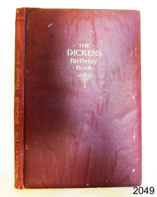
Book - Birthday Book, Raphael Tuck & Sons et al, The Dickens Birthday Book, 1901-1910
Birthday books are used to record the names and birth dates of friends and relatives. This one has a quote from Charles Dickens for each day of the year .The Dickins Birthday book was chosen a a gift to Clara Skirrow, given on January 19th 1911 by Mr and Mrs B Watson. The artist, Pilford Fletcher Watson (1892-1907) was a well established and prominent artist. He was born in London and lived in Sydney, a foundation member of the Australian Academy of Arts in 1887. His works included local scenery, architecture and the interiors of historic buildings. Many of his works were bequeathed to the State Library of New South Wales. The firm Raphael Tuck & Sons Ltd,, was a printer and publisher that operated in London from 1866 to circa 1960s. Its logo is the artist's easel, palette and brush. In 1960 the firm amalgamated with others to become the British Printing Corporation c. 1960. The fly page states that Ralph Tuck & Sons, Ltd. were publishers to Their Majesties, the King and Queen, and Their Royal Highnesses, the Prince and Princess of Wales. This would mean that this book was published in the period when King Edward VII and Queen Alexandra, and Prince George and his wife Princess Mary were able to use these titles, that is, from 1901 to 1910. This early 20th-century Birthday Book is significant for containing quotes by the famous writer Charles Dickins. It is also significant for being illustrated by renowned artist Pilford Fletcher Watson. Ownership of a rare and beautifully presented book like this indicates the value placed on keeping in touch with friends and family in the early 1900s. Charles Dickins Birthday books were published by the same firm, with a similar layout.Book, The Dickens Birthday Book; with 6 illustrations in Colour by P. Fletcher-Watson Publisher: Raphael Tuck & Sons Ltd Printed in England 1901-1910 Artist: P. Fletcher-Watson This padded red leather hardcover book has embossed gold text on front cover and spine. . The six colour illustrations throughout the book were by artist P. Fletcher-Watson; one is a portrait of Dickins. Each date of the year has a quotes from Charles Dickens' works and blank lines below. The drawing on the fly page depicts a stone building with side pillars and a logo in the centre of the horizontal beam. It has a gift inscription for Clara Skirrow on January 19th, 1911. There are several handwritten entries with names and years.Handwritten in black ink: "From Mr & Mrs B. Watson / To Clara Skirrow / With Best wishes / January 19th 1911" Illustration on fly page: Logo [artist's palette, brush and easel] Handwritten entries of names and datesflagstaff hill, flagstaff hill maritime museum and village, warrnambool, maritime museum, maritime village, great ocean road, shipwreck coast, dickins birthday book, birthday book, p. fletcher-watson, raphael tuck & sons ltd, 1901-1910, charles dickins, dickins quotes, illustrated, 19-01-1911, mr & mrs b. watson, clara skirrow, red cover, british printing corporation, king and queen and trh prince and princess, king edward vii and queen alexandra, antique book, rare book -
 Eltham District Historical Society Inc
Photograph, Liz Pidgeon, Heritage Excursion; The 1901 Eltham Railway Walk, 3 May 2014, 3 May 2014
Newsletter No. 216, May 2014 May Excursion – The 1901 Eltham Railway Walk The railway from Heidelberg to Eltham was opened in 1902. Over the previous year railway construction cut a curving swathe through Josiah Holloway’s 1851 Little Eltham subdivision. The survey plans for the railway show the owners and occupiers of land within Little Eltham affected by the railway alignment and for some distance each side. The plans show houses and other buildings but development at that time was rather sparse. Copies of these plans from the State Library of Victoria collection have been provided to the Society by Alan Sheehan. For our walk on 3rd May we intend to follow the railway from the Eltham Station to Ryans Road, which was the boundary of the adjoining Montmorency Farm. The return will be by way of nearby streets. Along the way we will discuss the details shown on the railway plans as well as more recent railway documents and photographs. At the conclusion and if time permits we can inspect the historical display at the Eltham Station. The walk is about 3 km in length and will take about 2.5 hours. It will start at 2 pm at the Eltham Railway Station car park (east/Main Road side) (Melway Ref. 21 J5).Born Digitalheritage excursion, activities, eltham district historical society, eltham railway station, eltham library, trestle bridge -
 Eltham District Historical Society Inc
Negative - Photograph, Carl Walter 1831-1907, Coffer dam in the Yarra River at Anderson's Creek, 1864
1864 photograph of the Coffer Dam in the River Yarra situated (approximately) opposite Whipstick Gully. Remains of bridge built in 1860(?) wrecked by 1863 flood in background. Reproduced page 29 of ‘Pioneers & Painters’ Gold was first discovered in this area at Andersons Creek (Warrandyte) in June 1851 by Louis Michel. Discoveries north of the Yarra did not occur until about 1854. Although it took some months for a true rush to develop it was not long before alluvial workings were being carried on in most of the Shire of Eltham. The last area in which gold was discovered was Kinglake. As the gold became harder to find, deep mining took over from alluvial diggings in the gullies. Perhaps the most extensive of the deep workings was the Diamond Creek Mine just outside the boundary of the Shire. This form of mining was continued into the 1930s. There are believed to be some mines in the area still capable of producing gold but present prices make working these uneconomical. Some gold is still found by weekend prospectors. Photo: Carl Walter 1831-1907 – inscribed on tent “C. Walter Photo” The State Library of Victoria holds over 150 photos by Carl Walter, most of which are portraits of Aboriginal natives including William Barak.This photo forms part of a collection of photographs gathered by the Shire of Eltham for their centenary project book,"Pioneers and Painters: 100 years of the Shire of Eltham" by Alan Marshall (1971). The collection of over 500 images is held in partnership between Eltham District Historical Society and Yarra Plenty Regional Library (Eltham Library) and is now formally known as 'The Shire of Eltham Pioneers Photograph Collection.' It is significant in being the first community sourced collection representing the places and people of the Shire's first one hundred years.Digital image 4 x 5 inch B&W Neg (2) Print 20 x 25 cmshire of eltham pioneers photograph collection, anderson's creek, coffer dam, floods, gold mining, other areas, pioneers and painters, warrandyte, warrandyte bridge, yarra river -
 Melbourne Legacy
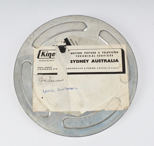
Film, Lord Dunrossil, 1960
Black and white film showing a Legacy Demonstration performing for Lord Dunrossil. Viscount Dunrossil was Governor General 1960-61. Demonstration for him and his wife by Legacy children at a primary school showing library, craft classes, exercise classes and woodworking. Both he and Lady Dunrossil interacted with the children, who appear overawed by their visitors and the fact that they were being filmed. There are also Legatees present. The girls wear a light coloured uniform with a Legacy logo embroidered onto the left hand side of the chest. The boys wear a shirt, tie and pullover. The lady who appears to be the headmistress is wearing a hat and gloves, whilst Lady Dunrossil wears hat, gloves and fur stole. 7 mins 17 secs. 16mm B&W no sound. His brief year in office as Governor General ended when he passed away suddenly 3 Feb 1961. According to an article in Trove, he toured Gippsland in August 1960 and attended a school and a festival, the proceeds of the festival was donated to Legacy and other charities. This film has been digitised to preserve its content. Melbourne Legacy gratefully acknowledges the support of the Victorian Government and Public Record Office Victoria for making this possible.Legacy had a high profile in the community at the time, which is indicated by the Governor General attending a school which was educating Legacy children.Silver metal canister with a reel of film about Lord Dunrossil.Handwritten label 'Lord Dunrossil'. Kodak Limited London, bottom of canister.junior legatee outing, governor general, junior legatee, patron -
 Kew Historical Society Inc
Container - Presentation Jewellery Box, 1948
In 1948, the citizens of Kew presented this jewellery box to the outgoing Mayor and Mayoress of Kew, Cr & Mrs W D Vaughan. In 2021, it returned to Kew, thanks to the generous donations of our Friends of the Collection. William David Vaughan to whom the jewel box was presented in 1948 was a publisher, politician and historian, born in 1897 at Heathcote. By 1922, he had become a publisher and Secretary of Victorian Newspapers Ltd. In October 1922, he married Muriel Gladys Frazer in Bendigo. He purchased 'Elsfield' in Cotham Road, renamed it 'Carramar', and resided there for almost fifty years. His wife, the Mayoress, was an accomplished pianist and entertained the wives of councillors and supported many charitable works from her home. In 1926, Vaughan founded a local newspaper, the Kew Advertiser. During his second term as Mayor, he was elected president of Melbourne Suburban Newspapers’ Association, In April 1947, he was appointed to and later became chairman of the Free Library Services Board. In 1960, he published his history of Kew - 'Kew's Civic Century'. Vaughan’s third term as Mayor in 1962-63 saw the erection of the pavilion at Victoria Park and the final clean-up of the Outer Circle Railway. He died in September 1976. This inlaid and engraved jewellery box was part of a larger donation made to the Mayor and Mayoress of Kew in 1948 by the citizens of the municipality. It is the only 'civic award' in the collection given to a former civic leader and complements the large collection of civic portraits in the collection. The box is additionally significant because of its association with William David Vaughan - newspaper proprietor, local politician, and local historian. A presentation jewellery box, she-oak with barber pole inlay adorned with an Australian silver plaque.Engraved inscription on silver plaque - "Presented to Cr & Mrs W.D. Vaughan With The Esteem And Appreciation Of The Citizens Of Kew And In Recognition Of their Services As Mayor And Mayoress 1947-48. 28th July 1948"w d vaughan, mayors of kew, kew advertiser, kew (vic.) -- history -
 Melbourne Legacy
Letter, Enez Domec-Carre, 01/01/1959
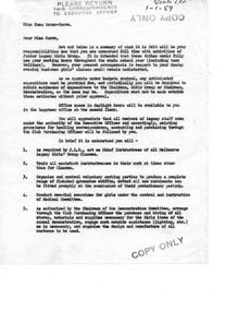
A letter of appointment to Miss Enez Domec-Carre outlining duties and remuneration for Chief Instructress of all Melbourne Legacy Girls' Group Classes. Enez was the supervisor of the girls classes held at Legacy House for many years. She organised many annual demonstrations and was held in high regard by Legacy. The library at Legacy House is named in her honour. See also a newspaper article at 00978 which outlines her achievements, a summary of her career at 00458 and 00129. She was a former Miss Victoria and was known for her physical education skills and for introducing grace and culture to Melbourne. In 1932 she joined Melbourne Legacy as assistant to Mrs Gilles (wife of a Legatee) later became the chief instructor of girls' physical education until she retired aged 65. In the post World War II baby boom the Legacy evening classes were attended by about 400 girls. She helped organise Legacy Widows and Legatee wives to sew the costumes for performances. Among her proudest moments was a display by 1000 Junior Legatees at the MCG during the 1954 visit of Queen Elizabeth II. As well her work for Legacy she ran physical education, ballroom dancing and debutante preparation classes.A record of the appointment and duties of Miss Enez Domec-Carre as Chief Instructress of Legacy Girls' ClassesWhite quarto paper carbon copy, a letter x 2 pages to Enez Domec-CarreHandwritten "Girls classes 1-1-59" Stamped "COPY ONLY" and "PLEASE RETURN THIS CORRESPONDENCE TO EXECUTIVE OFFICER"annual demonstration, girls' classes, enez domec carre -
 Melbourne Legacy
Document - Speech, Miss Enez Domec-Carre, 1970
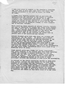
A narrative of Miss Enez Domec-Carre's work with Melbourne Legacy. Appears to be text of a speech made on her retirement which was on 31 December 1970. Enez was the supervisor of the girls classes held at Legacy House for 36 years. She organised many annual demonstrations and was held in high regard by Legacy. The library at Legacy House is named in her honour. See also a newspaper article at 00978 which outlines her achievements, a summary of her career at 00458 and 00129. She was a former Miss Victoria and was known for her physical education skills and for introducing grace and culture to Melbourne. In 1932 she joined Melbourne Legacy as assistant to Mrs Gilles (wife of a Legatee) later became the chief instructor of girls' physical education until she retired aged 65. In the post World War II baby boom the Legacy evening classes were attended by about 400 girls. She helped organise Legacy Widows and Legatee wives to sew the costumes for performances. Among her proudest moments was a display by 1000 Junior Legatees at the MCG during the 1954 visit of Queen Elizabeth II. As well her work for Legacy she ran physical education, ballroom dancing and debutante preparation classes.Description of the contribution to the work of Melbourne Legacy by Miss Carre with Girls' Classes and in other areas.Off-white photocopy of typed speech by W.V. Scott. 3 pages.Top right corner of page one "1970" handwritten in blue pen. "W.V. Scott" handwritten in blue pen following text on page three.girls' classes, annual demonstration, enez domec carre