Showing 25231 items matching " north"
-
 Ballarat Tramway Museum
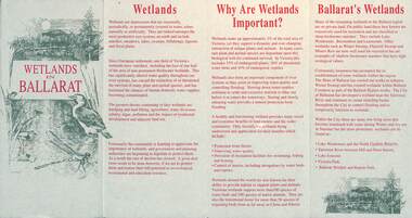
Pamphlet, City of Ballarat, "Wetlands in Ballarat", early 1990s
The pamphlet provides information about the wetland areas in the Ballarat district, in particular the ones in the North Gardens Reserve and Lake Wendouree. Provides information on the importance of the Wetlands, locations and a map. As well, provides contact details for the Department of Conservation and Natural Resources and the City of Ballaarat. Based on the spelling of the City of Ballaarat pamphlet early 1990s.Yields information about the Ballarat's wetlands within in which the tramway museum operates.Pamphlet - 4 fold DL printed in red and green ink.city of ballarat, wetlands, lake wendouree, conservation -
 Ballarat Tramway Museum
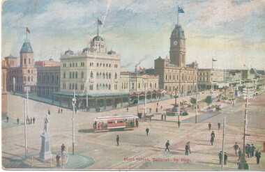
Postcard, "Sturt Sreet Ballarat - by Day", c1905
Postcard shows an Electric Supply Co. tram turning from Sturt St into Lydiard St North. Has Criag's Hotel, the National Mutual Assurance buildings and the Town Hall in the view, along with the Robbie Burns statue. On the rear is a letter - to Ruby from Harry and a Victorian 1d stamp, but no address. No indication of a publisher.Yields information about the Sturt and Lydiard St intersection, soon after the opening of the electric trams in Ballarat. Postcard, Divided back, coloured with a letter on the rear.See letter.ballarat, postcards, sturt st, lydiard st north, town hall, craigs hotel, esco -
 Kew Historical Society Inc
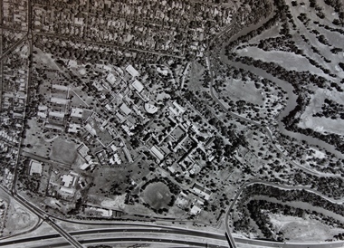
Photograph - Aerial Photograph, Aerial Photograph of Willsmere, circa 1980, c. 1980
This aerial photograph shows the Kew Cottages, and doctors/clergy residences on the north side of Wills Street, before the State Government sold the land for residential development. The doctors residences in Wills street were made of 'Glen Iris' Olympic Bricks. According to neighbours of the time most of the buildings were demolished overnight in the 1980s.Aerial photograph of Willsmere and the Kew Cottages bounded by the Boulevard, the Chandler Highway, Princess Street and Fellows Street. The roundabout at the intersection of Princess Street, Wills Street, and Eglinton Street is at the top left. The Eastern Freeway is at the lower edge of the photograph.kew cottages, eastern freeway, willsmere, yarra river, aerial photographs -- kew (vic), kew boulevard, willsmere mental hospital, kew mental hospital, kew childrens cottages -
 8th/13th Victorian Mounted Rifles Regimental Collection
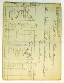
Legal record - Bank book, 1912 Circa
The 16th Light Horse Regiment was a Citizen Military Force unit located in North East Victoria with its Headquarters at Benalla. The regiment came into existence as part of a reorganisation of Australian Military Forces in 1912 replacing earlier Victorian Mounted Rifles units, and was in turn redesignated 8th Light Horse (Indi) Regiment in 1919.A rare bank book detailing how a CMF regiment conducted its financial affairs in the pre-World War 1 (1914-1918) period.Black clothboard covered bank book issued by the National Bank of Australasia Limited, Benalla Branch for the account of the 16th Light Horse Public Monies Account. The book was in use from December 1912 to March 1919.16th light horse, national bank of australasia, military, bank account, cmf -
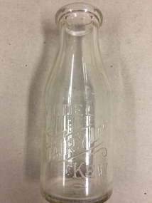 Kew Historical Society Inc
Container, Model Dairy, Milk Bottle, Twentieth Century
The Model Dairy was founded by the Kew pioneer, James Venn Morgan. The dairy had a number of different locations in Kew depending on the time period. Its final location was on the north side of Cotham Road, Kew between Ridgeway Avenue and Kent Street. Its final factory was designed by the architects Bates, Smart and McCutcheon.Kew was a major milk producing district in the Nineteenth and early Twentieth centuries, with three major dairy farms lining the Yarra between Studley Park in the west and Burke Road in the east. In addition to these dairy producers, there were also a number of accredited dairy retailers in the suburb. The largest and most enduring of these was the Model Dairy founded by the Kew pioneer James Venn Morgan. Milk bottles that include the name of the producer or retailer are historically significant as they represent a period in Kew's history before the mass production of milk in the second half of the Twentieth Century. A number of these named bottles have the additional attribute of rarity.Milk bottle - Model Dairy Kew. Pressed inscription: "Model Dairy Ltd Kew." Reverse: " This bottle contains milk bottled for sale by Model Dairey Ltd and always remains their property. It is loaned & cannot legally be used by others. One Imperial Pint. This bottle differs from 1981.0009 in that it does not have two pressed rings on the neck of the bottle.milk bottles, model dairy (kew) -
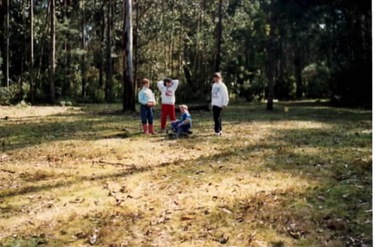 Sunbury Family History and Heritage Society Inc.
Photograph, Gundiwindi School camp, 14th - 18th August 1989
The photograph was taken in 1989 when students in Grades 4 and 5 from Bulla Primary School attended a school camp at Gundiwindi Camp. The camp is in the Yarra Valley area on the border of North Wandin and Silvan. At the camp the children were learning bush survival skills, which were practised by the local indigenous people.The emphasis on the camp at Gundiwindi was bush survival and skills used by indigenous people.A non-digital coloured photograph of four children in a bushland setting attempting to build a camp fire in the cleared area. the forested area is behind the group.school camps, gundiwindi, bulla primary school, indigenous culture -
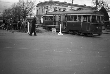
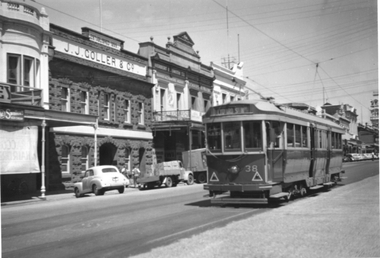 Ballarat Tramway Museum
Photograph - Tram 38 Lydiard St Nth, mid 1950s
The photograph shows SEC Ballarat tram No. 38 outbound in Lydiard St North, Ballarat. The tram has large reflective triangles on the front that were added during 1956. In the background is the bluestone building of J J Coller & Co and other buildings on the east side of the street. Photographer and date unknown - mid-1950s.Yields information about tram 38 and Lydiard St North Ballarat.Black and White print on plain paper.tramcars, tram 38, lydiard st nth -
 Melbourne Tram Museum
Slide - Tram 449 William St, Keith Caldwell, 14/03/1966
Photo by Keith Caldwell of W2 449 north bound in William St, about to cross Little Lonsdale St, running a route 55 West Coburg. Tram has a advert for Remy Martin Brandy. Alongside the tram is the Metropolitan Hotel. William St has the centre poles in the view - 14/3/1966Yields information about William St Melbourne and tram services.Perutz colour slide, grey plastic mount,In ink "Bourke 14.3.66" and a purple date stamp.trams, tramways, william st, w2 class, route 55, west coburg, tram 449 -
 Melbourne Tram Museum
Photograph - Track laying Nicholson St and Holden St, 1956
Photograph shows construction of new track including a turnout to the right. While no notes are attached, landmarks indicate the photograph is of Nicholson St, North Fitzroy looking northward over Holden St/Brunswick Rd with a track connection to the remaining single track in those streets. This line was constructed in 1956 to replace the bus service.Yields information about construction of Bourke st electric line Black and white photograph with blue biro measurements on rearHandwritten notes read: '16, 8 2/16 x 6 1/8'm&mtb, track laying, nicholson st, east brunswick, holden st -
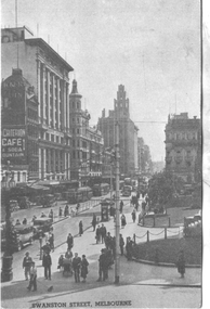 Melbourne Tram Museum
Postcard, "Swanston Street, Melbourne", 1930s
Southern Series No. 30, titled "Swanston Street, Melbourne" looking from the roof of Princes Bridge railway station, north along Swanston Street. Has at least four trams in the view, along with the long Safety Zone Stop handrails for the southbound tram stop. In the background is a sign for the Criterion Cafe & Soda Fountain.Yields information about Swanston Street during the 1930s.Postcard - printed, unused, Southern Series No. 30trams, tramways, swanston st -
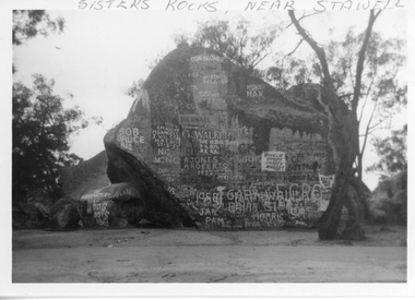 Stawell Historical Society Inc
Photograph, Sister Rocks 1962
Sisters Rocks 1962 By Marion Mitchell-Robinson. The photo shows the graffiti on the north side of the rock. There is a dead tree to the right of the photo. This photo is of a well known land mark along the Western Highway. They take their name from 3 sisters named Levy, who camped there with their parents during the early days of Stawell.Black & White photo of Sister Rocks. "Sister's Rocks, Near Stawell" written on the front in biro. Inscribed on the back "Sisters Rocks Stawell Vic. May-June 1962 Taken c1962 by Marion Mitchell-Robinson".tourism -
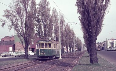 Melbourne Tram Museum
Album - Robert Thomson Slide Collection, "Melbourne 1965 April Box 2"
Photo - see pdf file for further information. Number Brief Description RT137 Peel St - tram 392 - "West Coburg via William St" - route 55 RT138 Batman Avenue - tram 954 - "Prahran" - route 77 RT139 Batman Avenue - tram 388 - "Wattle Park Elgar Rd" - route 70 RT140 Elizabeth Street - tram 949 - "North Coburg" - route 19 RT141 East Coburg Ter - tram 668 - "South Melb Beach" - route 1 RT142 Royal Pde Jct - tram 764 - "North Coburg" - route 19, Haymarket, Hotel Gresham RT143 High st - tram 979 - "City Spencer St" - route 90, Clifton Hill RT144 High St - tram 1036 - "East Preston" - route 88, Clifton Hill RT145 tram 52 - "Footscray" - route 82, Maribyrnong River bridge reconstruction RT146 tram 802 - "City via North Melb" - route 57, tram 599, West Maribyrnong - Maribyrnong River bridge reconstruction RT147 tram 52 - "Footscray" - route 82 Raleigh Road, near Rosamond Road RT148 tram 52 - "Footscray" - route 82 at Moonee Ponds, Ascot Vale Road Demonstrates the work of Robert Thomson in photography, collection and/or production of slidesAssembled album in a black presentation folder of 12 colour slides, collected or produced by Robert Thomson. All photographs have been scanned and placed on the Museum's G drive. A list of all photographs with details has been compiled. melbourne, tramways, trams -
 Bendigo Historical Society Inc.
Document - Hustlers, Sheepshead and Deborah lines of reef
Albert Richardson was a mining historian who wrote widely on the mines of the Bendigo Goldfield. The park opposite the Goldmines Hotel in Marong Road, is named in his honour. Five page document, hand written by Albert Richardson on lined foolscap and edited with cross-outs and insertions, . The mines along the Hustlers line of reef and the Sheepshead line of reef are described. Mines listed on Hustlers line of reef: Fortuna Hustlers (1888 - 1913), shaft 2,240 feet at rear of Buckell and Jeffrey's offices; Royal Hustlers Reserve No. 2 - two shafts 'City" 860 feet, now covered by R.S.L. building Pall Mall, steel poppet legs 60 ft high and 'Park Shaft" at rear of Camp Hill School, 1,775 feet, steel poppet legs 60 feet high; Hustlers Hill Group first worked by Jonathan Harris in 1853 and bounded by Valentine, Anderson and Ironbark Creek to the north and Milroy Street to the east, one of first areas worked for quartz reefing. It with Garden Gully line west and Victoria Hill Ironbark, formed by far the richest cross section of the Bendigo Goldfield. Great Extended Hustlers (1865-1921) close to intersection of Anderson Street and Hustlers Road, mullock heap against road and shored up around shaft, steel poppet legs now at Wattle Gully mine, Chewton, large winding machine, air compressor south of shaft and 36 head crushing battery. Hustlers Reef (Old Hustlers) and Hustlers Reef No. 1, two shafts, main 2,210 feet, about 220 yards east of Moran Street and against Fenton Street. , No. 1 shaft 1,140 feet and about 155 yards east of Moran Street. Lansell's Comet, Lightining Hill line, 2.100 feet, on Comet Hill approx 70 yards west of Holmes Road, near Comet Creek, steel poppet legs. United Hustlers and Redan (1876-1918), main Redan, 1,830 feet about 155 yards west of Sandhurst Roead, in line with Comet Hill State School, this hill known as Redan Hill. North, or New Hustlers, once known as Agnew Hustlers, wooden poppet legs, south side, Kneebone Street, Eaglehawk. Derby line, Johnson's No. 3, South Johnson's (east shaft of Collman and Tacchi) 439 feet on west wide of Woods Street, south of Wetherall Street. Paddy's Gully Line, south to north, some shafts - Lansell's 'Sandhurst" ('Needle") Eaglehawk Road shaft 2,425 feet, about 50 yards east of Needle Loops, a brick square sided chimney with Cleopatra Needle top. British American, 789 feet, just south of Holdsworth Road. Collman and Tacchi, main shaft 2,588 feet, 60 yards west of Eaglehawk Road, California Gully. Deborah Line of Reef, The Deborah (1932-1954) shaft 2.017 feet, west of Adams Road and south of Abel Street, Quarry Hill. North Deborah (1937 - 1954) shaft 1,151 feet, Breen Street, Quarry Hill, steel poppet legs. Central Deborah (1939-1954) shaft 1,347 feet Sheepshead line of reef, Lansell's South Red, White and Blue, shaft 2,124 feet, north east of Bellevue Road and 220 yards east of Adams Road. The New Red, White and Blue Consolidated (Big Blue) main shaft 2,416 feet. Lansell's Bendigo Battery 105 head, north of 'Big Blue" on his freehold lease, commenced crushing on 24th February 1895. After closing was erected as the Showground's Industrial Hall, July 1926. North Red, White and Blue, burnt down February 1926, new company 1934, closed 1938. Document is part of the Albert Richardson Collection of Bendigo mining history. bendigo, gold mining, deborah line of reef, sheepshead line of reef, hustlers line of reef, royal hustlers reserve mine, hustlers hill group of mines, great extended hustlers, hustlers reef no. 1, lightning hill line, old comet, collman and tacchi, lansell's comet, north deborah, central deborah, dhrrpdhrsf linr og trrg, new red, white and blue consolidated mine, big blue, lansell's bendigo battery, north red, white and blue mine, albert richardson collection -
 Ballarat Tramway Museum
Ephemera - Tour Notes, Victorian Railways and Australian Railway Historical Society, ARHS Tour to Ballarat, titled "The Ballarat Bonanza", Feb. 1967
Set of four foolscap size sheets, for ARHS Tour to Ballarat, titled "The Ballarat Bonanza" on 25/2/1967, stapled in the top left hand corner. Included trips on the Eureka and Redan lines. 1. - Welcome Aboard circular - printed on green paper - giving trip information - Yarra Car, Safety, timetable notes, photostops, refreshments, sales and tours of either the workshops or a tram tour. Trip via North Geelong to Ballarat, return via Bacchus Marsh. Booking Officer R. Carlisle, Tour Organiser E. (Ted) Davies. 2. Descriptive notes - printed on yellow paper, including notes on the various lines, speed limits, the train, the tramways and North Ballarat Workshops. Notes provided by Keith Kings. 3. Two page Special train notice or S Circular, S440/67, dated 17/2/1967, giving timetables, crosses, loads, motive power. Signed by T.A. James as Chief Traffic Manager. Images of document added 27-08-12.arhs, ballarat, eureka, redan, special trains -
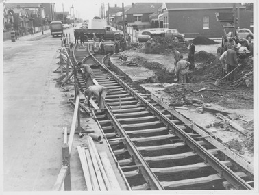
 Ballarat Tramway Museum
Negative, Wal Jack, Jun. 1951
Yields information about the reconstruction of track at Hospital Corner and the way tram services were arranged and the corner itself.Negative and Digital image of the Wal Jack Ballarat Negative file of No. 35 crossing Sturt St while trackwork is being undertaken to replace diamond crossing at Hospital corner. The tram has the destination of Lydiard St North and is proceeding to Drummond St North to reverse. Based on Reg Item 5623, the work was done June 1951. In the background is H. E. Herbert's grocery shop, advertising "Rowland's" - soft drinks - see https://bih.federation.edu.au/index.php/Rowlands_Soft_Drink_Factory Reg Item 5079 - drawing of 6/1950 showing details of the crossing to be replaced. Reg Item 5340 - shows the building as well. Reg Item 5623 - has a note about the trackwork being undertaken on 19/6/1951. Reg Item 6225 - shows the new building being built during 1962. Reg Item 7720 - photocopy from Reg Item 5623 Reg Item 7721 - photocopy of the relevant page from the August 1951 issue of Electric Traction which details the event. trams, tramways, hospital corner, drummond st, sturt st, trackwork, tram 35 -
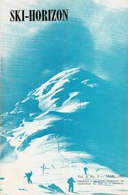 Falls Creek Historical Society
Journal - Ski-Horizon Vol 4 No 7
Ski-Horizon is the official journal of the Federation of Victorian Ski Clubs which began publication in 1949. The were 26 original member clubs which included Albury Ski Club, Bogong Ski Club, Myrtleford Ski Club, Tallangatta and District Ski Club and Wangaratta Ski Club. Two pioneers of Falls Creek, Tom Mitchell, M.L.A., and Martin Romuld were Vice-Presidents of the Federation.This Journal is significant because it documents the early development of skiing in Victoria.The journal features stories and events chronicling developments in Victoria and internationally. Items related to the Falls Creek Area in this issue include:- Page 2:- Tonl St. Elmo (Nissen Alpine Club) had been appointed as a Justice of the Peace. Climatologists with the CSIRO reported that the mean daily temperature of summer in Victoria and NSW had fallen by 3°F since 1880 whilst in the Northern Hemisphere summers were becoming warmer. Page 5: There was to be no Queen's Birthday holiday this year but Tuesday 2nd June would be a public holiday for Coronation Day. Page 11: Featured "They're Busy in the North-East" - nothing has been heard of the Sydney Clubs which had proposed building at Falls Creek and Beechworth seems to be in danger of losing its site. Nissen Alpine Club has had plans for extension approved. A new rope was being installed for the Nissen tow. Falls Creek was undoubtedly the most progressive centre in the North East. For a slightly rougher experience Cleve Cole Memorial Lodge was recommended.tom mitchell m.l.a., toonallook, fred griffith -
 Bendigo Historical Society Inc.
Administrative record - North Bendigo Gold Mining Company N.L, 1911 - 1920
Green hard cover minute book, buff binding on spine with 'Minute Book' on spine on red background. Three hundred and sixty three pages of entries. . Dates of minutes from 8th February 1911 to 25th October 1920. Three documents inserted in back page of Minute Book: 'Gold Producers Association,, 48 Queen Street, Melbourne 10th January 1921 (circular to shareholders) 'North Bendigo Gold Mining Company No Liability' stamped in purple ink on top of page; The Chamber of Mines of Victoria, Australia, Inc. to the Manager, North Bendigo Co., N.L., levy made on 25/11/20 of 1 pound per 1000 pounds paid in wages; affixed to inside back cover 'Bendigo Mine Owners' and Managers' Association, City Chambers, Bendigo, December 8th 1912., detailing 'resolutions which were carried unanimously', signed G.A. Petrie. Minute book forms part of the Margaret Roberts Collection of mining records. bendigo, mccoll and rankin, margaret roberts, north bendigo gold mine n.l. -
 Bendigo Historical Society Inc.
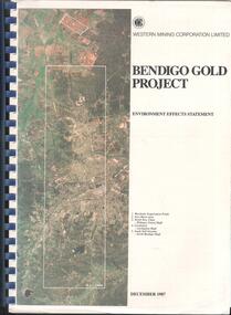
Booklet - Kangaroo Flat Gold Mine Collection: Western Mining Corporation Bendigo Gold Project Environmental Effects Statement December 1987, Western Mining Corporation, Bendigo Office, Western Mining Corporation Limited Bendigo Gold Project Environment Effect Statement December 1987, December 1987
Spiral bound booklet, plastic cover, black plastic binding, On front cover: Western Mining Corporation Bendigo Gold Project, Environment Effects Statement, December 1987. On front page, colour aerial photograph of Bendigo mining areas mentioned in report. Key on front page related to photograph: 1. Woodvale Evaporation Ponds. 2. New Moon area. 3. North New Chum Williams United shaft. 4. Carshalton, Carshalton shaft. 5. South Nell Gwynne, North Bendigo shaft. Contents: historical perspective; Western Mining Corporation Ltd Bendigo activities; project outline, project approvals - controlling factors, elements of the mining project, surface based exploration, underground operations and surface support, mining areas and operations ore and mullock haulage, New Moon area, water management, environmental management. Planning and land use, socio-economic environment, physical environment and biological environment are examined and discussed. bendigo, goldmining, bendigo mining nl, bendigo goldfield, environmental effects statement, bendigo gold project, woodvale evaporation ponds, new moon, north new chum, carshalton, south nell gwynne, western mining corporation -
 Melbourne Tram Museum
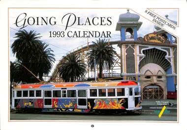
Ephemera - Calendar, Public Transport Corporation (PTC), "Going Places - 1993 Calendar", 1993
Calendar - 16 pages - card cover, full colour, titled "Going Places - 1993 Calendar", published by the Public Transport Corporation featuring public transport photos and 8 postcards in the centre - perforated. Tramway items imaged along with a note about the photograph itself. image 1 - cover 2 and 3 - February - St Kilda Rd From the BP Building, looking north at Dawn 4 and 5 - April - B2 2038 outside the Princess theatre in Spring / Nicholson St 6 and 7 - June - Y 469 as "The Melbourne Tram" with Flinders St in the background. 8 - Postcards - W1 421 decorated for the Royal visit of , Flinders St station with cable and electric trams, Spirit of Progress on Test and the line up of Double deck buses at North Fitzroy. 9 and 10 - August - B2042 in the Bourke St Mall 11 and 12 - October - W5 816 as the Leunig Tram with Luna Park behind. 13 and 14 - December - W2 442 as the Restaurant tram with the Arts Centre behindtrams, tramways, ptc, y class, tourist trams, b class, restaurant tram, st kilda road, transporting art, flinders st station, double deck buses, bourke st, spring st, tram 462, tram 816, tram 2042, tram 442, tram 421, tram 2038 -
 Bendigo Historical Society Inc.
Document - VICTORIA HILL - THE RICH VICTORIA HILL AND ITS HISTORICAL ASSOCIATIONS
Copy and a photocopy of notes titled 'The rich Victoria Hill and its Historical Associations. The photocopy does not have copies of the photos. Notes include Introduction, directions for getting to Victoria Hill, North Old Chum Mine 2310 ft deep, Ballerstedt's First Open Cut, Geographical Features, Lansell's Big 180, Crushing Battery, Lansell's Cleopatra Needle type chimney, Victoria Quartz Mine 4613 ft deep, Victoria Reef Quartz Company, Victoria Quartz Company, Victoria Quartz Dams, Rae's Open Cut, Quartz Roasting, Floyd's small 5 Head Crushing Battery, Great Central Victoria (Midway) Shaft, Ballerstedt's Small 24 yard Claim, The Humboldt, The Adventure, The Advance and Luffsman and Sterry's Claim. Copies of photos include: Victoria Hill from Rae's Open Cut, Looking North from Old Chum Hill to the Victoria Hill, the Victoria Quartz Mine and Wm. Rae's Crushing Works.document, gold, victoria hill, the rich victoria hill and its historical associations, j n macartney, quartz miners' arms hotel, ironbark methodist church, john brown knitwear factory, little 180, george lansell, conrad heinz, british and american hotel, victoria reef gold mining company, manchester arms hotel, housing commission homes, the ironbark, hercules and energetic, midway, wittscheibe, great central victoria, wm rae, mr & mrs conroy, moorhead's shop, central nell gwynne, gold mines hotel, david chaplin sterry, new chum & victoria, old chum, burrowes & sterry, rotary club of bendigo south, big 180, north old chum mine, ballerstedt's first open-cut, lansell's bit 180 shaft, victoria quartz mine, victoria reef quartz company, a roberts & sons, mr e j dunn, h harkness & sons, new chum drainage scheme, eureka extended, new chum railway, the pearl, inrush of water, shamrock, shenandoah, victoria quartz dams, rae's open cut, floyd's small 5 head crushing battery, great central victoria (midway) shaft, midway no 2, midway north, the humboldt, the adventure, the advance, luffsman & sterry's claim, chinese joss house, fortuna, p m g repeater station, bendigo and vicinity 1895, j n macartney 1st edition 1871, mr rae anderson, 'gill family, annals of bendigo obituary notices 1904, mining records and australian mining standard special edition 1/6/1899, bendigo advertiser 22/6/1871, b m l records mines department, patterson's goldfields of victoria, dickers mining record 23/11/1861, annals of bendigo, bendigo advertiser 24/7/1933, 27/8/1908, 30/6/1910, 16/6/1910, 17/6/1910, mining reports for 1910, australian mining standard special edition 1/6/1899 p40, bendigo mines ltd, mines department records, the bendigo goldfield 1851 to 1954, the victoria hill 1854 to 1949, wm rae's crushing works -
 Warrnambool and District Historical Society Inc.
Ephemera - Badge, Warrnambool High School, c 1980
This is a Warrnambool High School badge . Warrnambool High School was established in 1907 and was housed in various locations around Warrnambool until 1961 when it moved into a purpose built building in Albert Park, Warrnambool . It merged with Warrnambool North Technical School to become Warrnambool College.in 1994..The badge is of superior quality and was probably given to visitors.This is retained as a memento of Warrnambool High School which was established over 100 years ago. A circular metal badge with gilt edging and the school emblem in black and gold on a green background.There is a stud clip at the back.and a a fob chain attached. WHS Nil Sine Labore Taiwan warrnambool high school, warrnambool, badge -
 Eltham District Historical Society Inc
Document - Folder, Murphy, James and descendants
James Murphy was a mining surveyor involved with the Caledonia diggings. Contents Note from Ray Blake, 26 April 2000: Ms Murphy said her people had traditionally owned all of inner Melbourne, north to the Great Divide, West to Werribee River, East to Mt Baw Baw, South to Mordialloc Creek.Newspaper clippings, A4 photocopies, etcjames murphy -
 Eltham District Historical Society Inc
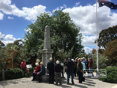
Photograph, Peter Pidgeon, Eltham War Memorial, 903-907 Main Road, Eltham, 4 November 2017, 4 Nov 2017
Eltham District Historical Society heritage walk to follow the boundaries of the original Shillinglaw Farm in central Eltham, held Saturday, 4th November, 2017. The Shillinglaw Farm comprised Lot 90 of Holloway’s 1851 Little Eltham subdivision. It was originally 30 acres in area and situated east of the Diamond Creek and north of Henry Street.Born digital imageeltham war memorial, obelisk, war memorial buidings, war memorial hall -
 Eltham District Historical Society Inc
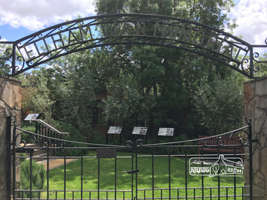
Photograph, Peter Pidgeon, Eltham War Memorial, 903-907 Main Road, Eltham, 4 November 2017, 4 Nov 2017
Eltham District Historical Society heritage walk to follow the boundaries of the original Shillinglaw Farm in central Eltham, held Saturday, 4th November, 2017. The Shillinglaw Farm comprised Lot 90 of Holloway’s 1851 Little Eltham subdivision. It was originally 30 acres in area and situated east of the Diamond Creek and north of Henry Street.Born digital imagecr. e.j. andrew, eltham war memorial, ernie andrew, war memorial buidings, war memorial garden, war memorial gates -
 Eltham District Historical Society Inc
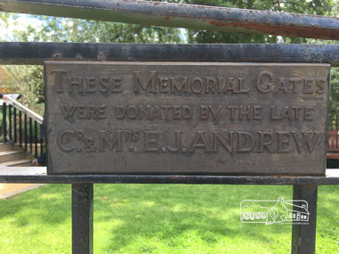
Photograph, Peter Pidgeon, Eltham War Memorial, 903-907 Main Road, Eltham, 4 November 2017, 4 Nov 2017
Eltham District Historical Society heritage walk to follow the boundaries of the original Shillinglaw Farm in central Eltham, held Saturday, 4th November, 2017. The Shillinglaw Farm comprised Lot 90 of Holloway’s 1851 Little Eltham subdivision. It was originally 30 acres in area and situated east of the Diamond Creek and north of Henry Street.Born digital imagecr. e.j. andrew, eltham war memorial, ernie andrew, war memorial buidings, war memorial garden, war memorial gates -
 Bendigo Military Museum
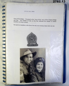
Document - DOCUMENTS WW2, post 1955
Photos relate to CAPTAIN R EMOND's WWII service in the Middle East & North Africa. 2782.7 - 2782.9 relate to Queen Elizabeth's visit to Bendigo in March 1954. 2782.11 & 2782.12 depict soldiers marching through Charing Cross, Bendigo. 2782.13 shows CAPTAIN EMOND & Gov Dallas Brooks inspecting the 38th Battalion.Collection of black & white photos & documents related to CAPTAIN RUSS EMOND. Copied photos & captions have been glued to A4 pages. x 13 pages in blue plastic display folder..13) "14 Mar 55. The Gov of Vic Sir Dallas Brookes inspecting guard of honour from 38 Inf Bn. Guard Commander - Capt Russ Emond"documents - copies, photography-photographs-copies, military history, passchendaele barracks trust -
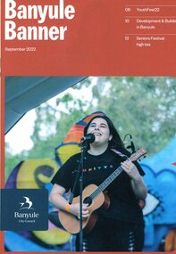 Greensborough Historical Society
Magazine, Banyule Banner September 2022, 2022_09
The Banyule Banner is published bi-monthly by Banyule City Council to advertise upcoming events in the City of Banyule and to report on past events. This edition contains reports on YouthFet22, Development and building in Banyule and an invitation to Seniors Festival high tea. The wrap around calls for community consultation on the North East Link and its impact on Watsonia.A record of events within the City of Banyule.24 pages, colour illustrations. 2 copies. This edition has wrap around sheet.banyule banner, banyule council, north east link -
 Greensborough Historical Society
Map, Heidelberg. Historic River Landscape Assessment. Historical maps: Map C 1851-1863. "The Garden of the colony", 1985c
Geographical area of around 35 sq. kilometres marked with physical features such as major roads, vegetation and properties, with locations and notes of the increasing number of farms, gardens orchards and vineyards which had become established in addition to pastoral runs. Bounded by Shire of Diamond Valley to the North, Darebin Creek to the West and Plenty River to the East.Black and white sketch map on white paperheidelberg, heidelberg - maps -
 Greensborough Historical Society
Map, Melbourne and Metropolitan Board of Works. Survey Division, MMBW, Yarra 2500 / 14.27. Yarrambat, Yan Yean Road, 1978_04
Melbourne and Metropolitan Board of Works. Yarra 2500 [base map] 14.26. Yarrambat, Yan Yean Road. Parishes of Morang 3183 and Greensborough 2724. Municipality of Diamond Valley 257. Prominent streets include: Yan Yean Road, North Oatlands Road and Pioneer Road. Features include Yarrambat War Memorial Reserve.MMBW Map in 1:2500 [scale] series. Cream parchment with green tape reinforcing on edges and punched holes on left edge.mmbw, melbourne and metropolitan board of works, shire of diamond valley, whttlesea, yarrambat - maps -
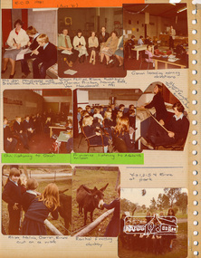 Eltham District Historical Society Inc
Photo Album page, Eltham Christian School, Nyora Road, Eltham, 1981-1984, 1981
Eltham Christian School, 1981, when the school first operated out of the Eltham North Soccer clubrooms. Page from magnetic photo album relating to the staff, students and activities of the Eltham Christian School which operated as part of the Eltham Christian Church at Nyora Road, Eltham. See also entries for each photograph.page from photo album with photos and captionseltham christian school