Showing 1886 items
matching north rd
-
 Kiewa Valley Historical Society
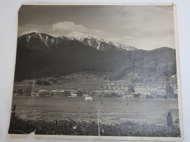
Photo - Mt Beauty c1948, Early photo of Mt Beauty Townhip c1948
Mt Beauty was constructed by the State Electricity Commission of Victoria to house employees of the Kiewa Hydro Electric Scheme. Mt Beauty township looking south east from Hollond's property c1948. Only one transmission line has been built.In the foreground are houses in Simmond's Creek Road. Some houses in North Beauty. The town is still under construction - not all roads have been made and houses haven't any garden around them.This is an early photo of Mt Beauty during construction of the town.d It shows a few houses in Simmonds Creek Road. Large black and white photo of Mt Beauty township with snow on the mountains in the background.mt beauty township 1948, mt beauty construction, simmonds creek road -
 Kiewa Valley Historical Society
Photos, Postcards - Kiewa Valley
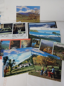
Mt Beauty township, at the head of the Kiewa Valley, is situated at the foot of Mt Bogong. The town was established by the State Electricity Commission of Victoria during the construction of the Kiewa Hydro Electric Scheme on the High Plains.Mt Beauty is a popular tourist resort. The main highway from Mt Beauty to the Bogong High Plains is most picturesque throughout the year. During the winter months, Falls Creek provides access to Falls Creek Ski Village for snow sports. Tawonga, 6.5 km north of Mt Beauty, is famed for its trout fishing and camping on the Kiewa River. Deciduous trees make a show of colour during Autumn. The postcards are of historical value showing photos taken at an earlier time.The postcards can be compared to the attractions of the time as they do not include cycling (mountain bikes and road bikes), snow boarding, gliding and paragliding. Advertising for tourism has also changed as attractions are now available on-line. 1. 9 Coloured Photos of Bogong (5) and Visitors Information Centre display (4) 2. Two fold out coloured sets of postcards "Mt Beauty and the Kiewa Scheme", "Mt. Beauty Victoria" 3. x10 Coloured postcards Mt Beauty, Kiewa Valley, Bogong 4. x6 Coloured postcards High Country and Bogong Villagepostcards kiewa valley -
 Kiewa Valley Historical Society
Brochure - Tawonga Caravan Park, Tawonga - Mt Beauty
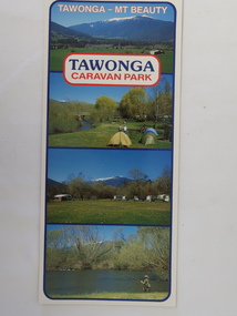
Tawonga Caravan park is on the Kiewa River situated north of Mt Beauty and 30 km from Falls Creek. Tawonga Caravan park has always been popular for families and fishermen with plenty to do.Colored cardboard brochure with 3 small photos on the front and information printed on the back with a small map.tawonga caravan park, trout fishing -
 Kiewa Valley Historical Society
Milkshake Containers
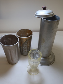
Milk Bars made flavoured milk shakes for customers. The drink included milk, flavouring and ice-cream.Mt Beauty had a cafe at the Mt Beauty shopping centre and there was a general store at Mt Beauty North.This milkshake set includes 2 metal mugs and 1 glass, mug size and 1 straw dispenser with lift up lid.milk shakes, milk bar, drink, cafe -
 Kiewa Valley Historical Society
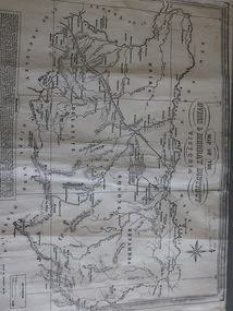
Map of the Ovens and Murray District of Victoria
The map features Beechworth and its history.This map features the north-east and in particular, Beechworth where residents of the Kiewa Valley may have shopped or visited for appointments.Black and white map with references to roads and gold. The centre of the map is Beechworth and in the bottom left side of the map is the heading Beechworth with 12 lines of print of information regarding Beechworth. The Kiewa Valley is not identified.beechworth -
 Kiewa Valley Historical Society
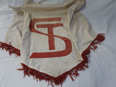
Banner - Tawonga School
Banners were often used for school functions eg. Sports Days to mark an area for children to gather/ meet. Or to identify a group during an event eg. a parade. The Tawonga School was opened in 1880. See KVHS 04882Tawonga School is in the Kiewa Valley. It is small rural school serving the farming and tourist town of Tawonga in Victoria's north east.Large white banner with ST (overlapping) in red and a red fringe on the bottom edged forming a V. The back is red. There is nothing to assist it being hung up.tawonga school banner, education, school sports -
 Kiewa Valley Historical Society
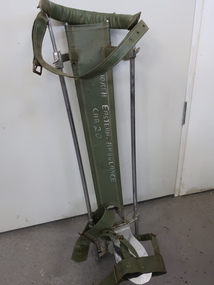
Splint
The ambulance officers would use this splint to restrict further movement of a leg. It supports and protects a broken bone or injured tissue and reduces pain and promotes healing by keeping the injured part of the body still. Splints are now designed for specific parts of the body and leg. New materials are available eg. plastic moulds and velcro to fasten straps.Used by ambulance officers in the Kiewa ValleyThe splint is made with 4 shiny upright rods. At the bottom it has 1 moveable stand at the back and 1 solid steel foot rest at the front. These have hinges to enable up and down movement.there is green vinyl around the curve at the top and as support for the back of the leg. There are 3 green leather straps attached - on the top, middle and the foot."North Eastern Ambulance / Car 20" in white on green vinyl.leg splint, ambulance equipment, first aid -
 Kiewa Valley Historical Society
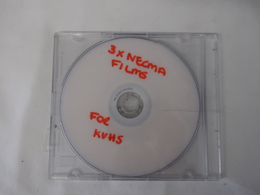
DVD - NECMA Films, Cultural Burning, Stone Implements, Weaving, Plants
The North East Catchment Management Authority presents Indigenous knowledge and practices on film by way of a DVD allowing it to be played on a screen such as a computer or linked to a TV screen.Indigenous knowledge and practices presented by film on a DVDDVD with title in red texta on silver side of DVD. Stored in hard, clear plastic containerRed Texta printed -' 3 x NECMA / Films / for / KVHSindigenous australians, north east catchment management authority, dvd film -
 Kiewa Valley Historical Society
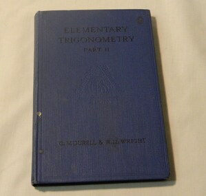
Book - Reference Maths, Elementary Trigonometry Part 11, Early to mid 20th Century
Elementry Trigonometry, a very good source of teaching trigonmetry for those who love maths according to book collectors! Would have been for form 2, or year 8. This item was donated by Wilma Davies who was a local identity in the Kiewa Valley in the North East of Victoria.This has historic significance as it shows what maths was taught in the early - mid 20th century. This book would have been used in the Kiewa Valley schools by a local identity Wilma Davies therefore has social significance and good interpretive capacity. This book is now out of print and is a collectible item. Blue covered maths book. Black writing for title and authorbook, school, text book, educational, wilma davies, maths -
 Kiewa Valley Historical Society
Mantle for Gas Lantern
Originally these mantles where produced to be used in gas street lights in Europe and North America cities.There use started in 1891. These mantles were used before electrical power street lighting was installed. They have been used ever since until safety concerns regarding radiation from their thorium infused particles made alternate mobile lamps more attractive. The age of open flame recreational lighting is fast coming to a close. The greater use of battery and generator powered lighting(ease of operation) has brought the costing of these alternative lighting to an acceptable level. The age of miniaturisation and volatility of the open flame has seen a greater swing to smaller and more stable lighting. These incandescent gas mantles were initially used in the Coleman White Gas LanternsThe Kiewa Valley, with its closeness to the Victorian Alps, allows greater opportunity for the "happy" campers to enjoy the outdoors. The lighting provided by the incandescent gas lamps allow the adventurer at heart to enjoy an alternative lifestyle and still having the comforts of "home" at their finger tips. The numerous camping facilities in the Kiewa Valley and the upper alpine region is testament that those living in the cities need a break from the day to day grind and go to a quieter and more spiritual environment. Artificial lighting, as provided by mobile apparatus, is highly valued by the urban gypsy. The outdoor recreational industry has significantly provided for, if only at holiday time, an industry that has a relatively high employment rate and beneficial to local communities.The gas mantle is in a fabric, pear shaped, of rayon fabric impregnated with cerium. It's appearance is similar to a very small fishing net. The fabric is very ply-able until it is heated by an open flame then it becomes more rigid and lets out an incandescent white light. Its colour is white to off white. It has a draw string fastened a t the bottom (to wrap around the flame source)lighting, gas, heating, camping, outdoor equipment lamp -
 Eltham District Historical Society Inc
Book, Queenstown / St Andrews: A history of the district and the school by Nancy Mortimer, 1983
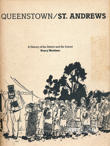
Local history book published on the occasion of the 125th anniversary of St Andrews Primary School 1983. Contents: Forward, Headmaster's message, early days at St. Andrews, School No 128: St Andrews, Why should children practice temperance, 3594 Queenstown North, 933 Smith's Gully, 1737 Smith's Gully, The Church of St Andrews, Post Office, St Andrew's Hotel. Includes some photos and illustrations including reproduced original documents. Includes list of head teachers 1858-1983. Includes names of pupils 1983.This book is significant in that not only does it traces the development of St Andrews Primary School and of education in the area but it also gives an insight into the people and their community.Softcover, 109 pagesqueenstown, st andrews, education, st andrews primary school -
 Eltham District Historical Society Inc
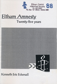
Book, Eltham amnesty : twenty-five years / Kenneth Eric Eckersall, 2002
The Eltham Branch (North East Metro Group) of Amnesty International was formed in 1977. This booklet documents its first 25 years.Paperback; iv, 27 p. ; 21 cm.amnesty international (eltham group), political prisoners -
 Eltham District Historical Society Inc
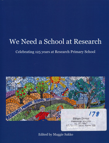
Book, Research Primary School, We Need a School at Research - celebrating 125 years at Research Primary School, edited by Maggie Sakko, 2014
History of Research Primary School, north-eastern suburb of Melbourne. Begins with condensed version of the 1989 history of first 100 years, then covers 25 years 1989-2014: buildings and facilities, principals, teachers, students, uniform, School Council, Parents Group, out of school care, curriculum, and special events such as productions and camps. Registers of principals, staff and students are included. Numerous photographs are included.100 pages : illustrations, portraits ; 28 cm.ISBN 9780646925172research (vic.) -
 Eltham District Historical Society Inc
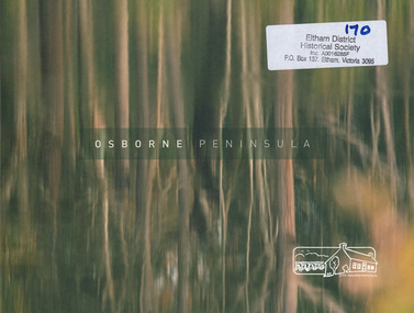
Book, North Warrandyte Landcare Group, Osborne Peninsula prepared by North Warrandyte (Osborne Peninsula) Landcare Group Inc, 2009
History of North Warrandyte Osborne Peninsula39 p. : ill., map ; 20 x 27 cm.[pasted inside front cover is a typed letter promoting the book addressed to "Dear Resident", dated 2nd August 2009] north warrandyte history, yarra river, osborne peninsula warrandyte -
 Eltham District Historical Society Inc
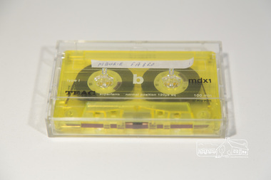
Audio Compact Cassette Tape, Maurie Fabbro, Audio Recording; Maurie Fabbro with Doug Orford, c.2000
Oral history Interview with Maurie Fabbro conducted by Doug Orford with Mary Reagan at Maurie Fabro's home in Kirby Street, North Eltham, Victoria The interview covers Maurie's life in Eltham. Maurie took over his parents farm which was located opposite Eltham High School and between the Diamond Creek. The house was located in Faulkiner Street. When the land was subdivided, Maurie moved up the hill to the site of the interview. Topics of discussion include: Maurie's Harley Davidson Motorcycle (mention of Keith Gibson), lack of electricity in Faulkiner Street, extreme weather of the past.Audio Cassette tape TEAC mdxi 100 min (yellow) Converted to MP3 file; 79.9MB, 1:03:08oral history, fabbro family, fabbro farm, faulkiner street, eltham, weather, motorcycles, doug orford, maurie fabbro -
 Eltham District Historical Society Inc
Photograph, North Riding Living & Learning Centre
One of a set of display images thought to be produced by the Shire of Eltham c.1979-1987. The North Riding Living and Learning Centre was located in Panton Hill.Illustrative of services provided by former Shire of ElthamColour photograph 20 x 29 cm mounted on green-painted chipboard 28 x 35.5 cm (string on back for hanging)Title printed on label adhered to board below photograph (replaced June 2017)living and learning centre, panton hill -
 Eltham District Historical Society Inc
Photograph, Cooking class held at the North Riding Living & Learning Centre in Panton Hill
One of a set of display images thought to be produced by the Shire of Eltham c.1979-1987 The woman on the left is Pam Deylen (nee Stephens), the tutor of the group (a very accomplished cook)Illustrative of services provided by former Shire of ElthamColour photograph 20 x 29 cm mounted on green-painted chipboard 28 x 35.5 cm (string on back for hanging)Title printed on label adhered to board below photograph (replaced June 2017)living and learning centre, panton hill, cooking class -
 Eltham District Historical Society Inc
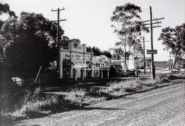
Photograph, Main Road, Lower Plenty at intersection of Old Eltham Road
View looking north across the main road towards the Lower Plenty shops showing the Lower Plenty Garage and store which was later developed into a Caltex service station, since demolished and replaced by a new Aldi supermarket.Black and white print Roll of 35mm colour negative film, 5 of 7 strips Kodak CP100 5094 and associated print Roll of 35mm black and white negative film, 3 strips Ilford FP4 and associated print Roll of 35mm colour negative film, 2 strips Kodak CP100 5094 and associated printaldi, caltex service station, lower plenty, lower plenty garage, lower plenty shops, main road, old eltham road, shops -
 Eltham District Historical Society Inc
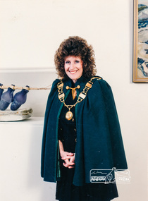
Photograph, Former Shire of Eltham President, Cr. Mary Grant with the Presidential Chain of Office
Cr. Mary Grant of Hurstbridge served as the North Riding Councillor for the Shire of Eltham. First elected in 1990 and required to retire by 1995. She was the Shire President at least 1992-1993. Source: Shire of Eltham 1993 Handbook. It is believed that this photograph was taken after Cr. Grant's term as President. EDHS Newsletter No. 216, May 2014, p4 Mayoral Chain of Office R.C. McLellan and family donated a Chain of Office to the Shire of Eltham to be worn by the Shire President on formal occasions. With the amalgamation of councils in 1994 this was transferred to the Shire of Nillumbik to be used during the mayoral year. Eltham had a Shire President whereas Nillumbik has a Mayor. Many municipalities have a collar or chain of office for ceremonial purposes. Traditionally these symbolise or denote the formal leadership role of office. This chain is part of the Visual Art Collection held by Nillumbik Shire Council and is now on display in the Council Chamber area in the Civic Centre at Greensborough. Matcham Skipper and Myra Skipper were commissioned by the McClellan family to create the gold-plated silver chain shown being worn by Eltham Shire President Peter Graham in 1990, with Bob McLellan and Matcham Skipper (centre). Nillumbik Shire Council has asked that the following credit information is used when the chain is displayed, or images reproduced. Matcham SKIPPER (1921-2011) and Myra SKIPPER (1920-1996) Mayoral (Presidential) Chains of Office 1976 Gold plated silver 60cm x 32cm x 1cm (variable) © The Estate of Matcham and Myra Skipper Donated by RC McLellan and Family Visual Art Collection: Nillumbik Shire Council [Picture: Nillumbik Mayoral Chain of Office] [Picture: Bob McLellan, Matcham Skipper and Eltham Shire President Peter Graham -1990]The Presidential Chain of Office is now a significant part of the Nillumbik Shire Council's art collection.Colour photograph Councillor Mary Grant in Shire President Regaliacouncillors, eltham shire council, shire presidents, mary grant, nillumbik shire art collection, presidential chain of office -
 Eltham District Historical Society Inc
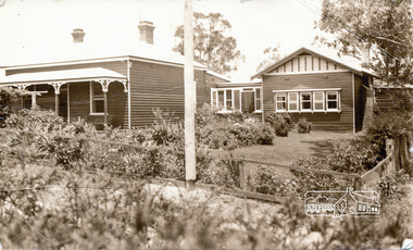
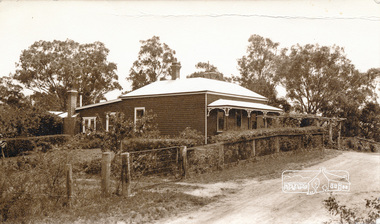
Photograph, Peter Bassett-Smith, 22 York Street, Eltham (renumbered 28), c.1933, 1933c
22 York Street, Eltham (re-numbered 28). One view north east from Bible Steet c.1933, the view of the house from the north c.1933. Original house of 4 rooms, weatherboard Baltic, line Baltic Pine, tongue and grooved boards and/or wall papered hessian. Skillion added c.1930, pitch roof room added c.1932. W.B. Bassett-Smith FRIBA Architect, W. Enright Builder. House in Bridge Street.Two sepia photographs of 22 York Street, Eltham, renumbered 28, former home of Bassett-Smith family.houses, york street, peter bassett smith -
 Eltham District Historical Society Inc
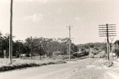
Photograph, Main Road, Eltham, looking north from Cecil Street, Oct. 1962
Main Road, Eltham looking north from Cecil Street; Diamond Street intersection in centre running to leftPhoto print B&Wmain road, eltham, diamond street, railway, cecil street -
 Eltham District Historical Society Inc
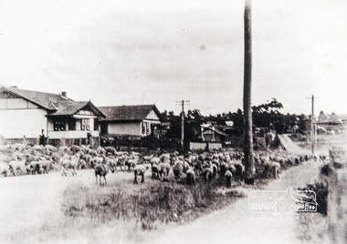
Photograph, Main Road, Eltham, looking south near Diamond Street, c.1937, 1937c
Two colour photograph copies of original images of Main Road, Eltham looking south from north of Diamond Street, c.1937 showing sheep being driven down the road towards station. Houses visible L-R: Lowerson's, Mowatt's, Mrs Pratt'smain road, eltham -
 Eltham District Historical Society Inc
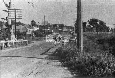
Negative - Photograph, Main Road, looking south near Diamond Street, Eltham, 1960c
Looking south from north of Diamond StreetRoll of 35mm black and white negative film, 3 stripsKodak Safety 5062main road, diamond street, eltham, cecil street, railway -
 Eltham District Historical Society Inc
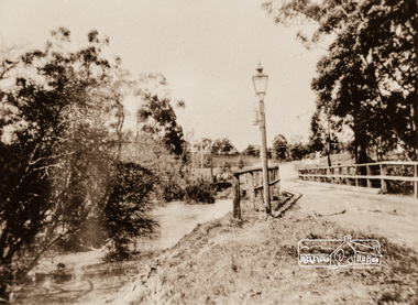
Photograph, Diamond Creek Bridge, Eltham North
Photograph copy of original showing the old Eltham North bridge upstream of present Wattletree Road bridgediamond creed, eltham north, wattletree road, coleman crescent, bridges -
 Eltham District Historical Society Inc
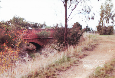
Photograph, Parsons Road bridge over former Maroondah Aqueduct
Colour photograph of Parsons Road bridge over disused Maroondah Aqueductparsons road, eltham north, research, aqueducts, maroondah aqueduct, bridges -
 Eltham District Historical Society Inc
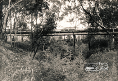
Photograph, Eltham North Bridge, 1970c
Black and white photograph from down in gully looking up at Wattletree Road Bridge over Diamond Creek, Eltham North c.1970bridges, diamond creek, wattletree road, eltham north -
 Eltham District Historical Society Inc
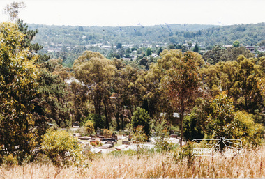
Photograph, Eltham from Eltham Cemetery, December 1984, 1984
Colour photograph of Eltham valley looking north west from Eltham Cemetery, December 1984eltham, eltham cemetery, cemeteries -
 Eltham District Historical Society Inc
Photograph, Peter Bassett-Smith, 22 York Street, Eltham, c.1933, 1933c
Two sepia photographs of 22 York Street (renumbered 28), Eltham from the north east. Formerly home of Bassett-Smith family c.1933 Original house of 4 rooms, Skillion added c.y W.B. Bassett-Smith FRIBA, Enwright, builder, Ivanhoeyork street, eltham, houses, peter bassett smith -
 Eltham District Historical Society Inc
Folder, Donald Ingersole, 1970s
Folder of information on Donald Ingersole, Councillor, North Warrandyte, 1970sdonald ingersole -
 Eltham District Historical Society Inc
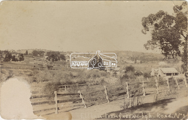
Postcard - Photograph, Eltham from Greensborough Road, No. 1, c.1910
The view is looking southeast from near Eltham Road (present-day Sherbourne Road) across Bolton and Bridge streets towards the village of Little Eltham running down the main road (Maria Street) . On the immediate right is Mrs Mary Jane Smart's family home located on the north side of Bridge Street at the intersection with Bolton Street, facing Bolton Street (now part of present day Brisbane Street and occupied by the Kitchen Design Centre). An original early settler's cottage, it was built by Mary Jane Smart's parents, Edwin Bailey and Jane (nee Matthews). Mary Jane Smart was born in the cottage. She married an Englishman, Alexander Wilson Smart who disappeared to Western Australia in the early 1900s in search of gold. He ultimately married again in W.A., committing bigamy and then committed murder and was hung in 1911. Visible at the top left are Watson's (two-storey) Eltham Hotel at the corner of Pitt Street and Maria Street and the Evelyn Hotel directly opposite.Sepia postcardNotations in biro 'A. Petrie', rest in pencil as follows St Margarets N end Shows Wesleyan Church Small Bank Double Storey on Hotel's south end Pearsons house Note roof structure Surface damage to lower left corner1910, bridge street, cba bank, church, clark bros. photo, early settlers, eltham, eltham hotel, evelyn hotel, fountain of friendship hotel, greensborough, mary jane smart (nee bailey), pearson house, pre 1900, road no 1, smart family home, smart home, st margarets, watsons hotel, wesleyan church