Showing 2159 items matching " reef"
-
 The Beechworth Burke Museum
Photograph
This image is a reproduction of an 1899 original depicting the 'Williams Good Luck Mine' on the Mopoke Reef (also called 'Morepork Gully') in the Dingle Ranges, approximately three miles from Beechworth. The foreground of the image is littered with piles of smashed rock and detritus, known as ‘mullock’, beside a reinforced mine shaft, a vertical access passageway allowing miners to enter the mine and haul ore out using lifting technology such as a poppet heads, whims or windlasses. A group of miners and a dog appear close to an open-sided miner’s hut. Following the discovery of gold at Beechworth in 1852, rushes quickly followed at surrounding creeks and gullies in the district. In the late nineteenth and early twentieth centuries, small syndicates of miners continued to work old or abandoned quartz reefs, often persisting without the assistance of heavy machinery to remove the large amounts of rock, in order to obtain yields at ever greater depths. The group of miners in this photograph are Mr. Roger Williams and Sons, who revived operations at the ‘Old Good Luck’ mine on the Mopoke Reef in the Dingle Range near Beechworth around 1892, working the site for more than two decades. An emigrant from Cornwall with experience in the tin mining industry, 19 year old Roger Williams senior sailed to New Zealand in 1840, then to Australia where he spent time in the Bendigo Gold Fields before settling in Beechworth in the early 1860s. Mr Williams senior worked on various mining activities in the district, including the Rocky Mountain Tunnel project. Conversant with the character of gold-bearing reefs in the area, the syndicate dug an eight hundred foot tunnel, digging down as far down as two hundred feet with little capital save their labour, to connect and provide better working access to the mass of reefs and veins in the vicinity. Progress was hampered by poor air quality charged with fumes from dynamite and large quantities of rock had to be crushed to obtain payable yields. The Victorian Goldfields are filled with ruins and remnants of the area's rich mining history, ranging from small alluvial diggings to the remains of huge mining companies. Site names often changed several times throughout the nineteenth and twentieth centuries. Some sites were abandoned and forgotten, others were worked continuously over many decades. The names of mines were often repeated at different locations throughout the Victorian Goldfields. For example, there is a Mopoke Gully heritage mine near Fryers Creek, Victoria. 'Mopoke' is a common onomatopoeic name for Morepork and Australian Boobook owls.This image has historical, social and research significance for patterns of emigration during of the Victorian Gold Rush, and the historical, social and environmental impacts of mining at Beechworth at the turn of the nineteenth and twentieth centuries. As gold became scarce and government support and large company investment waned, poor hard-working miners laboured intensively to make a living through periods of high unemployment. This image can be compared and studied alongside other historical mining photographs and objects in the Burke Museum Collection. It has potential to improve our understanding of miners working conditions and the shifting character of mining in the Beechworth district.Sepia coloured rectangular photograph printed on gloss photographic paper mounted on card.Obverse: Reverse: A02497/ 1997.2497/ 'Good/ Luck/ Mine'/ Morepork/ Gully/ Mrs Joyce/ Bright/ Tunnel/ 800 ft/ 1899. burke museum, beechworth museum, beechworth, gold fields, gold rush, victorian gold rush, gold ming history, colonial australia, australian gold rushes, mining technology, beechworth historic district, indigo gold trail, migration, indigo shire, good luck gold mine, victorian goldfields, mining syndicates, gold fever, quartz-mining, small-scale mining, old good luck mine, mopoke gully, quartz reefs beechworth -
 Bendigo Historical Society Inc.
Document - MCCOLL, RANKIN AND STANISTREET COLLECTION: SUNDRY REPORTS, 1930's
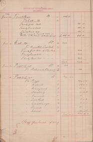
Manilla Folder containing reports from various mines in Bendigo and surrounding areas. 1. 4 page typewritten report on the Balaclava Hill Mine at Rushworth and some newspaper clippings about the mine with a plan of the underground workings; 2. Page from the Árgus' dated 2nd August 1900 featuring an article on the survey of the Garden line of Reefs; 3. 5 page report with maps on the Tooleen Gold Field; 4. Single page report about an unnamed mining area claimed to be on the southern end of the Deborah line of reef. (this could be the 'Three Jays' mine in Sedgwick. P. Wilkin); 5. Hand written report on the Coronation Mine, 2 miles east of Walhalla.; 6. Hand written report dated 1935, of the Queen Mary mine, St. Arnaud.; 7. 1932 report on the North Neangar lease.; 8 4 page report on the Kings Prize Gold Mining Syndicate.; 9. Description of the plant of the Marong Alluvial Company? Also a guide for marking out leases.; 10. Crushing details (1 page) from the 'Enterprise' Mine South of and adjacent to Perseverence.; 11. 1 page crushing details from Rowe Brothers, Mosquito Mine, Fryerstown.; 12 hand written report mentions Arthur Hatfield, Scarsdale.; 13. Map with lines of reef showing the position of the New Moon Consolidated and the New Moon United shafts.; 14, Large scale map from Harrison/Victoria street to Havilah Road showing the positions of the Carlisle, North Garden and Unity Shafts.gold mining, miners' safety cage, sundry reports, mining. bendigo, rushworth, balaclava hill, garden line of reef, toolleen, coronation mine, walhalla, queen mary mine, st. arnaud. north neangar, kings prize gold mining syndicate, marong, enterprise mine, perseverence, rowe brothers, mosquito mine, fryerstown, arthur hatfield, scarsdale, new moon consolidate, new moon united, carlisle, north garden, unity. -
 Bendigo Historical Society Inc.
Map - SECTIONS ACROSS BENDIGO GOLDFIELD
Map in three sections showing sections across Bendigo Gold Field, showing anticlines, synclines, faults, stratigraphical zones and mines along the reef lines. Key shows rock types Castlemaine, Bendigo B1, B2, B3 and B4, and Lancefieldian. First part of map shows sections A-A, B-B and C-C. Reef lines drawn with mines listed: Fault line shown are the Carshalton, Stafford, New Chum, Virginia and Clarence. A datum line shows 600 ft above sea level. On bottom of plan: ' Prepared in the Geological Survey Office, Bendigo, under the direction of H. Herman, late Director of Geological Survey, from surveys by H.S. Whitelaw, Field Geologist, assisted by E.S. Usher, A.J.J. Moore and R.A. Keble.' Second section of map shows sections D-D, and E-E. Fault lines listed are the Tambour Major fault, Carshalton fault, Stafford fault, Nell Gwynne fault, New Chum fault, Deborah fault. Third section shows sections F-F and G-G. Fault lines listed are the Bird Reef fault, Kangaroo Gully fault, Langdon fault, Carshalton fault, Nell Gwynne fault, Spring Gully fault, Hustlers fault, Gravel Hill fault, Ordes fault, Thanet fault. This map forms part of the Geological Survey of Victoria, Structure of Bendigo Goldfield report, No. 47, 1923. H.Herman, late Director of Geological Survey.Geological Survey of Victoriabendigo, gold mining, reef line maps -
 Bendigo Historical Society Inc.
Document - NEW CHUM RAILWAY MINE - GOLD MINES OF BENDIGO & EAGLEHAWK
Handwritten notes, and typed copy of same, on the New Chum Railway Mine and other mines and connections between various mines underground. Descriptions of mines and their equipment. Mines mentioned are: New Chum Railway Mine, Eureka Extended, Shenandoah, Shamrock Mine, Young Chum, Old Chum, Little Chum, New Chum Tribute, Cravens, Garibaldi, New Chum Consolidated, Menzies, Ellesmere, Consolidated, Denis, Lansell's 222, New Chum United, Kochs & Hildebrandt Mine, Lazarus, Central Blue, Lazarus No 1 Coy, Hudson's, Burrows & Sterry, Victoria Tribute, North Old Chum, Lansell's Big 180, Sandhurst, Victoria Quartz, The Great Central Victoria (known as the 'Midway'), Victoria Consols, Advance, Adventure, Ironbark, Victoria Gold Mines Company, No 83 claim, The Hercules & Energetic, North Energetic, Victoria Pilot, Bendigo Amalgamated Goldfields Company, Pearl, Hercules No 1, Hercules New Chum, Great Extended Victoria, New Victoria Catherine, Mystery (later the Duke of Edinburgh), New St Mungo, Duchess Tribute, Extended South Devonshire, South Devonshirte, Duchess of Edinburgh, Princess Alexandia (later United Devonshire), Danes, United Devonshire, South Devonshire, Hopewell, Phoenix, Unicorn, Lady Barkly, Sadowa, Eastwood Lease, Ellenborough, Belmont & Saxby, York & Durham, Acadia, Williams United, Ulster, North Red White & Blue, North Deborah, Catherine Reef United, Central Catherine, Princess Alice, Catherine Reef United, Murchison, North Catherine (or Franklin), Catherine Reef Extended,document, gold, gold mines of bendigo & eaglehawk, new chum railway mine, gold mines of bendigo & eaglehawk, eureka extended, shenandoah, shamrock mine, young chum, old chum, little chum, new chum tribute, cravens, garibaldi, new chum consolidated, menzies, ellesmere, consolidated, denis, lansell's 222, new chum united, kochs & hildebrandt mine, lazarus, central blue, lazarus no 1 coy, hudson's, burrows & sterry, victoria tribute, north old chum, lansell's big 180, sandhurst, victoria quartz, the great central victoria (known as the 'midway'), victoria consols, advance, adventure, ironbark, victoria gold mines company, no 83 claim, the hercules & energetic, north energetic, victoria pilot, bendigo amalgamated goldfields company, pearl, hercules no 1, hercules new chum, great extended victoria, new victoria catherine, mystery (later the duke of edinburgh), new st mungo, duchess tribute, extended south devonshire, south devonshirte, duchess of edinburgh, princess alexandia (later united devonshire), danes, united devonshire, south devonshire, hopewell, phoenix, unicorn, lady barkly, sadowa, eastwood lease, ellenborough, belmont & saxby, york & durham, acadia, williams united, ulster, north red white & blue, north deborah, catherine reef united, central catherine, princess alice, catherine reef united, murchison, north catherine (or franklin), catherine reef extended, mr clark magee, john delbridge - engineers, a harkness & sons, mr lansell, b c v 8 studios, mr gibbs, mr barnet lazarus, mt alvernia hospital, p m g repeater station, john brown knitwear, mr burrows, mr sterry, john wybrants, mr wittschiebe, theodore ballerstadt, mr wm rae, california hill state school, freeman & coy -
 Bendigo Historical Society Inc.
Document - CORRESPONDENCE TO BHS RE: CROCKER FAMILY
Correspondence to BHS re Crocker family - lived in Bendigo 1869 - 1912. Manager - Hustlers Reef mine. Reply from BHS: ''1891 - Mr Crocker was a member of the Mining Board''. A bracketed comment makes reference that the Mr. Crocker referred to in this letter may not have been the to which you refer. The reply make reference to a Mr. Crocke who attended the opening service of the Wesleyan School-house, situated at View Point Sandhurst.person, individual, crocker family, james thomas croker, king edwards, hustlers reef mine, mining board, wesleyan school-house, view point sandhurst. -
 Bendigo Historical Society Inc.
Document - BOOTH ST MCKENZIE MINING
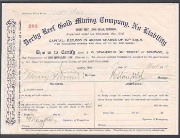
Derby Reef Gold Mining Company No Liability scrip dated 4th April 1912 certifying that J G Stanfield holds 100 shares in above-named company located in Long Gully, Bendigo. Capital of 20,000 pounds in 40,000 shares at 10 shillings each. J G Stanfield signature indicates he was manager of above -named company. Director signatures illegible. Scrip pasted upon cardboard backing. Unknown donorbendigo, gold mining, j g stanfield -
 Bendigo Historical Society Inc.
Document - MCCOLL, RANKIN AND STANISTREET COLLECTION: DEBORAH GOLD MINES NL- WAGES BOOK, 1945-50
Document: McColl, Rankin and Stanistreet: Deborah Gold Mines NL - wages book various mining companies. Hardcover, green. Wages and tax paid for employees of North Deborah, North Deborah Battery 1 and 2, Nell Gwynne Reef, North Virginia, Central Deborah, Deborah Gold Mines, Deborah Battery, Central Nell Gwynne, North Deborah Battery No. 3. On front cover in gold ' Collins Analysis Book, 27 sets'organization, mining, mccoll, rankin and stanistreet, mccoll, rankin and stanistreet: deborah gold mines nl, gold mining, bendigo, wages book -
 Bendigo Historical Society Inc.
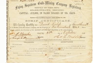
Document - LANSELL COLLECTION: SCRIP CERTIFICATE: FLYING SQUADRON GOLD-MINING COMPANY REGISTERED, 1870
Document: 2 copies of Scrip certificates from Flying Squadron Gold-Mining Company Registered, Woodfield and Pigeon Reefs, Sparrowhawk, Bendigo. Issued to David Field of Sandhurst, 26th. October, 1870. Signed by J.G. Weddell, Manager. David Field is listed as an original shareholder in the Flying Squadron Mine, in 1870. ( see Government Gazette October 7, 1870 ) The mine was situated at Sparrowhawk Gully, Sandhurst. ** one copy only in pocket. 8.10.2019place, fortuna, family history, bendigo, sandhurst, fortuna, lansell, david field -
 Bendigo Historical Society Inc.
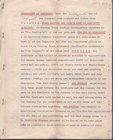
Document - MCCOLL, RANKIN AND STANISTREET COLLECTION: MEMORANDUM OF AGREEMENT GREAT EASTERN AND BIRDS REEF, 10/2/1933
Document: McColl, Rankin & Stanistreet , 7 page document, typed, prepared by Ford Aspinwall & DeGruchy, Solicitors, Melbourne. Memorandum of agreement between Great Eastern and Birds Reef No Liability syndicate and New Don No Liability. Signed under common seal of New Don James Barclay and Geo. Kingsley ( director ) and Stanistreet ( legal manager ) Also asigned by Jack Reginald Ingram, Thomas Watson Haynes and Henry George De Gruchy.organization, business, new don no liability, mccoll, rankin & stanistreet , great eastern and birds reef no liability syndicate, new don no liability, bendigo, gold, goldmining, lease -
 Bendigo Historical Society Inc.
Document - MCCOLL, RANKIN AND STANISTREET COLLECTION: ASSAY CERTIFICATES, 1930's
Manilla Folder Held together with brass pins containing Assay Certificates from S. R. Mitchell & Co. Pty Ltd. The Majority of them are for L. C. Stuckey Esq. 199 Barker Street Castlemaine and a few of them are for Sir Herbert Gepp 422 Collins Street Melbourne. Also contains a list os samples taken from Reefs near the Devonshire Mines Castlemaine. The Dates range from 1935 to 1937.S. R. Mitchell & Co., Pty, Ltd. Metallurgists. 399 Little Colins Street, Melbourne.gold, mining, metallurgists, gold mining, castlemaine, s.r. mitchell, l.c. stuckey, sir herbert gepp -
 Tarnagulla History Archive
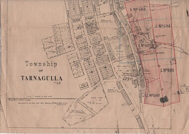
Linen-Backed Map of Tarnagulla Dated 1860 with Updates, Including Mining Leases
This is a very nice linen-backed map first published in 1860 and progressively updated, the latest being 1924 at the time of Government boring on the Poverty Reef. The map clarifies details of the mining leases as they stood in 1924, and the map also identifies previously uncertain details such as the location of the battery well, and also the location of the 1909 syndicate to the south of the Sandy Creek Co's shaft. The lightly pencilled location of the Birthday shaft is incorrect. This mine was located further to the east. -
 Bendigo Historical Society Inc.
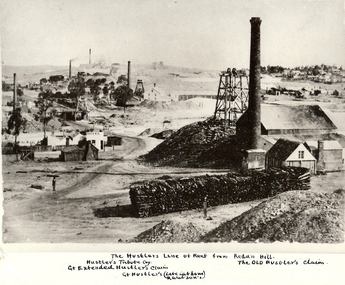
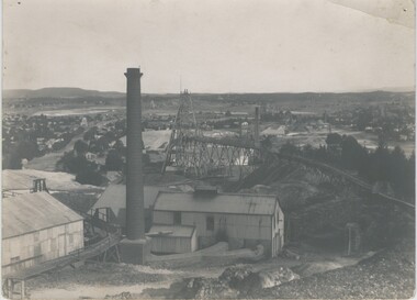
Photograph - HUSTLER'S LINE OF REEF
BHS CollectionBlack and white photograph of mining landscape with poppet head, chimney and mining sheds (plus timber in stack) in foreground. Other mines in bare landscape on LHS background and housing on RHS background. Inscriptions: on front - 'The Hustler's Line of Reef from Redan Hill Hustler's Tribute Coy', 'Gt. Extended Hustler;s Claim', 'The Old Hustler's Claim, Gt. Hustlers (Late Latham & Watson's). On back - 'A Richardson, 29 Harrison Street, Bendigo'.mine, gold, hustlers reef mine, bendigo, mines and mining, mine, mines, mining, landscape, mining landscape, redan hill, poppet head, old hustlers, mining cottages -
Bendigo Historical Society Inc.
Document - MINING REPORTS - FAMOUS GOLD MINES OF BENDIGO AND EAGLEHAWK
Handwritten notes by Albert Richardson, titled 'Famous Gold Mines of Bendigo and Eaglehawk'. Notes include gold yields, deep shafts in 1904 and 1911, shafts of more than 4,000 feet, shafts between 3.020 and 3,682 feet and the reef line they were on, wages for different mine workers and a reference to winding engines and air compressors. Miner's mentioned: Ballerstadt, Wittscheibe, Lufffmans, Burrows, Sterry, Lazarus, Koch, Hidebrandt, Watson and George Lansell.gold, mining reports, mining reports, famous gold mines of bendigo and eaglehawk, the victoria quartz, new chum railway, miners wages, albert richardson -
 Bendigo Historical Society Inc.
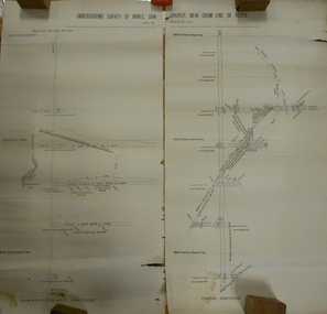
Document - MARKS COLLECTION: UNDERGROUND SURVEY OF MINES NEW CHUM LINE OF REEFS
Plan, in two sections, on heavy parchment coloured paper. Printed across top in black ink 'Underground Survey of Mines New Chum Line of Reefs' a. Shows cross section of mine, b. longitudinal section. Drawn by Arthur Everett, Mining Department, Melbourne 1884. Surveyed by Caleb Thomas under the direction of Charles Langtree. Plan found in George Lansell auction items. Plan found in George Lansell items sold at auction.bendigo, mining, new chum reef -
 Bendigo Historical Society Inc.
Document - LANSELL'S BIG 180 MINE - CONDENSED HISTORICAL RECORD OF LANSELL'S BIG 180 MINE
Two handwritten and three typed copies of a Condensed Historical Record of Lansell's Big 180 Mine on the New Chum Line of Reef. Notes include location, shaft, first worked, size of lease, plant, engine house, boiler rooms, mullock heap, early history, Prominent, best gold, underground connections, pressurised hot water, diamond drill bores and a table with depths and the increase in temperature with the depth (in Fahr). Albert Richardson Collection. document, gold, lansell's big 180 mine, lansell's big 180 mine, condensed historical record of lansell's big 180 mine, wittscheibe, ballerstadt, ernst mueller, theodore ballerstadt, george lansell, north old chum, victoria quartz, mines dept special edition 'australian mining standard' 1/6/1899, mines dept booklet 'bendigo goldfield' 1936, quarterly reports, lansell's 180 mine 'transverse sections, annals of bendigo mining sections, a richardson's observations from old photographs and measurements of mining plans, measurements taked from caleb thomas' report mines dept 1875, 'report on observation of underground temperature at bendigo' james stirling government geologist 1899, a richardson -
 Bendigo Historical Society Inc.
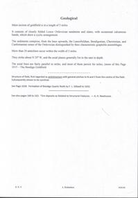
Document - MINING REPORTS - GEOLOGICAL REPORT OF MAIN SECTION OF GOLDFIELD
Handwritten notes by Albert Richardson, with typed copy, on a Geological report of main section in a length of 5 miles. Report mentions sandstones and slates, with occasional calcareous bands, which show a cyclic arrangement. Also mentioned are different zones of sediments, anticlines, structure of the field and references: Page 1028 Formation of Bendigo Quartz Reefs by F R Stilwell to 1032 and pages 160 to 163 'Ore deposits as Related to Structural Features - A H Newhouse. document, gold, mining reports, mining reports, geological report of main section of goldfield, the bendigo goldfields page 1015, formation of bendigo quartz reefs by f r stilwell page 1028 to 1032, ore deposits as related to structural features pages 160 to 163 a h newhouse -
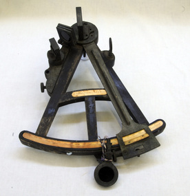 Orbost & District Historical Society
sextant, W. Sutherland
RIDGE PARK, Length: 65.2 m.; Owned by H. Simpson & Sons; Built at S. P. Austin & Sons in 1878. Registered at Adelaide. On 10 February 1881, RIDGE PARK (Capt. Heslop) was on voyage from Adelaide to Sydney with a cargo of brandy, wine and flour, when she was lost after running aground.Beware Reef is located south east of Cape Conran in east Gippsland. This is the sextant from the Ridge Park which, on10 February 1881, was wrecked on Beware Reef , just south of Cape Conran in east Gippsland. An old wooden sextant from the ship, Ridge Park. It is black with yellow measuring stripes.sextant maritime navigational -
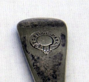 Orbost & District Historical Society
cutlery, 1880's
RIDGE PARK, Length: 65.2 m.; Owned by H. Simpson & Sons; Built at S. P. Austin & Sons in 1878. Registered at Adelaide. On 10 February 1881, RIDGE PARK (Capt. Heslop) was on voyage from Adelaide to Sydney with a cargo of brandy, wine and flour, when she was lost after running aground.Beware Reef is located south east of Cape Conran in east Gippsland.This cutlery is from the Ridge Park which, on 10 February 1881, was wrecked on Beware Reef , just south of Cape Conran in east Gippsland.Two forks and two spoon which are silver plated dinner cutlery.On front of handles - S.S.Ridge Park On back of handles - EP & NS with an A inside a circle -
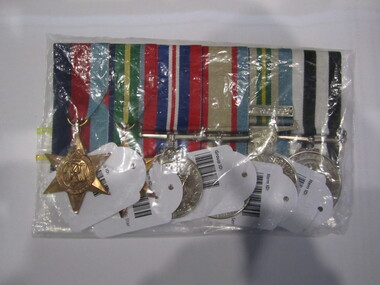 Ballarat RSL Sub-Branch Inc.
1939 - 1945 Star
This object relates to Richard TRUDGEON. He was born on 1/06/1888 in Newstead, VIC. Richard served in the AIF (2502) enlisting on, 08/05/1916 in Welshman's Reef, VIC before being killed in action on duties with the 46 BATTN as a Army Non-Commissioned Private (PTE) on 11/11/1917. Richard TRUDGEON was not a prisoner of war. His next of kin is Richard TRUDGEON (Father).second world war (ww2), 1939 - 1945, medals, ballarat rsl, ballarat -
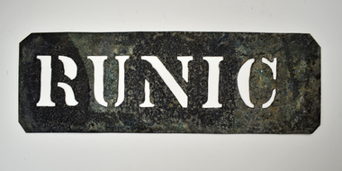 National Wool Museum
Stencil - RUNIC
This stencil was used as a ship identifier stamp for the transportation of wool bales. SS Runic was the largest refrigerated cargo liner during its time. In 1961 the ship struck the Middleton Reef on route from Brisbane to Auckland. The ship was unable to re-float due to weather conditions and was declared a constructive loss. All wool bales stamped with RUNIC would be transported on the SS Runic ship.Wool bale export stencil - RUNICRUNICwool transportation, wool export, wool sales -
 Bendigo Historical Society Inc.
Administrative record - Spring Gully Gold Mining Co. Fryerstown, Minute Book1903 - 1915, 1924 - 1929
The Spring Gully Gold Mining property consists of Gold Mining Lease No. 2986, Castlemaine, of about 21 acres situated on the Emu Reef, in Spring Gully Fryers. There are two shafts, distant about 300 feet from each other. From one of them large quantities of gold were obtained in former years by previous companies. ( Prospectus of the Spring Gully Mining CompanyMaroon hard cover book, brown leather binding on spine and corners, three hundred and eighty pages. Written on spine of book in gold leaf : 'Minute Book'. Handwritten minute entries from 14th September 1903 to 30th August 1915. Affixed to first page, newspaper clipping from the 'Herald' 13/9/05, with information about the Spring Gully Mine Fryerstown. Page eighty-one has two quotes affixed from 'The Yarraville Chlorination and Ore Reduction Works' High Street Yarraville, July 1905, for works associated with pyrites and blanket sand. Page nine, a handwritten letter affixed to minutes, applying for a block of land 250 feet north of main shaft. Signed by J.S. Potter, H. Hancock, G Murray and T. Tumney. 1.Page one hundred and one: three quotes from 'Edwards' Metallurgical Works' Specimen Hill, Bendigo for pyrites and blanket sand. 2.Page one hundred and fifty five: handwritten letter (copy) from A. Schonfelder re shaft work on the mine and mention of tributors 3. Affixed to inside cover: letter from the 'United Shire of Mount Alexander' April 15th. 1907, regarding the reconstruction of the Vaughan bridge over the Loddon River. 'the benefit that the mines in your district derive from the bridge being open for wood waggons and this being the main traffic and this being the principal cause of the bridges present condition'. 4. Prospectus of the Spring Gully Mining Company, Spring Gull, Fryerstown, two page folded document enclosed inside back cover of book. Prospectus incomplete. (10746.93a) 5. Carbon copy of letter to D.E. Williams Esq, Castlemaine from GlenAthol, Casewick Road, London, January 25th, 1907 regarding two gentlemen who were 'called upon to carry the 'Spring Gullys' through - Mr. H. 'is making a determined effort to bring the matter to a successful issue' Letter signed by George Allan. (10746.93b. 6. Carbon copy of letter from E. Williams, London re proposed new company to acquire the properties of Spring G.M. Coy, Spring Gully G.M. Coy. No. 1, Sth Spring Gully G.M. Coy, Sth Spring Gully G.M. Coy Extended (10746.93c) 7. Handwritten letter to the Chairman and Directors of the Spring Gully G.M. Co. re the appointment of 'Mr. Samuel Morse Battery Manager at once, or accept my resignation as Mining Manager, for we can't agree any longer' Signed by A. Schonfelder. 8. Notice of extraordinary meeting of shareholders in Spring Gully Gold Mining Company No Liability, 22nd November 1906 at Beehive Chambers, Bendigo. Signed W.G. Blackham (Blackham & Garvin) Manager of the Company. (10746.93e) The Minute Book is part of the Margaret Roberts Collection of mining documents.bendigo, margaret roberts, , goldmining, castlemaine, spring gully gold mine, fryertown -
 Bendigo Historical Society Inc.
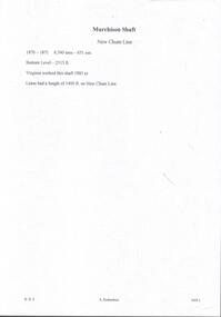
Document - MURCHISON SHAFT
Victorian Heritage Database Report Report generated 03/03/25 MURCHISON SHAFT Location LESTER STREET SAILORS GULLY, GREATER BENDIGO CITY Municipality GREATER BENDIGO CITY Level of significance Heritage Inventory Site Heritage Inventory (HI) Number H7724-0192 Heritage Listing Victorian Heritage Inventory Other Names NEW CHUM REEF, Hermes Number 8493Handwritten notes with typed copy, on the Murchison Shaft on the New Chum Line. 1870 - 1871. 6,7 tons - 651 ozs. Bottom Level - 2315 ft. Virginia worked this shaft 1883 to -. Lease had a length of 1400 ft. on New Chum Line.document, gold, murchison shaft, virginia -
 Bendigo Military Museum
Photograph - RASvy Surveyors in the field, c1950s – 1960s
This is a set of 1photographs of surveyors in the field measuring distances using chains, taking observations using theodolites and operating electric distance measurement equipment. They were probably employed in establishing mapping and geodetic control operations or the surveyors may have been in training. The photos were most likely taken in the 1950s and 1960s. Photos .1P to .6P feature personnel setting up geodetic survey chaining equipment to measure distances. The surveyor in Photo .5P is LTCOL Howard Angus Johnson MBE who served from 1936 to 1954. The RA Svy surveyor in photos .7P to .12P were using a theodolite to take angular measurements. They were usually supported by an observer who recording their readings on a booking form. The surveyor in Photo .10P and .11P is LTCOL Jorge Gruszka, who served from 1955 to 1985. He was CO of the Army Survey Regiment from 1982 to 1985. The surveyor in photo .13P is cutting an identification blaze on a tree using a hammer and chisel. The tellurometer in Photos .14P to .16P was a MRA1 microwave Electronic Distance Measuring instrument (EDM) introduced in 1958. It and later models were man-portable systems that improved geodetic survey efficiencies for rapid network extension and densification replacing triangulation with EDM and theodolite traverse sometimes using Bilby Towers to extend line lengths. The surveyor with the slouch hat is Colonel James ‘Jim’ Leslie Stedman, who served from 1941 to 1978. He was Director of Military Survey from 1975 to 1978 and was appointed as Colonel Commandant (honorary appointment, Retd) of the Royal Australian Survey Corps from 1978 to 1983. Jim Stedman is demonstrating EDM equipment.This is a set of 17 photographs of surveyors in the field measuring distances using chains, taking observations using theodolites and operating electric distance measurement (EDM) equipment. c1950s – 1960s. The photographs were printed on photographic paper and are part of the Army Survey Regiment’s Collection. The photographs were scanned at 300 dpi. .1) - Photo, black & white, c1950s, unidentified personnel using geodetic survey chaining equipment. .2) to .4) - Photo, black & white, c1950s, geodetic survey chaining equipment. .5) – Photo, black & white, c1950s, Jim Stedman using geodetic survey chaining equipment to measure distances. .6) - Photo, black & white, c1950s, Unidentified personnel geodetic survey chaining equipment. .7) – Photo, black & white, mounted on card, c1950s. Unidentified surveyor undertaking observations on a coral reef using a theodolite. .8) – Photo, black & white, c1950, unidentified surveyor undertaking observations with a Tavistock theodolite. .9) – Photo, black & white, mounted on green card, c1950s. Unidentified surveyor undertaking observations using a plane table. .10) – Photo, black & white, c1955, Jorge Gruszka undertaking observations with a theodolite. 7/55 Basic Survey Course Balcombe. .11) – Photo, black & white, c1950s, Jorge Gruszka undertaking observations with a theodolite. .12) – Photo, black & white, c1946-1948, unidentified surveyor undertaking observations with a theodolite to gain control for the mapping of the Snowy Mountain Diversion Scheme. .13) – Photo, black & white, c1950s, unidentified surveyor cutting a blaze in a tree. .14) and .15) – Photo, black & white, c1960s, Jim Stedman demonstrating EDM equipment. .16) – Photo, black & white, c1960s, L to R: Jim Stedman (probably) and unidentified surveyor demonstrating EDM equipment. .17) – Photo, black & white, 1956, Operation Cutlass - Surveyors SPR W. Crane and J.A. Campbell undertaking observations with a theodolite in extreme conditions..1P on back - First Order Chaining Equipment .2P on back - First Order Chaining Equipment .3P on back - Full catenary 1800 – 1960 replaced by EDM .4P on back - First Order Chaining Equipment .5P on back - H.A. Johnson, Benambra baseline? 1st Order Chaining .6P on back - Chaining .7P on front - Difficult observing conditions especially when the tide is in. The station is sighted (sic) on a coral reef. .8P on back - Tavistock. .10P on back of duplicate in Photo Folder 14 – George (sic) Gruszka 7/55 Basic Survey Course Balcomme (sic) 1955/56 .14P and .15P on back - Jim Stedman demonstrating early EDM equipment.royal australian survey corps, rasvy, army survey regiment, army svy regt, fortuna, asr, surveying -
 Bendigo Historical Society Inc.
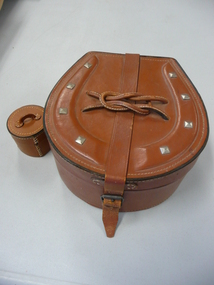
Accessory - LEATHER COLLAR CASE
Leather collar case in a horse-shoe shape (impressed leather 'shoe' with 'nails' on top). Top has stiched leather thin 'rope' in the form of a reef knot over the leather strap that closes the box. Hinged with single leather strap. Lining is a fine blue cotton material. A central circular leather stud box with leather handle has broken away from the internal base (due to very firm fitting lid to box?). 1920s-1930s?personal effects, containers, collars -
 Bendigo Historical Society Inc.
Photograph - LANSELL'S 222 MINE
black and white photo: Lansell's 222 mine. Various poppet heads in distance, chimney, poppet head and mine buildings in foreground. On back of photo: 'Lazarus Enginehouse; 3,650 ft. ' Lansell's 222. Taken from Old Chum Hill. New Chum Line. ' View from Chum looking at the 222 mine - Sheepshead Line of Reef on left. ( J. Lerk 26.11 1999 ) Bottom right hand Corner A Richardson 29 Harrison Street BendigoVincent Kelly Bendigo - embossed bottom right corner.organization, business, lansell's 222 mine -
 Bendigo Historical Society Inc.
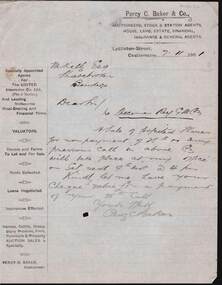
Document - KELLY AND ALLSOP COLLECTION: LETTER FROM PERCY C. BAKER TO M.KELLY, 07/11/1901
Document. KELLY & ALLSOP COLLECTION. One page handwritten letter, dated 7 Nov. 1901, from Percy C. Baker, Auctioneer of Lyttleton St., Castlemaine to M.Kelly Esq, Sharebroker, Bendigo. Relates to sale of forfeited Specimen Reef G.M.Co., shares for non payment of call. Auction to take place at Baker's office on 9th Nov. Letter written under Percy C. Baker & Co. printed letter head that outlines all the functions of tPercy C. bakerbusiness, stockbroker, kelly & allsop, kelly & allsop collection, percy c. baker, m.kelly, letter, specimen reef gold mining co. -
 Bendigo Historical Society Inc.
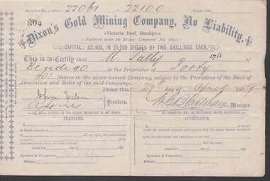
Document - KELLY AND ALLSOP COLLECTION: SHARE CERTIFICATES - DIXON'S GOLD MINING CO, 08/11/1895 to 27/04/1899
Document. KELLY & ALLSOP COLLECTION. Two share certificates issued by Dixon's Gold Mining Company, No Liability, Victoria Reef, Bendigo. Both certificates issued to M.Tully of Bendigo. Certificate No. 439 - 100 shares @ 2 shillings each issued on 8 Nov.1895. Certificate No. 804 - 40 shares @ 2 shillings each issued on 27 April 1899. Capital raised was 2,400 Pounds from 24,000 shares. Each certificate signed by W.G.Blackham, Manager.Dixon's Gold Mining Co.business, stockbroker, kelly & allsop, kelly & allsop collection, share certificates, dixon's gold mining co., m.tully, w.g.blackham, victoria reef. -
 Bendigo Historical Society Inc.
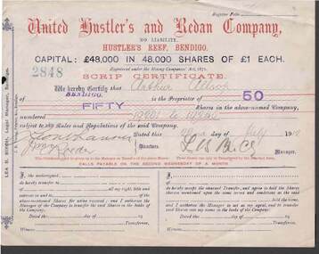
Document - KELLY AND ALLSOP COLLECTION: SHARE CERTIFICATES - UNITED HUSTLER'S & REDAN COMPANY, 22/07/1912 to 26/10/1914
Document. KELLY & ALLSOP COLLECTION. 2 Share Certificates issued by the United Hustler's and Redan Company, Hustler's Reef, Bendigo. Each certificate represents 50 shares at One Pound each. Capital raised was 48,000 Pounds from 48,000 shares. Certificate No. 2848 issued to Arthur Allsop of Bendigo on 22 July 1912. Certificate No. 2620 issued to A.Allsop of Bendigo on 26 Oct 1914. Both certificates signed by Lea B.Birch, Legal Manager.United Hustler's & Redan Co.business, stockbroker, kelly & allsop, kelly & allsop collection, united hustler's & redan co., gold mining, share certificates, arthur allsop, lea b.birch -
City of Kingston
Photograph - Colour, 31 January 1993
Patterson Lakes is a suburb in the City of Kingston that is built one kilometre upstream of the mouth of the Patterson River. The area is bordered by the Patterson River and Eel Race Drain which enters the Kananook Creek. The suburb consists predominantly of newer housing developments and the tidal canal system of the development joins Port Phillip Bay. Patterson Lakes and the Kananook Creek were previously part of the extensive Carrum Carrum Swamp. The area was once a source of fish and eels for the Mayone-Bulluk clan of the Bunurong people. Over time the area was drained and in 1973 investigations commenced into the development of a unique residential area that would be built adjacent to canals and waterways. It was originally proposed to be known as "Gladesville". The development would give the suburb's homeowners access to Port Phillip Bay "from their back door". Circa 1974, the area was rezoned from rural to residential and named Patterson Lakes. Development has been continuous since the 1970s with construction of residential housing, schools, shopping centres, marinas, a hotel and library.Laminated colour aerial photograph of the Carrum and Patterson Lakes region within City of Kingston. This 1993 image includes Patterson River Secondary College, Roy Dore Reserve, Kananook Creek and Nepean Highway. The railway line can be seen as it veers inland from Eel Race Road, Seaford. The section of Ocean Reef Drive and Palm Beach Drive in Patterson Lakes appears to be a recent development with many spare blocks and new houses under construction.Black typed lettering on white adhesive label: 31.1.93 Black typed lettering on white adhesive label: 27E/7140 31/1/93 12.55 pm Black typed lettering on white label: 7140 Yellow round adhesive label located on left sidepatterson lakes, seaford, kananook creek, carrum carrum swamp, canals and waterways -
 Bendigo Historical Society Inc.
Administrative record - Catherine Reef Extended Mining Co. and Kingsley's Reward Mining Co. journal, 1919 - 1920
Maroon soft cover book. Inside front cover 'Journal' printed in black pencil. Six pages of financial records entries for Catherine Reef Extended Mining Co. dating from December 12th, 1905 to 17th April, 1911. One page of financial records for Kingsleys Reward Mining Co. N.L., showing unalloted shares, uncalled capital and mine account . Mine Manager's book forms part of the Margaret Roberts Collection of Mining records.bendigo, margaret roberts, legal managers, mine manager, east moon gold mining company n.l., e.g. robertson mine manager, alfred jorgensen contractor, paddy's gully shaft, derby shaft, hustler's shaft,