Showing 3828 items
matching survey
-
 Greensborough Historical Society
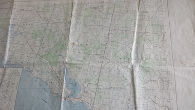
Map, Victoria: Yan Yean, prep. by Australian Section of Imperial General Staff, 1935
Part of 1:63,360 series of survey mapsColour copy from original. Scale: 1: 63,360 (1 inch to 1 mile) 2 copiesRev. 1930 by Australian Survey Corps using RAAF Air Photos. yan yean -
 Greensborough Historical Society
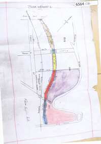
Map, Poulter Avenue transverse, 1900 c
This is a survey of land acquired from William Haylock Poulter for the construction of Poulter Avenue. Includes area of River Estate and part of Poulter Reserve, Carter Street, Flintoff Street and Plenty River.1 p. photocopy of traverse survey printed in colourSigned by William Haylock Poulterpoutlter avenue greensborough -
 Peterborough History Group
Map - Government map, Government Printer, Port campbell, 1957
Aerial survey map showing roads, vegetation and other landscape features.Significant because it shows the detail of the region in 1957Original 1957 State Aerial Survey Map of Port Campbell region, including Peterboroughpeterborough, aerial survey map, maps, port campell -
Bendigo Historical Society Inc.
Map - GEOLOGICAL MAP OF BENDIGO GOLD FIELD
Two framed laminated maps (a,b) of Bendigo goldfield reef lines, map (b) is a continuation of the reef lines in map (a). On map(a) written in black on top: 'Geological Map, Bendigo Gold Field', Scale of chains, anticlines, synclines, shafts, alluvial and contours marked. Map (b) is continuation of (a). Written on the bottom RH corner of map: 'Prepared in 1923 in the Bendigo Office Mines Department under the direction of H. Herman, Director of Geological Surveys, from surveys by H.S. Whitelaw, Fiield Geologist, assisted by E.S. Usher & J. J. Moore. Re-issued in 1936.'H. Herman, Director of Geological Surveys, from surveys by H.S. Whitelaw, Fiield Geologist, assisted by E.S. Usher & J. J. Moore. Re-issued in 1936.'bendigo, mining, geological map. -
Whitehorse Historical Society Inc.
Map, Blackburn East Primary School
Proposed master plan 1955?Proposed master plan 1955? With Public Works Dept. detail survey 1979. Rolled map.Proposed master plan 1955? blackburn east primary school no. 4800, public works department -
Whitehorse Historical Society Inc.
Map, Parish of Nunawading, 1927
Map of the Parish together with part of the Borough of Box Hill.Map of the Parish together with part of the Borough of Box Hill. Includes names of lease or license holders, sizes of leases and in some areas dates of leases. Roads, railway and stations marked. Original survey by W.J.Busocon, 1915. Manuscript note: 15.2.1927 Verified Dept. Lands and Survey.Map of the Parish together with part of the Borough of Box Hill. maps, parish of nunawading, borough of box hill -
Federation University Historical Collection
Plan, Ballarat Common, c 1890
Hand drawn ink plan or field notes for a survey on faintly ruled foolscap paper. Field notes or survey depicting Ballarat Commons, Ballarat Botanical Gardens, Police Paddock and Ballarat Cattle Yards Railways area. 'R.W.' at bottom, Verso 'Ballarat' with various calculations. -
Bendigo Historical Society Inc.
Map - HUSTLERS LINE OF REEFS - LONGITUDINAL SECTION THROUGH THE SADDLE REEFS
Drawing with Longitudinal Section through the Saddle Reefs along portion of Hustler's Line of Reefs, Bendigo. Map shows the depth of the mines, reef numbers and Datum 700 ft above sea level. North and South is also noted on the map. Map signed by H. S, Whitelaw, Underground Survey Office, Bendigo, September 1913. Bulletin No 33, Plate No XXXIV. Bendigo Creek, Ironbark Creek and Long Gully are also noted. Mines are: Fortuna Hustlers, Hustler's Royal Reserve No 2 Main Shaft, Hustler's Royal Reserve No 2 Park Shaft, Royal Hustler's, Imperial Hustler's, Extended Hustler's Freehold, Great Extended Hustler's Tribute (Pups), Old Shaft, Great Extended Hustler's Reef No 2, Great Extended Hustler's Main Shaft, Old Shaft, Hustler's Reef, Hustler's Reef No 1, Comet, K. K., United Hustler's & Redan, Old Shaft and Hustler's Consols. Has Geological Survey of Victoria Crest and underneath is: H. Herman, Director, W. Dickson, Secretary for Mines, The Hon. J Drysdale Brown M L C. Minister of Mines.Geological Survey of Victoria Crestmining, parish map, hustler's reef maps, hustlers line of reefs, bendigo creek, ironbark creek and long gully are also noted. mines are: fortuna hustlers, hustler's royal reserve no 2 main shaft, hustler's royal reserve no 2 park shaft, royal hustler's, imperial hustler's, extended hustler's freehold, great extended hustler's tribute (pups), old shaft, great extended hustler's reef no 2, great extended hustler's main shaft, old shaft, hustler's reef, hustler's reef no 1, comet, k. k., united hustler's & redan, old shaft and hustler's consols.h s whitelaw, underground survey office bendigo september 1913, bulletin no 33 plateno xxxiv, mi -
 Greensborough Historical Society
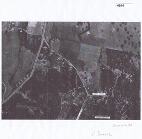
Aerial Photograph, Greenhills Aerial View, 1945_
Section from the 1945 aerial survey of Greensborough, including part of Diamond Creek Road, Greenhill Road, Crest Street and Albion Crescent.Photocopy of part of 1945 aerial survey. Some streets have been marked.greenhills -
Bendigo Historical Society Inc.
Document - LANDS OFFICE, REPORTS OF SALES BY PUBLIC AUCTION, 1864 - 1892
Document: buff leather hard covered journal. On spine on red rectangle ' Land sales by public auction' written in gold. On bottom of spine 'Lands and Survey' written in gold on black. On base of spine '4' printed in black. Pages contain details of sales of crown lands by public auction Act 25, Victoria 145. Alphabetical index of counties inside front cover. 443 numbered pages. LH side columns, number, county, parish, section, allotment sold, unsold, price. RH page - improvements, purchaser, residence, amount, later sales have printed notices pasted in. Dated 27 April 1864 to 7 October 1892.Lands and Survey Dept.place, bendigo, public auction, bendigo, sandhurst, crown land, public land auctions, land sales. -
 Halls Gap & Grampians Historical Society
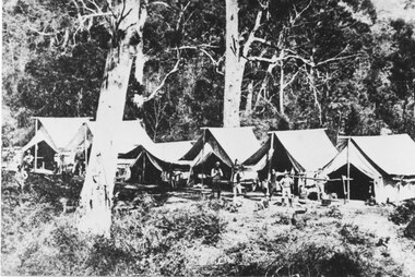
Photograph - B/W
Railway survey camp 1880 After choosing the route, the rail survey was undertaken followed by the construction of the line in less than a year. By Nov 1881 access by rail for Heatherlie to Melbourne was a reality Railway survey camp Heatherlie quarry; 11 men, some standing, some reclining in front of 6 army style tentsstructures, tents -
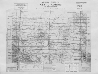 The Beechworth Burke Museum
Photograph - Aerial Survey, 5/9/1947
This image is an Aerial Survey, Key Diagram of Beechworth and surrounding area. Issued by Department of Lands and Survey, Victoria in 1947. Photographed at an average height of 12300 feet above sea level, areas depicted are; Beechworth, Stanley, Bruarong, Baranduda, Muagegonga, Myrtleford, Everton, Wooragee North Tarrawinge, Dederang, Kergunyah North, Kergunyah, Yackandandah, El-Dorado, Barambogie, Murmungee, Barwidgee, Oxley, CarraragarmungeeBlack and white rectangular photograph. Image is printed on matt photographic paper and has a white un-printed border. Obverse: AERIAL SURVEY, KEY DIAGRAM OF PHOTOGRAPHS, APPROXIMATE SCALE OF MILES / DEPARTMENT OF LANDS AND SURVEY VICTORIA 5.9.1947. BEECHWORTH 792 ZONE 7. Reverse: BMM7010.1 (written in pencil) aerial survey, beechworth, burke museum, department of lands and survey, victoria, 1947 -
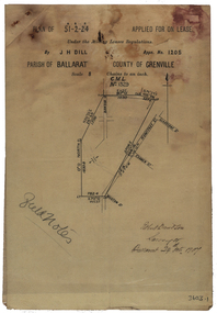 Federation University Historical Collection
Plan, Parish Of Ballarat Mining Lease applied for by J.H. Dill, 1907, 24/10/1907
Removed from Catalogue No 3601.Lease, plan and field notes showing the survey for the New Kohinoor Comapny Lease No 1205. Scale: 8 chains to 1 inch (1:6336)new kohinoor, survey, robert davidson, j.h. dill, dill, mining, ballarat, new koh-i-nor -
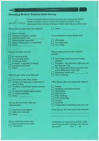 Emerging Writers' Festival
2006 Emerging Writers' Festival Survey
The 2006 Emerging Writers' Festival was the third EWF. Surveying and understanding the wants and needs of audiences has always been an important part of programming for the following year at the EWF.A green A4 page with printing on both sides that surveys participants of the 2006 Emerging Writers' Festival.2006 emerging writers' festival, steve grimwade, literary program, the wheeler centre, emerging writers', literary, festival, melbourne -
Whitehorse Historical Society Inc.
Map, Burwood Road, Box Hill City, 15/02/1952 12:00:00 AM
Plan of subdivision of ten blocks in Burwood Road, Burwood.Plan of subdivision of ten blocks in Burwood Road, Burwood between Milford Avenue and Station Street. Marked as Survey Plan No 5441.Plan of subdivision of ten blocks in Burwood Road, Burwood. land subdivision, burwood road, burwood, milford avenue, burwood, central court, burwood -
Whitehorse Historical Society Inc.
Map, Burwood Road, Box Hill City, 15/02/1952 12:00:00 AM
Plan of subdivision of 19 blocks in Burwood Road, Burwood.Plan of subdivision of 19 blocks in Burwood Road, Burwood between Greenwood Street and Middleborough Road. Marked as Survey Plan No 5442.Plan of subdivision of 19 blocks in Burwood Road, Burwood. land subdivision, burwood road, burwood, greenwood street, burwood, middleborough road, burwood -
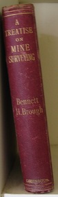 Parks Victoria - State Coal Mine - Wonthaggi
Book, "A treatise on mine surveying", C 1913
A. Part of the George Hadden collection B.Descibes in detail all aspects of mine surveying"A treatise on mine surveying" Hard Bound, red cover, gold lettering, 372 pages plus a 60 page advertising supplement.Inside front cover: "A.Blackburn Shottou Colliery Co. Durham.", "G.Hadden" -
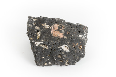 The Beechworth Burke Museum
Geological specimen - Basalt, Unknown
Basalt is a common igneous rock that composes most of the Earth's surface and can be found on the Moon and other rocky planets of the Solar System. It is generally composed minerals such as calcic plagioclase, clinopyroxene and iron ore which form grains that are indistinguishable to the naked eye. It can be dark grey or black in colouring and sometimes may contain holes left by gas bubbles. Most of the Earth's basalt was produced in environments such as oceanic divergent boundaries, oceanic hotspots, and mantle plumes and hotspots beneath continents. Basalt is commonly used in construction where it is crushed and used for multiple purposes such as concrete aggregate, road base, or railroad ballast. Thin slabs of basalt can also be cut and used for floor tiles, stone monuments, and building veneer. This particular specimen was excavated from Talbot in Victoria, which was a small gold mining town established in 1852. As basalt is a common rock, it is not specific to Talbot. However, this specimen can be assumed to be of the Cainozoic age due to previous geomorphic surveys of the area. This particular type of Basalt was used mainly for roads due to the durability of the rock.Basalt holds significance due to the continued use of the rock from historic until present times. The rock has been utilised for many types of construction and is still used for the same purposes today. Basalt also has significance to the Earth and other rocky planets of the Solar System as it makes up most of the planet's surface. This specimen is part of a larger collection of geological and mineral specimens collected from around Australia (and some parts of the world) and donated to the Burke Museum between 1868-1880. A large percentage of these specimens were collected in Victoria as part of the Geological Survey of Victoria that begun in 1852 (in response to the Gold Rush) to study and map the geology of Victoria. Collecting geological specimens was an important part of mapping and understanding the scientific makeup of the earth. Many of these specimens were sent to research and collecting organisations across Australia, including the Burke Museum, to educate and encourage further study.A smaller than hand sized rock specimen which is dark grey in colour with small holes and white deposits across its surface.Geological survey / [illegible] /burke museum, beechworth, geological specimen, geology, basalt, basalt specemin, indigo shire, talbot, cainozoic, igneous rock -
Glenelg Shire Council Cultural Collection
Photograph - Photograph - Aerial Photo railway line between Heywood and Rennick, 03/05/1952
Victorian Railways aerial survey record print of the railway line between Heywood and Rennick (S.A. border) Black and white, white vertical strip on imageBack: 'Heywood - Rennick 21357 - 19628 258m 16c' - all black ink. Purple VR aerial survey stamp. '3 May 1952' - black stamp -
Glenelg Shire Council Cultural Collection
Photograph - Aerial Survey Railway Record Print – 1952, 03/05/1952
Victorian Railways aerial survey record print of the railway line between Heywood and Rennick (S.A. border) Black and white, white vertical strip on image.Back: 'Heywood - Rennick 21072 - 19363 235m44c Heywood' - all black ink. Purple VR aerial survey stamp. '3 May 1952' - black stamp -
Glenelg Shire Council Cultural Collection
Photograph - Photograph - Aerial Photo railway line between Heywood and Rennick, 03/05/1952
Victorian Railways aerial survey record print of the railway line between Heywood and Rennick (S.A. border) Black and white, white vertical strip on imageBack: 'Heywood - Rennick 21395 - 19666 261m 49c ' - all black ink. Purple VR aerial survey stamp. '3 May 1952' - black stamp -
Glenelg Shire Council Cultural Collection
Photograph - Photograph - Aerial Photo railway line between Heywood and Rennick, 03/05/1952
Victorian Railways aerial survey record print of the railway line between Heywood and Rennick (S.A. border) Black and white, white vertical strip on imageBack: 'Heywood - Rennick 21385 - 19656 260m 53c' - all black ink. Purple VR aerial survey stamp. '3 May 1952' - black stamp -
Glenelg Shire Council Cultural Collection
Photograph - Photograph - Aerial Photo railway line between Heywood and Rennick, 03/05/1952
Victorian Railways aerial survey record print of the railway line between Heywood and Rennick (S.A. border) Black and white, white vertical strip on imageBack: 'Heywood - Rennick 21220 - 19501 248m Heywood' - all black ink. Purple VR aerial survey stamp. '3 May 1952' - black stamp -
Glenelg Shire Council Cultural Collection
Photograph - Photograph - Aerial Photo railway line between Heywood and Rennick, 03/05/1952
Victorian Railways aerial survey record print of the railway line between Heywood and Rennick (S.A. border) Black and white, white vertical strip on imageBack: 'Heywood - Rennick 21384 - 19625 257m 67c ' - all black ink. Purple VR aerial survey stamp. '3 May 1952' - black stamp -
Glenelg Shire Council Cultural Collection
Photograph - Photograph - Aerial Photo railway line between Heywood and Rennick, 03/05/1952
Victorian Railways aerial survey record print of the railway line between Heywood and Rennick (S.A. border) Black and white, white vertical strip on imageBack: 'Heywood - Rennick 21294 - 19866 254m 19c ' - all black ink. Purple VR aerial survey stamp. '3 May 1952' - black stamp -
Glenelg Shire Council Cultural Collection
Photograph - Photograph - Aerial Photo railway line between Heywood and Rennick, 03/05/1952
Victorian Railways aerial survey record print of the railway line between Heywood and Rennick (S.A. border) Black and white, white vertical strip on imageBack: 'Heywood - Rennick 21431 - 19794 274m 18c ' - all black ink. Purple VR aerial survey stamp. '3 May 1952' - black stamp -
Glenelg Shire Council Cultural Collection
Photograph - Photograph - Aerial Photo railway line between Heywood and Rennick, 03/05/1952
Victorian Railways aerial survey record print of the railway line between Heywood and Rennick (S.A. border) Black and white, white vertical strip on imageBack: 'Heywood - Rennick 21580 - 19843 279m 65c ' - all black ink. Purple VR aerial survey stamp. '3 May 1952' - black stamp -
Glenelg Shire Council Cultural Collection
Photograph - Photograph - Aerial Photo railway line between Heywood and Rennick, 03/05/1952
Victorian Railways aerial survey record print of the railway line between Heywood and Rennick (S.A. border) Black and white, white vertical strip on imageBack: 'Heywood - Rennick 21448 - 19719 266m 56c ' - all black ink. Purple VR aerial survey stamp. '3 May 1952' - black stamp -
Glenelg Shire Council Cultural Collection
Photograph - Photograph - Aerial Photo railway line between Heywood and Rennick, 03/05/1952
Victorian Railways aerial survey record print of the railway line between Heywood and Rennick (S.A. border) Black and white, white vertical strip on imageBack: 'Heywood - Rennick 21382 - 19653 260m 33c ' - all black ink. Purple VR aerial survey stamp. '3 May 1952' - black stamp -
Glenelg Shire Council Cultural Collection
Photograph - Photograph - Aerial Photo railway line between Heywood and Rennick, 03/05/1952
Victorian Railways aerial survey record print of the railway line between Heywood and Rennick (S.A. border) Black and white, white vertical strip on imageBack: 'Heywood - Rennick 21449 - 19720 266m 64c ' - all black ink. Purple VR aerial survey stamp. '3 May 1952' - black stamp