Showing 1248 items
matching bay road
-
 Port Melbourne Historical & Preservation Society
Document - Notice, Attendance at deputation to Public Work re Williamstown Road grant, Edward Clark, Town Clerk, 27 Jan 1880
Pinned with item 600.02Small (4pg) notice inviting attendance at deputation to Minister of Lands, 28 January 1880 re sale of lands along Williamstown Short Road'(Copy)'town planning, edward clark, town clerks, george f smith, land sales -
Port Melbourne Historical & Preservation Society
Document - Notice, Date of deputation to Minister of Lands re sale of lands along Williamstown Short Road, 23 Jan 1880
Pinned with item 600.01Small (4pg) letter from Town Clerk Williamstown to E.C. Clark, notifying date of deputation to Minister of Lands, re sale of lands along Williamstown Short RoadE.C. Clark address is in black (rest of letter in mauve ink)town planning, edward clark, town clerks, george f smith, land sales -
Port Melbourne Historical & Preservation Society
Photograph - Barbara HEGARTY behind her father, Bill HEGARTY's, holden on country road, 1950s
Photo of Barbara (Hegarty) GARDINER behind Bill HEGARTY's Holden on country roadtransport - motor vehicles, barbara gardiner nee hegarty, william (bill) hegarty -
Port Melbourne Historical & Preservation Society
Book - Collins Melbourne Street Directory, 1950s
From Glen Stuart - used by his father, William Raeburn Stuart.Collins Melbourne Street Directory c1950stransport - roads, william raeburn stuart -
Port Melbourne Historical & Preservation Society
Document - Submission, Inquiry into "Land Transport to Webb Dock", 1981
Submissions concern impacts, implications and future directions regarding freight movement into and out of Webb Dock.Submissions and transcripts from the State Development Committee "Inquiry into Land Transport to Webb Dock", 1981 City Of Port Melbourne submissionport of melbourne authority, transport - railways, transport - roads, local government - city of port melbourne, webb dock, urban freight group, bill saggers -
Port Melbourne Historical & Preservation Society
Document - Submission, Inquiry into "Land Transport to Webb Dock", 1981
Submissions concern impacts, implications and future directions regarding freight movement into and out of Webb Dock.Submissions and transcripts from the State Development Committee Inquiry into "Land Transport to Webb Dock", 1981 Bill Saggers submission"Bill Saggers highlighted aspects of the written submission to be presented verbally by Bill Saggers"port of melbourne authority, transport - railways, transport - roads, local government - city of port melbourne, webb dock, urban freight group, bill saggers -
Port Melbourne Historical & Preservation Society
Document - Submission, Inquiry into "Land Transport to Webb Dock", 1981
Submissions concern impacts, implications and future directions regarding freight movement into and out of Webb Dock.Submissions and transcripts from the State Development Committee "Inquiry into "Land Transport to Webb Dock", 1981 Urban Freight Group submission"RPW"port of melbourne authority, transport - railways, transport - roads, local government - city of port melbourne, webb dock, urban freight group, bill saggers -
Port Melbourne Historical & Preservation Society
Document - Transcript, Inquiry into "Land Transport to Webb Dock", 1981
Submissions concern impacts, implications and future directions regarding freight movement into and out of Webb Dock.Submissions and transcripts from the State Development Committee "Inquiry into "Land Transport to Webb Dock", 1981 Transcript of Proceedings, 25.08, 1981"RPW"port of melbourne authority, transport - railways, transport - roads, local government - city of port melbourne, webb dock, urban freight group, bill saggers -
Port Melbourne Historical & Preservation Society
Archive - File, Safer Routes to Shops in Port Melbourne, 2000 - 2001
This project involved community representatives in the identification of unsafe points on the route between Wintringham Hostel and Bay Street, in particular for elderly and disabled people. The intention of the project was to improve coordination between departments of Council viz. Health & Safety with Infrastructure. The lack of coordination that was a legacy of contracting-out was evident throughout the project.File of documents, reports, correspondence, photos relating to the project "Safer Routes to Shops in Port Melbourne" (between Wintringham Hostel and Bay Street) 2000-2001engineering - roads streets lanes and footpaths, matt rodda, jim hillis, perce mcguire white, perce white -
Port Melbourne Historical & Preservation Society
Photograph - Entrance, Port Melbourne Football Ground, Williamstown Road, John May, 1996
A record shot taken by John May on restructuring of VFA, indicating inclusion of Traralgon in the league.Colour snapshot of Williamstown Road entrance to Port Melbourne football ground with sign indicating first game with Traralgon after club's entrance into the VFL (Victorian Football League, formerly VFA) Two copiessport - australian rules football, port melbourne football club, pmfc -
 Port Melbourne Historical & Preservation Society
Photograph - Beachfront towards Princes Pier late 1980s, Alison Kelly, 1990
Photographed by Alison Kelly while she was joint caretaker of the building during the Mission Arts Centre days 1987 to 1991From album of photos mostly by Alison Kelly: Missions to Seamen building, view from Beach Road to western side of chapelmissions to seamen, built environment, princes pier -
Port Melbourne Historical & Preservation Society
Photograph - Missions to Seamen, Port Melbourne, Alison Kelly, 1990
Photographed by Alison Kelly while she was joint caretaker of the building during the Mission Arts Centre days 1987 to 1991From album of photos mostly by Alison Kelly: Missions to Seamen building, view from Beach Road and Swallow Street to eastern side of chapel; bottle brush plants in foregroundmissions to seamen, built environment, alison kelly -
Port Melbourne Historical & Preservation Society
Photograph - Relocated and damaged cornerstone, Missions to Seamen, Port Melbourne, Bob Gooding, Jul 2015
During demolition of the 1937 Missions to Seamen building in October 1995, this stone was removed intact by developers Mirvac Victoria, and placed in the care of the PMH&PS.Photograph taken by member Bob Gooding showing severe damage to the stone on July 2015 Cornerstone laid at the Missions to Seamen building, Beach Road and Swallow Street, in 1937. Now located in the seawall surrounding the carpark at the foot of Nott Stmissions to seamen, harry a norris, lord huntingfield -
 Port Melbourne Historical & Preservation Society
Photograph - Aerial view of first Bank Houses in Garden City, 1927
Photographic copies from black and white aerial photograph of the building of the first State Savings Bank Houses in Garden City 1927, showing also Graham Street State School, Princes Pier, Graham Street and Williamstown Road, west wing of Station Pier ("Rotomahana" at pier)built environment - domestic, fishermans bend, garden city, education - primary schools, melbourne harbor trust - port of melbourne authority, state savings bank of victoria, graham street state school, port melbourne primary school, bank houses -
Port Melbourne Historical & Preservation Society
Photograph - Tanker filling station at BP Oil Depot, Port Melbourne, Douglas Smallpage, 1970s
Black and white photograph of the road tanker filling station at B P Oil Depot, Port Melbourne (originally COR Oil Co)built environment - industrial, commonwealth oil refineries, cor, bp australia -
Port Melbourne Historical & Preservation Society
Photograph - Beach Road protest against Bayside Project, Port Melbourne, Peter Weaving, 26 Nov 1987
Black and white photograph of residents blocking Beach Road to advise motorists of its imminent closure as part of the 'Bayside' project, 1987town planning - proposals shelved - bayside, public action campaigns, swallow & ariell ltd, sandridge city development co pty ltd, scdc -
Port Melbourne Historical & Preservation Society
Document - Blueprint, portable stonebreaker, Austral Oitis Engineering Company, 1913
Blueprint of portable stonebreaker designed 1913 by Australia Otis Engineering of South Melbourneengineering - roads streets lanes and footpaths, business and traders, austral otis engineering co pty ltd, stonebreaker -
Port Melbourne Historical & Preservation Society
Negative - Negative, Barak Road Development Area Services plan, City of Port Melbourne, City of Port Melbourne, Barak Road Development Area Services, 27 Sep 1971
4" x 5" negative of City of Port Melbourne plan, Sept 1971, of services required for development between Barak and Beacon Roadstransport - railways, town planning, local government - city of port melbourne -
Port Melbourne Historical & Preservation Society
Photograph - Port Melbourne foreshore, Elizabeth Cromb, 1990s
Photographed by Betty CROMB, who lived at corner of The Boulevard and Barak Road, after wetlands had been created by the cleanup of the BP site. Before the building of Beacon Cove.One of two colour photos Port Melbourne foreshore, taken and sent by Elizabeth CROMB: Beacon Cove site pre-development. City skyline in background. View toward inland beacon and temporary wetlands soon to become Beacon Cove (The supplementray file is a letter from the donor)natural environment, beacons, town planning, built environment, piers and wharves - station pier, piers and wharves - princes pier, transport - ferries, elizabeth cromb, beacon cove -
Port Melbourne Historical & Preservation Society
Photograph - Port Melbourne foreshore, Elizabeth Cromb, c. 1992
Photographed by Betty Cromb, who lived at corner of The Boulevard and Barak Road; horses were often turned out here on their way to or from race meets on the Abel TasmanOne of two colour photos Port Melbourne foreshore, taken and sent by Elizabeth Cromb: Time when horses would come off the "Abel Tasman" from Tasmania from a race meeting.. Grazing on foreshore before returning home.natural environment, built environment, piers and wharves - station pier, livestock, transport - ferries, elizabeth cromb, horses -
Port Melbourne Historical & Preservation Society
Letter - Elizabeth Cromb re photographs of Port Melbourne foreshore, Elizabeth Cromb, 1999
Sent by Betty Cromb, who lived at corner of The Boulevard and Barak Road, with photos she'd taken at the foreshoreNote that accompanied two colour photos Port Melbourne foreshore, taken and sent by Elizabeth Cromb, 1999natural environment, elizabeth cromb -
Port Melbourne Historical & Preservation Society
Photograph - Grades 2,3,4 City Road Primary School, South Melbourne, 1931
Lasercopy of photo loaned by Doug McKenzie: grades 2, 3, 4, City Road Primary School (South Melbourne)1931education - primary schools, joyce bennett mckenzie, city road primary school -
Port Melbourne Historical & Preservation Society
Photograph - Rainbow, 488 Williamstown Road, Port Melbourne, David Thompson, Jul 1986
Colour photograph of David and Liana Thompson's home in Williamstown Road July 1986, rainbow overheadbuilt environment - domestic, liana thompson, david thompson -
 Port Melbourne Historical & Preservation Society
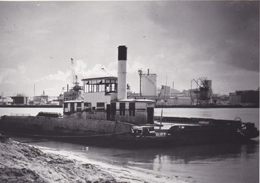
Photograph - Williamstown 'Short' Road ferry, laying at south side of the Yarra prior to being broken up, 1970s
Black and white photographic copy from slide of Short Road Ferry laying at south side of Yarra, prior to being broken uptransport - ferries -
 Port Melbourne Historical & Preservation Society
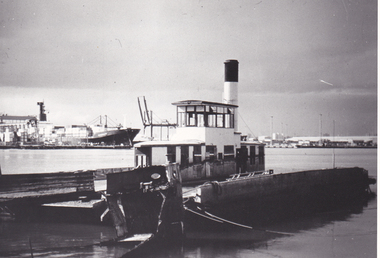
Photograph - Williamstown 'Short' Road ferry, laying at south side of the Yarra prior to being broken up, 1970s
Black and white photographic copy from slide of Short Road Ferry laying at south side of Yarra, prior to being broken uptransport - ferries -
Port Melbourne Historical & Preservation Society
Book, Ministry of Planning & Environment, South Melbourne's Heritage, Dec 1988
Based on "City of South Melbourne Urban Conservation Study". Covers 1930s - 1960s.Paperback, illustrated guide to the history and development of South Melbourne "South Melbourne's Heritage" A4 sized book with coloured cover and blurred style picture of two women and children on Kerferd road pier in 1890s. Victoria Hotel in background. Book contains small black and white photos of buildings with descriptionsemerald hill, town planning, heritage, city of south melbourne -
 Coal Creek Community Park & Museum
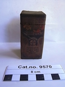
Box, medicine, post 1930 after the new town of Leverkusen was named
Email from "Heike Dansard" Only two specimens remain in the Bayer archival collection. ref: email in 'Historical Information'.Oiled rectangular thick cardboard box with printed text on paper label on outside containing white crystalline powder. Top of box lifts off as lid.On box top : BAYER BAYER' as a cross with 'Y" as the centre set in a circle in a square margin. side 1. 'CYCLOFORM FabinFabriken orm (?) FRIEDR.BAYER & Co leverkusen a/ Coln a/ Rh pharmaceohscbe.......'. Side 2. ......'CYCLOFORM............BASYER BAYER Brevate et nom depose en Allamagne et dans la pluparet des autres pays industrials'. (translation : Patent name and deposited in Germany and most other industrial countries). Side 3. ' ......Weiderwerkaul..................in...........CYCLOFORM.........MARKE BAYER BAYER..................Name.....MARKE..................und.............ichgeschuzt.........ubrigon.anaesthetic -
 Coal Creek Community Park & Museum
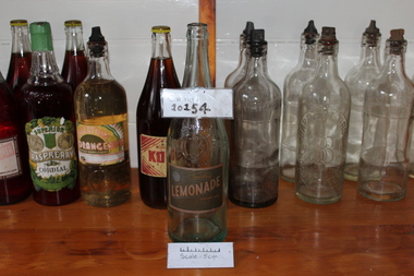
Lemonade
Tall slim Glass Bottle Air Bubbles above where the logo isBendigo Swan Hill Sparkling Lemonade Preservative added C.B BROS.COHN The Property of the cohn bros vic bay Co LTD Bendigo & Swan Hill -
 Port Melbourne Historical & Preservation Society
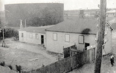
Photograph - Original Port Melbourne Swimming Club Building, c. 1920
In the 1920's West Beach Swimming Club was located at the corner of Beacon Road & the Boulevard in Garden City. The main hall was a men only facility with the women using in the smaller building at the rear. Situated next to the hall is the Commonwealth Oil Refinery storage tank.B & W photograph of large wooden hall with a smaller hall to the rear. In the 1920's it was used by the West Beach Swimming Club.On reverse - Original Port Melbourne Swimming Club.sport - swimming, port melbourne swimming club, west beach swimming club -
 Port Melbourne Historical & Preservation Society
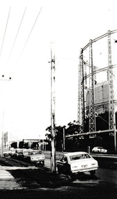
Photograph - Graham Street towards Albert Park, Reverend Donald LANGFORD, June 1973
Taken from the corner of Seisman Place looking towards Albert Park, the photograph was taken before the demolition of the gasometer shown on the on right. The original Albert Park High School can be seen behind the Pickles Street sign.B & W photograph of Graham Street, Port Melbourne looking towards Pickles Street.built environment - demolition, built environment - industrial, transport - roads, education - secondary schools, gasometer