Showing 2091 items
matching bendigo maps
-
 Bendigo Historical Society Inc.
Map - PETER ELLIS COLLECTION: MAP OF WHIPSTICK
... Inc. History House 11 Mackenzie Street Bendigo goldfields MAP ...Two maps of the Whipstick - Sheet A and Sheet B. Sheet A shows the Whipstick in relation to Bendigo and some surrounding places. Bitumen roads, gravel, forest tracks, Mallee Areas, Flagstaff Hill, fenced in reservations and reservoirs are marked. Also a circle and part circles of 5, 10, 15 and 20 mile radius are marked. North & South are marked. Sheet B is an enlarged area of the Whipstick Scrub area. North and South is marked. There are a number of letters written over both maps.map, bendigo, whipstick, peter ellis collection, the whipstick, flagstaff hill -
 Bendigo Historical Society Inc.
Document - PETER ELLIS COLLECTION: SKETCH OF THE BARFOLD GORGE
Two hand sketched maps on same sheet of paper, one of the location of the Barfold Gorge in relation to surrounding towns, Mt Alexander and Turpin;s Falls. The second map is a part of the Campaspe River location of the Barfold Gorge. Shown is the location of columns, pools, type of rock, Mitchell's Falls, tunnel, cave, Queen's Falls, house, windmill, fences and places where access to the bottom of the gorge is possible. Car track and scale of 1 mile = 6 inches are also shown.place, land, barfold gorge, peter ellis collection, mitchell's falls, queen's falls, turpin's falls -
 Bendigo Historical Society Inc.
Document - PETER ELLIS COLLECTION: A GUIDE FOR DRIVERS ON THE WHIPSTICK TOUR
... for the tour on Sunday September 9th (no year). A Whipstick Map 1971...Bendigo Historical Society Inc. Bendigo Historical Society ...A Guide for Drivers on the Whipstick Tour. First page gives assembly area, driving in convoy and negotiating water or boggy patches across the road. Amended written at the end of the page. Directions with mileage and items of interest for the tour on Sunday September 9th (no year). A Whipstick Map 1971 showing State Forest, Crown Lands, Uncleared Mallee - Private (shown in different colours) Water Reserve and Roads. Noted are Flora and Fauna - Plants, Birds & Mammals, and areas of State Forest and Southern State Forest with Mallee Scrub area noted. Also State Forest & Crown Lands Total Area and a map scale. The Bendigo Whipstick mentions area, suggestions of where the name Whipstick came from, shrubs and flowers with their flowering times, descriptions of some of them and some information on the Mallee Fowl. The Eucalyptus Oil Industry paragraph mentions the beginnings of the industry. Mentioned are the different uses of oils (perfumery, industrial and medicinal) and the different species of eucalypt used for each and various products. Also notes on the growing, harvesting and refining of eucalyptus. P Ellis at the end of the page. The next two and a half pages mentions reserves, and at the end acknowledgements. Includes a spare copy of 'The Bendigo Whipstick' by P Ellis.bendigo, history, early bendigo, peter ellis collection, a guide for drivers on the whipstick tour, the whipstick 1971 map, shire of marong, shire of east loddon, shire of huntly, borough of eaglehawk, city of bendigo, shire of strathfieldsaye, the bendigo whipstick, eucalyptus oil industry, eaglehawk town hall, lightning hill lookout, eaglehawk rifle range, new moon mines, blue jacket reservoir, maggetti's wine hall, camp hotel (ex), skylark dam, eucalyptus oil production, eucalyptus factory, whipstick eucalyptus farm, ruedin's eucalyptus factory, dutch bowls, governor philip, sir joseph banks, john white, baron von mueller, joseph bosisto, commonwealth government, perfumery oils, industrial oils, medicinal oils, p ellis, dr frith, csiro wildlife division, harley webster, forests commission, vincent serventy, victorian national parks association, bendigo field naturalists club -
 Bendigo Historical Society Inc.
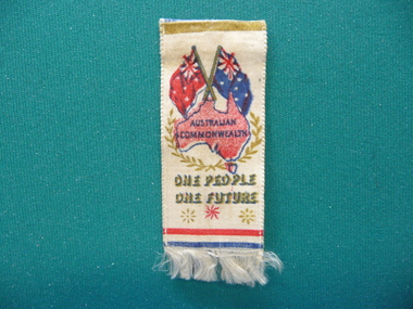
Souvenir - FEDERATION STICK PIN, 1901
Federation Stick pin with ribbon of white satin with map of Australia underneath Australian & Red Ensign flags, worded Australian Commonwealth One People One Future, fringed on bottom.event, official, federation -
 Bendigo Historical Society Inc.
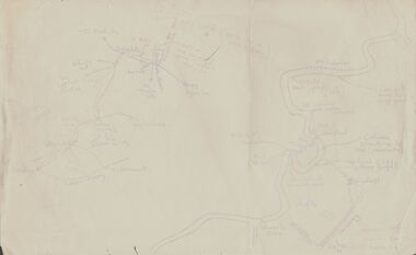
Document - PETER ELLIS COLLECTION: BUSH DANCE AND MUSIC CLUB BENDIGO, September
Three Bush Dance & Music Club of Bendigo & District Newsletters, Sept 1989 (yellow), October 1989 (green) and December 1989 (yellow). Newsletters contain contacts, Coming Events, dance programs and September 1989 edition has a map of how to get to the Notley's Picnic area. Also reports and in the October edition a sketch of how to get to a picnic area in the Wellsford Forest. The December issue has the contacts, Christmas Break-up and next meeting. On the back is the monthly dance dates for 1990.clubs, music, bush dance & music club of bendigo, peter ellis collection, bush dance & music club of bendigo & district, wayne blandford, mary smith, gary clancy, marg lapham, notley's reserve, reservoir hotel, wedderburn old timers, harry mcqueen & friends, lorraine ogilvie, mike jackson, val wilson, barry simpson, peter ellis, victorian folk music club, shirley andrews, john meredith -
 Bendigo Historical Society Inc.
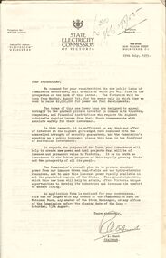
Document - MERLE BUSH COLLECTION: VARIOUS DOCS
Various docs (possibly from Bush Collection?) a. Public issue of State Electricity Commission securities - letter to Stockholders; Power Loans ; Cash and Conversion Loans 1954/55; b. Board of Works Cash Loan Prospectus 1956; c. Card with information re the MMBW Metropolitan Farm; d. two B&W interior photos of St. Davids church, Hobart; e. J C Williamson Magazine programme 1934; f. Melbourne & Metropolitan Tramways Board -map of proposals for General Scheme 1923.ephemera, mementoes, general interest -
Bendigo Historical Society Inc.
Document - MARKS COLLECTION: STRATHFIELDSAYE PLAN 1854
... Inc. History House 11 Mackenzie Street Bendigo goldfields MAP ...Plan drawn on light paper. Written on LH side of plan 'Plan of Part of the Parish of Strathfieldsaye 1854. Scale (shown) Lithographed at the Surveyor Generals Office, Melbourne July 10th. By I. Jones'. Plan shows Emu Creek and Village Reserve at top of plan, Shepherd's Creek on RH side, Parish Boundary Line on RH and bottom of plan.map, bendigo, shire of strathfieldsaye 1854 -
Bendigo Historical Society Inc.
Document - MARKS COLLECTION: SECTION OF MAIN CHANNEL
Plan drawn on waxed type paper, fragile. Written in centre of map 'Section on Centre of Main Channel , Scale horizontal 2 chs, vertical 10ft., to an inch'. Plan shows Melbourne Road on top section. Written in red ink '5,000,000 galls in 24 hours = 3472.2 gals per minute'. Plan located in documents from George Lansell auction.bendigo, mining, water channel section -
 Bendigo Historical Society Inc.
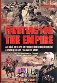
Book - FIGHTING FOR THE EMPIRE
Fighting for the Empire, an Irish doctor's adventures through imperial campaigns and two world wars, the life and times of Thomas Bernard Kelly 1870-1949. Hard cover with dust jacket published by Sabrestorm, 240 pages with colour and black & white photographs and maps. Chapter 2 relates to Bendigo through Michael an older brother.David Worsfoldbooks, biography, kelly -
Bendigo Historical Society Inc.
Document - MARKS COLLECTION: MAP OF EAGLEHAWK/LONG GULLY AREA
... Inc. History House 11 Mackenzie Street Bendigo goldfields Map ...Map of Eaglehawk and Long Gully area. Maps shows allotments and areas. Map is split down centre (torn ?) and in two pieces. Map was located in Fortuna papers, potentially belonged to G. Lansell. Section of map has been neatly cut out - area near Mt Korong Road and Victoria Hill. -
 Bendigo Historical Society Inc.
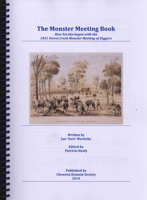
Book - THE MONSTER MEETING BOOK
The Monster Meeting Book, how Eureka began with the 1851 Forest Creek monster meeting of diggers, written by Jan'Yarn' Wositzky edited by Patricia Healy published by Chewton Domain Society 2014, in a spring bound binder with 171 pages containing coloured illustrations, photographs and maps.Jan Wositzkyvictoria, history, monster meeting chewton -
 Bendigo Historical Society Inc.
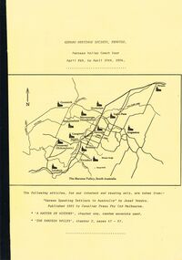
Document - GERMAN HERITAGE SOCIETY COLLECTION: BAROSSA VALLEY COACH TOUR 1994, 8th - 10th April, 1994
Bound collection with a yellow front cover and a buff back cover. Barossa Valley Coach Tour, April 8th to April 10th, 1984. The front has a line map of The Barossa Valley, South Australia. Articles taken from 'German Speaking Settlers in Australia' by Josef Vondra, Published 1981 by Cavalier Press Pty Ltd Melbourne. 'A Matter of History' chapter one, random excerpts used. 'The Barossa Valley', chapter 2, pages 47 - 67. Mentioned in the booklet are the German settlement in the Barossa Valley, the arrival of the Germans in Australia and some of the reasons which led up to why they left their homeland.document, memo, german heritage society, german heritage society collection - barossa valley coach tour 1994, josef vondra, cavalier press pty ltd -
 Bendigo Historical Society Inc.
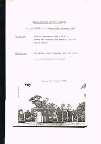
Document - GERMAN HERITAGE SOCIETY COLLECTION: TATURA DISTRICT 1939-1947, Sunday 14th November 1993
Compiled reference articles on the Tatura District, 1939-1947. Information from War Museum Archives, Canberra. File 780/1 (2 pages). Tatura and the Shire of Rodney, by W H Bossence. Walls of Wire, Tatura Rushworth Murchison by Joyce Hammond. The Story of the Beilharz Family by Dr. Paul Sauer. Contains a map, with Internment Camps, of the Shire of Rodney, Prisoners of War in Australia During World War 2, Special Requirements for Internees : Accommodation. Chap. 1, Prisoner of War and Internment Camps at Tatura, Vic., Plan of the Camp. Has a pale yellow front cover and a pale blue back cover.document, memo, german heritage society, german heritage society collection - visit to tatura, german heritage society bendigo, german war cemetry, war museum archives canberra, tatura and the shire of rodney, walls of wire tatura rushworth murchison, the story of the beilharz family, ian walder, geoff pedersen, kurt beilharz -
 Bendigo Historical Society Inc.
Document - GERMAN HERITAGE SOCIETY COLLECTION: BUILDINGS, MINES & PLACES
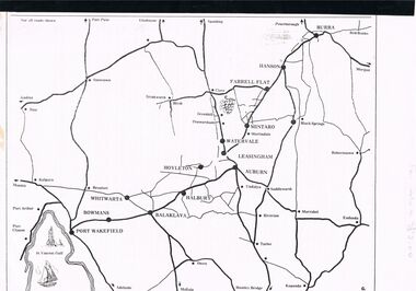
Collection of Articles with a map of part of South Australia north of Adelaide. Contains articles and photos about Tailem Bend, Murray Bridge, Kapunda, Burra, Clare, Penwortham, Sevenhill, Eudunda, Mintaro, Watervale, The House of Quelltaler, Leasingham and Auburn. It also contains a story by Gaye Sprenglewski.societies, service clubs, german heritage society, german heritage society collection - colllection of articles about buildings, mines & places, tailem bend, murray bridge, kapunda, burra, clare, penwortham, sevenhill, eudunda, mintaro, watervale, the house of quelltaler, leasingham, auburn, gaye sprenglewski. -
 Bendigo Historical Society Inc.
Slide - DIGGERS & MINING: THE DIGGINGS - THE DIGGERS
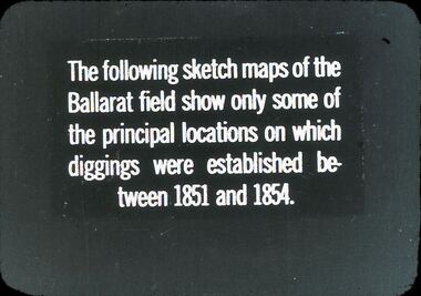
Diggers & Mining: The Digging - The Diggers. Slide reads: The following sketch maps of the Ballarat field show only some of the principal locations on which diggings were established between 1851 and 1854. Markings: 9 994.LIF:6. Used as a teaching aid.hanimounteducation, tertiary, goldfields -
 Bendigo Historical Society Inc.
Document - GERMAN HERITAGE SOCIETY COLLECTION: MAPS OF GERMANY
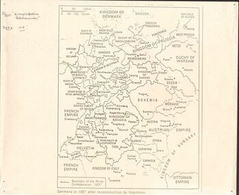
... Bendigo Historical Society Inc. Bendigo Historical Society ...Item 21. Maps of Germany. Germany in 1807 after reconstruction by Napoleon, Germany, Map of Germany States with their Coat of Arms, Thirty Years War Map 21b,Europe in the Time of Henry VIII, Europe in The Time of James I and Charles I, Europe at the End of the 15th Century, Boundaries before 1918 showing Kingdoms, Duchies, provinces, etc., of the Former German Empire (2 copies), Two Grosser Plan Vor Hamburg. Photocopies of Der Rodingsmarkt Hamburg, Kehrwieder Hamburg and Rathhausmarkt und Borse Hamburg. Photocopy of Silesia's Place in History,document, certificate, map of germany, german heritage society collection - maps of germany, theodor w brandt's verlag -
 Bendigo Historical Society Inc.
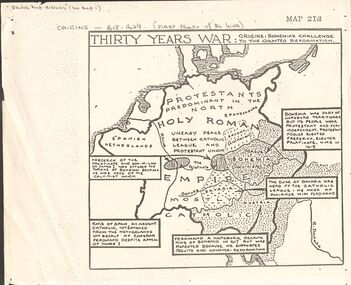
Document - GERMAN HERITAGE SOCIETY COLLECTION: MAPS OF GERMANY (PERIODS OF CHANGE)
... Bendigo Historical Society Inc. Bendigo Historical Society ...Item 21. Maps of Germany (Periods of Change) held in two buff coloured commerce folders. Name written on the front in purple. Three loose copies of the Thirty Years War Map 21a, 21c and 21d. Maps of the Thirty Years War,Europe at the End of the 15th Century, The Reformation in Europe (16th Century), /Europe in the Time of Charles II & James II, The Domination of France 1660 - 85, Europe in the Time of Henry VIII, Germany in 1807 after reconstruction by Napoleon, German Federation 1815, The German Federation 1815, The German Empire of 1871, The Growth of the German Zollverein, Boundaries Before 1918 showing Kingdoms, Duchies, Provinces, etc., of the Former German Empire, the German Empire (1871 - 1918), and Boundaries before 1918 showing Kingdoms, Duchies, Provinces, etc., of the Former German Empire. The last page has a small map of Europe, a small map showing East and West Berlin, German Coats of Arms, Comparative International Figures of Population and a short article titled 'Do You Know Germany'.document, certificate, maps of germany, german heritage society collection - maps of germany (periods of change) -
 Bendigo Historical Society Inc.
Medal - GOLDEN SQUARE P.S. LAUREL ST. 1189 COLLECTION: CENTENARY OF FEDERATION MEDALLION
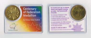
Eleven Centenary of Federation Medallions - For Primary School Students. The medallion is gold coloured with: Australia It's What We Make It and six people moving objects on one side and a rough sketch map of Australia 1901 - 2001 and 'One Hundred Years of Federation' on the other. The end of the line drawing of Australia has a star on it. The back of the card has a brief history and the front has a rainbow colour and the title and dates.Medallion designed by John Skillington and produced buy the Royal Australian Mint.education, primary, golden square laurel st p.s., golden square primary school 1189 collection - centenary of federation medallion - for primary school students, john skillington, royal australian mint -
 Bendigo Historical Society Inc.
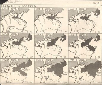
Map - GERMAN HERITAGE SOCIETY COLLECTION: GROWTH OF PRUSSIA
... Inc. History House 11 Mackenzie Street Bendigo goldfields MAP ...Photocopy of a map titled Growth of Prussia. Nine maps with the dates 1415, 1524, 1618, 1648, 1720, 1744, 1772, 1793 and 1795. Maps have letters (a) to (i) as well.map, german heritage society collection - growth of prussia-map 38 -
 Bendigo Historical Society Inc.
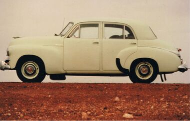
Photograph - PETER ELLIS COLLECTION: HOLDEN CAR
Coloured photograph. Old Holden car. Rocky hill. Back of photo reads: Between Coober Pedy and Marla on route to Alice Springs National Folk Festival Easter 1987. (then in different writing) This car, FJ Holden (1954-1956) was Peter Ellis's, previously used by Doc Robbins to map the Whipstick before Peter bought it.photo, individual, peter ellis car -
 Bendigo Historical Society Inc.
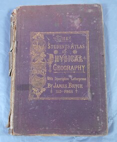
Book - Atlas of Physical Geography
The student's atlas of physical geography consisting of twenty maps, constructed and engraved by Edward Weller F.R.G.S. with descriptive letterpress by James Bryce L.L.D F.R.G.S. Published by William Collins, Sons & Company, London, Glasgow and Edinburgh 1871. Brown cover with the title of the book in gold letters. to the left of the title, also in gold, three circles with different pictures inside. the first of two boats on the sea, a volcanic eruption and a mountain peak.On first page in pencil the name Carrie Van Damme.geography, atlas, 1871 -
Bendigo Historical Society Inc.
Booklet - The Bendigo Naturalist
The Bendigo Naturalist (a set of 5). The Journal of the Bendigo Field Naturalist Club. Vol 5 Nos. 1&2, Vol 6 Nos. 1&2, Vo; 7 No. 2 Each booklet illustrated with B&W photos and maps. Featuring articles and reports on flora and fauna subjects of the Bendigo Area. bendigo naturalist, widlife, flora & fauna -
Bendigo Historical Society Inc.
Booklet - The Eppalock Catchment
Yellow covered booklet of 36 typed and copied pages entitled 'Project for Environmental Education Resources Development. THE EPPALOCK CATCHMENT Sub-Catchment What's Up the Creek? A Resource for Teachers. Includes a diagram of the Water Cycle, 2 maps of the Pohlman's Creek Catchment and Soil Studies. Also includes Pre-Excursion, Excursion and Post- Excursion Activities as well as Record Sheets for Excursions. The name 'Dr W.N.Holsworth' is stamped on the front cover and the date 29 April 1981lake eppalock, catchment study, teachers' resource -
Bendigo Historical Society Inc.
Booklet - Burrow, Burra and 'Borough - a Powell Family History, 1996
Spiral bound pale coloured plastic cover booklet of 82 pages 'Burrow, Burra and 'Borough' a Powell Family History. B&W photo of Powell people on front cover. Compiled and edited by Pauline E Powell 1996 Illustrated with B&W photos and mapsHandwritten comments made against some photspowell, family history -
 Bendigo Historical Society Inc.
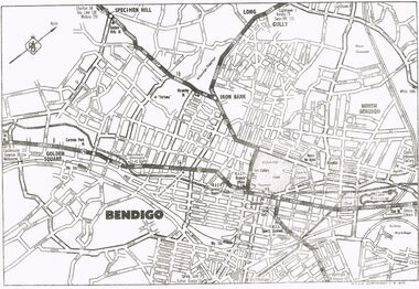
Map - MAP OF CENTRAL BENDIGO
... MAP OF CENTRAL BENDIGO...Map of Central Bendigo, RACV Copyright (no date... Inc. History House 11 Mackenzie Street Bendigo goldfields MAP ...Map of Central Bendigo, RACV Copyright (no date - but RACV Branch Office is shown as being at View Point). Black & White Copy. Showing road and rail system and prominent features of City landscape.RACV Copyright.map, bendigo, city streets, long gully, north bendigo, golden sqyare, specimen hill, iron bark. -
 Bendigo Historical Society Inc.
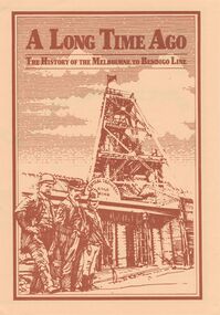
Document - A LONG TIME AGO: THE HISTORY OF THE MELBOURNE TO BENDIGO LINE
'A LONG TIME AGO: THE HISTORY OF THE MELBOURNE TO BENDIGO LINE' Bi-fold publication. A schematic 'strip' map of the line with particular places (approx 40) marked on the route with short descriptions of these sites. Concise description of the construction of the line; a summary of present attractions for the visitor to Bendigo and V/Line information.Walker Printing Bendigorailways, bendigo to melbourne, brochure, barkers creek , harcourt, elphinstone tunnel, malsmbury, malmsbury viaduct, kyneton, carlsruhe, hanging rock, woodend, mount macedon, riddells creek, clarkefield hotel, rupertswood, sunbury, diggers rest, sydenham, st albans, spencer street. v/line. -
 Bendigo Historical Society Inc.
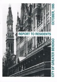
Book - BOOKLET: ''REPORT TO RESIDENTS CITY OF GREATER BENDIGO, OCTOBER 1995''
Front cover is a photo of The Shamrock Hotel. 52 paged booklet - ''Report to Residents - City of Greater Bendigo, October 1995''. Table of Contents; Commissioners; Chief Executive Officer; Council meetings; Office location and hours; ''One Telephone Number''; Committees; Ward boundaries; Elections; Customer services; Rural services; Economic development; Bendigo Tourism Board; Bendigo Trust; Events Bendigo; Capital works 1995/96; Major projects; Discovery; Bendigo Regional Arts Centre; local laws; Fire prevention; Aged and disability services; Children and family services; Environmental health; Recreation and leisure; Parks and gardens; Planning and building; Waste management; Library services; Bendigo Leisureland; Rates; Budget for 1995/96; Index. Contains some photographs and map of proposed 7 internal Wards for the City of Greater Bendigo.Richard Cambridge Printers Bendigo.bendigo, council, report, maxine crouch, maurie sharkey, perer ross-edwards, peter seamer, hadley sides, richard morriss, bernard smith, annie galvin child care centre, bendigo regional art centre, rosalind park, budget 1995/96. bendigo health care services. -
 Bendigo Historical Society Inc.
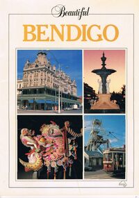
Book - PICTURES AND ATTRACTIONS OF BENDIGO: BEAUTIFUL BENDIGO
... Map of Bendigo.... Joss House Bendigo's Sun Loong Dragon. Sandhurst Town Map ...Booklet (18 pages) ''Beautiful Bendigo'' - coloured pictures of Bendigo and attractions with one page foreword. Published in association with the Bendigo and District Tourism Association, 1987. Includes city map at back of booklet.Printed in Singapore by Toppan Printing Company. Published by Robert Brown & Associated (Aust) Pty Ltd.bendigo, tourism, guide, tramways, george lansell, gold mines hotel, specimen cottage, queen elizabeth oval, secred heart cathedral, camp hill primary school, public library, conservatory gardens, school of mines. central deborah mine. dai gum san wax museum, kwan gung joss house, bendigo's sun loong dragon. sandhurst town, map of bendigo. -
 Bendigo Historical Society Inc.
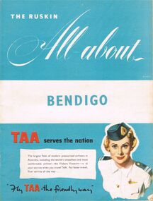
Book - BOOKLET: THE RUSKIN ALL-ABOUT
40 paged booklet - ''The Ruskin All-about'' (covering the Municipality of Bendigo facilities and activities), printed by The Ruskin Press, 1955. ''assisted by the Municipal Council and its officers and office-bearers of other organizations and associations''. Contents: Abbreviations; Baby Health Centres; Bus services; By-laws and regulations; Churches; Classified advertisers; Community activities; Doctors and surgery hours; Facts on the city; Friendly Societies; Hospitals; Magazine section; Maps; Message from the Mayor; Miscellaneous; Municipal services; The Municipality; Public and semi-public utilities; Schools and kindergartens; Sporting and recreation. Information on the forthcoming Olympic Games.Ruskin Publishing Pty. Ltd., 37 Swanston Street Melbourne.bendigo, tourism, guide -
 Bendigo Historical Society Inc.
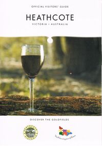
Book - HEATHCOTE: OFFICIAL VISITORS' GUIDE
Heathcote - Official Visitors' Guide. 18 page coloured booklet published by Heathcote Tourism and Development Inc. 2005. Attractions and activities in Heathcote area; accommodation options; dining. Includes map of township and nearby.Bart n Printvictoria, history, regional history., heathcote visitors guide