Showing 2047 items
matching building and construction
-
 Otway Districts Historical Society
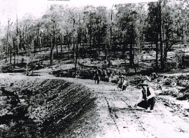
Photograph, Knox Collection, Surveying construction near Barongarook, 1900, 1900
In 1898 a recommendation for a railway of 2 ft 6 in gauge was handed down by the Parliamentary Standing Committee on Railways, to cost $138,000. Construction of the Colac-Beech Forest railway line began in 1900. About 100 men were employed in laying and ballasting the track while others formed the earthworks and the building of culverts and bridges. The earthworks of gravel ballast 150 mm deep were formed by horse and scoop or by shovel. Once the bed had been laid surveyors went along to check the layout, particularly all check rail curves and all 100 metre curves which the surveyors in the picture are doing.B/W. Three men surveying the construction of a curved bed on which track will be laid, near Barongarook, Victoria.colac; beech forest; barongarook; railways; -
 Old Gippstown
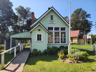
Building - School, c.1888
2903 SUNNY CREEK formerly YARRAGON EAST. Sunny Creek State School, first called Yarragon East, was situated on Sunny Creek Road between Yarragon and Trafalgar and was opened in 1888. It was generally served by two teachers or a Head Teacher assisted by a Sewing Mistress. Edwin Mann taught there for 35 years, with his wife, Mrs Mann, as the Sewing Mistress for some years. [Extracted from Vision and Realisation: A Centenary History of State Education in Victoria, Vol. 3, 1973. This does not contain any details of the actual construction of the school, which is a typical Education Department building, and may date from later than 1888]High local historic significance, with some social significance: reunions of old students still held. (Dr Linda Young, Deakin University, significance assessment July 2009)Single-classroom State School. It is a rectangular-shaped timber building with weatherboard walls, timber frame and corrugated iron roof. An outside verandah is situated along the side of the building. Inside there is a small entry porch, a blackboard the length of the room (with fireplace) and a small store-room/cloak room. Built in 1888Has a name broad above the front window that reads " SUNNY CREEK SCHOOL SS2903" ON IT.school, sunny creek, old gippstown, west gippsland, gippsland, gippsland heritage park, city of latrobe council, goldfields, coal mines, victorian era, moe, historical village, education, sunny creek road, baw baw shire, yarragon east, broad of education., latrobe valley, old gippsland heritage park -
 Ballarat Tramway Museum
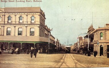
Postcard, John Phillips and Rose Stereograph Co, Bridge St (Looking East), Ballarat, c1905
Image is an ESCo tram leaving the intersection of Grenville St. and Bridge St. and proceeding east along Bridge St. Photo taken behind junction points. Has the Nicholl & Allan building on the left side of the photo and the Bucks Head Hotel on the right. Numerous people walking around the street. Shows overhead construction in the area. Title in top left-hand corner "Bridge St. (Looking East), Ballarat. On the rear is places for stamp, address and manufacturer's name in a fancy motif "WTP". Photo taken soon after opening, no roof-mounted destination boxes. See item 9010 for a printed version. yields information of Bridge St at Grenville St, c1905B&W print, laser print and scanned images of a coloured postcard lent to the BTM by Mr. Norm DePomeroy, August 1998 and Sovereign Hill reproduction of this card contained within a scrap book. See Notes for various image holdings and history.trams, tramways, esco, sturt st, postcards, bridge st., grenville st -
 The Beechworth Burke Museum
Photograph, Unknown c.1930s
This image shows Bethanga Bridge, which was constructed between 1927 and 1930 in Albury, NSW. The bridge was a necessity due to the building of the Hume Dam (Wier), 1919-1936. Bethanga Bridge is a long, nine-span, riveted-steel, variable depth, Pratt Truss road bridge of nine principal spans of 82 metres and a total length of 752 metres over the flooded valley of the Murray River, now part of Hume Reservoir. Because of its unique location, over the waters of a dam with the border running down the centre of the body of water, the Bethanga bridge is the only built structure shared by both New South Wales and Victoria. It was built 1.6 kilometres upstream of the dam and in 1961 was raised 300mm, with a concrete deck replacing the original wooden deck. The State Rivers and Water Supply Commission of Victoria and the New South Wales Department of Public Works were responsible for the construction works for the Hume Weir under the River Murray Waters Agreement. It is apparent that a similar joint arrangement was made for the construction of the Bethanga Bridge as part of the Hume Weir works.This photograph of the Bethanga Bridge is of historical significance as it showcases the architectural skills of Percy Allen and Vincent Packer. Additionally, it reveals the environmental landscape of the 1920s-1930s, is linked to the Hume Dam and both New South Wales and Victorian heritage. Unmounted black and white rectangular photograph. Reverse: 1997.3196 84-20-3bethanga, bethanga bridge, hume dam, pratt truss, murray river, hume weir, transportation -
 Wodonga & District Historical Society Inc
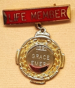
Badge - Life Member Wodonga Swimming Pool Committee - Grace Emery, 1991
Mrs Barbara Emery, born in Beechworth in 1914 was one of the original members of the Wodonga community who formed a Committee and lobbied for the building of a swimming pool in Wodonga. This was prompted after many near misses and a drowning at the popular swimming spot in Wodonga Creek. She and her husband Bob, along with other Committee members lobbied the Wodonga Council and were finally able to negotiate land which fronted onto Stanley Street, Wodonga. Members of the Committee worked tirelessly to fund raise and also to build the pool itself. Countless working bees were organised to complete the construction and surrounds. The pool opened on 12th December 1959. Mr Bob Emery became the manager and Grace ran the kiosk for many years. Later reflecting on her life in the Wodonga community Mrs Emery stated, “To get the pool was a highlight in my life, the satisfaction that we could save lives.” After years of heated discussion about the future of the Stanley Street pool and the construction of a new pool, it finally closed on 31 March 2012. Mrs Emery died in Wodonga.This membership badge is significant because it was awarded to a member of the Wodonga community to recognise her service.A gold plated and enamelled badge attached to a red enamelled bar. The badge is engraved on the front.On bar;- LIFE MEMBER On badge; 1991 GRACE EMERYgrace emery, wodonga swimming pool, life membership grace emery -
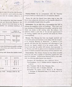 Bendigo Historical Society Inc.
Document - PETER ELLIS COLLECTION: LETTER
Photocopies of some pages mentioning the Museum. Part of a letter by P H MacGillivray, President, Report on the Botany Class, Report on the Chemistry and Metallurgy Classes, The Museum, including what exhibits, attendance of visitors and opening times. A number of pages of Donations to the Museum from 1/7 1891 to 30/6/1892, including the names and address of the donors. There is a list of the Classification of Specimens (received during the year). Also mentioned is Botany - Lecturer - J B Lillie Mackay and Zoology - Lecturer - J B Lillie Mackay. There is also a part of the printing about Architectural and Geometrical Drawing, Machine and Building Construction - Teacher - W H E Nicolai.museums, peter ellis collection, bendigo school of mines, dr macgillivray, rev j garlick, dr colquhoun, mr g alec thomson, mr j eardsley edwards, dr quick, j m harcourt, j robshaw, r bloomfield rees, j d crofts, w h carwardine, dr dendy, professor marshall hall, professor baldwin spencer, department of education, sir frederick mccoy, baron von mueller, j w faul, john robshaw, henry jackson, j b lillie mackay, melbourne university, mr a south, department of forestry, mr perrin, the pharmacy board of victoria, education department -
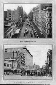 Melbourne Tram Museum
Photograph - Black & White Photograph/s, Tramway Museum Society of Victoria (TMSV), c1975
Black & White Photograph of a postcard made by the TMSV Sales consisting of two postcards showing cable trams in Elizabeth St, looking north from the Flinders St clock tower and Bourke St looking east from Swanston St. The first shows a bogie trailer being shunted. The second has the Myer store in the view. The first photo is dated between 1933 and 1935 based on the construction of the building next door to Hosies in 1933 and the closure of the cable lines in 1935. See 7-9 Elizabeth St - see https://s3.ap-southeast-2.amazonaws.com/hdp.au.prod.app.com-participate.files/8215/9494/3548/PROPERTY_103166_7TO9_ELIZABETH_ST.pdf - accessed 7-5-2022Has "TMSV 332 Flinders St Melbourne 3000" stamp on the rear.trams, tramways, cable trams, shunting, elizabeth st, bourke st, bogie cable trailers -
 Kiewa Valley Historical Society
Four photographs of the Blue Duck Hotel and two Photos of the Glen Wills area, c1920 Post cards, c1949/50 small photographs
The Blue Duck Hotel stands at the confluence of 3 trout rivers - Cobungra, Bundarra and Mitta Mitta, called Angler's Rest. The original 1900's building was of slab construction and operated as a butcher shop, servicing miners on the track from Omeo to Mt. Wills. In 1912 it was purchased by a miner, Billy O'Connell, and he obtained a hotel license. In the early 1920's he transported 2 houses from Omeo on Horse drays. One is the main building of the Blue Duck and the other was a residence where Billy and his wife raised their nine children. The small log structure behind the pub is State School No.4286 where the children attended school. A teacher was shared with Glen Wills. By the late 1920's the hotel was discovered and patronized by keen anglers. Sir Harold Clapp (head of the railways) was one and he had the bronze blue duck cast and presented to the owners in the 1930's. This stands at the entrance to the premises.These photographs are of a building, in a remote area, that has provided a service to miners, anglers and travellers for over 100 years and continues to do so today. It also played a vital role in the history of the Mt. Wills/Omeo gold mining days.3 Post cards, Black and White photographs. 3 small black and white photographsPost Card No. 1 - "Blue Duck Hotel- Omeo-Glen wills road Ray Love Series No.2"(written on lower front) Post Card No. 2- "Looking towards Bogong High Plains. Omeo-Glen Wills road"(front, bottom, L hand) Ray Love Series No. 18 (front, lower R hand corner) On both of above photos, centre back, is stamped POST CARD and underneath this is printed "A GENUINE PHOTOGRAPH'/ Post Card No. 3 - Bottom L hand corner "Mystic Sea Australian Alps". R hand corner "(Bulmer Copyright)". Each small photograph, handwritten on back "Blue duck Hotel". All have circular stamp with "Print by Wilson White Albury" blue duck hotel; anglers rest; omeo highway; fishing; mining -
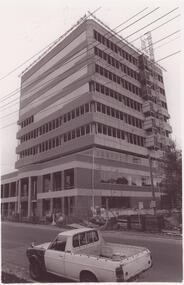 Glen Eira Historical Society
Article - Caulfield Institute of Technology
Four items about the establishment,history and courses provided at this Institute: 1/Research notes (2 pages in all) regarding the renaming of Caulfield Technical School to Caulfield Institute of Technology in 1968 sourced from La Trobe Library Reference Index. Several dates listed. Reference also to article on construction of building in 'Australian Builder' of January 1950. 2/Photocopy of article from 'The Australian Accountant', April 1975. Gives history of C.I.T. and of Business School courses plus photos. (3 pages) 3/Advertising flyer for 'The David Syme Business School at CIT' listing courses for enrolment by 15/12/1978. 4/Undated black and white photograph of building in progress on site of Caulfield Institute/Monash University Caulfield. Noted on reverse'Chisholm Tower', 'Contact June 29, PIC 3 PG3 100% pl2' ie likely taken by photographer for 'Caulfield Contact'.miller j.o. mr. (b.a. b. com. f.a.s.a.), huggan noel, halstead h.j. mr., kurtz david professor, holmes graham, collins mike, chataway graham, erdonmez hassan, gleeson june, voumard lou, coombe jack, caulfield technical college, caulfield technical school, caulfield institute of technology (cit), k.h. boykett building, monash university, dandenong road, caulfield east, victorian education department, school of business, school of applied sciences, school of engineering, school of industrial studies, school of general studies (humanities sociology art and design), technical schools, technical colleges, education, secondary education, mature age students, david syme business school, 'contact' -
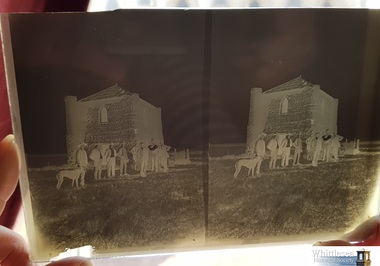 Whittlesea Historical Society Inc.
Photograph - glass plate negative, Bear's Castle, c.1910
Bear's Castle was constructed in Yan Yean circa 1846 probably by two men, Hannaford and Edwards, who had recently arrived separately from Devon, England. It was built for John Bear an early pastoralist who had migrated from England with his family in 1841. Bear's Lookout (or Bear's Folly as it is also known), is a small, two storey structure roughly square in plan and occupying an area of less than 12 square metres. It is built of mud/clay - a common primitive building material apparently used extensively in the Whittlesea area and utilises a technique known as cob, popular in the builders' home town of Devon. Cob is a walling construction method using clay, straw, gravel and sand. The building was constructed to resemble a castle the result, it would seem, of a cursory remark by John Bear with a pyramid shaped roof and turrets at each corner - one with a stair and another in brick and stone with a chimney. Despite its name, it would appear that the building was never used as a retreat from danger although it might well have been used as a lookout for the monitoring of livestock or forest fires.The negative depicts Bear's Castle which is historically significant because of its early, pre- gold rush construction date and its association with notable pioneering pastoralists, the Bear family. The Bears were responsible for establishing one of Victoria's earliest wineries (at Yan Yean) and are associated with Chateau Tahbilk, reputedly Victoria's oldest extant winery.Rectangular glass plate negative showing eight men and a dog standing in front of Bear's Castle at Yan Yeanglass plate negative, bears castle, yan yean -
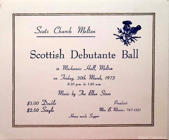 Melton City Libraries
Card, Scottish Debutante Ball invite, 1973
"The Mechanics’ Institute hall (demolished) and the library played a central role in the story of Melton social life, and in the development of its learning, culture, entertainment, celebration, commemoration and many community groups. The building on the site today - with the Court House the only remaining early community or public building remaining in High Street - is a tribute to the energy and talents of the very small Melton community over many years. Its substantial size, brick materials, and the evident use of an architect in its design, sets it apart from most other simple weatherboard Mechanics’ Institutes that were built in smaller country towns in Victoria. The financing and upkeep of this building, which was community-owned until 1982, and built on land purchased by the community rather than granted by Government, itself contributed to the coming together of the Melton community in decision making and fundraising. Although the original hall is demolished, the 1983 Melton Community Hall adjacent is partly its successor, demolition of the Institute hall having been predicated on its construction. The surviving brick front portion of the Institute was opened by the Hon. J Murray, Premier of Victoria in 1910". Scottish Debutante Ball hosted by Scots Church Melton at the Mechanics Hallchurches -
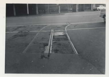 Melbourne Tram Museum
Photograph - Section of cable tram track - Bourke St at Spencer St, c1960
The photograph shows a section of remnant track at the intersection of Bourke and Spencer Sts that remained until it was removed on 25/8/1987 when connecting curves were installed at Bourke and Spencer Streets, forming a double track triangular junction, in preparation for the conversion of the St Kilda and Port Melbourne railway lines to 'light rail'. This necessitated the removal of the last few metres of cable car track in Melbourne, which had been left in situ at the former Bourke Street terminus as a reminder of bygone days. Shows two inspection pits in the short section of the cable slot. Photo late 1960s after the construction of the Spencer St railway station building. Photographer unknown.Yields information of last section of visible cable tram track in the city area.Black and white photograph on Ilford papertramways, cable trams, track work, bourke st, spencer st, cable track -
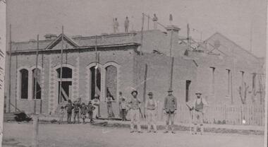 Bacchus Marsh & District Historical Society
Photograph, Mechanics Institute and Hall Main Street, Bacchus Marsh 1883
A Mechanics Institute in Bacchus Marsh dates from sometime in the 1850s. The first Mechanics Institute Hall was erected in 1858 in Young Street.(Victorian Collections no.659.) In 1883 a new and larger Mechanics Institute Hall was built in Main Street. The new hall cost 2,000 pounds to construct. It was opened by Sir William Clarke on 21 November 1883. The Mechanics Institute Library and rooms at the front of the hall were removed when the building was renovated in 1971. The building still stands and is used as a public hall.Small black and white 'carte de viste' style unframed photograph on card with gold border framing photograph. Housed in the Jeremeas Family Album which contains photographs of Bacchus Marsh and District in 1883 by the photographers Stevenson and McNicoll. The photo is of a substantial brick building under construction. Scaffolding support poles line the front and also can be seen on the top and back of the building. On the rooftop stand three workmen, with a further seven men standing at the front. Three men lean or stand casually at the front in casual poses. Four men stand in a line in another group on the roadway, perhaps indicating that they are master craftsmen. One of these men holds a tool of his trade, resembling a bricklayer’s mortar board. Six boys can be seen, four in a rather jaunty pose. In an indication of its public significance, the four front windows and door are arched and have decorative stone work in the side panels. A picket fence marks the boundary of the adjacent block.Printed On the front: Stevenson & McNicoll. Photo. 108 Elizabeth St. Melbourne. COPIES CAN BE OBTAINED AT ANY TIME. On the back: LIGHT & TRUTH inscribed on a banner surmounted by a representation of the rising sun. Copies of this Portrait can be had at any time by sending the Name and Post Office Money Order or Stamps for the amount of order to STEVENSON & McNICOLL LATE BENSON & STEVENSON, Photographers. 108 Elizabeth Street, MELBOURNE. stevenson and mcnicoll 1883 photographs of bacchus marsh and district, mechanics institutes, halls, bacchus marsh mechanics institute -
 Federation University Historical Collection
Register of Attendances, Ballarat School of Mines Register of Attendances, 1983, 1983
The register lists names and attendances of trade classes at the Ballarat School of Mines.Light blue hard cover with green taped spine Education Department Victoria Technical Schools Register of attendances for the year 1983 in the subject of Building and Construction. Names in the register include Gary Cain, Peter Corrie, Rick Atkinson, David Boadle, Don Hines, Peter O'Donnell, Annette Earles, Albert Stone, Charles Britten, Shane Brereton, Paul Harris, Annette Barby, Raymond Dalton The following students are some listed under Hobby Woodwork classes - Frank Berry, Bev Cochrane, Simon Cochrane, Margaret Copeland, Kath Dean, Margaret Knowles, Elizabeth Munt, Des Shortal, Marj Wilkenson, Val Hibberd, Pat Colquhoun. Record closed. -
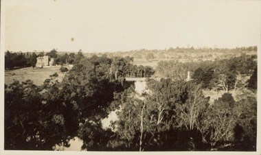 Kew Historical Society Inc
Photograph - Victorian Canoe Club, V.C.C. site, Studley Park, 1920-30
Canoeing on the River Yarra at Melbourne was an important and widespread recreational pursuit for Melbournians, especially in the first half of the twentieth century. The Victorian Canoe Club was formed in 1912 at a meeting in Melbourne and its first committee elected in the same year. Records indicate that the Club continued into at least the 1950s .The album has historic and social significance as a record of recreational activities (as well as canoe making) in the early years of the twentieth century. It has local significance as the site of the headquarters of the Club was in Studley Park. A number of photographs in the album provide vistas of Kew on the Yarra that are otherwise unavailable.One of 24 labelled photos in part album, originating from the Victorian Canoe Club, which had its headquarters in Studley Park, Kew. The album includes a photographic record of canoe construction and also locations in Studley Park and Kew where the canoes were used. The subject of this photograph is identified as 'V.C.C. site, Studley Park'.The panoramic view shows a number of important landmarks during this period. On the left of the photograph is one of the remaining buildings of the Yarra Bend Asylum. Stretching across the river is a suspension bridge on the site of the present Kane's Bridge. The reference to the V.C.C. site is unclear within the context of the photo which appears to be taken from the vicinity of the Johnston Street Bridge."V.C.C. site, Studley Park"victorian canoe club, river yarra, canoe clubs, yarra bend asylum, suspension bridge -- kew, kane's bridge, studley park -
 Melbourne Tram Museum
Document - Radio Transcript, Melbourne & Metropolitan Tramways Board (MMTB), "Wireless Talk -- Mr. J. D. Barton Staff Officer MMTB - Melbourne Street Transport No. 2", late 1920's
Radio Transcript or script, 7 foolscap typed pages, double spaced titled "Wireless Talk -- Mr. J. D. Barton Staff Officer MMTB - Melbourne Street Transport No. 2". Report looks at the history of horse bus routes in Melbourne, building of the cable trams, the Parliamentary Bills for the cable trams, constructing the lines, Mr. G. Duncan, Mr. Clapp, construction difficulties, the Melbourne Tramway Trust, MTOC, drainage issues, bridges, alterations to the Act, Patent issues with a London company, opening dates and comments about wire rope. Could be a few pages missing given the way it ends, no thank you or formal ending. Item noted dated, presumed late 1920's.Has pencil notation in top left hand corner "6 copies"trams, tramways, public transport, radio stations, horse buses, mto co, melbourne, cable trams, mtt -
 The Beechworth Burke Museum
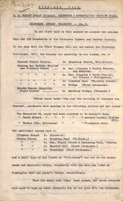
Photograph, c. 1900
This black and white photograph shows the front view of the Ovens Benevolent Home with one person sitting on a bench seat against the nearest part of the building and another person walking on the grass. This photo is estimated to have been taken in the early 1900’s when the Ovens Benevolent home would have still been fairly contemporary. According to Woods (p. 121) in the 1860’s the government spent considerable sums to establish several public buildings such as the Benevolent Asylum, the Hospital and Insane Asylum to support those in need of care in the area directly after the Indigo gold rush which had left Beechworth, a fairly remote regional and newly formed township (Gold was first discovered in Beechworth in 1852) with a number of infirm and destitute people in its wake and which due to the support and establishment of these facilities ‘made Beechworth a significant social welfare centre in Victoria’ (Woods, p. 121). Originally named the Benevolent Asylum, the building was renamed as The Ovens Benevolent Asylum in 1935 and again to The Ovens and Murray Home in 1954. The building construction began in 1862 and was unique in its features of Flemish Gothic Revival style which utilised red brick and granite, ‘the main facade is dominated by four curved, Flemish gable ends, […] incorporates paired windows of pointed Gothic form and dark brick diaperwork patterning. The adjacent J. A. Wallace Wing of 1899 was designed by Donald Fiddes as a separate building. Also constructed of red brick, Fiddes adopted a conservative approach, designing a simple domestic scale building with central projecting gable porch and flanking bull nosed verandahs.’ (https://vhd.heritagecouncil.vic.gov.au/places/118). Initially established to provide housing and care for aged, orphaned or widowed members of the population, over time the Ovens Benevolent Home focused more on the age care responsibility which functioned as such up until 2005.The Ovens Benevolent Home is significance due to its association with the early development of Beechworth. It shows the civic, social welfare development that took place in the town after the peak of the gold rush which helps to establish the character of the community being built at the time and their cultural values at play. This photograph also clearly shows the early functioning landscape of that building and its purpose as well as the significant elements of its aesthetic significance and unique and striking architectural forms of the building.Black and white rectangular photograph [copy from slide]Reverse: / 7588 /housing and care, aged care, donald fiddes, ovens benevolent home, flemish gable, brick diaperwork, photograph, black and white photograph, public building, benevolent asylum, indigo gold rush, beechworth, the ovens and murray home -
 Kew Historical Society Inc
Plan, Borough of Kew Detail Plan No.1577, 1904
The Melbourne and Metropolitan Board of Works (MMBW) plans were produced from the 1890s to the 1950s. They were crucial to the design and development of Melbourne's sewerage and drainage system. The plans, at a scale of 40 feet to 1 inch (1:480), provide a detailed historical record of Melbourne streetscapes and environmental features. Each plan covers one or two street blocks (roughly six streets), showing details of buildings, including garden layouts and ownership boundaries, and features such as laneways, drains, bridges, parks, municipal boundaries and other prominent landmarks as they existed at the time each plan was produced. (Source: State Library of Victoria)This plan forms part of a large group of MMBW plans and maps that was donated to the Society by the Mr Poulter, City Engineer of the City of Kew in 1989. Within this collection, thirty-five hand-coloured plans, backed with linen, are of statewide significance as they include annotations that provide details of construction materials used in buildings in the first decade of the 20th century as well as additional information about land ownership and usage. The copies in the Public Record Office Victoria and the State Library of Victoria are monochrome versions which do not denote building materials so that the maps in this collection are invaluable and unique tools for researchers and heritage consultants. A number of the plans are not held in the collection of the State Library of Victoria so they have the additional attribute of rarity.Original survey plan, issued by the MMBW to a contractor with responsibility for constructing sewers in the area identified on the plan within the Borough of Kew. The plan was at some stage hand-coloured, possibly by the contractor, but more likely by officers working in the Engineering Department of the Borough and later Town, then City of Kew. The hand-coloured sections of buildings on the plan were used to denote masonry or brick constructions (pink), weatherboard constructions (yellow), and public buildings (grey). MMBW Plan No.1577 includes some of the most significant houses in Kew: Herbert Henty’s ‘Roxeth’ (now part of Trinity Grammar), ‘Butleigh Wooton’, ‘Bokara’ and ‘Harrow’. It also includes the streets that have since changed their names. That part of College Parade linked to Glenferrie Road is now named College Place, College Parade now extends further north, and Charles Street did not yet reach Barkers Road. Roxeth is one of a number of Henty houses in Kew. Herbert Henty made his home here and was elected a member of Kew Municipal Council in 1864 and mayor in 1868-69. Walter Henry Serle, of Harrow served in the First World War. He was awarded the Military Medal ‘’For conspicuous bravery and devotion to duty. On 29th September near BELLICOURT he showed the greatest bravery and determination when his platoon was attacked by enemy bombing parties. It was due largely to his personal efforts that all the attacks were repulsed. Until wounded, his utter disregard of personal safety and boldness in dealing with the attacks were the means of saving the situation and were an inspiring example to his men.’melbourne and metropolitan board of works, detail plans, maps - borough of kew, mmbw 1577, cartography -
 Kew Historical Society Inc
Plan, Melbourne & Metropolitan Board of Works : Borough of Kew : Detail Plan No.1588, 1904
The Melbourne and Metropolitan Board of Works (MMBW) plans were produced from the 1890s to the 1950s. They were crucial to the design and development of Melbourne's sewerage and drainage system. The plans, at a scale of 40 feet to 1 inch (1:480), provide a detailed historical record of Melbourne streetscapes and environmental features. Each plan covers one or two street blocks (roughly six streets), showing details of buildings, including garden layouts and ownership boundaries, and features such as laneways, drains, bridges, parks, municipal boundaries and other prominent landmarks as they existed at the time each plan was produced. (Source: State Library of Victoria)This plan forms part of a large group of MMBW plans and maps that was donated to the Society by the Mr Poulter, City Engineer of the City of Kew in 1989. Within this collection, thirty-five hand-coloured plans, backed with linen, are of statewide significance as they include annotations that provide details of construction materials used in buildings in the first decade of the 20th century as well as additional information about land ownership and usage. The copies in the Public Record Office Victoria and the State Library of Victoria are monochrome versions which do not denote building materials so that the maps in this collection are invaluable and unique tools for researchers and heritage consultants. A number of the plans are not held in the collection of the State Library of Victoria so they have the additional attribute of rarity.Original survey plan, issued by the MMBW to a contractor with responsibility for constructing sewers in the area identified on the plan within the Borough of Kew. The plan was at some stage hand-coloured, possibly by the contractor, but more likely by officers working in the Engineering Department of the Borough and later Town, then City of Kew. The hand-coloured sections of buildings on the plan were used to denote masonry or brick constructions (pink), weatherboard constructions (yellow), and public buildings (grey). This plan shows the original configuration of the Kew Post Office, Court House and Police Station, which had opened in 1888. This configuration was to essentially remain until the purchase of the Court House and Police Station by the City of Boroondara in 2007 and its subsequent renovation. Interestingly, the MMBW surveyors incorrectly labelled parts of the complex. In the triangle in front of the Post Office, before the erection of the Kew Cenotaph in 1925, was located a lawn and the Queen Victoria Jubilee Fountain. While many of the shops on the south side of High street had been constructed by 1903 a number of sites were still used as vegetable gardens. Further along High Street, on the corner of Charles Street, the Salvation Army Barracks can be seen on the plan. These Barracks predate the later Citadel and ‘Young People’s Hall’ that were opened in 1919. At 22 Charles Street can be seen the house of James Venn Morgan. Hailed as the ‘father of Kew’, Morgan arrived in Melbourne in 1840. He was first engaged as a bookmaker, but a fortunate venture on the goldfields enabled him to purchase land in Kew. He conducted a market garden and dairy in Kew for many years.melbourne and metropolitan board of works, detail plans, maps - borough of kew, mmbw 1588, cartography -
 Kew Historical Society Inc
Plan, Melbourne & Metropolitan Board of Works : Borough of Kew : Detail Plan No.1591, 1905
The Melbourne and Metropolitan Board of Works (MMBW) plans were produced from the 1890s to the 1950s. They were crucial to the design and development of Melbourne's sewerage and drainage system. The plans, at a scale of 40 feet to 1 inch (1:480), provide a detailed historical record of Melbourne streetscapes and environmental features. Each plan covers one or two street blocks (roughly six streets), showing details of buildings, including garden layouts and ownership boundaries, and features such as laneways, drains, bridges, parks, municipal boundaries and other prominent landmarks as they existed at the time each plan was produced. (Source: State Library of Victoria)This plan forms part of a large group of MMBW plans and maps that was donated to the Society by the Mr Poulter, City Engineer of the City of Kew in 1989. Within this collection, thirty-five hand-coloured plans, backed with linen, are of statewide significance as they include annotations that provide details of construction materials used in buildings in the first decade of the 20th century as well as additional information about land ownership and usage. The copies in the Public Record Office Victoria and the State Library of Victoria are monochrome versions which do not denote building materials so that the maps in this collection are invaluable and unique tools for researchers and heritage consultants. A number of the plans are not held in the collection of the State Library of Victoria so they have the additional attribute of rarity.Original survey plan, issued by the MMBW to a contractor with responsibility for constructing sewers in the area identified on the plan within the Borough of Kew. The plan was at some stage hand-coloured, possibly by the contractor, but more likely by officers working in the Engineering Department of the Borough and later Town, then City of Kew. The hand-coloured sections of buildings on the plan were used to denote masonry or brick constructions (pink), weatherboard constructions (yellow), and public buildings (grey). That area of Kew bordered by Cotham Road, Park Hill Road, Ermington Lane (now Ermington Place), and Belmont Avenue contained some of the significant homes owned by Kew pioneers. Chief among these was ‘Park Hill’ on an enormous lot facing Park Hill Road. The Jubilee History of 1910 noted, six years after this plan was drawn, that: ‘Park Hill Road, forming the southern boundary of the cemetery, takes its name from Park Hill, the residence of Mr. Thomas Judd, who has resided there since December, 1852.’ Other named houses on the plan include ‘Ferndale’ facing Cotham Road; ‘Ermington’ adjacent to Judd’s Park Hill, facing Park Hill Road; and ‘Gilden’ and ‘Mont Belmont’ facing Belmont Avenue. Mont Belmont was designed by the architectural firm of Reed, Henderson and Smart for William George Lilley in 1887 and was completed in 1888. Lilley was Mayor of Kew in 1887-88, a Justice of the Peace and a member of the first Board of Guardians of Kew’s St. Hilary’s Church of England.melbourne and metropolitan board of works, detail plans, survey plans - borough of kew, mmbw 1591, cartography -
 Uniting Church Archives - Synod of Victoria
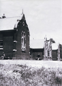
Photograph, undated
The photograph is from the Brian Walsh Collection 1993. Three blocks of land were purchased in 1946 by Miss F. Ritchie and Mrs H. Grimshaw in Halford St. Inverloch. Three more blocks were purchased in 1948 - 1949. A sixth block was added in 1956. Money was raised by P.F.A. members. Two buildings were purchased from the Government Disposals Authority in 1959. Construction of the camp began in October 1959. Regular working bees were held by P.F.A. members. The first camp was held at the site at Easter 1960. The camp was opened by the Moderator the Rt. Rev. A. Creighton Barr and Flinders Presbytery ministers. In 1998 the decision was taken to sell the site. No buyer was recorded by April 2000.Colour photograph mounted on card showing the exteriors of two camp dormitories in bushland.Uniting Church Camp Inverloch. Gippsland Presbytery. Brian Walsh Collection 1993presbyterian church camp, inverloch, flinders presbytery, p.f.a., miss f. ritchie, mrs. h. grimshaw, rt. rev. creighton barr -
 Sunshine and District Historical Society Incorporated
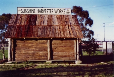
Replica of McKay Smithy, Opened on 10 October 2001
This Smithy is a replica of the building in which the first H. V. McKay harvester was built at Drummartin in northern Victoria in 1884. The original Smithy was moved from Drummartin to Sunshine Victoria where it remained for many years outside the H. V. McKay manufacturing plant. With the construction of the standard gauge railway line the road outside the Smithy was demolished, and the original Smithy was taken to the Melbourne Museum.The original Smithy is now in a fragile state and is no longer on public display at the Melbourne Museum. The site where the original Smithy stood in Sunshine was no longer available so the replica Smithy was erected a few hundred metres away, in the South East corner of Barclay Reserve on King Edward Ave, Albion 3020.The replica Smithy permits the public to view a full sized model of the building which eventually led to the formation of the H. V. McKay Sunshine Harvester Works. This firm grew to being considered the main manufacturing plant in the southern hemisphere, and also led to the local area being renamed in 1907 from Braybrook Junction to Sunshine.Brown wooden building with bark roof. This building is a FULL SIZED REPLICA of the original SMITHY that was used by H. V. McKay.THE SUNSHINE HARVESTER WORKS 1884smithy, h. v. mckay, sunshine harvester works, drummartin, replica, massey harris, massey ferguson -
 Brighton Historical Society
Dress, Day dress, circa early 1900s
This dress belonged to Mary Grace Medbury (nee Matthews, 1885-1967). Mary was born in Kansas, USA, and as a teenager travelled to Devon, England, before she came to Australia with her family and married Walter Ambrose Medbury (1887-1947). They lived together in Cheel Street, East Oakleigh. Walter, a building contractor, worked on numerous construction projects in the Melbourne area, including the Oakleigh Methodist Church, the HMAS Cerberus naval base and - closer to home - the former Brighton Courthouse, which was built in 1936 and still stands at 15 Boxshall Street. Mary gave the dress to her granddaughter, Fiona Nissen, when Fiona was a teenager. A Brighton local, Fiona donated it to the Society in 2013.White cotton muslin day dress with three-quarter length sleeves and square neckline, both edged with lace. The dress features white floral embroidery on the sleeves, skirt and front of bodice. Hook and eye fastenings at back.mary grace medbury, mary grace matthews, fiona nissen, migration, 1900s -
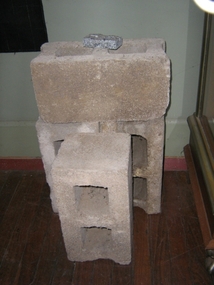 Harcourt Valley Heritage & Tourist Centre
concrete blocks, 1914
Charles Seelenmeyer conducted Concrete Utilities Limited (Harcourt Cement Pipe Factory). Operated in Harcourt circa 1914 to 1930 in premises situated opposite the ANA Hall on what is now the road reserve. Principal raw material was sand from the adjacent waterway ( Barkers Creek.) Principal output was concrete drainage tiles for use in district orchards but concrete blocks were also produced for construction of homes and commercial buildings. At a time of rapid expansion of the orchards this industry provided a vital piece of orchard infrastructure, mostly buried and not now visible but nevertheless a very important feature of the valley’s horticultural industry.. Homes built with these concrete blocks are a distinct part of Harcourt’s housing stock. Harcourt Cement Pipe Co was an example of local initiative to solve a local problem using local materials. A collection of 4 concrete building blocks -
 Wodonga & District Historical Society Inc
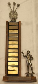
Award - Trophy - Terminus Hotel Wodonga Dart Club, 1985 - 1992
The Terminus Hotel was one of the earliest hotels in Wodonga, with clear links to the establishment of the railway line. It was an important business and meeting place from the original construction in 1873 until 1st June 1998 the Terminus Hotel when it was destroyed by fire. It provided a popular venue for social activities, including competitive darts, both through its own competition and as part of the Albury-Wodonga District Darts Association. The remains of the building were demolished in 1999. This is perpetual trophy for the Terminus Dart club based at the Terminus Hotel in Wodonga. This trophy recognises the winners of the Singles Championship from 1985 to 1992. Engravings on the front of the trophy indicate that the competition was held twice a year for most of the years recorded here.The Terminus Hotel was an important meeting place in Wodonga for more than 100 years. This item is representative of one of the social and sporting activities it provided for members of the local community.A perpetual trophy for the Terminus Dart club based at the Terminus Hotel in Wodonga. This trophy recognises the winners of the Singles Championship from 1985 to 1992. Down the front of the trophy, each name on a separate metal rectangle: 1985: A. Fleming 1985: K.Cook 1986: W. Larsen 1986: J. DeKruif 1987: L. Stokes 1987: J. DeKruiff 1988: J. DeKruiff 1989: C. Shaw 1989: H. Curphy 1991: J. DeKruiff 1992: J. DeKruiff 1992: J. DeKruifterminus hotel wodonga, terminus hotel darts, sport and recreation wodonga, albury-wodonga district darts association -
 Mission to Seafarers Victoria
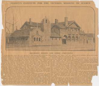
Article, Herald, Seamen's Institute for the Victoria Missions to Seamen, 30 August 1917
SEAMEN'S INSTITUTE FOR THE VICTORIA MISSIONS TO SEAMEN In architectural style, the new Seamen's Institute for the Victorian Missions to Seamen, in Flinders street Extension which is to be opened early in September by Sir Ronald Munro Ferguson, the Governor-General, may be said to resemble the type adopted by the early settlers in California, and known in recent years by the name of Spanish Mission architecture. This character is particularly sympathetic with the object for which the building has been erected, and is exemplified in a marked degree in the unique chapel tower of oblong shape with its four pinnacles and open bell turret, with an almost rustic cross as terminal point: also in the arcaded Eastern Court cloisters, with simple round arch arcading, and in the chapel roof, which is framed of heavy rough-hewn hardwood timber work left as it came from the saw, and erected green from the forest. but so well framed and bolted that no harm can result from shrinkage. The foundations are constructed of reinforced concrete, and in some places are nine feet wide. The ground is very treacherous, and considering the irregular weights of the one story, two-story, and three-story parts of the building, the result achieved in sta bility is eminently satisfactory. The main hall has a vaulted ceiling of reinforced concrete construction, and, spanning 35f., is the widest span of any floor in Melbourne of similar construction. The chaplain's residence is built above the lecture hall, and consists of a most complete, up-to-date dwelling-house of eight rooms. It is fitted with every modern convenience and labor-saving device. The cupboard in the pantry, for instance, has two faces — one in the diningroom and the other in the pantry. Dishes are washed in the pantry, put into the cupboard, and taken out in the diningroom, ready for the next meal. Special rooms are designed for the many and various works carried out for the sailors by the industrious workers of the mission. One room is shelved and fitted for the reception, sorting, and distribution of books, periodicals, and other reading matter that is parcelled up by willing hands and given to sailors as ships leave port, to beguile the weary hours of leisure on the sea. Any old books or magazines, illustrated papers, and the like are always welcome at the insti tute. Reading matter of this kind can easily be saved and sent along in bundles. The gymnasium is not yet built. This is the only part of the building required to complete the block; and when its concrete dome, with open eye at summit like the Pantheon at Rome is erected, the whole effect of the groups of buildings will be most striking. In the entrance hall is a floor of marble mosaic, with a central feature of a mariner's compass seven foot in diameter, well executed by the Adamant Pavement Company, and the gift of Mr George Russell. The architect has designed a copper ship as a finial for the main gable of the building, and it, like the gymnasium, is awaiting the collection of more funds or the generosity of a special donor. The whole of the woodwork of the in terior of the building, including high dados round the walls of halls, stair cases, billiard and other rooms is car ried out in Tasmanian hardwood, fin ished in a dull beeswax polish, and the floors of the entire building, except the lavatories, which are tiled, are also executed in Tasmanian hardwood. Mr Walter R. Butler, F.R.I.B.A., was the architect, and the work was carried out by Mr A. B. Robertson, builder. PICTURESQUE BUILDING AMID SOMBRE SURROUNDINGSThe article gives a valuable description of the Mission at the end of its construction and before its opening.4 columns article with photograph of the front of the Missionlady fraser, walter richmond butler (1864–1949), architecture, spanish mission, california, reinforced concrete, tasmanian hardwood, gymnasium, norla dome, pantheon, adamant pavement company, george russell, compass, finail, weathervane, chaplain's residence, manse, chapel, courtyard, cloisters, main hall, spannig -
 Kiewa Valley Historical Society
Photographs - Demolition of the old Tawonga District General Hospital. Set of 8 colour photographs
In the early stages of the Kiewa Hydro-Electric Scheme the State Electricity Commission took over the financial and construction responsibility of the Tawonga District General Hospital building at a cost of 27,000 pounds. This included the removal and re-erection of the ex-military Bonegilla ward from Wodonga while in addition they carried out all the necessary building works that allowed the hospital to operate as a functional unit. The work was completed and handed over to the Hospital Committee of Management on September 1, 1949. Local residents raised 3,400 pounds through fund raising. The balance was met by the SEC and the Hospital and Charities Commission. The initial project was to provide for a basic temporary hospital which was later to include an Operating Theatre, Offices, Store, Mortuary and a Nurse’s Home, until the establishment of a permanent medical premises. Following the opening, 455 patients were admitted to the Tawonga District General Hospital and 254 operations were performed in the first year. The hospital relocated to Mount Beauty in the former SEC administration offices located in the town centre. Official opening of the 18 bed Tawonga District General Hospital on April 29 in 1961. The old weatherboard building was demolished around the late 1900’s to early 2000’s and replaced with a new modern brick building. Alpine Health CEO Mr Lyndon Seys oversaw the opening of the new Mount Beauty Hospital in November 2001 alongside Board of Management President Mr Andrew Randell, other board members and politicians. The Kiewa Hydro-Electric Scheme the State Electricity Commission played a pivotal part in the planning and initial funding of the Tawonga District General Hospital, with a view to providing medical support for its many workers on the Hydro scheme. Later, spouse and family members of workers were also able to access medical assistance The hospital was originally located in Tawonga away from the majority of the patients as the Hospital and Charities Board was not prepared to have it within the SEC controlled area and it was not until the gate at Tawonga South was taken down that the hospital was moved to the main centre of population at Mount Beauty.8 Colour photographs of the demolition of the original Tawonga and District Hospital situated in Mt Beauty circa 20001. No inscriptions 2. Side view of Tawonga District General Hospital, 1990’s 3. Demolition of the weatherboard hospital: Nurses station, ward and corridor 4. Demolition of the weatherboard hospital: kitchen & utility rooms 5. Demolition of the weatherboard hospital” front entrance & gardens 7. Demolition of the weatherboard hospital: Matrons House 8. No inscriptions tawonga & district general hospital; kiewa hydro electric scheme; mt beauty; -
 Kiewa Valley Historical Society
Photographs – Old Tawonga District General Hospital Mt Beauty. Set of 19 colour photographs
In the early stages of the Kiewa Hydro-Electric Scheme the State Electricity Commission took over the financial and construction responsibility of the Tawonga District General Hospital building at a cost of 27,000 pounds. This included the removal and re-erection of the ex-military Bonegilla ward from Wodonga while in addition they carried out all the necessary building works that allowed the hospital to operate as a functional unit. The work was completed and handed over to the Hospital Committee of Management on September 1, 1949. Local residents raised 3,400 pounds through fund raising. The balance was met by the SEC and the Hospital and Charities Commission. The initial project was to provide for a basic temporary hospital which was later to include an Operating Theatre, Offices, Store, Mortuary and a Nurse’s Home, until the establishment of a permanent medical premises. Following the opening, 455 patients were admitted to the Tawonga District General Hospital and 254 operations were performed in the first year. The hospital relocated to Mount Beauty in the former SEC administration offices located in the town centre. Official opening of the 18 bed Tawonga District General Hospital was on April 29 in 1961. The old weatherboard building was demolished around the late 1900’s to early 2000’s and replaced with a new modern brick building. Alpine Health CEO Mr Lyndon Seys oversaw the opening of the new Mount Beauty Hospital in November 2001 alongside Board of Management President Mr Andrew Randell, other board members and politicians. The Kiewa Hydro-Electric Scheme the State Electricity Commission played a pivotal part in the planning and initial funding of the Tawonga District General Hospital, with a view to providing medical support for its many workers on the Hydro scheme. Later, spouse and family members of workers were also able to access medical assistance The hospital was originally located in Tawonga away from the majority of the patients as the Hospital and Charities. Many SEC workers and their families have received medical care at Tawonga District General Hospital and Alpine Health over the years. A number of family members of SECV workers as well as other dedicated staff have provided high quality medical attention and support in all the facilities as nursing staff, support staff and volunteers. Many past staff members and their families still remain living in the Kiewa Valley area 19 Colour photographs of the Tawonga and District Hospital situated in Mt Beauty circa 2000. Including photographs of interior and of some staff members1. No markings 2. G Ryder at front entrance 3. Sister G Ryder in the Resuscitation Room 4. Nurse D Hateley in the Kitchen 5. Nurse D Hateley in the Casualty Room 6. Sister W McClelland in new nurse’s station 7. R Forrest, G Ryder, ?, M Ranton 8. Nurse D Hateley in the Pan Room 9. Tawonga District General Hospital: Resuscitation Room 10. Hospital Hallway 11. Empty Nurses Station 12. Tawonga District General Hospital: Nursery 13. Patient Tea Room 14, 15, 16, 17, & 18. No marking mt beauty district hospital, tawonga district hospital, bonegilla ward, ryder family -
 Eltham District Historical Society Inc
Document, Prospectus: Kinloch Gardens, Eltham Victoria, 1998c
“Kinloch Gardens at Eltham, Victoria is planned as a comprehensively designed and cohesive residential environment.” “Only twelve innovatively designed houses ,will be situated within the established gardens and grounds of this historic Eltham estate. Building design and development will be under the control of the Kinloch Gardens design and construction team.” “Kinloch Gardens is situated on one of the highest points in Eltham and enjoys panoramic views in all directions.” “Kinloch Gardens lies hidden from the outside world behind high stone retaining walls, terraced embankments and extensive landscaping. The existing buildings, amongst the most significant of the Eltham / Montsalvat domestic building tradition are set in park like surrounds and enjoy panoramic views of the ranges to the north east and the city sky line to the west. New houses combined with sensitive landscaping will blend immediately into the established garden environment and will share the amenity and ambience of a very private and unique estate. The central theme of the landscape master plan is a garden reserve and a planted avenue terminating in a -small square.” “Houses vary in size from 120m2 (12.9 squares) to 210m2 (22.6 squares) (or larger) and include an extensive range of planning options. House types include: The Studio House The Tower House The Pergola House The Gallery House 'The Barn' is one of the existing buildings of Kinloch Gardens and is situated on the premium Lot 11.” Developer: Kinloch Pty Ltd. Project Managers: Creative Block Design Pty Ltd. Architects: Graeme Gunn and Ian Jelbart. Landscape Architect: Suzy Boyd. Builder: Vizarje Homes Pty Ltd. Surveyors and Engineers: Miller Merrigan.Digital file only; created from scan undertaken by EDHSarthur street, creative block design pty ltd., eltham, graeme gunn, houses, ian jelbart, kinloch gardens, kinloch pty ltd, miller merrigan, real estate, suzy boyd, vizarje homes pty ltd. -
 Eltham District Historical Society Inc
Document, Kinloch Gardens Property Album; Elders Real Estate sales material, 1998
“Kinloch Gardens at Eltham, Victoria is planned as a comprehensively designed and cohesive residential environment.” “Only twelve innovatively designed houses ,will be situated within the established gardens and grounds of this historic Eltham estate. Building design and development will be under the control of the Kinloch Gardens design and construction team.” “Kinloch Gardens is situated on one of the highest points in Eltham and enjoys panoramic views in all directions.” “Kinloch Gardens lies hidden from the outside world behind high stone retaining walls, terraced embankments and extensive landscaping. The existing buildings, amongst the most significant of the Eltham / Montsalvat domestic building tradition are set in park like surrounds and enjoy panoramic views of the ranges to the north east and the city sky line to the west. New houses combined with sensitive landscaping will blend immediately into the established garden environment and will share the amenity and ambience of a very private and unique estate. The central theme of the landscape master plan is a garden reserve and a planted avenue terminating in a -small square.” “Houses vary in size from 120m2 (12.9 squares) to 210m2 (22.6 squares) (or larger) and include an extensive range of planning options. House types include: The Studio House The Tower House The Pergola House The Gallery House 'The Barn' is one of the existing buildings of Kinloch Gardens and is situated on the premium Lot 11.” Developer: Kinloch Pty Ltd. Project Managers: Creative Block Design Pty Ltd. Architects: Graeme Gunn and Ian Jelbart. Landscape Architect: Suzy Boyd. Builder: Vizarje Homes Pty Ltd. Surveyors and Engineers: Miller Merrigan.Digital file only; created from scan undertaken by EDHSarthur street, elders real estate, eltham, kinloch gardens, real estate agent, the barn