Showing 2531 items
matching building and planning
-
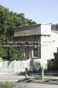 Eltham District Historical Society Inc
Photograph - Digital Photograph, Alan King, Little Bank Building, the former Commercial Bank of Australia Branch, Hurstbridge, 1 February 2008
The Little Bank Building at the corner of Anzac Avenue, formerly a Commercial Bank of Australia branch, was moved to Hurstbridge around 1917. It was one of a few portable branch buildings, towed by horse or bullock team to a site as required. The branch operated until the early 1980s. In 1985 it was moved about 42 metres south to the Allwood House grounds to become part of the Hurstbridge Neighbourhood House. Covered under Heritage Overlay, Nillumbik Planning Scheme. Published: Nillumbik Now and Then / Marguerite Marshall 2008; photographs Alan King with Marguerite Marshall.; p13This collection of almost 130 photos about places and people within the Shire of Nillumbik, an urban and rural municipality in Melbourne's north, contributes to an understanding of the history of the Shire. Published in 2008 immediately prior to the Black Saturday bushfires of February 7, 2009, it documents sites that were impacted, and in some cases destroyed by the fires. It includes photographs taken especially for the publication, creating a unique time capsule representing the Shire in the early 21st century. It remains the most recent comprehenesive publication devoted to the Shire's history connecting local residents to the past. nillumbik now and then (marshall-king) collection, cba bank, commercial bank of australia, hurstbridge, little bank building, portable buildings -
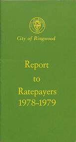 Ringwood and District Historical Society
Booklet, City of Ringwood Report to Ratepayers 1978-1979, 1978
Green covered community information booklet for Ringwood residents covering Council Representatives' and Service Organisations' contact details, Council Finances, Immunizations, Major Works, Planning (Live Theatre/Functions Centre), Health and Community Services, Christmas Holiday Play Centres, Lord Mayor's Children's Camp, Rates, Municipal Elections, Dogs, Rubbish Tip, Overhanging Foliage, Vandalism, Building By-laws, Fred Dwerryhouse Swimming Centre, Planning (Commercial Centre), Netball Complex, Citizenship Ceremonies, Mini Bikes, School Crossing Supervision, Ringwood Garden Competition, and Coming Events (International Year of the Child, Family Fun Day, Highland Carnival). Includes two City of Ringwood Free Tipping Vouchers valid until the end of 1979.Mayor's Message - Cr. A.B. Henderson, J.P. Back cover - Green tinted photograph of Ringwood Memorial Tower captioned: Ringwood - "A Happening Community"rinx -
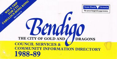 Bendigo Historical Society Inc.
Book - BOOKLET: ''BENDIGO THE CITY OF GOLD AND DRAGONS'' (1988-89)
45 paged booklet - ''Bendigo - The City of Gold and Dragons'' (1988-89)- a Council services and community information directory. Contents : Mayor's message; City of Bendigo; Exciting current developments; Council meeting times; Your councillors; Corporate plan; Chief Executive Officer's message; Corporate Services Department; Rates and valuations; Revaluation; Tourism; Parking and traffic control; Dogs; By-laws; Community development; Library; Health and Human Services Department; Child Care centres; Home Care services; Leisure; Engineering and Technical Services Dept.; Town planning; Building; Parks and recreation; Shopping guide/car parking; Discount shopping vouchers; Operations Department; Street lighting; Garbage collection. Photographs of councillors and Departmental managers/directors.bendigo, council, community information directory, cr. r. adams, colin nankervis, michael currie, james douglass, phillip geri, rodney fyffe, jeffrey fyffe, peter morley, chris wilson. rates and valuations, parking, by laws, shopping. departmental managers and directors. -
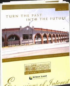 Melbourne Tram Museum
Document - Folder with papers, Urban Land corporation, "Hawthorn Tram Depot - Expressions of Interest Documentation", late 1998
White two spring clip folder with papers, titled "Hawthorn Tram Depot - Expressions of Interest Documentation", sub-titled "Turn the Past into the Future" Has a photo of Hawthorn Tram depot and an image on the front cover. Closing date 17/2/1999, prepared by the Urban Land Corporation with the assistance of VicTrack. Approx 110 pages with supplementary papers in the end covers. Contains a table of contents, checklist, EOI Process, Development Brief, Site conditions. Gives details of the heritage registration, site plans, building plans, property title and detailed room condition and use of the ground floor. Supplementary papers include the marketing brochure, letters and a detail feature and level survey by Bosco Johnson surveyors, 30-9-1998.trams, tramways, htt, hawthorn tram depot, sale of land, property -
 Vision Australia
Photograph - Image, St Kilda Road building in 2010, 6/1/2010
In 2007, Vision Australia sold it's iconic 557-563 St Kilda Road site. The historic bluestone building was in need of renovation and repair, had limited space for staff and clients and with more demand for services in suburban and regional areas, did not meet the needs of the national organisation. The purchaser was mainly interested in the Ormond Hall section, which they sub-divided off and sold to the tenant of the Belgian Beer Cafe. The remainder of the site was then sold on to another developer. Unable to quickly proceed with their plans on developing the site for residential buildings, the site fell into some disrepair in the interim which was when these images were taken. Later the site was sold again and residential buildings now occupy part of the block. 20 images taken of and from St Kilda Road buildingroyal victorian institute for the blind, buildings, myer house, ferguson and urie -
 Kew Historical Society Inc
Document, Kew Historical Society Collection : Preservation Needs Assessment, 2021
Following a Significance Assessment, in 2020, Kew Historical Society received a Community Heritage Grant from the National Library of Australia for a Preservation Needs Assessment, prepared by Grimwade Conservation Services (GCS). The purpose of the assessment was to consider the physical condition of the collection, the suitability of the current housing and storage facilities and to make recommendations for the development of a conservation program.Illustrated 87-page Final Report by Vanessa Kowalski (Grimwade Conservation Services), including - Executive Summary / p5. Key recommendations / p7. Policies and Procedures / p9. Collection / p11. Building (Repository Structure) / p25. Environment / p33. Storage / p41. Display/Exhibitions / p54. Housekeeping / p58. Visitor Impact / p51. Disaster Preparedness / p63. Training Needs/Skills Assessment / p65. Action Plan / p67. Authorship / p71. References / p73. Appendices / p75. non-fictionFollowing a Significance Assessment, in 2020, Kew Historical Society received a Community Heritage Grant from the National Library of Australia for a Preservation Needs Assessment, prepared by Grimwade Conservation Services (GCS). The purpose of the assessment was to consider the physical condition of the collection, the suitability of the current housing and storage facilities and to make recommendations for the development of a conservation program.preservation needs assessments, kew historical society -- collections, kew historical society - conservation, community heritage grants -
 Kew Historical Society Inc
Plan - Subdivision Plan, Jas R Mathers Son & McMillan, Macartney Estate, East Kew, c. 1925
Pru Sanderson, in her groundbreaking ‘City of Kew Urban Conservation Study : Volume 2 - Development History’ (1988), summarised the periods of urban development and subdivisions of land in Kew. The periods that she identified included 1845-1880, 1880-1893, 1893-1921, 1921-1933, 1933-1943, and Post-War Development. These periods were selected as they represented periods of rapid growth or decline in urban development. An obvious starting point for Sanderson’s groupings involved population growth and the associated economic cycles. These cycles also highlighted urban expansion onto land that was predominantly rural, although in other cases it represented the decline and breakup of large estates. A number of the plans in the Kew Historical Society’s collection can also be found in other collections, such as those of the State Library of Victoria and the Boroondara Library Service. A number are however unique to the collection.Subdivision plans are historically important documents used as evidence of the growth of suburbs in Australia. They frequently provide information about when the land was sold on which a built structure was subsequently constructed as well as evidence relating to surveyors and real estate and financial agents. The numerous subdivision plans in the Kew Historical Society's collection represent working documents, ranging from the initial sketches made in planning a subdivision to printed plans on which auctioneers or agents listed the prices for which individual lots were sold. In a number of cases, the reverse of a subdivision plan in the collection includes a photograph of a house that was also for sale by the agent. These photographs provide significant heritage information relating house design and decoration, fencing and household gardens.The Macartney Estate subdivision advertised 21 lots for sale on either side of Macartney Street (now Macartney Avenue) and Evans Road in what was then designated as East Kew. Most of the houses shown on the south side of Macartney Street then, as now, have rear entrances on Mount Street, however a number of these blocks have since been further subdivided to allow for the building of new houses on the rear of a block. Brougham Place is marked on the plan but is now called Daniell Place."C"subdivision plans - east kew, macartney estate, macartney street, mount street, evans road, brougham place -
Glen Eira Historical Society
Newsletter - Helenslea, Shelford|CEGGS
A photocopy of a two page article from the St Mary’s Church Chronicle of 16/12/1922, documenting the purchase of Helenslea by the Shelford School for St Mary’s Church. The article gives the deposit, price and background to the purchase, a brief description of the purchased building and planned alterations and also makes an appeal for funds. The article includes a black and white photograph (88mm x 154mm) of the exterior of Helenslea.shelford school, hood crescent, st mary’s church, caulfield north, st mary’s church chronicle, caulfield north, graham j moffitt, swale d h, smith sydney, smith ogg and serpell architects, dodgson miss, eggleston f w, falls mr, prendergast a l, slaney f, dumas mr, pollard mr, blundell miss, gill miss, beggs f g, beggs c, head mrs, hollow s, irwin t, lloyd m c, graham j m, eggleston f w, frederickson mrs, langley canon, askew a i, scales a w, dixon emily, glen eira road, blundell dora, seymour road, stephen george sir, douglas sholto, hood justice, ludbrook e c, helenslea, allison road, schools -
Bialik College
Mixed media (Series) - Planning for Sport and Recreation Centre
buildings, developmentbuildings, development -
 Eltham District Historical Society Inc
Document - Sales Brochure, Dallas Price Homes Pty Ltd, Eltham Hub: A Unique New Entry To Eltham's Town Centre; the facts about this multi purpose development, 1996
Produced by Contour Consultants Australia Pty Ltd on behalf of Dallas Price Homes Pty Ltd as part of the planning process for redevelopment of the former Eltham Shire Office site at 895 Main Road. In 1963 the Shire of Eltham purchased the Shillinglaw property of approximately 2 acres in Main Road, Eltham for the widening of Main Road and as a site for new Council offices. This land, which contained the Shillinglaw Cottage (c1878-80), was the remaining section of the Shillinglaw family holding that originally comprised 30 acres, being Lot 90 of Holloway's 1851 subdivision. Eltham Council intended to demolish this cottage, but through extensive community action it was saved, funds were raised, and it was relocated to the current site adjacent to the Eltham Library. The new Eltham Shire Offices opened in 1965 were designed to ensure retention of the three Italian Cypress trees that were located outside the Shillinglaw Cottage. In 1971 the building was extended at the southern end to provide additional space, including for the Eltham Library and Council's Engineering Department. Renovations were undertaken to the offices during 1987. The Victorian State Government commenced to restructure local government in 1994, which resulted in the establishment of the Shire of Nillumbik and the cessation of the Shire of Eltham. This new Nillumbik Shire Council was headed by government appointed commissioners, who decided in 1995 to put the former Eltham Shire offices on the market. Eventually in June 1996 the property was sold for $1.1 million and the building was subsequently demolished. A planning application for the site was then submitted to Nillumbik Shire Council in September 1996 for construction of a 24-hour service station, convenience store, cafe/takeaway food premises, a retail facility and community facility. There were many objections to this proposed development and in controversial circumstances a planning permit was granted by the Nillumbik Shire Council commissioners. After protracted actions involving a planning panel and a planning advisory committee, established by the Minister for Local Government, the proposal was eventually rejected as not satisfying the requirements of the planning scheme. In December 1997 the purchaser withdrew from the contract of sale, just prior to Council announcing a withdrawal from the contract. While there have been a number of possible development proposals considered by subsequent Nillumbik Shire Councils, this site has remained vacant since July 1996. TIMELINE (Prepared by Jim Connor, Eltham District Historical Society- March 2018- Based on press, council and personal records) June 1996 - Eltham Shire offices sold to Dallas Price Homes for $1.1 million. July 1996 - Shire office building demolished against community's wishes. Council claimed building riddled with asbestos. September 1996 - Planning application submitted to Nillumbik Shire Council to construct on the site a 24 hours Shell service station, convenience store, Hungry Jacks café/takeaway food premises, a retail facility and community facility. 213 objections and petition of over 1400 signatures received. Minister for Planning and Local Government orders an independent investigation into valuation and sale. 9 October 1996 - Permit granted by Nillumbik Shire Council commissioners, in controversial circumstances. A Planning Special Committee consisting of 3 commissioners and 3 community representatives considered 32 community objections. One commissioner declared a potential conflict of interest so only 2 commissioners were able to vote. After hearing all objections, the community representatives moved a foreshadowed motion to refuse a permit. The commissioners then closed the meeting, formerly opened a council meeting (for about a minute) and approved the application. October 1996 - Community members appealed planning decision to Administrative Appeals Tribunal. November 1996 -Minister for Planning and Local Government Robert McClelland calls appeal in and directs MT to refer this 'major policy issue' to the Governor in Council. February 1997 - Planning panel (Dimity Reed and Margaret Pitt) established to consider submissions. March 1997 - New council elected with five councillors. April 1997 - Three of the five new councillors vote to fight Commissioner's decision to grant a permit. April 1997 - Planning panel (Dimity Reed and Margaret Pitt) conducts hearings at Nillumbik Shire offices. June 1997 -Planning panel rejected Dallas Price Homes proposal as being 'totally inappropriate' for the site and recommends the site be rezoned for 'public purposes'. July 1997 - Dallas Price Homes threatened to sue Council and individual councillors. October 1997 - Report released of an Advisory Committee (Paul Jerome) established by the Minister for Planning and Local Government. Committee considered Dallas Price Homes proposal and an alternative concept plan proposal by Council for a gallery, workshop, offices and cinema community-based development. Advisory Committee recommended Dallas Price Homes proposal be rejected as not satisfying the requirements of the planning scheme and recommended further testing of the financial viability of Council's proposal. December 1997 - Dallas Price Homes withdrew from the contract of sale, just prior to Council announcing a withdrawal from the contract, which expired on 28th November and was not renewed by either side, after previously being extended twice pending a decision by the Minister. Council had to pay developer $58,000 for demolition costs. February 1998 - Dallas Price Homes application rejected by Planning and Local Government Minister. October 1998 - Nillumbik Councillors suspended and an Administrator appointed (until March 1999). The demolition of the former Shire of Eltham offices and proposed sale and development driven by the Commissioners for Nillumbik Shire Council brought the community together in substantial protest at the infrigement of ratepayers democratic say in local government and ciommunity assets combined with protests about inappropraite development of Eltham's Gateway. This issue led to the formation of the Eltham Community Action Group which still operates strongly today (2023) on behalf of the community to ensure appropriate development within the community.895 main road, commissioners, dallas price homes, development application, eltham hub, hungry jacks, nillumbik shire council, re-zoning, shell service station, town planning, eltham gateway, eltham gateway action group, eltham shire offices, shillinglaw cottage, shillinglaw farm, shillinglaw trees, jim connor collection -
 Eltham District Historical Society Inc
Photograph - Digital Photograph, Alan King, Original Kangaroo Ground Primary School No. 2105 building, Eltham-Yarra Glen Road, Kangaroo Ground, 28 December 2007
Kangaroo Ground's first school began in 1851 with 22 pupils from the district's ten families. It was a single room school located further south on the site, which also served as a Presbyterian church. The first teacher was Andrew Ross. The school building was used as a Post Office between 1854 and 1858 and during 1857 also served as a Court of Petty Sessions. With a growing farming community, a new building was warranted and the original Sate School No. 352 was closed and a new building, State School No. 2105 was oipened October 1, 1878. A residence for Head Teacher Henry Wallace School was erected in 1879 attached to the left of the school building. That residence is now home to the Andrew Ross Museum, which opened in 1993. Covered under Heritage Overlay, Nillumbik Planning Scheme. Published: Nillumbik Now and Then / Marguerite Marshall 2008; photographs Alan King with Marguerite Marshall.; p35This collection of almost 130 photos about places and people within the Shire of Nillumbik, an urban and rural municipality in Melbourne's north, contributes to an understanding of the history of the Shire. Published in 2008 immediately prior to the Black Saturday bushfires of February 7, 2009, it documents sites that were impacted, and in some cases destroyed by the fires. It includes photographs taken especially for the publication, creating a unique time capsule representing the Shire in the early 21st century. It remains the most recent comprehenesive publication devoted to the Shire's history connecting local residents to the past. nillumbik now and then (marshall-king) collection, kangaroo ground, eltham-yarra glen road, kangaroo ground primary school no. 2105, kangaroo ground state school, state school no. 2105 -
Glen Eira Historical Society
Letter - Trinity Congregational Church, Glen Huntly
Roneod letter from the National Trust, Victoria, to the Congregational Union of Victoria. The correspondence gives notification that the church has been placed in the classified List and should be preserved. Dated 20/03/1973. Correspondence from Department of Planning Victoria, advising the Caulfield Historical Society, that the H. B. Council has chosen not to recommend the building for addition to the Historic Buildings Register Dated 08/10/1982. Extracted From Caulfield Conservation Study By Andrew Ward Dated January 1995 Describing Trinity Congregational Church. Includes Brief History Of The Church And Description Of Architectural Features.trinity congregational church., moran b., preston joane, grange road, caulfield., historic buildings council, glen huntly, hart trevor, grey karen, timber houses, filbert street, old calendar greek, primitive methodists, caulfield south, orthodox church, el nido grove, lyons street, porches, market gardens., gothic style, congregationalists, ward andrew, architectural features, architectural styles -
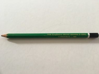 Warrnambool and District Historical Society Inc.
Artefact, Archie Graham & Son Warrnambool - 4423, Mid 20th century
This pencil was used as an advertising medium for the Warrnambool firm of Archie Graham and Sons. It was given to customers of the firm. Archie Graham (1906-1992) commenced a building business in Warrnambool in the 1930s and was well-known for his many building projects in the city and his innovation in the industry. Archie Graham was a prominent member of the Uniting Church and a tireless worker in community affairs in Warrnambool for sixty years. He planned and organized the street decorations for the Warrnambool Centenary in 1947, was chairman of the committee that developed Albert Park and the Reid Oval and was active in Rotary Club and Cricket Club affairs. He was also a member of the Warrnambool Technical School Council. Today the building in Timor Street for senior citizens and other community use is named after Archie Graham. This pencil is of interest as a memento of the type of complimentary article given to customers of businesses in Warrnambool in the mid 20th century. It is also a memento of Archie Graham, an important businessman and community worker in Warrnambool in the 20th century. This is a large six-sided wooden pencil sharpened at one end. The pencil is painted green with a white band near the top and a black-colored end rounded at the top. The paint on the pencil is slightly chipped. The inside of the pencil contains graphite for writing or drawing. The business name on the side of the pencil is inscribed in gold lettering. ‘With Compliments ARCHIE GRAHAM & SONS WARRNAMBOOL – 4422’ archie graham, warrnambool, history of warrnambool -
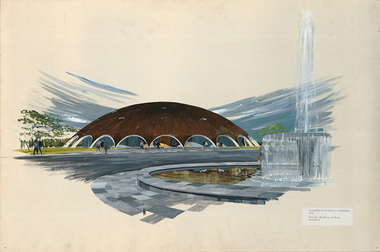 RMIT Design Archives
Work on paper - Paintings, Academy of Science, Canberra
The Shine Dome is one of seven projects that the Royal Australian Institute of Architects has nominated to the World Register of Significant Twentieth Century Architecture. In 1956 six architects were invited to submit plans for the Academy of Science's new building in Canberra and the Academy's building design committee selected Grounds Romberg and Boyd's proposal designed by Roy Grounds. It features a shallow arcaded concrete dome, sheeted in copper and was one of a number of domed buildings that appeared around this time internationally, expressing the optimism of the post-war years. It perfectly reflected the Academy's ambition to champion excellence in Australian science and promote international scientific engagement. Paul Wallace, a well-known Melbourne renderer, drew this perspective of the proposed design, possibly for the competition submission, in 1956.Coloured perspective of the Academy of Science buiding in Canberra.Printed text on attached sticker, 'ACADEMY OF SCIENCE, CANBERRA / 1958 / Grounds, Romberg and Boyd, / Architects'. Printed centre on verso, 'ACADEMY OF SCIENCE CANBERRA GROUND, ROMBERG AND BOYD ARCHITECTS 340 ALBERT STE., MELBOURNE C2'.science, canberra, architecture, rmit design archives, design -
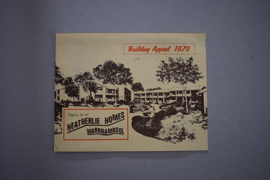 Warrnambool and District Historical Society Inc.
Booklets, Collett, Bain and Gaspar, Printers, 1 Heatherlie Homes Building Appeal 1979 .2 Heatherlie Warrnambool, 1979, 1981
These booklets come from the estate of Brue Morris, editor of the Warrnambool Standard from 1946 to 1968. He was an important historian in Warrnambool, writing many historical articles for the Standard newspaper during his editorship and after his retirement. He kept files and other material on many topics related to Warrnambool’s history and Heatherlie was one of these. Heatherlie is a site in Koroit Street Warrnambool occupied by flats for the elderly. The name comes from the name of the original property owned by the Warrnambool furniture maker and seller, E.B. Phillips. Heatherlie Homes is a project established in 1979 under the auspices of the Methodist Church in Warrnambool and today the project is operated by a Uniting Church committee. These two booklets are of historical interest detailing the establishment of Heatherlie Homes in Warrnambool and the history of the property and its buildings in 1981. The booklets are useful to researchers..1 This is a booklet of 8 pages with black print on a buff-coloured background. The cover has a sketch of the proposed Heatherlie project. The booklet has plans, sepia-coloured photographs and information for donors. There are two loose flyers re the appeal. .2 This is a booklet of 22 pages. It has an orange cover with reproductions of the building opening plaque and a Uniting Church statement. The booklet contains historical facts about Heatherlie and the Uniting Church and reports on Heatherlie’s progress. It also has several black and white photographs. heatherlie homes, warrnambool, bruce morris, warrnambool standard editor, warrnambool uniting church -
Bendigo Historical Society Inc.
Accessory - F. G. JONES COLLECTION: MASONIC DECORATIONS X 2, 1940's
Object. 1 - Life Governors Medal on sky blue ribbon for Freemasons Homes of Victoria. Small gold front plan of a building mounted centrally to ribbon. Medallion shows a 5 pointed star over a laurel wreath. Gold coloured compass & square on blue enamel background mounted in centre, long pin on the back. 2 - Keystone medal, burgundy & grey ribbon with mallet & chisel motif in metal, small white stone with lettering 'KSHT WSST' and Hebrew characters on reverse.societies, freemasons, regalia, f.g. jones collection, masonic decorations x 2 -
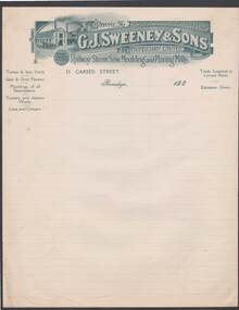 Bendigo Historical Society Inc.
Document - CAMBRIDGE PRESS COLLECTION: ACCOUNT - G. J. SWEENEY AND SON
Note/account paper with date line ending 192-. Lined paper with greenish grey printed letterhead G. J. Sweeney & Sons Propriety Limited, Railway Steam Saw, Moulding and Planing Mills. Printed letterhead has a building with two tall chimneys and a horse and lorry at the side on the left and the name and phone number on the right side. Also Mining timber prepared. On the back is a stamped Sample with Cambridge Press and the date 26/4/24. Stamped in blue.business, printers, cambridge press, cambridge press collection, g j sweeney & sons proprietary limited, cambridge press -
Churchill Island Heritage Farm
Newspaper - "The Good, The Bad and the Ugly Revealed, Survey", 11/7/2007
... planning ...Photocopies of newspaper article series in Phillip Island and San Remo Advertiser Wednesday July 11 2007. Pp 1, 6, 10. Part 2 of "SOS: Save Our Shores" Pg. 1 article states Churchill Island visitors centre topped list of 21 local buildings for good planning and design. Pg. 6 = survey of community re: development. Pg. 10 re: Eco Resort, Silverwater development and Bass Coast Shire Council's 5 major strategies. churchill island visitors centre, planning, phillip island, bass coast shire council -
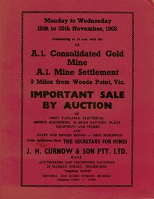 Bendigo Historical Society Inc.
Document - IAN DYETT COLLECTION: AUCTION CATALOGUE - A1 CONSOLIDATED GOLD MINE
Three red covered auction catalogues for a sale on the 18th to 20th November, 1968 at the A.1. Consolidated Gold Mine A.1. Mine Settlement, 9 Miles from Woods Point, Vic. For sale was Most Valuable Electrical Mining Machinery, 20 Head Battery, Plant Equipment and Stores and Staff and Miners Homes - Mine Buildings Under Instruction from The Secretary for Mines. Also for sale was the Lease No. 8317 Beechworth. Catalogue has a Sketch Plan showing Mine Property.business, auctioneers, j h curnow & son pty ltd, ian dyett collection - auction catalogue - a1 consolidated gold mine, the secretary for mines, j h curnow & son pty ltd, f c dyett, l c osborne, clem hill, t apps, bolton's print -
 Falls Creek Historical Society
Document - Circular To All Licensees - Intention To Build During Any Particular Summer, 02.04.1963
Bob (Herman) Hymans (a former member of the Royal Netherlands Navy) was born in Bloemendaal, Holland on 30th September 1922. During World War II he fought against the Japanese in the Dutch East Indies (now Indonesia) and was imprisoned in Changi and on the Burma Railway. After gaining qualifications as a Ski Instructor, Bob arrived in Falls Creek in July 1950. Working as an Instructor and Supervisor at Bogong Lodge, Bob decided his future was in accommodation. He was successful in negotiating an indenture for land from the State Electricity Commission (SEC). It took Bob two years to build his Grand Coeur Chalet but, tragically, it was burned down in August 1961. Bob also built the first Chairlift in Australia. This was a single chairlift and the structure was built from wooden electricity poles. He was constantly full of new ideas and proposals for the village. Bob Hymans die on 7th July 2007. This Collection of documents and letters tells the story of Bob's endeavours to develop Falls Creek into the ski village it is today.This item is significant because it documents actions taken by the Falls Creek Tourist Area Management Committee in their role overseeing the Tourist Area.A circular from the Management Committee indicating changes made to the timeline for submission of plans for new building at Falls Creek. As all sites in the Tourist Area had virtually been allocated, it had been decided to bring forward the latest date for the submission of final working drawings end specifications to 30th June, 1983, for those wishing to build or alterations and additions during the summer of 1963-61. Someone had written a note on the circular drawing it to Bob Hymans' attention.falls creek tourist area management committee, hymans' hotel plans, falls creek development -
Warrnambool and District Historical Society Inc.
Document - Documents (St. Ann’s ), letter, Mid 20th century
These items come from the estates of Dorothy and Agnes Ardlie of Warrnambool. Dorothy Ardlie (1910-1993) and her sister Agnes (1915-1993) were the daughters of law clerk Arthur Ardlie and his wife Ethel, the granddaughters of the prominent Warrnambool lawyer, William Ardlie and his wife Mary and the great granddaughters of John and Mary Ardlie, pioneer settlers in Warrnambool. All of the documents relate to St. Ann’s Convent/School in Warrnambool. The Sisters of Mercy established St Mary’s Wyton school in 1872 and the name was changed to St.Ann’s in 1888. Dorothy and Agnes Ardlie would have been particularly interested in the convent building established around the original building of Wyton as this building had been the home of John Ardlie and had been sold to the Sisters of Mercy by their grandfather, William Ardlie. Dorothy and Agnes Ardlie had been pupils at St. Ann’s School. Some of the documents relate to the orphanage established at St. Ann’s in 1881 when an extension was added to the convent for that purpose. The orphanage was closed when a similar institution, Nazareth House, was opened in Ballarat. Thes items are of minor interest as material compiled by the Ardlie sisters, Dorothy and Agnes, residents of Warrnambool in the 20th century. .1 A sheet of paper containing a letter handwritten in black ink and an envelope with the address handwritten in black ink .2 A sheet of paper containing a letter handwritten in blue ink .3 A black and white photograph of St. Ann’s Convent .4 Two sheets of blue paper with rough plans of St. Ann’s building interior .5 A sheet of paper with a black and white sketch of St. Ann’s Convent .6 A sheet of white paper with photocopies of two newspaper cuttingsardlie family, warrnambool, st. ann’s convent -
 Port Melbourne Historical & Preservation Society
Photograph - Construction of Bank Houses, Jack GOULD
From a box of photographs in Nancy U'REN's papers used during research for her thesis, The Early Growth and Development of Sandridge (1976) and/or her book with Noel TURNBULL, A History of Port Melbourne (1983). Comparing the form and location of the doors and windows with plans for the various types of Bank Houses, the semi-detached building on the right appears to be Type 5. Jack GOULD probably created this from an earlier photograph.Black and white photograph across vacant ground to the construction of some Bank Houses.bank houses, garden city, nancy u'ren nee morris -
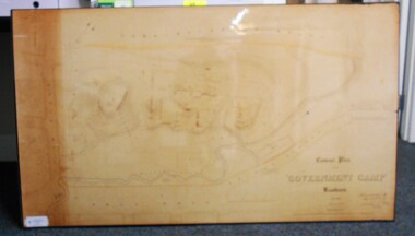 Bendigo Historical Society Inc.
Map - CONTOUR PLAN OF THE GOVERNMENT CAMP SANDHURST 1854, 1994
Contour map (copy) of the Government Camp Sandhurst, 1854. Map is mounted on coreflute and laminated. Written in bottom righthand corner 'Contour Plan of the Government Camp, Sandhurst. Dec 1854. Signed by Richard Larritt, Assistant Surveyor, 11th December 1854.' Shown on map: Pall Mall, Bendigo Creek, Commissioner's Gully, View Place (now View Street), Post Office, Bank of Victoria, District Surgeon, Sandhurst Fire Brigade, Police Hospital, Flagstaff, Gold Office, License Shed, Military Barracks, Stables, Commissioner's Buildings, Police Office. Old Cemetery, Garden. Reference on righthand side: 'Stone or brick buildings are tinted in crimson. Wooden buildings tinted in Indian Ink. Tents and other temporary structures tinted in Burnt Sienna.' Scale of Chains, on bottom of map. Sticker on bottom left hand corner and back of map ' Presented by Survey and Mapping, Victoria, 7th Octber, 1994'.map, bendigo, government camp, pall mall, bendigo creek, commissioner's gully, view place (now view street), post office, bank of victoria, district surgeon, sandhurst fire brigade, police hospital, flagstaff, gold office, license shed, military barracks, stables, commissioner's buildings, police office. old cemetery, garden. , survey and mapping victoria. sandhurst, bendigo. -
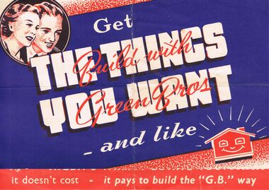 Bendigo Historical Society Inc.
Memorabilia - GREEN BROS BUILDING CONTRACTORS ADVERTISING BROCHURE
BHS CollectionGreen Bros building Contractors Advertising Brochure:-On cream paper background with red, black and blue print, has *Get The Things You Want - and like. Across these words in red ink is *Build with Green Bros* Top left corner in a circle is a man and women's faces smiling down at the words. Bottom right is a caricature of a smiling house. Open the brochure and it tells you about the company *G. B.'Is The Buy Word For All Types of Buildings - Houses, Hall, Garage or Shearers' Hut. See Green Bros Always. Green Bros Building Contractors Epsom, Via Bendigo, Phone 26 Huntly Branch: Henry St Deniliquin, Phone Deniliquin 88. Also is a drawing of a house plan. On the left side is 4 large red dots down the page and caricature of people enjoying themselves. On the Back is Advertising for House Moving Specialists. Bendigo Heavy Haulage Co. Box 625buildings, house, green bros builders., green bros builders. bendigo heavy haulage co. -
 Eltham District Historical Society Inc
Photograph, Liz Pidgeon, Heritage Excursion; The 1901 Eltham Railway Walk, 3 May 2014, 3 May 2014
Newsletter No. 216, May 2014 May Excursion – The 1901 Eltham Railway Walk The railway from Heidelberg to Eltham was opened in 1902. Over the previous year railway construction cut a curving swathe through Josiah Holloway’s 1851 Little Eltham subdivision. The survey plans for the railway show the owners and occupiers of land within Little Eltham affected by the railway alignment and for some distance each side. The plans show houses and other buildings but development at that time was rather sparse. Copies of these plans from the State Library of Victoria collection have been provided to the Society by Alan Sheehan. For our walk on 3rd May we intend to follow the railway from the Eltham Station to Ryans Road, which was the boundary of the adjoining Montmorency Farm. The return will be by way of nearby streets. Along the way we will discuss the details shown on the railway plans as well as more recent railway documents and photographs. At the conclusion and if time permits we can inspect the historical display at the Eltham Station. The walk is about 3 km in length and will take about 2.5 hours. It will start at 2 pm at the Eltham Railway Station car park (east/Main Road side) (Melway Ref. 21 J5).Born Digitalheritage excursion, activities, eltham district historical society, eltham railway station, eltham library, trestle bridge -
 Eltham District Historical Society Inc
Photograph, Liz Pidgeon, Heritage Excursion; The 1901 Eltham Railway Walk, 3 May 2014, 3 May 2014
Newsletter No. 216, May 2014 May Excursion – The 1901 Eltham Railway Walk The railway from Heidelberg to Eltham was opened in 1902. Over the previous year railway construction cut a curving swathe through Josiah Holloway’s 1851 Little Eltham subdivision. The survey plans for the railway show the owners and occupiers of land within Little Eltham affected by the railway alignment and for some distance each side. The plans show houses and other buildings but development at that time was rather sparse. Copies of these plans from the State Library of Victoria collection have been provided to the Society by Alan Sheehan. For our walk on 3rd May we intend to follow the railway from the Eltham Station to Ryans Road, which was the boundary of the adjoining Montmorency Farm. The return will be by way of nearby streets. Along the way we will discuss the details shown on the railway plans as well as more recent railway documents and photographs. At the conclusion and if time permits we can inspect the historical display at the Eltham Station. The walk is about 3 km in length and will take about 2.5 hours. It will start at 2 pm at the Eltham Railway Station car park (east/Main Road side) (Melway Ref. 21 J5).Born Digitalheritage excursion, activities, eltham district historical society, eltham railway station, eltham library, trestle bridge