Showing 1247 items matching "clasps"
-
 Eltham District Historical Society Inc
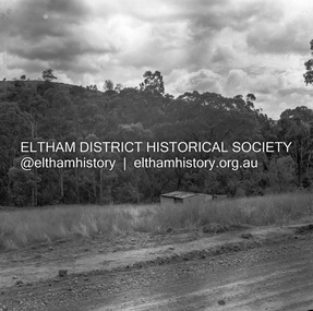
Negative - Photograph, J.A. McDonald, Road Reserve Housing, Mar. 1961
Shack built on road reserve without permit Most probably up on Simms Road, Kinglake Other areas where illegal shacks were built were at the junction of Flat Rock Road and Cherry Tree Road, Hurstbridge. At times, Building Surveyor George E Newton would have to attend to these shacks for inspection and issue demolition ordersRecord of various Shire of Eltham infrastructure works undertaken during the period of 1952-1962 involving bridge and road reconstruction projects, sometimes with Eltham Shire Council Project Reference numbers quoted. It was during this period that a number of significant improvements were made to roads and new bridges constructed within the shire that remain in place as of present day (2022). In many situations, the photos provide a tangible visible record of infrastructure that existed throughout the early days of the Shire. The album was put together by or under the direction of the Shire Engineer, J.A. McDonald.infrastructure, shire of eltham, 1961-03, building surveyor, cherry tree road, flat rock road, george e. newton, houses, hurstbridge, kinglake, road reserve, road reserve housing, scan - 120 format 6x6 negative, shack, simms road -
 Eltham District Historical Society Inc
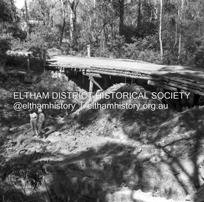
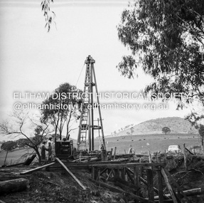
Negative - Photograph, J.A. McDonald, Henley Road at Watsons Creek, Mar. 1961
Old bridge over Watsons Creek 22 March 1961 Cr. Pelling and Contractor WolfRecord of various Shire of Eltham infrastructure works undertaken during the period of 1952-1962 involving bridge and road reconstruction projects, sometimes with Eltham Shire Council Project Reference numbers quoted. It was during this period that a number of significant improvements were made to roads and new bridges constructed within the shire that remain in place as of present day (2022). In many situations, the photos provide a tangible visible record of infrastructure that existed throughout the early days of the Shire. The album was put together by or under the direction of the Shire Engineer, J.A. McDonald.infrastructure, shire of eltham, 1961-03, bend of islands, cr. charis pelling, henley road, henley road bridge, kangaroo ground, oxley bridge, watsons creek, w.e. wolf, bridge construction, road construction -
 Eltham District Historical Society Inc
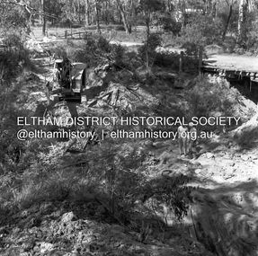
Negative - Photograph, J.A. McDonald, Henley Road at Watsons Creek, Mar. 1961
Henley Road at Watsons Creek Looking easterly along new alignment, 22 March 1961 C. Browns Excavator Contractor Wolf Cr PellingRecord of various Shire of Eltham infrastructure works undertaken during the period of 1952-1962 involving bridge and road reconstruction projects, sometimes with Eltham Shire Council Project Reference numbers quoted. It was during this period that a number of significant improvements were made to roads and new bridges constructed within the shire that remain in place as of present day (2022). In many situations, the photos provide a tangible visible record of infrastructure that existed throughout the early days of the Shire. The album was put together by or under the direction of the Shire Engineer, J.A. McDonald.infrastructure, shire of eltham, 1961-03, bend of islands, cr. charis pelling, henley road, henley road bridge, kangaroo ground, oxley bridge, watsons creek, w.e. wolf, bridge construction, road construction -
 Eltham District Historical Society Inc
Negative - Photograph, J.A. McDonald, Eltham, Haldane Road, Mar. 1961
Dr Donald Thomson's gate and entrance to his property 'Worlingworth' after flooding in March 1961 "Worlingworth", Eltham, was the home of noted anthropologist the late Professor Donald Thomson and his wife Dorita. The entrance gate on Banoon Road is located at the bottom of the hill opposite Haldane Road. The flooding issues were regularly reported to Council following heavy rain. Google Street View Feb 2014 https://goo.gl/maps/SGjsJAAEdjQXgo5V9Record of various Shire of Eltham infrastructure works undertaken during the period of 1952-1962 involving bridge and road reconstruction projects, sometimes with Eltham Shire Council Project Reference numbers quoted. It was during this period that a number of significant improvements were made to roads and new bridges constructed within the shire that remain in place as of present day (2022). In many situations, the photos provide a tangible visible record of infrastructure that existed throughout the early days of the Shire. The album was put together by or under the direction of the Shire Engineer, J.A. McDonald.infrastructure, shire of eltham, 1961-03, flood damage, haldane road, prof donald thomson, worlingworth -
 Eltham District Historical Society Inc
Negative - Photograph, J.A. McDonald, Para Road, Mar. 1961
Wash out 51 Para Road after heavy rain 28 March 1961Record of various Shire of Eltham infrastructure works undertaken during the period of 1952-1962 involving bridge and road reconstruction projects, sometimes with Eltham Shire Council Project Reference numbers quoted. It was during this period that a number of significant improvements were made to roads and new bridges constructed within the shire that remain in place as of present day (2022). In many situations, the photos provide a tangible visible record of infrastructure that existed throughout the early days of the Shire. The album was put together by or under the direction of the Shire Engineer, J.A. McDonald.infrastructure, shire of eltham, 1961-03, flood damage, para road -
 Eltham District Historical Society Inc
Negative - Photograph, J.A. McDonald, Henley Road at Watsons Creek, Apr. 1961
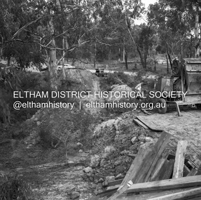
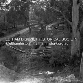
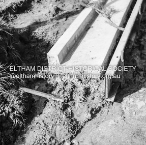
Henley Road at Watsons Creek looking easterly along centreline from west abutment Early April 1961Record of various Shire of Eltham infrastructure works undertaken during the period of 1952-1962 involving bridge and road reconstruction projects, sometimes with Eltham Shire Council Project Reference numbers quoted. It was during this period that a number of significant improvements were made to roads and new bridges constructed within the shire that remain in place as of present day (2022). In many situations, the photos provide a tangible visible record of infrastructure that existed throughout the early days of the Shire. The album was put together by or under the direction of the Shire Engineer, J.A. McDonald.infrastructure, shire of eltham, bend of islands, cr. charis pelling, henley road, henley road bridge, kangaroo ground, oxley bridge, watsons creek, w.e. wolf, bridge construction, road construction, 1961-04 -
 Eltham District Historical Society Inc
Negative - Photograph, J.A. McDonald, Henley Road at Watsons Creek, Apr. 1961
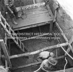
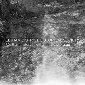
Henley Road at Watsons Creek showing excavation at western pier Rock at contract level, slight underground flow Early April 1961Record of various Shire of Eltham infrastructure works undertaken during the period of 1952-1962 involving bridge and road reconstruction projects, sometimes with Eltham Shire Council Project Reference numbers quoted. It was during this period that a number of significant improvements were made to roads and new bridges constructed within the shire that remain in place as of present day (2022). In many situations, the photos provide a tangible visible record of infrastructure that existed throughout the early days of the Shire. The album was put together by or under the direction of the Shire Engineer, J.A. McDonald.infrastructure, shire of eltham, bend of islands, cr. charis pelling, henley road, henley road bridge, kangaroo ground, oxley bridge, watsons creek, w.e. wolf, bridge construction, road construction, 1961-04 -
 Eltham District Historical Society Inc
Negative - Photograph, J.A. McDonald, Henley Road at Watsons Creek, Apr. 1961
Henley Road at Watsons Creek looking westerly along centreline from east abutment Early April 1961Record of various Shire of Eltham infrastructure works undertaken during the period of 1952-1962 involving bridge and road reconstruction projects, sometimes with Eltham Shire Council Project Reference numbers quoted. It was during this period that a number of significant improvements were made to roads and new bridges constructed within the shire that remain in place as of present day (2022). In many situations, the photos provide a tangible visible record of infrastructure that existed throughout the early days of the Shire. The album was put together by or under the direction of the Shire Engineer, J.A. McDonald.infrastructure, shire of eltham, bend of islands, cr. charis pelling, henley road, henley road bridge, kangaroo ground, oxley bridge, watsons creek, w.e. wolf, bridge construction, road construction, 1961-04 -
 Eltham District Historical Society Inc
Negative - Photograph, J.A. McDonald, Henley Road at Watsons Creek, Apr. 1961
Henley Road at Watsons Creek looking westerly showing west abutment excavation Mid April 1961Record of various Shire of Eltham infrastructure works undertaken during the period of 1952-1962 involving bridge and road reconstruction projects, sometimes with Eltham Shire Council Project Reference numbers quoted. It was during this period that a number of significant improvements were made to roads and new bridges constructed within the shire that remain in place as of present day (2022). In many situations, the photos provide a tangible visible record of infrastructure that existed throughout the early days of the Shire. The album was put together by or under the direction of the Shire Engineer, J.A. McDonald.infrastructure, shire of eltham, bend of islands, cr. charis pelling, henley road, henley road bridge, kangaroo ground, oxley bridge, watsons creek, w.e. wolf, bridge construction, road construction, 1961-04 -
 Eltham District Historical Society Inc
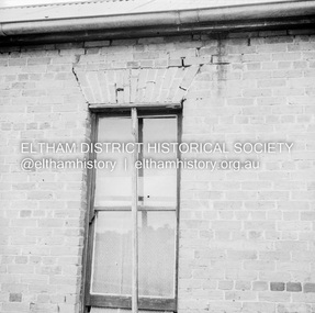
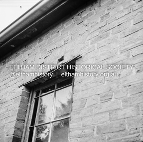
Negative - Photograph, J.A. McDonald, Old house, Susan Street, Eltham, c. 1962
Williams house, Susan StreetRecord of various Shire of Eltham infrastructure works undertaken during the period of 1952-1962 involving bridge and road reconstruction projects, sometimes with Eltham Shire Council Project Reference numbers quoted. It was during this period that a number of significant improvements were made to roads and new bridges constructed within the shire that remain in place as of present day (2022). In many situations, the photos provide a tangible visible record of infrastructure that existed throughout the early days of the Shire. The album was put together by or under the direction of the Shire Engineer, J.A. McDonald.eltham, houses, susan street, williams house -
 Eltham District Historical Society Inc
Negative - Photograph, J.A. McDonald, Old house, Susan Street, Eltham, c. 1962
Williams house, Susan StreetRecord of various Shire of Eltham infrastructure works undertaken during the period of 1952-1962 involving bridge and road reconstruction projects, sometimes with Eltham Shire Council Project Reference numbers quoted. It was during this period that a number of significant improvements were made to roads and new bridges constructed within the shire that remain in place as of present day (2022). In many situations, the photos provide a tangible visible record of infrastructure that existed throughout the early days of the Shire. The album was put together by or under the direction of the Shire Engineer, J.A. McDonald.eltham, houses, susan street, williams house -
 Bendigo Historical Society Inc.
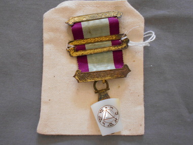
Clothing - JOHN FREDERICK HARPER COLLECTION: LODGE REGALIA LAPEL OR SASH PIN, 1965
Clothing. Lapel pin with three metal bars in a brass-like finish, across a 4.5 cm long ribbon. The ribbon has a burgandy coloured stripe, 7.5 cm wide at either side with a 1.75 cm light blue stripe in the centre. A floral design on each of the clasps. A 2.25 cm long x 2.cm wide at the top, plastic/perspex shape, with black Lodge Symbols hang from the suspender at the base of the ribbon.costume, male, lodge regalia sash pin -
 Anglesea and District Historical Society
Mourning jewellery, Estimated 1850
Three pieces of Black Jet Mourning Jewellery - one small and one larger bracelet and one brooch. 1. Small bracelet narrower and overlapping at back, with ornately carved thistle centrefront in same black jet material. 2. Larger bracelet with gap at centre back, same ornate thistle on front as on smaller piece. 3. Carved black jet brooch, oval in shape depicting spray of flowers with metal clasp on back.bangle, brooch, black jet, lignite, mourning jewellery -
 Clunes Museum
Sign - FIRE MARKS, Bayley, Bill
Developed in England from 1667 after the Fire of London. Originally made of lead. Up to 1708 had the policy number on each plaque..1 Black plaque, raised circle, gold border and lettering "British" in bottom, lion with paw on wheel depicting British Flag .2 Black plaque, gold "sun"with face, number at bottom .3 Black plaque, thistle in circle, "Caledonia" on banner .4 Black plaque, Crown at top, clasped hand centre, number a base .5 Black plaque, oval raised with fire inside, ribbon banner at top, number at bottom.1 British .2 Sun .3 Caledonian .4 Hand in Hand .5 Salamander and Western firemark, plaque, fire office -
 Eltham District Historical Society Inc
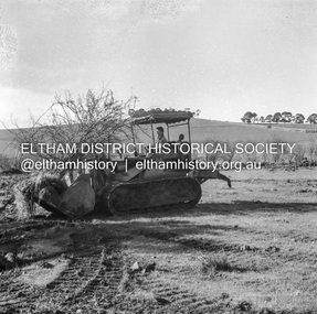
Negative - Photograph, J.A. McDonald, Kangaroo Ground-Queenstown Road, Aug. 1960
(Kangaroo Ground-St Andrews Road) “Rymers” Corner – shifting Hawthorn hedges on Tompkins property Council’s Drott 6 Woods Drott 9 August 1960 Showing hedge in rear already transported EDHS_05569-55 (EDHS_05577-3/4) and EDHS_05569-56 (EDHS_05577-5/6) - Hawthorn Hedges, Kangaroo Ground 50-50 ELTHAM, CUT THE HEDGES! While all of us are talking about the road toll, Eltham Council must have been in long recess. Around Kangaroo Ground are farmers’ hawthorn hedges shrouding dangerous corners on busy roads. If the council does not insist on their removal for a distance clear enough for safe driving, then it must be held culpable for the accidents that are bound to happen. – WAKE UP (Melbourne) ELTHAM, CUT THE HEDGES! 50-50 (1960, 6 January), The Sun (News clipping held in SEA_74-1_007) ‘BAD HEDGES’ WILL GO “We know there are some bad hedges on corners in the Kangaroo Ground area, but roadworks this year will eliminate them,” the Eltham Shire secretary, Mr Maxwell B. Watson, said yesterday. A reader in 50-50 yesterday complained of farmers’ hawthorn hedges obscuring drivers’ views at bad corners on busy roads in the Kangaroo Ground district. Mr Watson said the roadworks were deviations to remove the sharp turns, and the road would cut back into paddocks. The hedges would go at the same time. Meanwhile, the shire had power to require owners to cut back hedges, and this would be done if specific instances were reported and found justifiable. ‘BAD HEDGES’ WILL GO (1960, January 7), The Sun (News clipping held in SEA_74-1_007)Record of various Shire of Eltham infrastructure works undertaken during the period of 1952-1962 involving bridge and road reconstruction projects, sometimes with Eltham Shire Council Project Reference numbers quoted. It was during this period that a number of significant improvements were made to roads and new bridges constructed within the shire that remain in place as of present day (2022). In many situations, the photos provide a tangible visible record of infrastructure that existed throughout the early days of the Shire. The album was put together by or under the direction of the Shire Engineer, J.A. McDonald.infrastructure, shire of eltham, 1960-08, garden hill, kangaroo ground, kangaroo ground-queenstown road, kangaroo ground-st andrews road, rymers corner, bulldozer, drott -
 Eltham District Historical Society Inc
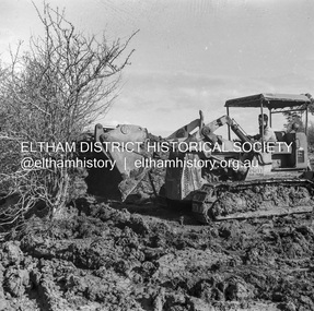
Negative - Photograph, J.A. McDonald, Kangaroo Ground-Queenstown Road, Aug. 1960
(Kangaroo Ground-St Andrews Road) “Rymers” Corner – shifting Hawthorn hedges on Tompkins property Council’s Drott 6 Woods Drott 9 August 1960 Showing method of lifting clumps of Hawthorn EDHS_05569-55 (EDHS_05577-3/4) and EDHS_05569-56 (EDHS_05577-5/6) - Hawthorn Hedges, Kangaroo Ground 50-50 ELTHAM, CUT THE HEDGES! While all of us are talking about the road toll, Eltham Council must have been in long recess. Around Kangaroo Ground are farmers’ hawthorn hedges shrouding dangerous corners on busy roads. If the council does not insist on their removal for a distance clear enough for safe driving, then it must be held culpable for the accidents that are bound to happen. – WAKE UP (Melbourne) ELTHAM, CUT THE HEDGES! 50-50 (1960, 6 January), The Sun (News clipping held in SEA_74-1_007) ‘BAD HEDGES’ WILL GO “We know there are some bad hedges on corners in the Kangaroo Ground area, but roadworks this year will eliminate them,” the Eltham Shire secretary, Mr Maxwell B. Watson, said yesterday. A reader in 50-50 yesterday complained of farmers’ hawthorn hedges obscuring drivers’ views at bad corners on busy roads in the Kangaroo Ground district. Mr Watson said the roadworks were deviations to remove the sharp turns, and the road would cut back into paddocks. The hedges would go at the same time. Meanwhile, the shire had power to require owners to cut back hedges, and this would be done if specific instances were reported and found justifiable. ‘BAD HEDGES’ WILL GO (1960, January 7), The Sun (News clipping held in SEA_74-1_007)Record of various Shire of Eltham infrastructure works undertaken during the period of 1952-1962 involving bridge and road reconstruction projects, sometimes with Eltham Shire Council Project Reference numbers quoted. It was during this period that a number of significant improvements were made to roads and new bridges constructed within the shire that remain in place as of present day (2022). In many situations, the photos provide a tangible visible record of infrastructure that existed throughout the early days of the Shire. The album was put together by or under the direction of the Shire Engineer, J.A. McDonald.infrastructure, shire of eltham, 1960-08, garden hill, kangaroo ground, kangaroo ground-queenstown road, kangaroo ground-st andrews road, rymers corner, bulldozer, drott -
 Eltham District Historical Society Inc
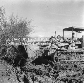
Negative - Photograph, J.A. McDonald, Kangaroo Ground-Queenstown Road, Aug. 1960
(Kangaroo Ground-St Andrews Road) “Rymers” Corner – shifting Hawthorn hedges on Tompkins property Council’s Drott 6 Woods Drott 9 August 1960 Showing method of lifting clumps of Hawthorn EDHS_05569-55 (EDHS_05577-3/4) and EDHS_05569-56 (EDHS_05577-5/6) - Hawthorn Hedges, Kangaroo Ground 50-50 ELTHAM, CUT THE HEDGES! While all of us are talking about the road toll, Eltham Council must have been in long recess. Around Kangaroo Ground are farmers’ hawthorn hedges shrouding dangerous corners on busy roads. If the council does not insist on their removal for a distance clear enough for safe driving, then it must be held culpable for the accidents that are bound to happen. – WAKE UP (Melbourne) ELTHAM, CUT THE HEDGES! 50-50 (1960, 6 January), The Sun (News clipping held in SEA_74-1_007) ‘BAD HEDGES’ WILL GO “We know there are some bad hedges on corners in the Kangaroo Ground area, but roadworks this year will eliminate them,” the Eltham Shire secretary, Mr Maxwell B. Watson, said yesterday. A reader in 50-50 yesterday complained of farmers’ hawthorn hedges obscuring drivers’ views at bad corners on busy roads in the Kangaroo Ground district. Mr Watson said the roadworks were deviations to remove the sharp turns, and the road would cut back into paddocks. The hedges would go at the same time. Meanwhile, the shire had power to require owners to cut back hedges, and this would be done if specific instances were reported and found justifiable. ‘BAD HEDGES’ WILL GO (1960, January 7), The Sun (News clipping held in SEA_74-1_007)Record of various Shire of Eltham infrastructure works undertaken during the period of 1952-1962 involving bridge and road reconstruction projects, sometimes with Eltham Shire Council Project Reference numbers quoted. It was during this period that a number of significant improvements were made to roads and new bridges constructed within the shire that remain in place as of present day (2022). In many situations, the photos provide a tangible visible record of infrastructure that existed throughout the early days of the Shire. The album was put together by or under the direction of the Shire Engineer, J.A. McDonald.infrastructure, shire of eltham, 1960-08, garden hill, kangaroo ground, kangaroo ground-queenstown road, kangaroo ground-st andrews road, rymers corner, bulldozer, drott -
 Eltham District Historical Society Inc
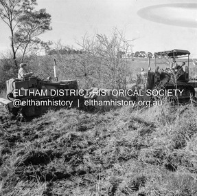
Negative - Photograph, J.A. McDonald, Kangaroo Ground-Queenstown Road, Aug. 1960
(Kangaroo Ground-St Andrews Road) “Rymers” Corner – shifting Hawthorn hedges on Tompkins property Council’s Drott 6 Woods Drott 9 August 1960 EDHS_05569-55 (EDHS_05577-3/4) and EDHS_05569-56 (EDHS_05577-5/6) - Hawthorn Hedges, Kangaroo Ground 50-50 ELTHAM, CUT THE HEDGES! While all of us are talking about the road toll, Eltham Council must have been in long recess. Around Kangaroo Ground are farmers’ hawthorn hedges shrouding dangerous corners on busy roads. If the council does not insist on their removal for a distance clear enough for safe driving, then it must be held culpable for the accidents that are bound to happen. – WAKE UP (Melbourne) ELTHAM, CUT THE HEDGES! 50-50 (1960, 6 January), The Sun (News clipping held in SEA_74-1_007) ‘BAD HEDGES’ WILL GO “We know there are some bad hedges on corners in the Kangaroo Ground area, but roadworks this year will eliminate them,” the Eltham Shire secretary, Mr Maxwell B. Watson, said yesterday. A reader in 50-50 yesterday complained of farmers’ hawthorn hedges obscuring drivers’ views at bad corners on busy roads in the Kangaroo Ground district. Mr Watson said the roadworks were deviations to remove the sharp turns, and the road would cut back into paddocks. The hedges would go at the same time. Meanwhile, the shire had power to require owners to cut back hedges, and this would be done if specific instances were reported and found justifiable. ‘BAD HEDGES’ WILL GO (1960, January 7), The Sun (News clipping held in SEA_74-1_007)Record of various Shire of Eltham infrastructure works undertaken during the period of 1952-1962 involving bridge and road reconstruction projects, sometimes with Eltham Shire Council Project Reference numbers quoted. It was during this period that a number of significant improvements were made to roads and new bridges constructed within the shire that remain in place as of present day (2022). In many situations, the photos provide a tangible visible record of infrastructure that existed throughout the early days of the Shire. The album was put together by or under the direction of the Shire Engineer, J.A. McDonald.infrastructure, shire of eltham, 1960-08, garden hill, kangaroo ground, kangaroo ground-queenstown road, kangaroo ground-st andrews road, rymers corner, bulldozer, drott -
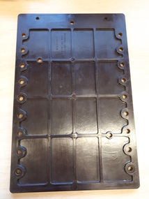
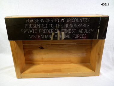 Bendigo Military Museum
Award - MEDAL SET WW2, Post 1945
Frederick Ernest ADDLEM Initially enlisted as No V122087 in the CMF (57/60th Bn) on 16.9.1941. His New Guinea service is listed as from 8.3.1943 to 11.8.1944. While there he transfers to the 2nd AIF as VX142253 on 9.6.1943. WIA on 18.3.1944, GSW to heel, returns to duty classed medically “A1” on 11.8.1944. Fred then embarks for Bougainville and this service is classed from 1.1.1945 to 15.2.1946. While in Bougainville he is hospitalised twice, once with Dysentry and then with Dermatitis. He is discharged from the 2nd AIF on 1.4.1946. Refer photo Cat No 937P..1) Box, wood, polished pine, Rectangular shape with brass plate on front, fold out stand at rear of box. .2) Medals, set of (6) mounted on perspex plate to hang in 432.1 1. 1939-45 Star. 2. Pacific Star. 3. Defence medal. 4. War Medal 1939-45. 5. Australian Service Medal 1939- 45. 6. Australian Service Medal 1945-75 with clasp "PNG"..1) On Brass plate : "For Services to your Country. Presented to Private Frederick Ernest Addlem Australian Imperial Forces" .2) "VX142253 - F.E. Addlem"metalcraft, inscriptions, numismatics - medals- military -
 Vision Australia
Equipment - Object, Hand frame with grid
Braille hand frames and styluses were the primary way to produce Braille for over a century. The stylus was used to make a separate indentation for each dot, and the hand frame to keep dots within the same cell. Braille rows are produced from right to left. The process was very time consuming. Volunteer transcribers for the library could take an average of ½ hour to produce one page of Braille using this method. For example: “Oliver Twist” required approximately 600 sheets equating to 300 hours of work! This wooden slate, which was used to make the system portable, served as a firm base needed to sustain puncture pressure. The frame can also be slotted into both sides of the slate, thereby ensuring that the lines of Braille were straight across the page. The metal clasp at the top of the frame held the wooden which kept paper from slipping.Brown plastic rectangular hand frame with holes evenly spaced on either long side. Hinged Braille metal guide with space for 2 rows of Braille, each 35 cells long. braille equipment, rnib -
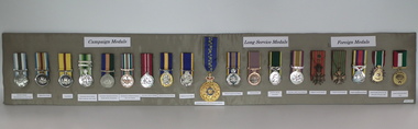 Bendigo Military Museum
Award - REPLICA AUSTRALIAN MILITARY AWARDS DISPLAY, Unknown
Displays Military awards that have been awarded to Australians since 1915 through to 2021. This includes awards from Foreign countries. The following group are all replica medals; Anniversary of National Service Medal 1951/1972, Australian Defence Medal 1945/open, Interfet Medal, Afghanistan Medal 2001-2021, Iraq Medal 2003, Australian Service medal with Cambodia and Sinai Clasps, Australian Operational Service Border Protection Medal, Reserve Forces Decoration Medal, Reserve Forces Medal, Companion of the Order of Australia (Military) Medal, Defence Long Service Medal, National Medal, Cadet Force Medal, Pingat Jasa Malaysia Medal, Efficiency Medal, The following may not be replicas; Croix de Guerrero (Circa WW1) Belgium, Croix de Guerrero (Circa WW1) French, Saudi Arabian Medal for the liberation of Kuwait, Kuwait Liberation Medal. 1 set of 21 Australian Military Awards dating from 1915 through to 2021 placed on a display board titled Board Number 4. There is an attached list identifying these awards. Each of the awards has it's appropriate title placed underneath the award.Right hand corner of the display board identifies from the " Bob English Collection".medals, awards, passchendaele barracks trust -
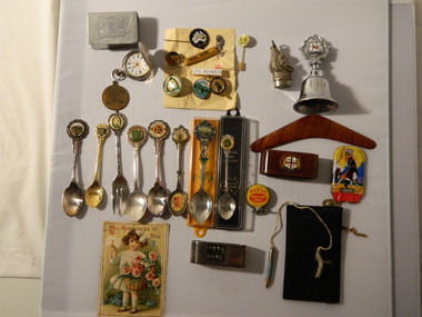 Kiewa Valley Historical Society
Collection - Personal - Dorothy Anderson
Organisations that Dorothy Anderson belonged to included many items to represent their clubs eg. badges, spoons, activities eg. crocheting. Dorothy lived in Tawonga indicating that those clubs existed in the town/area and were typical of regional areas of the time. These items were the property of Tawonga Citizen, Mrs Dorothy Anderson, who passed away in 2014, aged 90 years. She belonged to local clubs which existed in the area and acquired memorabilia belonging to those clubs and activities thus giving an insight into the life of women in regional towns. A personal collection of memorabilia stored in a black and cream solid but torn carry case with handle and broken clasp. Items include spoons, trophies, serviette rings name tags, member bar, pins, tea towel brooches, embroidered and crotchet items dance card pocket, birthday card, photos, pocket watch, bell, medals. Organisations: Tawonga Bowling club, CWA, Redcross, Doilies. Also refer to KVHS 0991 and KVHS 0992 Bogong Hotel On top of case written in blue biro: Laurie Anderson, Tawonga / via Wodonga / Phone No. 17tawonga., dorothy anderson, clubs, cwa, red cross, bowling club, memorabilia -
 Eltham District Historical Society Inc
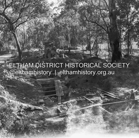
Negative - Photograph, J.A. McDonald, Eltham-Yarra Glen Road, Lower Plenty footbridge, Sep. 1955
The Eltham-Yarra Glen Road as designated originated at the Shire of Eltham boundary at the Plenty River. West of the river the road was known as the Heidelberg-Eltham Road. The section from the Plenty River is now known as Lower Plenty Road which becomes Main Road. The footbridge no longer exists but was originally sited to the south, adjacent to the old Lower Plenty Bridge, now part of the Plenty River Trail. Record of various Shire of Eltham infrastructure works undertaken during the period of 1952-1962 involving bridge and road reconstruction projects, sometimes with Eltham Shire Council Project Reference numbers quoted. It was during this period that a number of significant improvements were made to roads and new bridges constructed within the shire that remain in place as of present day (2022). In many situations, the photos provide a tangible visible record of infrastructure that existed throughout the early days of the Shire. The album was put together by or under the direction of the Shire Engineer, J.A. McDonald.1955-09, eltham-yarra glen road, lower plenty footbridge, lower plenty, lower plenty bridge, lower plenty road, main road, plenty river trail, bridge construction, infrastructure, shire of eltham -
 Eltham District Historical Society Inc
Negative - Photograph, J.A. McDonald, Eltham-Yarra Glen Road, Lower Plenty footbridge, Sep. 1955
Tony Carberry and J. Jolly The Eltham-Yarra Glen Road as designated originated at the Shire of Eltham boundary at the Plenty River. West of the river the road was known as the Heidelberg-Eltham Road. The section from the Plenty River is now known as Lower Plenty Road which becomes Main Road. The footbridge no longer exists but was originally sited to the south, adjacent to the old Lower Plenty Bridge, now part of the Plenty River Trail. Record of various Shire of Eltham infrastructure works undertaken during the period of 1952-1962 involving bridge and road reconstruction projects, sometimes with Eltham Shire Council Project Reference numbers quoted. It was during this period that a number of significant improvements were made to roads and new bridges constructed within the shire that remain in place as of present day (2022). In many situations, the photos provide a tangible visible record of infrastructure that existed throughout the early days of the Shire. The album was put together by or under the direction of the Shire Engineer, J.A. McDonald.1955-09, eltham-yarra glen road, lower plenty footbridge, j. jolly, lower plenty, lower plenty bridge, lower plenty road, main road, plenty river trail, tony carberry, bridge construction, infrastructure, shire of eltham -
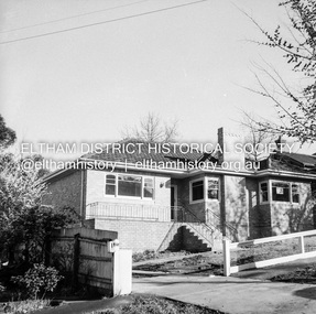 Eltham District Historical Society Inc
Negative - Photograph, J.A. McDonald, Newly built home, Sep. 1955
Street and location unidentified, possibly not Eltham though next immediate frame is Pryor Street and sun position appears to be similar indicating street (ealrly to mid afternoon) indicating street runs east west direction and camera view is to the south. Streets in Eltham are all even numbered on the south sideRecord of various Shire of Eltham infrastructure works undertaken during the period of 1952-1962 involving bridge and road reconstruction projects, sometimes with Eltham Shire Council Project Reference numbers quoted. It was during this period that a number of significant improvements were made to roads and new bridges constructed within the shire that remain in place as of present day (2022). In many situations, the photos provide a tangible visible record of infrastructure that existed throughout the early days of the Shire. The album was put together by or under the direction of the Shire Engineer, J.A. McDonald.1955-09, houses, shire of eltham -
 Eltham District Historical Society Inc
Negative - Photograph, J.A. McDonald, Eltham, Pryor Street, Sep. 1955
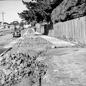
Construction of new concrete kerbing and footpath in Pryor Street, Eltham 18” tray and AG backing(?)Record of various Shire of Eltham infrastructure works undertaken during the period of 1952-1962 involving bridge and road reconstruction projects, sometimes with Eltham Shire Council Project Reference numbers quoted. It was during this period that a number of significant improvements were made to roads and new bridges constructed within the shire that remain in place as of present day (2022). In many situations, the photos provide a tangible visible record of infrastructure that existed throughout the early days of the Shire. The album was put together by or under the direction of the Shire Engineer, J.A. McDonald.1955-09, footpaths and gutters, pryor street, infrastructure, shire of eltham -
 Eltham District Historical Society Inc
Negative - Photograph, J.A. McDonald, Eltham, Pryor Street, Sep. 1955
Construction of new concrete kerbing and footpath in Pryor Street, Eltham The truck on the left of the road is parked ouside the Eltham Police Station at No. 23. On the right is the present-day Woolworths carparkRecord of various Shire of Eltham infrastructure works undertaken during the period of 1952-1962 involving bridge and road reconstruction projects, sometimes with Eltham Shire Council Project Reference numbers quoted. It was during this period that a number of significant improvements were made to roads and new bridges constructed within the shire that remain in place as of present day (2022). In many situations, the photos provide a tangible visible record of infrastructure that existed throughout the early days of the Shire. The album was put together by or under the direction of the Shire Engineer, J.A. McDonald.1955-09, footpaths and gutters, pryor street, eltham police station, infrastructure, shire of eltham -
 Eltham District Historical Society Inc
Negative - Photograph, J.A. McDonald, Pinnacle Lane, Steels Creek, Sep. 1955
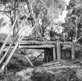
The old bridge looking downstream Record of various Shire of Eltham infrastructure works undertaken during the period of 1952-1962 involving bridge and road reconstruction projects, sometimes with Eltham Shire Council Project Reference numbers quoted. It was during this period that a number of significant improvements were made to roads and new bridges constructed within the shire that remain in place as of present day (2022). In many situations, the photos provide a tangible visible record of infrastructure that existed throughout the early days of the Shire. The album was put together by or under the direction of the Shire Engineer, J.A. McDonald.1955-09, pinnacle lane, steels creek, bridge construction, infrastructure, shire of eltham -
 Eltham District Historical Society Inc
Negative - Photograph, J.A. McDonald, Pinnacle Lane, Steels Creek, Sep. 1955
The old bridge looking eastwardsRecord of various Shire of Eltham infrastructure works undertaken during the period of 1952-1962 involving bridge and road reconstruction projects, sometimes with Eltham Shire Council Project Reference numbers quoted. It was during this period that a number of significant improvements were made to roads and new bridges constructed within the shire that remain in place as of present day (2022). In many situations, the photos provide a tangible visible record of infrastructure that existed throughout the early days of the Shire. The album was put together by or under the direction of the Shire Engineer, J.A. McDonald.1955-09, pinnacle lane, steels creek, bridge construction, infrastructure, shire of eltham