Showing 995 items matching "happy"
-
 Ringwood and District Historical Society
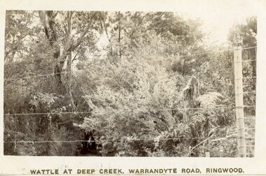
Postcard - Photograph/Postcard, Wattle at Deep Creek, Warrandyte Road, Ringwood. Handwritten Date 23/12/1915
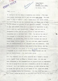
Postcard with Handwritten letter on reverse22/12/15, Wonga Park, Ringwood My Dear Niece and Nephews I have just received your lovely preasant we all think it is just lovely and we all wish you all a very Happy New Year and a Merry Xmas. You will see I have put the cart before the horse but the three children is here and makeing a terrible noise. Bella has got a house in Mullum Rd near the station we have been all this time getting her settled and we are all going to her Place Xmas day and to Tunstall Boxing Day as we do not feel up to having them all here this year. My son Eddy got married a fortnight ago but he lives in Ringwood. will be pleased to see you soon, loving Aunt and ?? -
 Robin Boyd Foundation
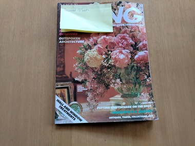
Magazine, Vogue Living, "All the Good Things of Life" Vogue Living Australia Vol. XX, No. 2, Whole No. 109, 1986
Softcover MagazineNote on the front cover with name "Raymond McGrath". Postcard found on page 108 from 6th May 1987 at Durras NSW. "Dear Trish, We are on our third day at Durras and having a wonderfully healthy holiday going for long beach walks and getting quite exhausted. Yesterday the more hardy of us (Ben, Amy & me) even swam. Just prior to our swim four dolphins had been frolicking in the bay where we were picnicking. Ben, Amy and Rupert are anxious to do some fishing so we are off to buy some bait and post this card in Batemans Bay some 20km south. Happy Mother's Day for Sunday. Love from us all, Penleigh." The postcard sent to Mrs John Davies and features the SS Merimbula approaching home wharf, photo credit unknown.walsh st library -
 Monbulk Historical Society
Ben Simcox
Bennie Simcox first came to the Monbulk area about 1860, following the first important gold discovery at the end of 1858. As the gold rush was short lived Simcox returned to Collingwood but later came back to Monbulk, built himself a hut to live in and become its first known permanent resident. The hut was burnt in the 1913 fires. Monbulk was thrown open to selection in 1894, and that's when the first farmers including Bennie Simcox went into Monbulk. It was a big, timbered country in those days. Once Ben had cleared some of his land he started to grow raspberries on it. He would be up before daylight ready to start picking. Ben also picked for a local family, the Camms to help make ends meet. When Ben Simcox was virtually at the retired stage, he wanted to develop his bit of the gully as a tourist attraction, As his nephew Fred Gay who owned the 10 acres below Ben wanted to farm, he was happy to swap his treed block with Ben. At a time when most settlers were clearing their properties, Ben Simcox, by contrast, cultivated the native plants and planted most of the large trees seen on the property today. And so Nathania Springs was developed as a tourist resort, and a mini-botanical garden. He diverted the natural water supply to form ornamental garden pools stocked with trout and tame native black fish. There were many visitors came to the Dandenongs, Some arriving in motor cars others in converted furniture vans lined with seats or charabancs with the long extended chassis and the open canvas roofs. Identities such as Billy Hughes, Madame Melba would often come to look through Nathania Springs. Bennie sold Nathania Springs to Councillor Ferdinand Thomas Le Juge, a boarding house proprietor and later the town baker in 1909 then in about 1921 Ben’s nephew Fred and his wife and family continued to open Nathania Springs to the public. It was not unusual in around 1924-25 for up to a thousand people a day to arrive at Nathania Springs to go through the gardens. At sixpence a time, that was a lot of money in those days. This photo is part of a collection of historic and social significance of the early settlement of Monbulk. Copies of photographs can be purchased from the Monbulk Historical Society.simcox, nathania springs, monbulk, 1860, berries -
 Melton City Libraries
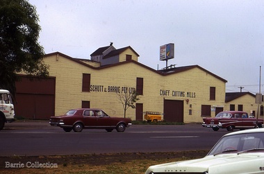
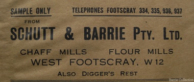
Photograph, Schutt and Barrie Pty Ltd Chaff Cutting Mills, Unknown
Mary nee Barrie Robinson (1907 –1999) writes c1980 about her father Charles Ernest Barrie of Darlingsford Melton (1871 – 1931) Extract copied from her handwritten story - My father was born in Ballarat in 1871. … commenced his working life with a team of bullocks and a chaffcutter in the St Arnaud district, a work the he became most success at and would continue in to the end of his life. He eventually became the owner of a chaff mill at Melton station with an access line to the railway. [1900] The Schutt & Barrie partnership Dad later became involved in a Chaff mill at West Footscray run by John Ralph Schutt who when he met Dad was a very sick man and had begged Dad to come into the business and help him. That began a very happy association, the business was put on its feet. An empty quarry across Geelong Road opposite the mill was purchased, the chaffcutters were set up in the quarry and that was the start of a very busy and prosperous period. A branch line was run into the mill. Dad spent some afternoons at the mill going by train, and spending some hours there at night, at the same time running the farm with full time help. Two full 8 horse teams were used to work the land, which meant early rising for the horses to be fed and harnessed ready for the men to commence the days work. Charlie Lowe and Murdock Davey were two of the men who worked for Dad in those years. The firm purchased a mill at Parwan and Dad spent a lot of time and energy getting it running to their satisfaction. Monday was the day he spent time there also round the district of Parwan and Balliang. He came to know many of the their names were well known in our household for many years. [1920] Later a flour mill was built beside the Chaff mill at West Footscray but it never thrived like the mill. The chaff mill had many loyal and good men employed there and there was never any trouble between men and management. Willie Walters and Miss Renyolds were some I remember, other names me, Joyce would be able to name them. [Sister of Mary born 1920] Schutt and Barrie Pty Ltd Chaff Cutting Mills Melton South sitelocal architecture, local identities, agriculture -
 Bendigo Historical Society Inc.
Photograph - HILDA HILL COLLECTION: BLACK AND WHITE PHOTOS
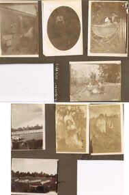
Hilda Hill Collection. Combination Sepia & Black & White Photos Double Sided Card Total of 8 depicting family life towards the end of the First World War in 1918 up until July 1924. A comparison exists between life at 'The Ranch' ? In Eppalock in 1918 versus life at 'The Ranch' in 1924. lady standing at the front of the house with left arm raised to shade her eyes dressed in a dark coloured dress, light coloured cover on chair in background at 'the Ranch' June 1918. Oval black and white photo of Doreen at Durvol, dressed in black skirt and white shirt with black school? Tie June 1918. Proud parents with baby sitting in pram, both p[parents are wearing dark coloured hats dark clothing and white shirts, pram is boat style body with large rear wheels and smaller front wheels. White picket fence in background, May 1918. Also on this page is a reference to 'The Ranch' July 1924 in white, but no photo. Claire and Doreen sitting on lawn area, small garden to left, row of decorative plants in semi circle, dead tree centre background and other trees to left and right background, S.H.L.C. 24 Sept 1918. Boys' Flag Drill - repatriation Upper Reserve 19 October 1918. Group of people, all but one females, all in white at No. 7 reservoir happy 9 January 1919. Al and Marie sitting, Al in all white and hatless, Marie in white blouse and black waistcoat with black tie, foreground shows large rocks, background has trees in distance, No.7 reservoir 9 January 1919. Childrens folk dance at Upper Reserve, All children dressed in white, large round hat in foreground, and suited man in hat walking past 19 October 10918.Hilda Hill Personal Collectionaustralia, history, post war life -
 Flagstaff Hill Maritime Museum and Village
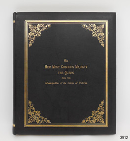
Book - Album, Sands & McDougall Limited, To Her Most Gracious Majesty the Queen from the Municipalities of the Colony of Victoiia, 1897
This book is a black and white facsimile of the coloured, commemorate album presented to Queen Victoria on her Diamond Jubilee in June, 1897, celebrating the 60th Anniversary of her reign on the British throne. The Municipalities also received original copies, each numbered as limited editions. The first two pages of the album are an address to Queen Victoria from the Municipalities of the Colony of Victoria, Australia, written in fancy Old English calligraphy. The remaining twenty-three pages display images representing each of the 208 municipalities as in 1897 and include a medallion of their Coat of Arms and statistics such as population, size and valuation, signatures of the Shire Presidents and Secretaries. The album’s publisher, Sands & Mc Dougall Limited, was first established in Sydney. This book was published by the Melbourne Branch. Local areas mentioned in the album include – Town of Warrnambool, page 5, Borough of Portland, page 7 Borough of Port Fairy, page 9 Borough of Koroit, page 9 Shire of Belfast, page 10 Shire of Portland, page 10 Shire of Warrnambool, page 10 Shire of Mortlake, page 12 TRANSCRIPTION OF THE ADDRESS TO QUEEN VICTORIA – “May it please Your Majesty, We Your Majesty’s most dutiful and loyal subjects, the representatives of the Municipal Government of the entire Colony of Victoria, humbly approach Your Majesty with earnest assurances of our attachment and devotion to Your Majesty’s Throne and person. We beg to offer to Your Majesty respectful and heartfelt congratulations on completion of the 60th Year of Your Majesty’s reign and to express our grateful recognition of the beneficent influence exercised by You as our Queen during that long period. We are proud of the honour that united, we form the Colony which bears Your Majesty’s name and the unity of this, our expression of congratulation and thankfulness, is truly typical of the united love of the people of this Colony for You as our Queen and for our Nation. With devout thankfulness to our Almighty God for wisdom, guidance and strength vouchsafed in You as our Sovereign, and for unexampled blessings bestowed upon us Your people, we offer earnest prayer that the continuance of Your Majesty’s reign may be a season of peace amongst the Nations of the World and of closer and still happier kinship between the many and wide unretruding sections of our Empire. As witness, the Corporate Seals of the 208 Municipalities of the Colony of Victoria. This 21st day of June 1897.”This facsimile album is significant for its association with early Australian history, the influence of the British Monarch over its Colony, and the establishment, growth and extent of the Colony of Victoria. The album gives a summary of a set year and the statistics of each Municipality. This gives added significance to the history of South-West Victoria, including Warrnambool, allowing a comparison of then and now. The album's inclusion of the Address to Your Majesty shows the respect of the people of Victoria towards the British Monarchy.Book, hard cover, bound in black leather with gold embossed title and border on the front cover, gold lines top and bottom of spine and gilt edged pages. Inside covers are lined in white embossed fabric. Twenty-five pages are all thick, cream coloured card with a rectangular border in the centre of each page. Attached inside the boarders are black and white copies of illustrations and text. A green printed label is attached inside the back cover.“SANDS & Mc DOUGALL LIMITEDN/Manufacturers/MELBOURNE”flagstaff hil, warrnambool, flagstaff hill maritime museum, maritime museum, shipwreck coast, flagstaff hill maritime village, great ocean road, queen victoria, diamond jubilee, 60th anniversary, album, municipalities of victoria, colony of victoria, 1897 statistics of victoria, sands & mcdougal, facsimile album, australian history, victorian history, historical document, address to your majesty, address to queen victoria, victoria queen of britain, queen of the united kingdom, 60th anniversary of reign, 1819-1901, jubilee 1897, 208 municipalities, seals of victoria, statistics in victoria 1897, presentation album, british monarchy -
 Melton City Libraries
Document, 'Schutt and Barrie Flour Mill envelope, Unknown
SUMMARY - Schutt & Barrie Chaff Mills Partnership West Footscray, Parwan and Diggers Rest. Mary nee Barrie Robinson (1907 –1999) writes c1980 about her father Charles Ernest Barrie of Darlingsford Melton (1871 – 1931) Extract copied from her handwritten story - My father was born in Ballarat in 1871. … commenced his working life with a team of bullocks and a chaffcutter in the St Arnaud district, a work the he became most success at and would continue in to the end of his life. He eventually became the owner of a chaff mill at Melton station with an access line to the railway. [1900] The Schutt & Barrie partnership ….Dad later became involved in a Chaff mill at West Footscray run by John Ralph Schutt who when he met Dad was a very sick man and had begged Dad to come into the business and help him. That began a very happy association, the business was put on its feet. An empty quarry across Geelong Road opposite the mill was purchased, the chaffcutters were set up in the quarry and that was the start of a very busy and prosperous period. A branch line was run into the mill. Dad spent some afternoons at the mill going by train, and spending some hours there at night, at the same time running the farm with full time help. Two full 8 horse teams were used to work the land, which meant early rising for the horses to be fed and harnessed ready for the men to commence the days work. Charlie Lowe and Murdock Davey were two of the men who worked for Dad in those years. The firm purchased a mill at Parwan and Dad spent a lot of time and energy getting it running to their satisfaction. Monday was the day he spent time there also round the district of Parwan and Balliang. He came to know many of the their names were well known in our household for many years. [1920] Later a flour mill was built beside the Chaff mill at West Footscray but it never thrived like the mill. The chaff mill had many loyal and good men employed there and there was never any trouble between men and management. Willie Walters and Miss Renyolds were some I remember, other names me, Joyce would be able to name them. [Sister of Mary born 1920] Sample envelope from the businesslocal identities -
 Eltham District Historical Society Inc
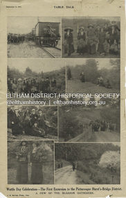
Magazine Article, J.E. Barnes, Wattle Day Celebration - The First Excursion to the Picturesque Hurst’s-Bridge District; A few of the blossom gatherers; Table Talk, September 5, p23, 1912
The September 5, 1912 issue of Table Talk celebrated "Wattle Day" where new plantings are made of the national flower and featured images from both Melbourne as well as the first excursion to Hurstbridge. Those from Hurstbridge were photographed by notable WW1 photographer, J.E. Barnes. Also digitised and accessible via National Library of Australia Trove website - (1912, September 5). Table Talk (Melbourne, Vic. : 1885 - 1939), p. 23. Retrieved July 28, 2024, from http://nla.gov.au/nla.news-page17413107 See an article on reflections about Wattle Day on page 29 - SOME REFLECTIONS UPON WATTLE DAY. (1912, September 5). Table Talk (Melbourne, Vic. : 1885 - 1939), p. 29. Retrieved July 28, 2024, from http://nla.gov.au/nla.news-article146180986 The inaugural Hurstbridge Wattle Day Festival was held Saturday, September 1, 1912 when a specially commissioned train brought 1,000 visitors to the district to enjoy the splendour of the wattle in bloom. “Melbourne’s first “Wattle Day” Campaign, the day when Australia’s national flower was to be all pervading in the streets of the metropolis, and sold in sprigs and bunches by hundred of lady volunteers, for purposes of charity, was not blessed with happy climatic conditions on Monday [2 Sep 1912]” - WATTLE DAY. (1912, September 7). Leader (Melbourne, Vic. : 1862 - 1918, 1935), p. 39. Retrieved July 28, 2024, from http://nla.gov.au/nla.news-article198116738 “In connection with Wattle Day celebrations a special train conveyed a thousand people to Hurst's-Bridge last Saturday afternoon [1 Sep 1912]. Lengthy reports of the excursion appeared in the daily papers last Monday. - WATTLE DAY. (1912, September 6). Evelyn Observer and Bourke East Record (Vic. : 1902 - 1917), p. 2 (MORNING.). Retrieved July 28, 2024, from http://nla.gov.au/nla.news-article60656027 See a review of the excursion to Hurst’s-Bridge - HURST'S-BRIDGE EXCURSION. (1912, September 2). The Age (Melbourne, Vic. : 1854 - 1954), p. 9. Retrieved July 28, 2024, from http://nla.gov.au/nla.news-article196255907 The excursion to Hurst’s-Bridge was considered such a success that the Railway department arranged to run another special train to the station on Saturday, October 5, 1912 - HURST'S-BRIDGE EXCURSION. (1912, October 2). The Age (Melbourne, Vic. : 1854 - 1954), p. 10. Retrieved July 28, 2024, from http://nla.gov.au/nla.news-article203325447Inaugural Hurstbridge Wattle Day Festival held 1 September 1912d3-class steam locomotive, hurstbridge wattle festival, special train, tait train, tourism, wattle day campaign, wattle day festival, david smyth collection -
 Flagstaff Hill Maritime Museum and Village
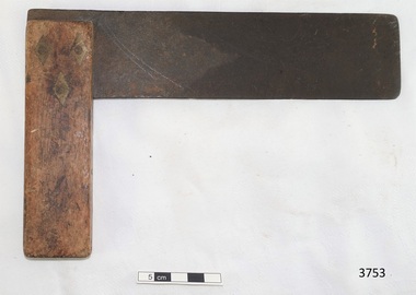
Instrument - Set Square, 1930-1955's
This set square was used in the planning and making of components for the ship model Sovereign of the Seas. It is part of a collection of objects used by Jim Williams, maker of fine ship models from about 1930-1955. Most of the components for the models, as well as many of the tools, were handmade by Jim Williams. Jim’s family has donated the ship model “Sovereign of the Seas” and many tools, accessories and documents used in the making of this and other ship models have been donated to Flagstaff Hill Maritime Village. Ship model of HMS Sovereign of the Seas, scale model of 17th Century English war ship, was handmade and carved from plans, enclosed in airtight glass case. All components of that model, including even the smallest pulleys, were hand crafted using tools designed and made by Jim. Outstanding details include functional rigging and moving cannons. Please see our record 3732 of the mode Sovereign of the Seas for further details of the ship and the maker. James Bernard Williams was known as Jim Williams, born 1888 at The Forth and died 1959 in Warrnambool. He was a passionate ship model builder. Jim left school at the age of 14 years to work at the Don Store in Ulverstone, Tasmania. He played piano at the silent pictures. He enlisted and fought in France along with his two brothers and was wounded there. On return to Tasmania he found it difficult to get employment. He moved to Warrnambool and worked in the menswear department at Cramond & Dickson clothing store, corner of Timor and Liebig streets, until the Depression, when he lost his job. After some time unemployed and working part time until 1932, Jim was employed at Fletcher Jones Menswear in Warrnambool. In 1957 Fletcher Jones invited Jim to write out a list of the most interesting details of the ship model Sovereign of the Seas, with the view of displaying the model and the information for a short time in the factory and then move it to the display window of the Fletcher Jones shop in Warrnambool. Jim worked there for 27 years until just before he died in 1959. His Retirement Speech letter and a Staff Photo from Fletcher Jones are included with the donation. ABOUT JIM’S MODEL MAKING For many years Jim worked on his model ships, including The Endeavour and The Sovereign of the Seas. He had a table set up in a bay window and worked on them on and off using a jeweller's eye glass on the finer pieces. He was a real perfectionist and would re-carve pieces many times until he was happy with the results. This set square is connected with the hobby and skill of ship model making that has been crafted as a leisure activity for many generations. The hobby is often chosen by serving and retired mariners who appreciate the connection with maritime history. This set square was used by local Warrnambool man, Jim Williams, who was employed at Cramond and Dickson clothing store, and then at Fletcher Jones menswear for 27 years. It was used in making components for the model of the historic ship, the Sovereign of the Seas. The Sovereign of the Seas was a historic 17th century English war ship with important maritime heritage. Set square; thin, flat metal blade with rounded corners set at a right-angle into timber stock using three rivets, each with a diamond shaped surround. There is a remnant of red paint on the timber and signs that the set square has been well used. This set square is part of a collection of tools and accessories once used by Jim Williams, maker of a series of ship models 1930-1955 including “HMS Sovereign of the Seas”. flagstaff hill, warrnambool, flagstaff hill maritime museum, maritime museum, shipwreck coast, flagstaff hill maritime village, great ocean road, ship model sovereign of the seas, jim williams, james bernard williams, ship model hobby, ship model tools, ship model making equipment, ship model making accessories, measuring instrument, technical drawing instrument, set square, carpenter’s square, drawing instrument, drawing tool, technical drawing tool, sovereign of the sea, ship model, hobby, ship model tool, english war ship -
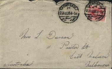 Mission to Seafarers Victoria
Letter - Correspondence, Letter to Lillie from Howard, 29 August 1925
The "letters to Lillie" show the international nature of the Mission to Seafarers. They are an important display of the handwriting style of the time, revealing courting attempts and give us an insight into life in 1925. Page 1 S/S City of Norwich Port Said My Dear Old Lillie, Well, I never got so much of a shock in my life, when your postcard turned up 2 days before my birthday, wishing me many happy returns, for which I thank you sincerely, and am sorry to say I had forgotten yours, or being very quiet about your various qualities, you would not tell me. Well to get on with the news, the next day I had a telegram to report at the Line head office, on the 15th Aug. early, imagine how I swore, as a little do was to [be] held at night, they immediately shored me on this ship S/S City of Norwich to go to Port Said, then join the City of Corinth bound for Boston & New-York so I may come out to “little Aussie” again from there with a little luck, any way we ought to be in New-York about the 19th Sept to stay a month, I will write you more in detail from there, if you feel inclined and have forgiven me for being so long about answering your last letter, could you write to S/S City of Corinth, C/o Norton Lilly & Co, New-York. U.S.A. I would jump like L”l Page 2 how is the cow milking going on, but still that joke is as unfair as the small joke about my age now, both afflictions being cured by now I hope. Well really I am no letter writer and can find very little to interest you on paper Lillie, and my photo, I hate being taken as much as you, but will do my best, if you can wait a little please, hoping you are getting one that awfully exciting week with the mission as you call it. You must be A.1 actresses to amuse such a motley crew. Hoping you are all well at home, give Mr & Mrs Duncan my kind regards, sending my best love to you dear. Hoping you will recognize me if I can come along. with tons of love, Howard. P.S. I hope to be a little more sophisticated when I come next time [-] you may be able to tell me. Lillie Duncan was a member of the Harbour Lights Guild and this letter forms part of a collection of letters sent to her by different seafarers.Letter addressed to Miss L Duncan, 11 Paxton St, East Malvern, Melbourne, Australia from Howard in three parts: Part 1.1 (0007.1) Envelope Part 1.2 (0007.2) First page of letter Part 1.3 (0007.3) Second page of letter The pages, as is the envelope, are a creamy yellow colour with black cursive writing on one side of the page. Page 1 of the letter begins with the salutation "My Dear Old Lillie...". Page 2 of the letter concludes with "...you may be able to tell me".The envelope is torn across the top for access to its contents. It has two stamps on the top right hand corner both with the text "Port Said 23AU25.4.5P".lillie duncan, howard, port said, lhlg, ss city of norwich -
 City of Moorabbin Historical Society (Operating the Box Cottage Museum)
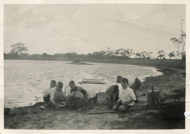
Photograph, Black & White, Boys fishing for Yabbies Methodist Childrens' Home Cheltenham 1935, 1935
1892-1953 The Methodist Children's Home in Cheltenham was founded c1880 to provide housing for neglected children from the inner city. The Founders aimed to provide regular nourishment, a stable environment and integrate the children into the local community thereby improving their education and lives. However new settlers to Cheltenham area who were seeking a healthier and more respectable lifestyle for their families were not happy to share Church and School with the Home's Children. 1911 school parents committee moved to exclude the Home's Children but this was countered by the Home's Committee who defeated the motion 60 to 8. 1915 Dr Scantlebury was pressured by school parents into ordering the confinement/ isolation of all Homes Children if an infectious disease was contracted by a child. This resulted in the Homes Children missing school for months so an application was made to the Victorian Education Dept. for e School to be set up at the Home. However funds were short due to WW1. In 1917 John Livingston, former Homes child who had become successful, bequeathed his estate to the Home and the Vic.Education Dept agreed to a school at the Home. The Influenza epidemic 1919 saw the children quarantined for 4 months as a precaution at the Home. When Flu actually struck, a further 5 months isolation was ordered. July 1920 their own school was on site and continuity of education could proceed , however it reinforced the isolation of the institution contrary to the Founders vision of integration.. 1925 the Danks family funded a Domestic Economy Class for girls, but not until 1936 could the children attend the local High School so that they could pursue office work, apprenticeships, commercial college courses. 1947 a benefactor donated £5,000 to pay fees for school, university or apprenticeship in Arts & Cultural subjects. Some of the children were able to join the local society as Methodist minister, accountant, nurses, farmers, secretaries, trademen whilst others were unable to adjust as crime and misfortune ensued. 1939 some past residents began a group called Living Stones Union that they circulated to the others giving news and a sense of family connectedness among themselves. ( Rev. N. Marshall, KCC Local History , H. Stanley 2005) 1950's saw a new direction for the support of children and families in poor and difficult situations . The new Burwood Homes Facility opened in 1951 and children were transferred from Cheltenham in 1952. The land was sold to the St John of God, Catholic Order in1953 who maintained an orphanage until Myer Pty Ltd bought the site in 1967 and constructed the Southland Shopping Centre1892 -1953 The Methodist Children's Home Cheltenham was founded to provide safe accommodation and education for neglected children from the Melbourne inner city slums. Black & White photograph of boys fishing for yabbies from the lake behind the 'Methodist Homes for Children' Cheltenham pdf of Appeal for the establishment of an Infant Asylum 1877methodist childrens home cheltenham 1892- 1953, st john of god home cheltenham 1953-1967, scantlebury dr john city of moorabbin, county of bourke, moorabbin roads board, parish of moorabbin, shire of moorabbin, henry dendy's special survey 1841, were j.b.; bent thomas, o'shannassy john, king richard, charman stephen, highett william, ormond francis, maynard dennis, cheltenham state school no.84, methodist chapel cheltenham, methodist school cheltenham, beaumaris west state school, meeres frederick, meeres walter, education, early settlers, -
 Melbourne Legacy
Document - Eulogy, Legatee Francis John Doolan
Information on the life of Legatee Frank Doolan from a eulogy in 1988. Legatee Doolan was a very active Legatee, starting within the first year of Legacy when he was nominated by Bill Laver and Charles Copp in 1924. While he never sought 'office but he was always there - in the background - able and willing to actively serve'. In World War 1 he enlisted in November 1917 and served with 1st Division Signal Company and in France. After Armistice he attended a course for young AIF surveyors at the British Ordnance Headquarters at South Hampton designed to bring skills back to Australia. Famously it was Frank that proposed that the spirit of Legacy is service to the widows and children. "Here it received its soul. The thoughts transmitted to the Board by this quiet man." He was Legacy's link to the Big Brother movement that was sponsoring bereft children in England to be sympathetically housed in Australia. He was a foundation member of the the first boys' gymnasium class and of the literary and debating class. He worked with the Intermediate Legacy Club for it's entirety He was part of the Legacy team who worked enthusiastically for the establishment of the Shrine. It was his technical skill as a surveyor that enabled the ray of light to shine on the Stone of Remembrance at 11 am on 11th November. Also to solve the complication of daylight saving in 1976 by positioning two mirrors. For this he was awarded the British Empire Medal. Born in 1896 at Armadale he was educated in Ballarat and South Melbourne. He obtained his qualification as a licensed surveyor at the Working Men's College (now RMIT) in 1919 on returning from war. He was partner in 'Doolan and Goodchild' through the hardships of the Great Depression. Then joined firm of Mendell, Gillespie and Charleman - being supported by Legatee Jim Gillespie. He went on to Lecturer of surveying at the Working Men's College from 1926 to 1938. Then he was assisted by Legatee Alan Murray to a position with the Valuers Section of the Department of Interior. In 1953 he was promoted to be Chief Property Officer for Victoria retiring in 1961. The page from the Bulletin from 18 August 1988 shows the names of many donors that had paid tribute to Frank. A few sentiments were included by some: 'A quiet, loveable and outstanding Legatee.' 'He was my friend, guide and mentor during the 14 happy years I spent in Legacy.' The information was part of an album of past presidents from 1965 to 1989. The folder included biographical details and obituaries, eulogies and death notices of prominent Legatees. The items have been catalogued separately.Part of the collection of material held by Melbourne Legacy on Legatee Frank Doolan a prominent member of Legacy. The information was collected to record the lives of prominent legatees in a folder.Typed A4 document x 2 pages of the life of Legatee Frank Doolan and one page from the Bulletin with donations received in his memory.eulogy, frank doolan, ray of light, shrine of remembrance, ilc, donations -
 Glen Eira Historical Society
Article - Hopetoun Gardens
This file contains eleven items about these Gardens: 1/Handwritten note from Pam Harrison of Monash University dated 15/06/2005, stating that she is sending the Glen Eira Historical a collection of items from her aunt, whose husband worked for Caulfield Council. Stapled together with a typed acknowledgment from Hazel Ford, Hon. Secretary of the Society dated 15/07/2005. 2/Typed letter from Walter A. Coxen of Queenscliff to (unnamed) Mayor of Caulfield, dated 14/04/1910, stating that he encloses information about the two eighty pound rifled muzzle loading guns now at Hopetoun Gardens, with more recently typed shot description of “The Cannon of Hopetoun Gardens.” Also included is a typed page dated 14/04/1910, signed by Mr Coxen on “Particulars of the two eighty-PR guns presented to the Caulfield Town Council”. 3/Two undated black and white photographs showing garden beds at Hopetoun Gardens. 4/Typed letter from Lt.-Col M.P.J. O’Brien, President, Fort Queenscliff Museum, dated 05/09/1984, to R-Ballantine, Hon. Secretary of the Caulfield Historical Society, stating that he would be happy to assist in tracing the history of the cannons in Hopetoun Gardens. 5/Photographs of the cannon at Hopetoun Gardens. Four are recent colour photographs, one dated 06/1981. One is a black and white photograph, undated (mid-1930s?), with a man sitting on the cannon. One is a black and white photocopy of a photograph of the cannon, with three children, possibly from 1910. 6/Two colour photographs dated 15/05/2009, of the bandstand at Railway Reserve, which is to be moved to a new park in Glen Huntly Road. 7/Two colour photographs of the bandstand and playground equipment at Hopetoun Gardens, dated by hand on “c. 2000” 8/Printed four page booklet (two copies), no date (c. 2000?) of “Your Guide to Hopetoun Gardens – Interpretative Tree Walk”, printed by the Glen Eira City Council Recreation Services. 9/One colour negative (two copies of each) of swimming at Hopetoun Gardens, no date 10/Printed emails of correspondence dated from 26/08/2012 to 02/10/2012, to and from the Glen Eira historical Society, about the cannons at Hopetoun Gardens. 11/Article from Glen Eira News dated March/April 2013 about the history of the cannons with a coloured photograph.hopetoun gardens, harrison pam, ford hazel, coxen walter adam, cannons, parks, fort queenscliff, elsternwick, bandstands, glen eira recreation services, trees, triarico elizabeth, dunbar margaret, rogers john (fleet engineer) -
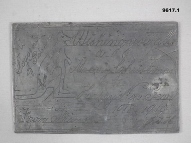
 4th/19th Prince of Wales's Light Horse Regiment Unit History Room
Card - Christmas Card, 1915 (exact)
Service of Frank Phillips Prior to the commencement of World War I, Frank Phillips served in the Minyip Troop of the Light Horse militia. His civilian occupation was that of clerk. On 22 August 1914 he enlisted in C Squadron 4th Light Horse Regiment. The 4th Light Horse Regiment embarked on the troop ship “Wiltshire “ for training at Mena Camp, in Egypt. During May 1915 the Regiment was deployed to the Gallipoli campaign in a dismounted role. After seven months, the Gallipoli campaigned was abandoned and the troops withdrawn. On return to Egypt the 4th Light Horse Regiment divided with one component deployed to Palestine and the other to the Western Front. Frank went on to serve in Palestine. He was promoted to Sergeant while at Gallipoli and, in Palestine, was promoted to Captain, serving as Adjutant of the Regiment. He was granted furlough to return to Australia from 14 October 1916 to 12 March 1917. On 16 January 1918 he was Mentioned in Despatches Citation: At Hill 750 near Bir El Esani on 30-4-17 he led an attack on Hill 750 under heavy rifle fire capturing the position and 7 armed Bedouins. On 23-5-17 during reconnaissance, he led and attack on 790 under very heavy rifle and machine gun fire and captured the position, inflicting losses on the Turks. He has, at all times, set a fine example of courage to his men. 22 October: 1918 he was awarded the Military Cross Recommendation of Commanding Officer – For exceptional gallantry and devotion to duty on the 28th September 1918, during the crossing of the JORDAN near EL MIN, this officer (adjutant of the Regiment) personally reconnoitred for crossings under heavy M.G. fire and led the Regiment to the only available crossing, rendering invaluable assistance during the crossing. On 3oth September when the Regiment was advanced guard on to KAUKAB, this officer’s personal reconnaissance to confirm patrol reports was of the highest order and utmost value to his C.O. culminating in the capture of KAUKAB with a mounted attack and the The 4th/19th Prince of Wales’s Light Horse Regiment has a long and distinguished history that pre-dates Federation to colonial Victoria’s mounted troops. Our history parallels that of the nation, including its active participation in some of the most inspiring events in Australian Military History including the Defence of ANZAC and the charge at Beersheba. The Regiment is based on a linkage of the two post-World War II Victorian Army Reserve RAAC units - 4th/19th Prince of Wales’ Light Horse and 8th/13th Victorian Mounted Rifles. From these units we derive our links with the six Light Horse Regiments of Victoria and Southern New South Wales (4th, 8th, 13th, 17th, 19th and 20th Light Horse Regiments.) The Regiment proudly bears the guidon of the 4th Light Horse, with the guidons of the remaining regiments being laid up in the crypt of the Melbourne Shrine of Remembrance. During World War I, the 4th Light Horse Regiment served with distinction on three fronts – Gallipoli, Palestine and the Western Front. Corporal, later Captain, Phillips was a member of the 4th Australian Light Horse Regiment. He created the post card while serving with the Regiment as a Corporal at Gallipoli. Post Card hand made and sent to familyFrom Cpl Frank Phillips, 4th Australian Light Horse Regiment. Entries in pencil Front: Addressed to Andrew Phillips (father) at Minyip, Victoria, Message: “A Merry Christmas and Happy New Year to all, Made while on my day out. Love Frank” Reverse Top Centre – 4 LH Badge Centre – cloth map of Australia stapled to card Bottom – Print of flag stapled to card, Irish green ensign, Union flag in canton, gold coloured Irish harp on fly. Notations: Broadmeadows, Wiltshire (Troop Ship), Shrapnel Gully, Suicide Gully, Courtney’s Post Mena, Mex, Heliopolis, Imbros, Gallipoli, Turkish soil underneath (flag), Australia on Turkey, Lone Pine, Leans Trench, Constantinople, All honour to our Irish comrades, To greet you 1915-16. From the shells, yells, and little Hells, of the Darda Dardenelles 0 – 0 May you enjoy your Xmas dinner as I hope to enjoy my Xmas billy in the trenches.ww1, gallipoli, 4th light horse, post card, frank phillips -
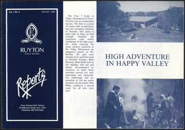 Ruyton Girls' School
Newsletter, Ruyton Reports, 1986
The Ruyton Reporter (formerly known as Ruyton Reports) captures the essential Ruyton Girls' School experience for the broader school community. It has been produced since 1986.The record has strong historic significance as it pertains to the fourth oldest girls' school in Victoria, Australia. Ruyton was founded in 1878 in the Bulleen Road, Kew, home of newly widowed Mrs Charlotte Anderson (now High Street South). Thus, the record can be used as a reference example for research into Victorian school history. It also gives insight into the types of activities and events undertaken at Ruyton Girls' School during the period of its production. The record's significance is further enhanced by its exceptionally well-documented provenance, having remained the property of Ruyton Girls' School since its production.Black and white newsletter printed on paper with staple binding. 8 pages.Front Page: Vol. 1 No. 2 AUGUST, 1986 / R / RECTE ET FIDE LITER / RUYTON / GIRLS' SCHOOL / Reports / From Ruyton Girls' School / 12 Selbourne Road, Kew. 3101 / Telephone (03) 819 2422 / The Year 7 Camp at / Valley Homestead in Ovens, / Victoria was an outstanding / success. The first in a series / of camps with an adventure / bias for secondary students / at Ruyton, this camp is / held in early June, so that / younger students can / experience early winter / conditions in the high coun- / try, while enjoying the / warm modern comforts of / the Valley Homestead. As / kangaroos grazed on Mt. / Buffalo, the girls were / introduced to activities such / as Obstacle Courses, Bush / Dancing, Bush Skills such as / fire lighting, first aid and / shelter. Accompanied by / members of staff, these / activities proved not only / interesting and enjoyable, / but challenging and ap- / propriate to the age group / involved. As the leader, Miss / Willis, explained a special / week for all who took / part. / HIGH ADVENTURE / IN HAPPY VALLEY /ruyton girls' school, ruyton, school, students, newsletter, ruyton reports, ruyton news, kew, victoria, melbourne, girls school -
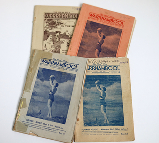 Warrnambool and District Historical Society Inc.
Booklet - The Ideal City Warrnambool On the Sea, 1944-1948
These booklets were issued in 1944 to 1948 by the Warrnambool Progress and Tourist Association(established in 1927). Warrnambool was the winner of the Sun News Pictorial Quest in 1928, the ‘Ideal City’ and used this title to promote the city. There had been several Tourist Associations in Warrnambool prior to 1927 and all of them promoted Warrnambool as a health resort and an ideal holiday destination with the Sea Baths in Gilles Street and the beach close by. These guides were produced during and immediately post World War Two with rationing of petrol and other goods and most people in Victoria would not have been contemplating long and expensive holidays so Warrnambool with its rail service and beach facilities would have been seen as a possible holiday destination. The booklets contain information on the tourist attractions of Warrnambool and district, black and white photographs of buildings, events and scenic spots and advertisements for local businesses. Many of the advertisements also contain photographs of business premises.These booklets are of interest as they contain photographs of Warrnambool in the mid to late 1940's and advertisements for many business operating at that time.[.1] 56 page booklet. The apricot cover has red printing and a picture of a young woman holding a beach ball aloft on the front. The white pages have black printing & blue coloured photographs. The last page is pink. [.2] 54 page stapled booklet. The pale blue cover has dark blue printing and a picture of a young woman holding a beach ball aloft on the front. There are three pink pages at the front. The remainder are white with black printing. This booklet contains a handwritten letter to the Warrnambool City Council and a yellow page typed reply acknowledging the donation. [.3] 48 page originally stapled booklet now held together with white cotton. The beige cover has dark blue printing and a picture of a young woman holding a beach ball aloft on the front. Name written in biro on front cover. There are blue and pink pages which contain photographs and an apricot coloured fold out map. [.4] 50 page booklet with rounded corners. The beige cover has brown printing and a drawing of a tennis player and golfer waving to two ladies in bathing costumes on the beach. There are sail boats, a mountain, clouds and a gum tree in the background. There are some coloured pages. [.1] The Ideal City WARRNAMBOOL ON THE SEA Victoria Australia Tourist Guide Where to Go! What to See! To Advance Warrnambool - "THE IDEAL CITY" Victoria's Premier Health and Holiday Resort - Price 6d. [.2] The Ideal City WARRNAMBOOL ON THE SEA Victoria Australia Tourist Guide Where to Go! What to See! To Advance Warrnambool - "THE IDEAL CITY" Victoria's Premier Health and Holiday Resort - Price 1/- [.3] The Ideal City WARRNAMBOOL ON THE SEA Victoria Australia Tourist Guide Where to Go! What to See! To Advance Warrnambool - "THE IDEAL CITY" Victoria's Premier Health and Holiday Resort - Price 1/6 Handwritten in biro Terry O'Sullivan - WCC 20/2/06 [.4] The Ideal City WARRNAMBOOL Victoria Australia ON THE SEA Happy Holiday Health Resort Surfing Boating Shooting Tourist Guide Where to Go! What to See! To Advance Warrnambool - "THE IDEAL CITY" Victoria's Premier Health and Holiday Resort - Price 1/6 Handwritten in biro 1948 warrnambool, ideal city, warrnambool tourist guide, warrnambool progress and tourist association, warrnambool tourism, warrnambool business advertisements -
 Bendigo Military Museum
Memorabilia - TRENCH ART, CHRISTMAS CARD, James Thomas Holl, 1918-19
Refers to the service of:- James Thomas Holl, No 2432. Enlisted 1/6/1916 age 39, in the 60 Bn, 5th Reinforcements. Embarked 25/8/1918, for England. Embarked 30/12/1918, for France. Hospital 17/6/1917, Influenza. Rejoined unit 8/3/1918. Hospital, Trench fever 29/4/1918. Rejoin unit 16/7/1918. Transfer to 59 Battn, 25/9/1918. Discharged 2/11/1919. These 'plates' were beaten out of "Fritz's" dixies. (Mess tin). These items could be classed as a type of trench art..1) This is a rectangular piece of flat aluminium. It is not perfectly square, it shows signs of having been panel beated. Words, drawings and numbers are hand engraved on both sides. The animal on this "card" is a kangaroo. .2) This is a flat rectangular plate of flat aluminium. It is not perfectly square, across the middle is a 'dint" that appears to have been a flattened out corner. Plate One: Side A. Kangaroo motif - engraved on this side: A souvenir of Peronne. Wishing you a Merry Christmas and Happy New Year 1918-1919. From France J.T.H. Side B - Engraved as per a postcard:- Carte postage France 14/10/18. Correspondence: Dearest Mother and Sisters, Just a card to say I am well. This is a bit of a xmas card. Love to all Jim. Addressee: Mrs Holl. "Holliston" Healesville, Victoria, Australia. Plate Two: Kookaburra Motif. Side A; Best wishes for Christmas and the New Year 1918-1919. A souvenir of Peronne, France - marked. (This side has the remains of some sort of official number - top right corner). Side B: Correspondence: My Dear wife and Family. A few lines to say I am well when writing this. This is a piece of Fritz's dixie. Love to all, Jim. Addressee: Mrs J.T. Holl, C/- Mrs Briggs, 103 Mollison Street, Bendigo, Victoria, Australia. Carte Postal - Stamp 6/10/18 France.christmas, aluminium, souvenirs -
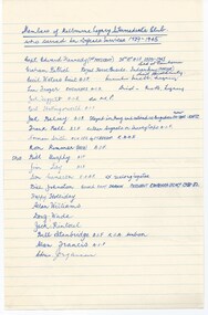 Melbourne Legacy
Document, Members of the Melbourne Intermediate Legacy Club who served in the Defence Services 1939-1945
A list of 22 members of the ILC who had served in the second world war and their details if known. A second note mentions that of 42 ILC members, there were 33 that served in the second world war. 12 in the AIF, 12 in the AMF, 8 in the RAAF, and 1 in the Indian Army. The balance were in reserved occupations or had ill health. Ranks held included 2 Majors, 2 Captains, 2 Lieutenants, and 1 pilot officer. Also noted was that 2 became POWs and one in the RAAF served in the No 10 Squadron. Background: The ILC was formed in 1929. The idea of the club sprang from those boys who had outgrown the Junior Legacy Club. In the early days it fielded a lacrosse team and it was this that mainly held the members together. Enthusiasm wained after a few years as it lacked a solid objective. The answer came from one of its members and in 1938 they founded the Don Esses Club. This was a club for the children of incapacitated ex-servicemen which met every Thursday night at 7.30 run by the ILC members. The name came from the signallers' code Disabled Servicemen's Sons. During the second world war 80% of the members of the ILC enlisted in the services. Leaving only 8 members that could not join due to ill health or reserved occupations. They continued the Don Esses and whatever aid they could to Legacy. ILC members had always helped Legacy where possible including being camp leaders or camp staff, with the annual demonstrations, and coffee stalls at the ANZAC dawn service. Post second world war some ILC members were nominated into Legacy, others drifted away in civil occupations. It was found difficult to recruit new blood into the ILC and eventually membership waned when the boys from the Don Esses clubs found other youth activities to join. The ILC ceased to meet regularly in the mid fifties. However a strong comradeship still existed between members and they would meet in one anothers homes. Members were always ready to help the senior Legacy Club in any way in their power and still helped at Christmas parties and summer camps. ILC was a service rendering organisation and was self governing. Non-sectarian and non-political, the members were ex-junior legatees over 18 years of age. After serving in World War 2 members were eligible to become members of Legacy. Was in a folder of material collated about the ILC by an early archive committee. List included: Edward Kennedy Graham Billiet, Cecil Waters, Len Frazer, Jack Suggett, Bert Hollingsworth, Jack Belsey, Frank Bell, Norman Smith, Ron Rimmer, Bill (Spud) Murphy, Jim Day, Don Cameron, Bill Johnston, Frank 'Happy' Holliday, Alan Williams, Doug Wade, Jack Rintoul, Bill Stanbridge, Alan Francis, Chris JorgensonA record of where the ILC members served in world war two and some of the ranks they attained. The ILC was active from 1929 to 1974.White lined note paper with handwritten list of members who served in World War 2.ilc, membership, junior legatee -
 Vision Australia
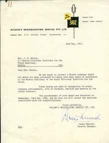
Certificate - Text, 3UZ Nicest Listener Award to Mrs J.R.Watson, 22/5/1963
Letter and certificate from radio station 3UZ to Mrs Watson, for her role at the RVIB Murtoa Auxiliary.1 letter and 1 cardboard certificateLetter: the greater 3UZ Telephone: 633511 Telegrams: 'Threeuz', Melbourne Nilsen's Broadcasting Service Pty Ltd Registered Office: 45-47 Bourke Street, Melbourne, C.1 22 May 1963 Mrs J.R. Watson, C/-Murtoa Victorian Institute for the Blind Auxiliary MURTOA VIC Dear Mrs Watson, We are happy to present a Nicest Listener Award for which you were nominated following your many years of assistance to the Murtoa Auxiliary of the Royal Victorian Institute for the Blind. These Awards are made in recogition of extra-ordinary achievements, acts of kindness, heroism and service in the public interest. The announcement of your Award was broadcast on Wednesday, 22nd May, 1963, and we hope you will accept the enclosed certificate with our congratulations. Yours faithfully, Nilsen's Broadcasting Service Pty Ltd. Lewis Bennett General Manager. Certificate: Nicest Listener Award Citation Mrs J.R. Watson for over thirty years of enthusiastic work done to assist the Murtoa Auxiliary of the Royal Victorian Institute for the Blind. 3UZ - the station with the nicest listeners Lewis Bennett, General Managerroyal victorian institute for the blind, edith emma watson, auxiliaries, lewis bennett, 3uz -
 Old Castlemaine Schoolboys Association Inc.
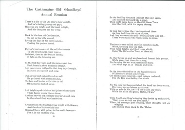
Poem, The Castlemaine Old Schoolboys' Annual Reunion
Written by George E Scott who was born in Creswick March 1900. Moved to Vaughan in 1904. Attended Yapeen State School utill 1913 then to Castlemaine high school and technical schools. Poem written in 1950s.There is a lift to the old boys step tonight, and is feeling young and gay his eyes are bright and his heart is light, and his thoughts are far away. Back in his dear old Castlemaine, or out in the hills around living the days of his youth again feeling his pulses bound. For he's just answered the call that comes to the loyal hearts every year insistent, clear as the beating of drums it falls on the listening ear so the old boy went and his mates went to back home in their hundreds strong and years were bridged in at long day through in story and speech and song. At at the Bush school love so well he gathered with his comrades gay, old Lads and Lassie's with tales to tell of memories tucked away. And bright eyed children had joined them in there happy young faces shone, as they showed old scholars are pride and care in the school that was handed on. Around them the bushland was bright with flowers, and the dear little orchid blue Bloom there with bright, in the sunlit bowers- for it is our emblem true. So the old boy drained through that day again, and it lifted his heart like a song, then Knight came down on the old home town and the hall, with its happy throng. In long brave lines they had mustered there as they had on the days of yore, and as they answered the roll - but the years take toll- there were mates who would come no more. The toast called, and the speeches made, when, trooping into the hall, with faces bright, and their eyes alight, came the girls- the toast of them all. So they broke up and wandered and formed into groups, while many have time for a song, But bashing the ear was permissible here, and they kept at it- steady and long. So the hours flitted by happiest notes of memories sweet old refrain, old friendships renewed - past doing's reviewed, the old boy was feeling strain. For his ears had been punished, his hand had been wrung, his voice was hoarse as a crow, with an ache in his jaw- "I can't take any more, while I'm all in one piece, mates, I'll go." With Auld lang syne is singing a broke up and parted, "next year we will see you again" when the message goes ringing, their thoughts will go winging and calling them back to 'Mainepoem, yapeen -
 Bendigo Historical Society Inc.
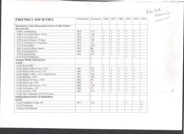
Document - LIST OF FRIENDLY SOCIETIES: BENDIGO
Three pages of research by Rita Hull on Friendly Societies. Includes name of Society, when established, the number of Members, and the years 1865,1875, 1881,1891, 1895 and 1907 (an asterisk if they were still operating). Listed are the Society names and the different Court, Lodge, etc. under the name. They are: Manchester Unity Independent Order of Odd Fellows M.U.I.O.O.F. - Loyal Bendigo Loyal Gold Miners' Pride, Loyal James Roe, Loyal Strangers' Refuge, Loyal Heart of Friendship, Loyal Albert, Loyal Sir Henry Barkly, Loyal Catherine, Loyal Darling and Earl of Hopetoun. Ancient Order of Foresters A.O.F. - Court Royal Oak, Court Queen of the Forest, Court Pride of the Forest, Court Happy Valley, Court Bendigo, Court Banner of Hope, Court Sherwood, Court King of the Forest, Court Alexandra, Court Victoria and Court Star of Bendigo (Women). Independent Order of Oddfellows I.O.O. - Loyal Sandhurst Lodge, Court Weeroona and Golden Star Rebekah. Independent Order of Rechabites I.O.R. - Tent Star of Bendigo, Tent Refuge, Tent Cobden, Tent Olive Branch, Tent Laurel, Tent Sutton and Tent Herald of Peace. Sons and Daughters of Temperance - Royal Diadem Division, Ark of Safety, Royal Septre, Hope of Sandhurst (Ladies), Princess Beatrice (Ladies), Lady Loch (Ladies) and Laurel (Ladies). Grand United Order of Oddfellows G.U.O.O.F. - Lodge Star of Eaglehawk, Lodge Sandhurst, Lodge Pride of Bendigo, Lodge Olive Branch and Lodge Belvidere. United Ancient Order of Druids U.A.O.D. - Lodge Quartzopolis, Lodge Eldorado, Lodge Caractacus, Lodge Bendigo and Lodge Sandhurst. Order of St Andrew (Scottish Constitution) - Bendigo Lodge No 1. Order of St Andrew (All Nations) - Lodge Sandhurst and Lodge Unity. Royal Antediluvian Order of Buffaloes R.A.O.B. - Provincial Grand Lodge No 1, Prairie Lodge, Forest Lodge and Southern Cross Lodge. The Hibernian Australasian Catholic Benefit Society H.A.C.B.S. - St Kilian's No 4 and Eaglehawk Branch. Independent Order of Good Templars - Lodge Bendigo, Lodge Guiding Star, and Lodge Hope of Golden Square. Loyal Orange Institution of Victoria - Lodge William Lodge and Loyal Governor Bowen (Pride of Eaglehawksocieties, order of .., list, list of friendly societies, rita hull, manchester unity independent order of odd fellows m.u.i.o.o.f., ancient order of foresters a.o.f., independent order of oddfellows i.o.o., independent order of rechabites i.o.r., sons and daughters of temperance, grand united order of oddfellows g.u.o.o.f., united ancient order of druids u.a.o.d., order of st andrew (scottish constitution), order of st andrew (all nations), royal antediluvian order of buffaloes r.a.o.b., the hibernian australasian catholic benefit society h.a.c.b.s., independent order of good templars, loyal orange institution of victoria, australian natives association a.n.a. -
Tarnagulla History Archive
Set of Maps (Mining & Local Area), various
David Gordon Collection. A set of mining documents, maps and plans: 1. Dunolly Deep Leads - showing location and names of deep lead gold deposits in region around Dunolly including at Tarnagulla and Newbridge. Geological Survey of Victoria, Department of Minerals and Energy. Bulletin No. 62, Map No. 4 Dunolly (770 x 485 mm). 2. Poseidon Lead (Facsimile) 3. Nick O Time Lead (Facsimile) 4. Happy Go Lucky Mine prospectus and plan (colour copy) 5. Jones Creek GM Co. (Raven & Gourlay's) Waanyarra - Prospectus (colour copy) 6. Poseidon Area Plan (colour copy) and Poseidon Area map (B&W copy). 7. Cross-section diagram of Spread Eagle Reef 8. New Birthday Gold Mine - area map (colour copy) and mine cross-section ( (colour copy). 9. Cross section of Poverty Reef, by Department of Mines (B&W copy, 2 parts on A2 paper) 10. Time-Lease Graph for Watts Reef, Specimen Reef, Stony Reef, Poverty Reef (second page in detail), created by Eric WIlkinson for Ref Mining NL, 1995 11. 1859 Plan of the Gold Workings & Township of Sandy Creek, Shewing the Mining Leases, Extended Claims & Machinery by R.J. McMillan, Mining Surveyor (B&W copy) 12. Longitundinal and Transverse Vertical Sections of Poverty Reef, Sandy Creek 1859, by R.J. McMillan, Mining Surveyor (B&W copy) 13. Tarnagulla Locality Plan (B&W copy) 14. Universal Grid Reference Map (Topographic) for Laanecoorie North (2 copies) 15. Universal Grid Reference Map (Topographic) for Inglewood South 16. Poverty Reef, Plan showing shafts and early tenements, created by Eric WIlkinson for Ref Mining NL, 1995 17. Locality Map of mining leases in Tarnagulla 18. Plan and Elevation of part of Poverty Reef, Sandy Creek, showing the claims and positions of the shaft. by R.J. McMillan, Mining Surveyor (Facsimile, composed of taped together components) 19.Plan and Elevation of part of Poverty Reef, Sandy Creek, showing the claims and positions of the shaft. by R.J. McMillan, Mining Surveyor (Facsimile, composed of taped together components) -
 Coal Creek Community Park & Museum
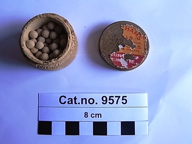
Box, pill, 1930-1940 ref: Museum of Applied Arts and Sciences
As per another example in better condition displayed on shelf above Drawers 1+2 in Chemist ' Beechams Pills as sold by the proprietors St.Helens, Lancashire England. Beechams Pills Ltd. Melbourne VIC'. Earliest mention in Victorian Newspapers TROVE : Argus (Melbourne, Vic. : 1848 - 1957), Friday 19 December 1884, page 7 'A WONDERFUL MEDICINE BEECHAMS PILLS Are admitted by thousands to be worth above a guinea a box for bilious and nervous disorders such as wind and pain in tho stomach, sick headache, giddiness, fulness and swelling after meals dizziness and drowsiness, cold chills, flushings of heat, loss of appetite, shortness of breath costiveness, scurvy, blotches on the skin, disturbed sleep, frightful dreams, and all nervous and trembling sensations, &c The first dose will give relief in 20 minutes This is no fiction, for they have done it in thousands of cases. Every sufferer Is earnestly invited to try one box of these pills, and they will be acknowledged to be WORTH A GUINEA A BOX. For females of all ages these pills are invaluable as a few doses of them carry off all humours and bring about all that is required No female should be with-out them There is no medicine to be found to equal Beecham's Pills for removing any obstruction or Irregularity of the system. If taken according to the directions given with each box they will soon restore females of all ages to sound and robust health For a weak stomach, impaired digestion, and all disorders of the liver they act like "Magic, and a few doses will be found to work wonders upon the most important organs of the human machine They strengthen tho whole muscular system, restore the long lost complexion bring back the keen edge of appetite, and arouse into action with the rosebud of health, the whole physical energy of the human frame These are ' facts ' admitted by thousands embracing all classes of society, and one of the best guarantees to the nervous and debilitated Is Beechams Pills have the largest sale of any patent medicine in the world Full directions are given with each box Sold by all druggists and patent medicine dealers throughout the colonies'. Most recent article in Victorian newspapers : TROVE : Wodonga and Towong Sentinel (Vic. : 1885 - 1954), Friday 24 December 1954, page 1. 'MUM KNOWS BEST SHE KEEPS THE FAMILY FIT WITH BEECHAM'S PILLS SAFE because Beecham's Pills contain no harmful habit-forming drugs-they are a purely vegetable laxative. Pills balanced formula gives natural laxative action without harsh purgative effects banishes constipation. MOTHERS know how to keep growing children in their teens fit and happy-with Beecham' s Pill, the family laxative. TAKE Beecham's Pills WORTH A GUINEA A BOX'. Relevant local newspaper article reference : TROVE : Gippsland Times (Vic. : 1861 - 1954), Thursday 29 October 1942, page 1 'ln times like these old friends are best You will not have to go far before finding a friend who can tell you by personal experience how gentle and reliable Beecham's Pills are--and how effectively they banish head aches. digestive upsets and liverish ness. Purely vegetable....1/-....2/...per box Worth a guinea a box' Cylindrical wooden box with the remains of an orange, red and white printed label on top, containing small orb shaped pills.Label on lid : Beecham's pills...............Beecham's Pills Ltd., Melbourne, Vic.laxitive, pills -
 Melbourne Legacy
Document, History (H33) By Frank Meldrum, 1976
A document written in 1976 by Legatee Frank Meldrum containing his account of the start of Legacy. He was responding to a request for information about the history of Legacy that the archive committee was collating. He mentions several key members by name and what they achieved. As with other similar accounts he mentions the original objective was to see diggers placed in employment. When two years later the focus changed to the families 'thanks to Frank Doolan Legacy found its SOUL'. Many other accounts have also used the term 'soul' when referring to Frank's suggestion. It seems many Legatees had been quietly helping families of their comrades; Frank 'said he was helping a widow with two children of an old army mate. It was discovered that several of the Board were doing the same. Stan Savige had taken over the care of his widowed sister and her two boys, whose father had died at Passchendale. I had a widow with two little ones whose father was one of my best mates at Anzac. He died of flu virus after returning to Australia. I think eleven members of the Board or Committees were already giving similar service. Frank's proposal caught on immediately. Legacy had found its Soul!' 'Harold Peters started his Lit and Debating Class and I was asked by Stan to find a PT instructor', Frank Meldrum asked for the 'Billy' Williams to helped, and a cobber from Anzac, Louis Vavjanezki, to take on boxing and wrestling classes. 'All committees carried their own expenses amongst themselves - nothing was charged to JLC. Hugh Brain started the Education Committee and was given a donation, I think of $1000 (a heck of a lot in those days) by the Ballieu Bros.' He also mentions 'For the first 5-10 years practically all administrative costs were borne by the members.' 'Stan Savige was, of course a tremendous driving force in all the work for the Juniors. He put on a Christmas Camp at Balnarring on his own property and was Camp Commandant and Camp Cook.' Legatee Keith Mitchell helped Frank Meldrum in doing a dental examination of all children in the classes and then Frank did the necessary treatments in his rooms. When it was known they were treating over 400 children and their mums, Syd Birrell then got the board to co-opt two more dentists into the Club and form a Dental Clinic. Syd Birrell also started a Legal Committee to provide free legal advice. 'Committees quietly vied with each other to give better services to the Juniors and their mums. It was an atmosphere that was unbelievably happy - SERVCE WITHOUT SELF'. He mentions picnics, including one at Grimwade house - photos are at 01382 - where legatees were dressed up. The first demonstration was held in the 'Playhouse, just over Princes Bridge and was a great success.' Aaron Beattie and Mrs Gilles were mentioned. The notation H33 in red pen shows that it was part of the archive project that was trying to capture the history of Legacy. A summary of the first fifty years of Legacy written by a key founding member.White foolscap paper with black type x 6 pages of Frank Meldrum's account of Legacy's history dated 6 March 1976.Handwritten H33 in red pen and 'from Meldrum' in blue pen on first page. Stamped 'COPY ONLY' in purple ink.history, founding legatee, frank meldrum -
 Ballarat Tramway Museum
Film - Movie Film & Box, 1971
Yields information in movie film format of Ballarat trams and news stories in the period 1965 to 1971 - BTV6 16mm film format., Yields information in movie film format of Ballarat trams and news stories in the period 1965 to 1971 - BTV6 16mm film format.Movie film - 16mm, approx. 5:29 mins, with grey leader strip on a blue plastic Tuscan Reel, with sound track, leader and timer count down strip; c1965 to 1971. Has been transferred to DVD - see Reg item 4100 as Segment No. 7. Compiled from BTV6 film by Paul McDonald c1990. Synopsis: based on time - Black and white film. Title "Ballarat trams" 0:00 Bogie tram arriving behind another bogie tram at the City Centre, Sturt St nth side, passengers boarding tram, view of destination, Mt. Pleasant, Lydiard St Nth, view of Sturt St, north side, with motor vehicles and building in street, and No. 41 turning from Sturt St into Lydiard St. 0:42 Short sequence of a bogie tram in Sturt St, view from window and a driver working the controller. 0:58 Interview on tram with two ladies about the tram service and the staff. (Sound) 1:36 Sequence varying scenes about the 60th anniversary of trams in Ballarat, including on tram, people, No. 18 leaving the depot with the 60th anniversary dash front panel for the event. 2:16 Courier poster “SEC Says: Trams should be scrapped” 2:23 Lydiard St Nth terminus, ladies waiting at terminus shelter, and No. 43 arriving at terminus 2:36 Front of bus with bus destination roll being scrolled, Creswick, Wendouree, Mt Pleasant, view of a Davis Bus outside the Town Hall, view of people (guests) chatting on the bus, all looking very happy, and view of bus travelling along. 3:15 No. 33 and bus, showing special alongside at Victoria St terminus and back to bus interior shot. 3:25 No. 12 loaded on a truck and leaving from insider the depot and out in Wendouree Parade with jacks on rear of truck. 3:59 No. 33 loaded for Hamilton leaving Ballarat (note without the truck attached), and being backed into position for offloading. 4:42 No. 41 loaded on a truck, being backed into an position to be offloaded 4.54 No. 36 with Tourism Week Sign being prepared and lifted at the depot. 5:29 End. Placed in a blue cardboard box specially made for the item 30/08/2010.trams, tramways, ballarat, city centre, lydiard st nth, buses, davis bus lines, tram disposal, tram 33, tram 41, tram 36, tram 18 -
 Eltham District Historical Society Inc
Photograph, Upper Yarra Dam, Spring Tour, 22 Oct 1995, 22/10/1995
EXPLORING THE UPPER YARRA (Newsletter No. 105, November 1995, by Bettina Woodburn) We enjoyed the Spring Excursion, this year "Exploring the Upper Yarra" - in spite of the constant rain and the countryside under the cloud cover, especially in the valleys, being mainly shiny shades of green. The occasional fields of buttercups, clumps of arum lilies and splendid rhododendron and other flowering bushes became very special. The Cobb and Co coach was warm and a cosy retreat as we zig-zagged on the highways and byways to glimpse the Yarra River, upstream and down, its secret places, and particularly the many bridges. Russell excelled as 'Poet Laureate', reading from Dacre Smyth's book. This 1979 publication includes paintings of all the bridges along the river with poems and brief descriptions of each one. Some of the bridges are in out of the way places and are not very well known. We looked forward to hearing the poetry as much as seeing the ' constructions'…Big Pat (was he short or tall, lean or fat? He did win the two hundred pound reward for discovering gold and had the creek named after him), about the 'Eddies'?, and the disliked 'meccano' bridge in Warburton, etc. etc. The hot roast lunch in the old Reefton Hotel was also most welcome. It was easy to imagine it peopled by miners and early settlers. Starting by crossing the new (1974) concrete bridge at Warrandyte we headed through Wonga Park with views to the Christmas Hills and to the escarpment of the Yering Gorge, which causes flood waters to back up through the Yarra Glen plain, so avoiding disasters downstream. At the end of a long driveway we found the wooden, privately owned Henley Bridge (1935 after the 1934 floods). This facilitates access to different parts of Henley Farm and to Lilydale. Everard Park, named after Blanche Shallard's father, a State Member for 17 years, below the Highway Yarra crossing was in need of care. It is 10 miles from Yarra Glen by road but, as "Yarra Marra” canoeists well know, 32 winding miles down by water. After more delightful countryside scenes we joined the Warburton Highway at Woori Yallock. From the old Railway Station at Launching Place the Centennial Trail for walkers, cyclists and ' horse riders has replaced the rails. The line from Lilydale was opened in 1901, and the last diesel freight train ran to Warburton in 1965. It continued to rain as we had morning tea in Warburton in a shelter between footbridges. From here we continued upstream past the Bridge to O'Shannasy Lodge and Reservoir, Starvation Creek, and the Peninsular tunnel (miners dug it as at Pound Bend) which we visited (scrambling down those steps!) on our return after lunch. Our furthermost point was the Upper Yarra Dam Reserve (and vast catchment area). Finished in 1957 after ten years work and 100 years after Yan Yean, it supplies much of Melbourne's water. After crossing the 30m Launching Place Bridge to the Eltham side of the Yarra and Healesville, we saw in the distance the Yarra Glen Timber Trestle Bridge over the river flats "the longest for years in the land it was said!" Harry's dream of "better weather over the Divide" unfortunately didn't come true, but I'm sure we 36 members will retain happy memories of a day that was wet and green and filled with Bridges. Bettina Woodburn - October 1995 Record of the Society's history of activities - Spring 1995 excursionColour photographshire of eltham historical society, activities, upper yarra dam, henley bridge -
 Eltham District Historical Society Inc
Photograph, Upper Yarra Dam, Spring Tour, 22 Oct 1995, 22/10/1995
EXPLORING THE UPPER YARRA (Newsletter No. 105, November 1995, by Bettina Woodburn) We enjoyed the Spring Excursion, this year "Exploring the Upper Yarra" - in spite of the constant rain and the countryside under the cloud cover, especially in the valleys, being mainly shiny shades of green. The occasional fields of buttercups, clumps of arum lilies and splendid rhododendron and other flowering bushes became very special. The Cobb and Co coach was warm and a cosy retreat as we zig-zagged on the highways and byways to glimpse the Yarra River, upstream and down, its secret places, and particularly the many bridges. Russell excelled as 'Poet Laureate', reading from Dacre Smyth's book. This 1979 publication includes paintings of all the bridges along the river with poems and brief descriptions of each one. Some of the bridges are in out of the way places and are not very well known. We looked forward to hearing the poetry as much as seeing the ' constructions'…Big Pat (was he short or tall, lean or fat? He did win the two hundred pound reward for discovering gold and had the creek named after him), about the 'Eddies'?, and the disliked 'meccano' bridge in Warburton, etc. etc. The hot roast lunch in the old Reefton Hotel was also most welcome. It was easy to imagine it peopled by miners and early settlers. Starting by crossing the new (1974) concrete bridge at Warrandyte we headed through Wonga Park with views to the Christmas Hills and to the escarpment of the Yering Gorge, which causes flood waters to back up through the Yarra Glen plain, so avoiding disasters downstream. At the end of a long driveway we found the wooden, privately owned Henley Bridge (1935 after the 1934 floods). This facilitates access to different parts of Henley Farm and to Lilydale. Everard Park, named after Blanche Shallard's father, a State Member for 17 years, below the Highway Yarra crossing was in need of care. It is 10 miles from Yarra Glen by road but, as "Yarra Marra” canoeists well know, 32 winding miles down by water. After more delightful countryside scenes we joined the Warburton Highway at Woori Yallock. From the old Railway Station at Launching Place the Centennial Trail for walkers, cyclists and ' horse riders has replaced the rails. The line from Lilydale was opened in 1901, and the last diesel freight train ran to Warburton in 1965. It continued to rain as we had morning tea in Warburton in a shelter between footbridges. From here we continued upstream past the Bridge to O'Shannasy Lodge and Reservoir, Starvation Creek, and the Peninsular tunnel (miners dug it as at Pound Bend) which we visited (scrambling down those steps!) on our return after lunch. Our furthermost point was the Upper Yarra Dam Reserve (and vast catchment area). Finished in 1957 after ten years work and 100 years after Yan Yean, it supplies much of Melbourne's water. After crossing the 30m Launching Place Bridge to the Eltham side of the Yarra and Healesville, we saw in the distance the Yarra Glen Timber Trestle Bridge over the river flats "the longest for years in the land it was said!" Harry's dream of "better weather over the Divide" unfortunately didn't come true, but I'm sure we 36 members will retain happy memories of a day that was wet and green and filled with Bridges. Bettina Woodburn - October 1995 Record of the Society's history of activities - Spring 1995 excursionRoll of 35mm colour negative film, 3 stripsKodak Gold 200-4shire of eltham historical society, activities, upper yarra dam, henley bridge -
 Eltham District Historical Society Inc
Photograph, Upper Yarra Dam, Spring Tour, 22 Oct 1995, 22/10/1995
EXPLORING THE UPPER YARRA (Newsletter No. 105, November 1995, by Bettina Woodburn) We enjoyed the Spring Excursion, this year "Exploring the Upper Yarra" - in spite of the constant rain and the countryside under the cloud cover, especially in the valleys, being mainly shiny shades of green. The occasional fields of buttercups, clumps of arum lilies and splendid rhododendron and other flowering bushes became very special. The Cobb and Co coach was warm and a cosy retreat as we zig-zagged on the highways and byways to glimpse the Yarra River, upstream and down, its secret places, and particularly the many bridges. Russell excelled as 'Poet Laureate', reading from Dacre Smyth's book. This 1979 publication includes paintings of all the bridges along the river with poems and brief descriptions of each one. Some of the bridges are in out of the way places and are not very well known. We looked forward to hearing the poetry as much as seeing the ' constructions'…Big Pat (was he short or tall, lean or fat? He did win the two hundred pound reward for discovering gold and had the creek named after him), about the 'Eddies'?, and the disliked 'meccano' bridge in Warburton, etc. etc. The hot roast lunch in the old Reefton Hotel was also most welcome. It was easy to imagine it peopled by miners and early settlers. Starting by crossing the new (1974) concrete bridge at Warrandyte we headed through Wonga Park with views to the Christmas Hills and to the escarpment of the Yering Gorge, which causes flood waters to back up through the Yarra Glen plain, so avoiding disasters downstream. At the end of a long driveway we found the wooden, privately owned Henley Bridge (1935 after the 1934 floods). This facilitates access to different parts of Henley Farm and to Lilydale. Everard Park, named after Blanche Shallard's father, a State Member for 17 years, below the Highway Yarra crossing was in need of care. It is 10 miles from Yarra Glen by road but, as "Yarra Marra” canoeists well know, 32 winding miles down by water. After more delightful countryside scenes we joined the Warburton Highway at Woori Yallock. From the old Railway Station at Launching Place the Centennial Trail for walkers, cyclists and ' horse riders has replaced the rails. The line from Lilydale was opened in 1901, and the last diesel freight train ran to Warburton in 1965. It continued to rain as we had morning tea in Warburton in a shelter between footbridges. From here we continued upstream past the Bridge to O'Shannasy Lodge and Reservoir, Starvation Creek, and the Peninsular tunnel (miners dug it as at Pound Bend) which we visited (scrambling down those steps!) on our return after lunch. Our furthermost point was the Upper Yarra Dam Reserve (and vast catchment area). Finished in 1957 after ten years work and 100 years after Yan Yean, it supplies much of Melbourne's water. After crossing the 30m Launching Place Bridge to the Eltham side of the Yarra and Healesville, we saw in the distance the Yarra Glen Timber Trestle Bridge over the river flats "the longest for years in the land it was said!" Harry's dream of "better weather over the Divide" unfortunately didn't come true, but I'm sure we 36 members will retain happy memories of a day that was wet and green and filled with Bridges. Bettina Woodburn - October 1995 Record of the Society's history of activities - Spring 1995 excursionRoll of 35mm colour negative film, 3 stripsKodak Gold 200-4shire of eltham historical society, activities, upper yarra dam, henley bridge