Showing 4634 items
matching historical maps
-
 Eltham District Historical Society Inc
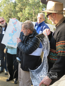
Photograph, Liz Pidgeon, Heritage Excursion; Eltham Lower Park Walk and Talk, 1 July 2017, 1 July 2017
Local Historian Russell Yeoman and EDHS President Jim Connor with a map and aerial photograph of the area the heritage walk will cover. Newsletter No., 234, June 2017 Heritage Excursion - Saturday 1st July - Eltham Lower Park - Walk and Talk Eltham Lower Park has played an important part in the history of our area since the early days of European settlement when it was used by local residents as an informal racecourse. Prior to that its location at the junction of the Diamond Creek and the Yarra River made it an important meeting place for the Wurundjeri people. The park combines formal elements and sporting facilities with remnant bushland that is of environmental significance. It is home to sporting and horse riding clubs, popular play spaces and the Diamond Valley Miniature Railway, which attracts large numbers of visitors. The park will be the venue for our July excursion which will comprise a walk of about 3.5 km around the park and adjacent areas. Along the way we will discuss the history and natural history of the area. The path along the creek and the river provides a pleasant and scenic walk. This walk on Saturday 1st July is about 3.5 km in length and will take 2 to 2.5 hours. It will start at 2pm at the Main Road car park at the front of the park. (Melway ref 21 H 10). Born Digitalheritage excursion, activities, eltham district historical society, eltham lower park, russell yeoman, jim connor, guide -
 Eltham District Historical Society Inc
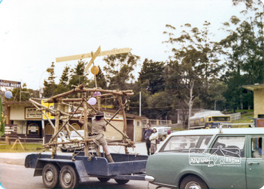
Photograph, Eltham Fire Brigade, Eltham Community Festival Parade, Main Road opposite Wingrove Park, 4 August 1978, 04/08/1978
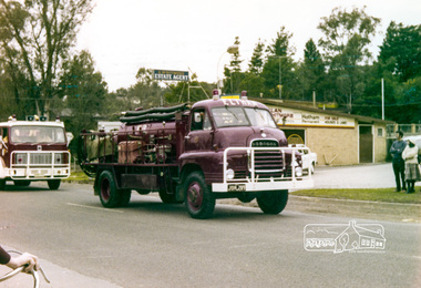
Eltham Community Festival, 4-13 August 1978 Newsletter No. 3 September 1978 Eltham Community Festival. This year’s Eltham Community Festival was held from August 4th to 13th. The society was involved with the Warrandyte Historical Society in arranging an exhibition at the Community Centre and also provided notes and a map for a self-guided walking tour of historic buildings and locations around Eltham. Copies of notes will continue to be available from the Eltham Shire Offices and the tour may be under-taken at any time. The exhibition was divided into two sections. The Eltham Society displayed early photographs associated with the walking tour, whilst the Warrandyte Society showed their photographs and artefacts of the Warrandyte gold era. An outstanding feature was the large "blow-up" photos of early Warrandyte. Colour photographeltham, main road, eltham festival, alan whitmore estate agents, shell service station, mount pleasant road, parade, parade float, wingrove park, fire brigrade -
 Eltham District Historical Society Inc
Photograph, 2nd Eltham Sea Scouts, Eltham Parade, Main Road opposite Wingrove Park, August 1978, 04/08/1978
Eltham Community Festival, 4-13 August 1978 Newsletter No. 3 September 1978 Eltham Community Festival. This year’s Eltham Community Festival was held from August 4th to 13th. The society was involved with the Warrandyte Historical Society in arranging an exhibition at the Community Centre and also provided notes and a map for a self-guided walking tour of historic buildings and locations around Eltham. Copies of notes will continue to be available from the Eltham Shire Offices and the tour may be under-taken at any time. The exhibition was divided into two sections. The Eltham Society displayed early photographs associated with the walking tour, whilst the Warrandyte Society showed their photographs and artefacts of the Warrandyte gold era. An outstanding feature was the large "blow-up" photos of early Warrandyte. Two colour photographseltham, main road, eltham festival, alan whitmore estate agents, shell service station, mount pleasant road, parade, parade float, wingrove park, 2nd eltham sea scouts -
 Eltham District Historical Society Inc
Photograph, Our Lady's School, Eltham Community Festival Parade, Main Road opposite Wingrove Park, 4 August 1978, 04/08/1978
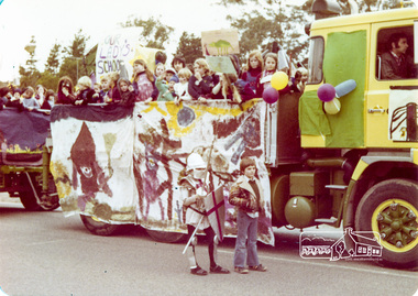
Eltham Community Festival, 4-13 August 1978 Newsletter No. 3 September 1978 Eltham Community Festival. This year’s Eltham Community Festival was held from August 4th to 13th. The society was involved with the Warrandyte Historical Society in arranging an exhibition at the Community Centre and also provided notes and a map for a self-guided walking tour of historic buildings and locations around Eltham. Copies of notes will continue to be available from the Eltham Shire Offices and the tour may be under-taken at any time. The exhibition was divided into two sections. The Eltham Society displayed early photographs associated with the walking tour, whilst the Warrandyte Society showed their photographs and artefacts of the Warrandyte gold era. An outstanding feature was the large "blow-up" photos of early Warrandyte. Colour photographeltham, main road, eltham festival, alan whitmore estate agents, shell service station, mount pleasant road, parade, parade float, wingrove park, our ladys school -
 Eltham District Historical Society Inc
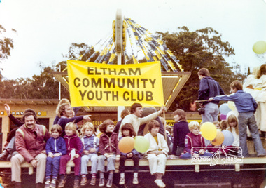
Photograph, Eltham Community Youth Club, Eltham Community Festival Parade, Main Road opposite Wingrove Park, 4 August 1978, 04/08/1978
Eltham Community Festival, 4-13 August 1978 Newsletter No. 3 September 1978 Eltham Community Festival. This year’s Eltham Community Festival was held from August 4th to 13th. The society was involved with the Warrandyte Historical Society in arranging an exhibition at the Community Centre and also provided notes and a map for a self-guided walking tour of historic buildings and locations around Eltham. Copies of notes will continue to be available from the Eltham Shire Offices and the tour may be under-taken at any time. The exhibition was divided into two sections. The Eltham Society displayed early photographs associated with the walking tour, whilst the Warrandyte Society showed their photographs and artefacts of the Warrandyte gold era. An outstanding feature was the large "blow-up" photos of early Warrandyte. Colour photographeltham, main road, eltham festival, alan whitmore estate agents, shell service station, mount pleasant road, parade, parade float, wingrove park -
 Eltham District Historical Society Inc
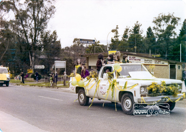
Photograph, Eltham Community Festival Parade, Main Road opposite Wingrove Park, 4 August 1978, 04/08/1978
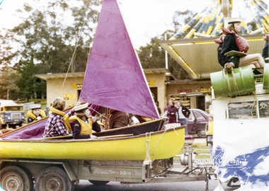
Eltham Community Festival, 4-13 August 1978 Newsletter No. 3 September 1978 Eltham Community Festival. This year’s Eltham Community Festival was held from August 4th to 13th. The society was involved with the Warrandyte Historical Society in arranging an exhibition at the Community Centre and also provided notes and a map for a self-guided walking tour of historic buildings and locations around Eltham. Copies of notes will continue to be available from the Eltham Shire Offices and the tour may be under-taken at any time. The exhibition was divided into two sections. The Eltham Society displayed early photographs associated with the walking tour, whilst the Warrandyte Society showed their photographs and artefacts of the Warrandyte gold era. An outstanding feature was the large "blow-up" photos of early Warrandyte. Colour photographeltham, main road, eltham festival, alan whitmore estate agents, shell service station, mount pleasant road, parade, parade float, wingrove park -
 Eltham District Historical Society Inc
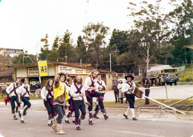
Photograph, Eltham Community Festival Parade, Main Road opposite Wingrove Park, 4 August 1978, 04/08/1978
Eltham Community Festival, 4-13 August 1978 Newsletter No. 3 September 1978 Eltham Community Festival. This year’s Eltham Community Festival was held from August 4th to 13th. The society was involved with the Warrandyte Historical Society in arranging an exhibition at the Community Centre and also provided notes and a map for a self-guided walking tour of historic buildings and locations around Eltham. Copies of notes will continue to be available from the Eltham Shire Offices and the tour may be under-taken at any time. The exhibition was divided into two sections. The Eltham Society displayed early photographs associated with the walking tour, whilst the Warrandyte Society showed their photographs and artefacts of the Warrandyte gold era. An outstanding feature was the large "blow-up" photos of early Warrandyte. Colour photographeltham, main road, eltham festival, alan whitmore estate agents, shell service station, mount pleasant road, parade, parade float, wingrove park -
 Eltham District Historical Society Inc
Photograph, Country Womens Association Montmorency, Eltham Community Festival Parade, Main Road opposite Wingrove Park, 4 August 1978, 04/08/1978
Eltham Community Festival, 4-13 August 1978 Second photo of 5 ladies very motion blurred but ladies named are L to R: Edi Levi, Joyce Finster, Thelma Smith, Jean Spencer, Norma Williams. Newsletter No. 3 September 1978 Eltham Community Festival. This year’s Eltham Community Festival was held from August 4th to 13th. The society was involved with the Warrandyte Historical Society in arranging an exhibition at the Community Centre and also provided notes and a map for a self-guided walking tour of historic buildings and locations around Eltham. Copies of notes will continue to be available from the Eltham Shire Offices and the tour may be under-taken at any time. The exhibition was divided into two sections. The Eltham Society displayed early photographs associated with the walking tour, whilst the Warrandyte Society showed their photographs and artefacts of the Warrandyte gold era. An outstanding feature was the large "blow-up" photos of early Warrandyte. Two colour photographs (one very blurry but with members names on it)eltham, main road, eltham festival, alan whitmore estate agents, shell service station, mount pleasant road, parade, parade float, wingrove park, country women's association, montmorency, edi levi, joyce finster, thelma smith, jean spencer, norma williams -
 Eltham District Historical Society Inc
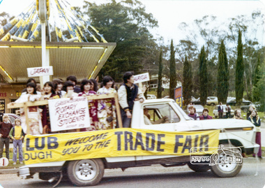
Photograph, Rotary Exchange Students, Eltham Community Festival Parade, Main Road opposite Wingrove Park, 4 August 1978, 04/08/1978
Eltham Community Festival, 4-13 August 1978 Second photo of 5 ladies very motion blurred but ladies named are L to R: Edi Levi, Joyce Finster, Thelma Smith, Jean Spencer, Norma Williams. Newsletter No. 3 September 1978 Eltham Community Festival. This year’s Eltham Community Festival was held from August 4th to 13th. The society was involved with the Warrandyte Historical Society in arranging an exhibition at the Community Centre and also provided notes and a map for a self-guided walking tour of historic buildings and locations around Eltham. Copies of notes will continue to be available from the Eltham Shire Offices and the tour may be under-taken at any time. The exhibition was divided into two sections. The Eltham Society displayed early photographs associated with the walking tour, whilst the Warrandyte Society showed their photographs and artefacts of the Warrandyte gold era. An outstanding feature was the large "blow-up" photos of early Warrandyte. Colour photographeltham, main road, eltham festival, alan whitmore estate agents, shell service station, mount pleasant road, parade, parade float, wingrove park, rotary -
 Eltham District Historical Society Inc
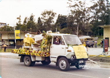
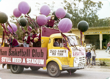
Photograph, Eltham Basketball Club, Eltham Community Festival Parade, Main Road opposite Wingrove Park, 4 August 1978, 04/08/1978
Eltham Community Festival, 4-13 August 1978 Newsletter No. 3 September 1978 Eltham Community Festival. This year’s Eltham Community Festival was held from August 4th to 13th. The society was involved with the Warrandyte Historical Society in arranging an exhibition at the Community Centre and also provided notes and a map for a self-guided walking tour of historic buildings and locations around Eltham. Copies of notes will continue to be available from the Eltham Shire Offices and the tour may be under-taken at any time. The exhibition was divided into two sections. The Eltham Society displayed early photographs associated with the walking tour, whilst the Warrandyte Society showed their photographs and artefacts of the Warrandyte gold era. An outstanding feature was the large "blow-up" photos of early Warrandyte. Colour photographeltham, main road, eltham festival, alan whitmore estate agents, shell service station, mount pleasant road, parade, parade float, wingrove park, eltham basketball club -
 Eltham District Historical Society Inc
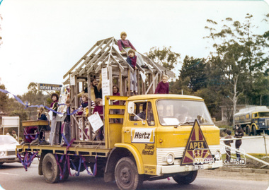
Photograph, Apex, Eltham Parade, Eltham Community Festival Parade, Main Road opposite Wingrove Park, 4 August 1978, 04/08/1978
Eltham Community Festival, 4-13 August 1978 Newsletter No. 3 September 1978 Eltham Community Festival. This year’s Eltham Community Festival was held from August 4th to 13th. The society was involved with the Warrandyte Historical Society in arranging an exhibition at the Community Centre and also provided notes and a map for a self-guided walking tour of historic buildings and locations around Eltham. Copies of notes will continue to be available from the Eltham Shire Offices and the tour may be under-taken at any time. The exhibition was divided into two sections. The Eltham Society displayed early photographs associated with the walking tour, whilst the Warrandyte Society showed their photographs and artefacts of the Warrandyte gold era. An outstanding feature was the large "blow-up" photos of early Warrandyte. Colour photographeltham, main road, eltham festival, alan whitmore estate agents, shell service station, mount pleasant road, parade, parade float, wingrove park, apex -
 Eltham District Historical Society Inc
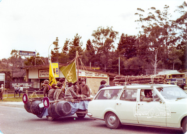
Photograph, !st Eltham Scouts and Cubs, Eltham Community Festival Parade, Main Road opposite Wingrove Park, 4 August 1978, 04/08/1978
Eltham Community Festival, 4-13 August 1978 Newsletter No. 3 September 1978 Eltham Community Festival. This year’s Eltham Community Festival was held from August 4th to 13th. The society was involved with the Warrandyte Historical Society in arranging an exhibition at the Community Centre and also provided notes and a map for a self-guided walking tour of historic buildings and locations around Eltham. Copies of notes will continue to be available from the Eltham Shire Offices and the tour may be under-taken at any time. The exhibition was divided into two sections. The Eltham Society displayed early photographs associated with the walking tour, whilst the Warrandyte Society showed their photographs and artefacts of the Warrandyte gold era. An outstanding feature was the large "blow-up" photos of early Warrandyte. Colour photographeltham, main road, eltham festival, alan whitmore estate agents, shell service station, mount pleasant road, parade, parade float, wingrove park, !st eltham scouts -
 Eltham District Historical Society Inc
Photograph, Montmorency Scouts, Eltham Community Festival Parade, Main Road opposite Wingrove Park, 4 August 1978, 04/08/1978
Eltham Community Festival, 4-13 August 1978 Newsletter No. 3 September 1978 Eltham Community Festival. This year’s Eltham Community Festival was held from August 4th to 13th. The society was involved with the Warrandyte Historical Society in arranging an exhibition at the Community Centre and also provided notes and a map for a self-guided walking tour of historic buildings and locations around Eltham. Copies of notes will continue to be available from the Eltham Shire Offices and the tour may be under-taken at any time. The exhibition was divided into two sections. The Eltham Society displayed early photographs associated with the walking tour, whilst the Warrandyte Society showed their photographs and artefacts of the Warrandyte gold era. An outstanding feature was the large "blow-up" photos of early Warrandyte. Colour photographeltham, main road, eltham festival, alan whitmore estate agents, shell service station, mount pleasant road, parade, parade float, wingrove park -
 Eltham District Historical Society Inc
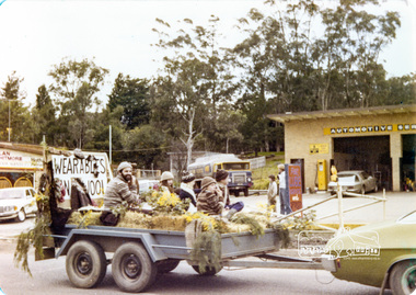
Photograph, Wearables Yarn Wool, Eltham Community Festival Parade, Main Road opposite Wingrove Park, 4 August 1978, 04/08/1978
Eltham Community Festival, 4-13 August 1978 Newsletter No. 3 September 1978 Eltham Community Festival. This year’s Eltham Community Festival was held from August 4th to 13th. The society was involved with the Warrandyte Historical Society in arranging an exhibition at the Community Centre and also provided notes and a map for a self-guided walking tour of historic buildings and locations around Eltham. Copies of notes will continue to be available from the Eltham Shire Offices and the tour may be under-taken at any time. The exhibition was divided into two sections. The Eltham Society displayed early photographs associated with the walking tour, whilst the Warrandyte Society showed their photographs and artefacts of the Warrandyte gold era. An outstanding feature was the large "blow-up" photos of early Warrandyte. Colour photographeltham, main road, eltham festival, alan whitmore estate agents, shell service station, mount pleasant road, parade, parade float, wingrove park -
 Eltham District Historical Society Inc
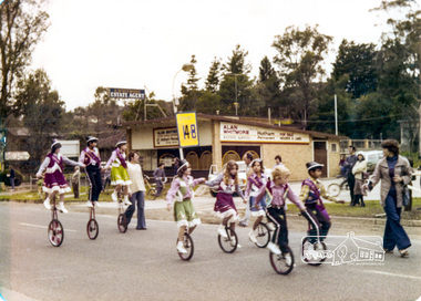
Photograph, Mono cyclists, Eltham Parade, Eltham Community Festival Parade, Main Road opposite Wingrove Park, 4 August 1978, 04/08/1978
Eltham Community Festival, 4-13 August 1978 Newsletter No. 3 September 1978 Eltham Community Festival. This year’s Eltham Community Festival was held from August 4th to 13th. The society was involved with the Warrandyte Historical Society in arranging an exhibition at the Community Centre and also provided notes and a map for a self-guided walking tour of historic buildings and locations around Eltham. Copies of notes will continue to be available from the Eltham Shire Offices and the tour may be under-taken at any time. The exhibition was divided into two sections. The Eltham Society displayed early photographs associated with the walking tour, whilst the Warrandyte Society showed their photographs and artefacts of the Warrandyte gold era. An outstanding feature was the large "blow-up" photos of early Warrandyte. Colour photographeltham, main road, eltham festival, alan whitmore estate agents, shell service station, mount pleasant road, parade, parade float, wingrove park -
 Eltham District Historical Society Inc
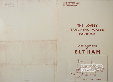
Photograph, For Private Sale in Subdivisions; The Lovely "Laughing Water" Paddock on the Yarra River at Eltham
Private sale of the "Laughing Water" paddock in subdivision; 5 river frontages with weatherboard villa on Lot 8; 6 woodland blocks of 5 and 6 acres. Sole Agent: Edward Haughton, 379 Collins Street, Melbourne Location plan and subdivision mapA3 colour photographic print from digital image of sales brochure and A4 reproduction of price listlaughing waters, edward haughton, real estate agent, eltham -
 Eltham District Historical Society Inc
Newsletter, Newsletter, No. 97 July 1994
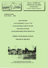
Contents: • Next meeting, Main Road, Eltham; Filling in the Map • July Meeting • The Shire of Eltham 1871-1994? • The New Eltham Library • The Warrandyte Mystery Tour May 29th 1994 by Bettina Woodburn • Should we do some forward planning on the past for the future? By Harry Gilham • Other News The Shire of Eltham Historical Society was formed in October 1967. The first newsletter of the Society was issued May 1978 and has been published continuously ever since on a bi-monthly basis. With the cessation of the Shire of Eltham in late 1994, the Society's name was revised to Eltham District Historical Society and this name first appeared with issue No. 103, July 1995. The collection of the Society's newsletters provides a valuable resource on the history of the Society's activities, office bearers and committee members, guest speakers and subjects of historical interest pertinent to the former Shire of Eltham and the Eltham District.A4 photocopied newsletter distributed to membersnewsletter, eltham district historical society, shire of eltham historical society -
 Eltham District Historical Society Inc
Newsletter, Newsletter, No. 98 September 1994
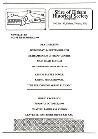
Contents: • Next meeting, Main Road, Eltham; Filling in the Map • July Meeting • The Shire of Eltham 1871-1994? • The New Eltham Library • The Warrandyte Mystery Tour May 29th 1994 by Bettina Woodburn • Should we do some forward planning on the past for the future? By Harry Gilham • Other News The Shire of Eltham Historical Society was formed in October 1967. The first newsletter of the Society was issued May 1978 and has been published continuously ever since on a bi-monthly basis. With the cessation of the Shire of Eltham in late 1994, the Society's name was revised to Eltham District Historical Society and this name first appeared with issue No. 103, July 1995. The collection of the Society's newsletters provides a valuable resource on the history of the Society's activities, office bearers and committee members, guest speakers and subjects of historical interest pertinent to the former Shire of Eltham and the Eltham District.A4 photocopied newsletter distributed to membersnewsletter, eltham district historical society, shire of eltham historical society -
 Eltham District Historical Society Inc
Newsletter, Newsletter, No. 129 November 1999
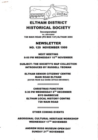
Contents: • Next meeting, The Society’s Map Collection; Introduced by Russell Yeoman • November Meeting • Christmas Function • Society Activities • Tarcoola Press • Museum Open Day • Aboriginal Cultural Heritage Workshop • The Shire of Eltham War memorial, Kangaroo Ground • Other News Items The Shire of Eltham Historical Society was formed in October 1967. The first newsletter of the Society was issued May 1978 and has been published continuously ever since on a bi-monthly basis. With the cessation of the Shire of Eltham in late 1994, the Society's name was revised to Eltham District Historical Society and this name first appeared with issue No. 103, July 1995. The collection of the Society's newsletters provides a valuable resource on the history of the Society's activities, office bearers and committee members, guest speakers and subjects of historical interest pertinent to the former Shire of Eltham and the Eltham District.A4 photocopied newsletter distributed to membersnewsletter, eltham district historical society, shire of eltham historical society -
 Eltham District Historical Society Inc
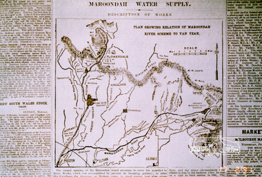
Photograph, Map showing the Maroondah system
Photograph of newspaper article (extract)maroondah dam, maroondah aqueduct -
 Eltham District Historical Society Inc
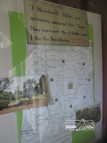
Photograph, Kangaroo Ground War Memorial Park: Photo display, 10 August 2016
Display in glass cabinet at the base of the stairs at the tower at Kangaroo Ground. 7 windmill palms are growing around the tower. They represent 6 states and 1 for the Territories with map and photo. As part of a program to acknowledge the Anzac Centenary Nillumbik Shire Council partnered with Yarra Plenty Regional Library to provide a bus tour with commentary of local sites of significance. These included Eltham township, the Shire of Eltham War Memorial at Kangaroo Ground, Christmas Hills, Hurstbridge memorial recreation park and finished at Eltham Library to view the Writing the War exhibtion at Eltham Library Community Gallery. Born Digitalworld war 1, war memorials, shire of nillumbik, heritage display, shire of eltham war memorial, kangaroo ground -
 Kiewa Valley Historical Society
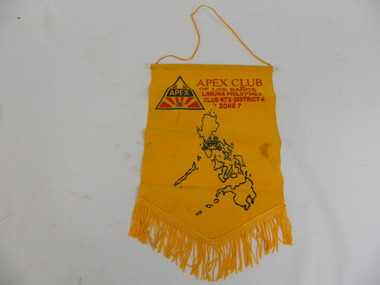
Banner & Pin - Apex Club
An Apex club existed in the Kiewa Valley. Apex clubs exchanged banners when a local member visited another club or when a member of another club visited the local club.Historical: Tas Davies belonged to the local Apex Club.Gold coloured flocked fabric banner with gold fringe at the bottom in triangular shape and cord on white plastic rod at the top. Gold coloured cord attached at each end of the rod to enable the banner to be hung. Apex gold pin attached - triangular logo on top of pin.Map of Philippines. Apex Club / of Los Banos / Laguna Philippines / Club 673.District 4 / Zone 7 Large red and green Apex logo. On pin: small red and green Apex logosocieties, clubs, community, service club, apex, banner, laguna, philippines, tas davies -
 Kiewa Valley Historical Society
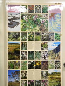
Map / Chart, Vegetation Map & Guide to Alpine Flora: Pretty Valley, 1982
This poster shows Pretty Valley is on the Victorian High Plains where the State Electricity Commission of Victoria worked on the Kiewa Hydro Scheme. Also cattle have grazed in the area over the years. This map is of interest to compare the flora in the area with times prior to 1982 and after 1982.This poster has historical and research value as it shows the flora in the pretty valley area therefore making it significant for people interested in plants. Also for those who would like to compare what plants are still in this area after 1982 and if the cattle grazing, climate change, of bush fires have had on the environment. Thus this poster also has good interpretive capacity of these reasons. Laminated double sided vegetation map and photographic guide to Alpine flora of the Pretty Valley areapretty valley. bogong. vegetation. plants. flowers. alpine. victorian high plains. cattle grazing. s.e.c.v. -
 Kiewa Valley Historical Society
Map / Chart, Vegetation Map & Guide to Alpine Flora: Hotham, 1982
This poster shows Mt Hotham is on the Victorian High Plains. This poster and map enables the comparison to be made of flora in other areas of the Victorian High Plains e.g.. which was previously known as the Bogong High Plains. This poster has historical and research value as it shows the flora in Mt Hotham area therefore making it significant for people interested in plants. Also for those who would like to compare what plants are still in this area after 1982 and if the cattle grazing, climate change, of bush fires have had on the environment. Thus this poster also has good interpretive capacity of these reasons.Laminated double sided vegetation map and photographic guide to Alpine flora of the Hotham area.hotham. vegetation. plants. flowers. alpine. high plains of victoria. -
 Kiewa Valley Historical Society
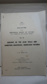
Document - Four Geological reports on the North-east Goldfields, Geological Survey of Victoria 1958 Bulletin
Geological Surveys of N.E. Goldfields Victoria included mines and tunnels. A resurvey of goldfields was necessary to re-assess economic possibilities using modern techniques and structural interpretation. It included an examination of a considerable surface area with maps and underground workings. Results were correlated and integrated and published by the Mines Department.The mines are in the Bogong Alpine Area.Foolscap printed Victorian Bulletins. Each stapled in the top left corner and each with varying number of pages. Covering 1941-1958 a) Glen Wills and Sunnyside b) Sunnyside Tunnel c) Red Robin d) Maud and Yellow Girl Government Printer, Mines Department, Melbourne, Victoriageology in the north-east, gold fields, goldmines, glen wills -
 Kiewa Valley Historical Society
Photos: Kiewa Hydro Electric Scheme x 12
K.H.E.S.Photos 4 coloured and 8 black and white with the Title printed below each one. 1. S.E.C.V. Telephone Switch Board (See also KVHS 0847) 2.West Kiewa Tunnel 3. Construction of Underground Power Station 4. Pretty Vally Camp 5.Outside Kiewa House, Bogong 6. S.E.C.V. Saucer (See also KVHS 0128) 7.Insulator Disk Struck by Lightning 8. S.E.C.V. Map of the Kiewa Hydro Scheme 9.Howman's Gap Camp 10.Tunnel Excavation Face 11. Mt Beauty Townhship 1948, looking north east 12. Mt Beauty Township - no labelkiewa hydro electric scheme photos -
 Kiewa Valley Historical Society
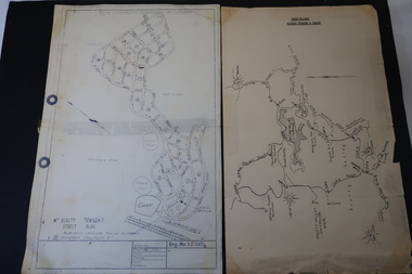
Maps - Bogong High Plains & Mt Beauty Township
The SECV continually updated their mapsDuring the development of the KHES the SECV had to continually update their mapsBoth Foolscap 1. Titled: High Plains Access Tracks & Roads 2. Mt Beauty Street Plan by SECV with Section Nos. and house numbersBoth have sticky tape marks on their back.khes maps -
 Kiewa Valley Historical Society
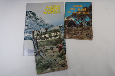
Books x3 - Walking on the Bogong High Plains, 1. The Alpine Track Walhalla to Mt Bogong. 2. Bogong High Plains and Adjacent Peaks both by John Siseman 3. Alpine Safety Manual
Books were published to guide walkers travelling long distances in remote areas increasing their safety and giving them independence.Bogong High Plains and Mt Bogong are at the upper end of the Kiewa Valley where local people and visitors spend their leisure time, walking.1. and 2. both written by John Siseman, small (pocket size), includes maps and black & white photos. The covers are colored photos with the title at the top. 1. has 78 pages and 2. has 63 pages.The Alpine Safety Manual (in yellow) is twice the size of the others and published by the Department of State Development, Decentralization and Tourism.It has 40 pages, coloured and black & white photos and is held by 2 staples.bush walking, bogong high plais, walhalla to mt bogong, alpine track -
 Kiewa Valley Historical Society
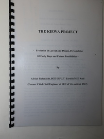
Booklet - The Kiewa Project, The Kiewa Project by Adrian Rufenacht
The Kiewa Hydro Electric Scheme was constructed by the SECVBooklet of 40 pages typed on both sides and including 4 maps at the back. It has a black plastic spiral spine and black back cover. Title on the front followed by 'Evolution of Layout and Design, Personalities / Of Early Days and Future Possibilities' followed by the authorkiewa hydro electric scheme, adrian rufenacht -
 Kiewa Valley Historical Society
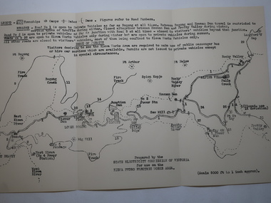
Map - Kiewa Hydro Electric Works Area
An early map of the Kiewa Hydro Electric Scheme Works Area prepared by the SECV for use when requesting access to the area. The regulations are printed regarding permits.During construction of the KHES there were restrictions on access to the area. This map identifies the land marks and states the regulations for entry to the area.Black and white map folded into three showing a legend with the townships, camps, gates and dams marked.Also indicating the roads, rivers, mountains and infrastructure of the KHES. khes works area, map of khes