Showing 1649 items
matching pilot
-
 Australian Gliding Museum
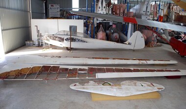
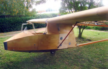
Machine - Glider - Sailplane, 1943
The Laister-Kauffman 10A (LK10A) is a 2 seat a military training glider developed from a successful Jack Laister single seat glider called Yankee Doodle that first flew in 1938 and was exhibited at the Paris Air Show of 1939. The two seater variation was ordered in 1941 by the US Army for training glider pilots of troop carrying gliders. The military designation was XTG-4. The LK 10A glider was a simpler, more robust design than Yankee Doodle. A longer canopy enclosed both seating positions. The top of the fuselage formed a straight ridge from the top of the canopy to the point where the fin – rudder connected. Also, the design was simplified by adopting straight spar wings of 15.2 metres in place of gull wings of 14.170 metres. During the war years 156 LK10As were produced before the contracts to supply the US Army were terminated. Many of these were later sold as surplus. The Museum’s exhibit (serial number 122) was built in 1943. It was imported into Australia in the 1950s by Ric New, a member of the Gliding Club of Western Australia. Ric New modified the glider by “flat topping” the fuselage and making other aerodynamic changes. This kind of modification of the LK10A was a well tried strategy in United States for extracting better performance from the glider. It is understood that the reduction in weight and cleaner aerodynamics from the changes could increase the glide ratio from 1:24 to something like 1:30. The LK10A was located at the Gliding Club of Western Australia for many years. Records reveal that it was kept airworthy until about 1975. The LK10A is an important acquisition in that it allows one to compare the state of two seat glider design in United States and the United Kingdom in the immediate post war period. It is interesting to note that at that time a number of clubs in Australia who acquired a two seat glider for training chose the United Kingdom open cockpit high strutted wing offerings from Slingsby (e.g. T31) instead of more innovative military surplus gliders from America. Modified LK10A glider consisting of tubular steel fuselage with a combination of fabric and metal covering, fabric covered wooden wings and other flying surfaces.australian gliding, glider, sailplane, laister, kauffman, ric new, gliding club of western australia, lk10a, yankee doodle, xtg-4 -
 Australian Gliding Museum
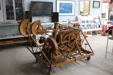
Machine - Winch - for auto tow launching cable laying and retrieval
The auto tow launching mechanism was designed by Ray Jamieson of Cobram in the north of Victoria. The prototype was built the for the Corowa Gliding Club where it was used for some years. After Ray’s brother, Bert Jamieson, had witnessed the machine in use at Corowa, at Bert’s request, Ray built second one (the Museum’s exhibit) for use at Bacchus Marsh airfield. Bert lived in Melbourne at the time and was a member of the Victorian Motorless Flight Group (VMFG) which used Bacchus Marsh airfield. This occurred in the 1970s. The method of operation was to have the auto tow mechanism mounted in the back of a utility motor vehicle. The launching cable was attached to the glider. With the Volkswagen engine of the mechanism running, the tow vehicle would then drive along the runway to commence the launch. The mechanism would automatically apply brake pressure to the cable drum as the vehicle proceeded freely letting out the cable and then smoothly towing the glider into the air. When the launching cable reached a certain angle, the pilot would release the cable from the glider at which point the winching mechanism would automatically retrieve the cable in preparation for the next launch. This allowed quicker restarts and the flexibility of easily changing runways to suit the wind conditions. It made gliding a simple and cost-effective operation. Ray Jamieson and his son often used the prototype which they named “George” at Corowa in this way. With the exception of several demonstration launches, the Museum’s example of this type of device was not used by the VMFG at Bacchus Marsh due to rulings by the Department of Civil Aviation encouraging the use of aero tow launching at their site. As far as is known this is the only device of its type in the world and is indicative of the ingenuity found amongst the Australian gliding fraternity.Single drum and motorized drive mechanism mounted on a mobile steel frame.australian gliding, glider, sailplane, auto towing, launching, jamieson, corowa gliding club, victorian motorless flight group, vmfg -
 Forests Commission Retired Personnel Association (FCRPA)
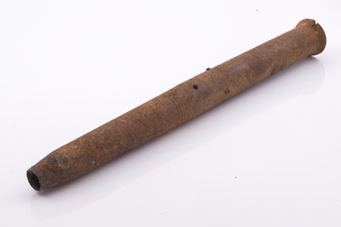
Splitting Gun, Black Powder
Black powder splitting guns were commonly used to split large logs into more manageable pieces before the advent of excavators and front-end loaders in bush logging operations. A typical splitting gun used in Victorian forests was a piece of high-grade steel about 1-1/2 to 2 inches in diameter and about 16 inches long, and slightly tapered at one end. They had a ¾ inch hole drilled about 9 inches deep into the centre of the shaft with a small pilot hole drilled from the outside to load the fuse. The tube was carefully loaded with an amount of black gunpowder using a funnel and spoon. Experience being the guide on how much powder to use, which depended on log size, species and difficulty of splitting the wood. The hole was stopped with a piece of wadded paper and the gun positioned at the end of a length of the log to be split. The splitting gun was then belted into the log with a large wooden maul or even the back of an axe to a depth of about 3 to 4 inches. There were often markings as a guide. This also had the effect of tamping the black powder inside the gun. Preferably the gun was backed up by another large log to absorb the shock and avoid it flying off in the bush somewhere. I have seen guns where a length of string and coloured flag could be attached to help find them. A length of fuse was then inserted in the small hole and lit. Kaboom !!!! Needless to say, the splitting gun was a dangerous implement.Commonly used to split pulpwood but now rareBlack Powder Splitting GunFive marking rings used to guide how far the gun was in the logforest harvesting -
 Chiltern Athenaeum Trust
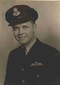
Photograph
Photo of Bluey Truscott. Squadron Leader Keith William (Bluey) Truscott was regarded as one of Australia’s most well known WW2 fighter pilot aces. He was born on the 17/5/1916 and died over Exmouth, Western Australia on 28/3/1943 in an Aircraft accident whilst on duty. He initially trained under the Commonwealth Empire Training Scheme In Canada at the beginning of WW2, and later on was posted to Number 452 Squadron England where he flew Spitfires over Europe. He was awarded the distinguished Flying Cross in 1941 for his Air action and bravery. In 1942 he was further awarded the DFC Bar for further outstanding Air action and bravery. He returned to Australia and commanded number 76 Squadron who undertook duties in Papua New Guinea, specifically Milne Bay. When with 76 Squadron they largely flew Kittyhawks. There is a club named after SQN LDR Truscott, called the Truscott Club, at Airforce Base Darwin. There is also a decommissioned WW2 Airfield in the Kimberley’s called after him ( Truscott Air Base). Truscott has more recently been called Mungalu-Truscott Air Base as it is now owned by the traditional people of the Wunambal Gaambera. The Airfield is now used for commercial and private flying and is heritage listed under the National Trust of Australia (W.A.) due to its historical significance relating to WW2 and the remaining artefacts that are still in place presently. Bluey Truscott was also a well known Australian Rules Football player prior to WW2 having played for Melbourne. Photograph of Keith William (Bluey) Truscott in uniform.ww2, bluey truscott, flying cross -
 Victorian Harness Racing Heritage Collection at Lord's Raceway Bendigo
Document - Record, Harness Horse, Avian Again
Stephen Spark compiled horses performance records starting in 1983 on his typewriter. Avian Again: Riverina Herald, Tuesday August 19, 1952 Mr Harry Holmfield's pacer Avian Again made a spectacular return to racing on Saturday night at Harold Park when he took one of the main races in ; his first appearance this season. Bookmakers were ready for his visit to Sydney for they did not bet better than 6/4 On. The Ech uca owned horse, driven by Gor don Rothacker, was never in danger and led almost through out to score comfortably by over one length. Sky Pilot, the N.Z. pacer, who has won his last three races at Harold Park, challenged at one stage but was easily beaten off. Mr Holmfield is very impress ed with trotting in Sydney where the attendances eclipse those at the galloping meetings in the day. Avian Again's race on Saturday night was worth ,£600—£450 to the winning own er. 'Next month there will be a race with six heats worth £700 each and £2500 for the final. It is likely that Avian Again in this race will strike his half-brother, the famous Avian Derby, who Has not been retired to the stud as expected. Next week Avian Again will race in the fastest class at Har old Park from the scratch mark. He has yet to appear at the. Melbourne Showgrounds and has been shrewdly placed. . Later in the season he will be taken to Perth where the Inter Dominion championships will, be held in February.Avian Again raced from 1951 (4yo) through to 1957 (10yo). Had a Winning Streak of 8 wins. Career: 31 wins 12 seconds 13 thirds 83 starts.Typed document in black and red ink.harness racing, australasian harness racing, horse career, performance records, bendigo harness racing club, bhrc, avian again, he holmfield, g rothacker, wc rothacker, gordon rothacker, bill rothacker, harry holmfield, gw rothacker -
 Department of Energy, Environment and Climate Action
Log Splitting Gun
Black powder splitting guns were commonly used to split large logs into more manageable pieces before the advent of excavators and front-end loaders in bush logging operations. A typical splitting gun used in Victorian forests was a piece of high-grade steel about 1-1/2 to 2 inches in diameter and about 16 inches long, and slightly tapered at one end. They had a ¾ inch hole drilled about 9 inches deep into the centre of the shaft with a small pilot hole drilled from the outside to load the fuse. The tube was carefully loaded with an amount of black gunpowder using a funnel and spoon. Experience being the guide on how much powder to use, which depended on log size, species and difficulty of splitting the wood. The hole was stopped with a piece of wadded paper and the gun positioned at the end of a length of the log to be split. The splitting gun was then belted into the log with a large wooden maul or even the back of an axe to a depth of about 3 to 4 inches. There were often markings as a guide. This also had the effect of tamping the black powder inside the gun. Preferably the gun was backed up by another large log to absorb the recoil shock and avoid it flying off in the bush somewhere. I have seen guns where a length of string and coloured flag could be attached to help find them. A length of fuse was then inserted in the small hole and lit. Kaboom !!!! Needless to say, the splitting gun was a dangerous implement.Log Splitting gun (large 50cm)forests commission victoria (fcv), hand tools -
 Department of Energy, Environment and Climate Action
Log Splitting Gun
Black powder splitting guns were commonly used to split large logs into more manageable pieces before the advent of excavators and front-end loaders in bush logging operations. A typical splitting gun used in Victorian forests was a piece of high-grade steel about 1-1/2 to 2 inches in diameter and about 16 inches long, and slightly tapered at one end. They had a ¾ inch hole drilled about 9 inches deep into the centre of the shaft with a small pilot hole drilled from the outside to load the fuse. The tube was carefully loaded with an amount of black gunpowder using a funnel and spoon. Experience being the guide on how much powder to use, which depended on log size, species and difficulty of splitting the wood. The hole was stopped with a piece of wadded paper and the gun positioned at the end of a length of the log to be split. The splitting gun was then belted into the log with a large wooden maul or even the back of an axe to a depth of about 3 to 4 inches. There were often markings as a guide. This also had the effect of tamping the black powder inside the gun. Preferably the gun was backed up by another large log to absorb the recoil shock and avoid it flying off in the bush somewhere. I have seen guns where a length of string and coloured flag could be attached to help find them. A length of fuse was then inserted in the small hole and lit. Kaboom !!!! Needless to say, the splitting gun was a dangerous implement.Log Splitting gun (large 45cm)forests commission victoria (fcv), hand tools -
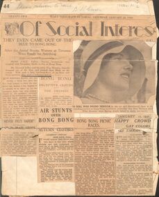 Bendigo Historical Society Inc.
Newspaper - HOWARD AND VIOLET JOLLEY COLLECTION: NEWSPAPER ARTICLES
From THE DAILY TELEGRAPH items include from Jan 18 & 10, 1930 Of Social Interest. THEY EVEN CAME OUT OF THE BLUE TO BONG BONG, After the air-stunts, Women at Tirranna Were Ready For Anything, Racing excitement mingled with aeroplane thrills at Bong Bong; Barbara Aird as passenger, Never felt safer; LADY IN PLANE STUNTS; Gypsy Moth; Howard Jolley and pilot Guy Menzies, Dick Allen DECEPTIVE CLOUDS; THE DRESSES; AIR STUNTS OVER BONG BONG; AUTUMN CLOTHES; BONG BONG PICNIC RACES Bachelors bag won by Orwell Phillips. Alan Binnie, Lady de Chair, Lt Graham de Chair, Miss Susan Spencer, Mr & Mrs Blomfield; HAPPY CROWD GAY COLOURS AT TIRRANNA, two men wore fly nets, Mrs Alan Binnie remarked at the state of the ground. Binnie family rider Jack Melville had to borrow plumes as his riding kit had displaced from the car's running board on route to the races. From MONDAY 11th Nov 1929, Croppa Creek picnic races, history as Messrs Jolley & Leggatt arrived by plane. From Sydney Morning Herald of 18/3/1930 The Town Hall was densely packed last night for the Irish national concert held in connection with St Patrick's Day celebrations with programme numbers drawing enthusiastic applause. -
NMIT (Northern Melbourne Institute of TAFE)
Report: Life skills and TAFE programs in Victoria, TAFE Board, 1985
A4 size report, aqua cover and various pagings, written in 1985. The primary aim of this project was to report to the TAFE Board, Victoria on the implementation of life skills material into mainstream vocational education at Royal Melbourne Institute of Technology (RMIT), with parallel emphasis on implementation models for statewide courses. The report is divided into 3 parts. Part A attempts to define the notion of life skills that developed from the work of Dr Stewart Sharlow’s ‘TAFE and basic life skills’, TAFE Services, Victoria, 1982 and the ‘Audit of TAFE middle level and technician humanities subjects,TAFE Services, Victoria, 1982. As a result of these publications a conference ‘Life Skills and the TAFE Practitioner’ was held in October, 1983 at Preston College of TAFE in Victoria with the aim of seeking a definition of the term life skill with regard to curriculum developments and classroom teaching. This report draws on these events and a number of programs developed or piloted in Victoria that are relevant to the issue. The report focuses on: 1. Work and Engineering Programme (RMIT,1984); 2. Diploma of Architectural Technology (RMIT); 3. Certificate of Law Enforcement Studies (RMIT); 4. Office and Secretarial Studies Certificate; 5. Life Skills at the Gordon College of TAFE; 6. Life Skills in the V.O.P. at Box Hill College of TAFE. Part B focuses on the experience of these activities towards curriculum and implementation needs, and evaluation and staff development requirements particular to these programs. Part C presents conclusions and recommendations.tafe board victoria, nmit -
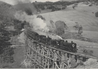 Wodonga & District Historical Society Inc
Photograph - Fred Rochow Railways Collection - Historical Special to Cudgewa, 3 November 1963
The Fred Rochow Railways Collection incorporates photos related to the operation of the Wodonga Railway Station including different types of trains and railways staff C. 1930 – 1990. It was donated to the Wodonga Historical Society by Fred Rochow, a railwayman who spent many years based in Wodonga. He joined the Victorian Railways on 17th June l947 and retired in 1988. For some time, he was a member of the Australian Federated Union of Locomotive Enginemen and served a term as a member of the Trades Hall Council. He had an extensive knowledge of the struggles that took place to achieve better conditions for railway workers. Fred worked for many years as a fireman and then worked his way up the ranks to driver, experiencing many changes from the days of steam locomotives through to diesel trains, locomotives and even the modern XPT train. He worked throughout Victoria at different stages of his career, with his final working years focused on the northeast of Victoria and the Albury to Melbourne line. After his retirement, Fred continued to share his love of steam miniature trains with the community. Cudgewa Line -The Cudgewa railway line opened in stages between 1889 and 1921. The first section from Wodonga to Huon opened on 10 September 1889. It was extended to Bolga on 18 July 1890, Tallangatta on 24 July 1891, Shelley on 13 June 1916 (the highest station in Victoria), Beetomba on 10 April 1919 and Cudgewa on 5 May 1921. In 1919, the line was used to carry materials for the construction of Hume Weir, and three years later a spur line connecting Ebden to the weir was opened. In the 1960s, Cudgewa became the railhead of materials for the Snowy Mountains Scheme. The last passenger service from Wodonga to Tallangatta ran on 30 September 1961 The turntable and passenger platform at Cudgewa were abolished in 1976.This collection has local and statewide significance as it captures images of trains, locomotives and personnel who operated the railway services in Wodonga and throughout Northeast Victoria. The railways played a critical role in opening up Victoria and connecting Australia for trade, business, social communication and transport.Historical Steam locomotive on journey to Cudgewa. Locomotive K184 leading with Driver Noel Strauss and Fireman Barrows. Locomotive K186 is the Banker with Driver Doug West. A banker is railway locomotive that temporarily assists a train that requires additional power or traction to climb a gradient. K Class Locomotives - One of VR's most successful classes of loco they were built over a 24 year period. A general purpose, light lines loco the K class had a very long career in all sorts of service from branch line passenger and goods work to pilot and banker duties and roadside mainline service. The K class is credited with working virtually every line in the VR system and hauling almost every kind of train. The majority of the class lasted into the 60's. K 184 and K186 were built by the Victorian Railways' Newport Workshops in 1945 to the successful K-class 2-8-0 locomotive design for branch-line work. K184 entered service on 9 January 1946. K186 entered service on 19 March 1946. K184 was used on heritage services with Steamrail Victoria through the 1970s. It was withdrawn from service in 1980 and is stored at Newport Workshops. and is now used as a source of spare parts; other Steamrail K Class locomotives occasionally wear its number plates and headlight number boards. K186 was scrapped on 25 October 1967.railways wodonga, fred rochow, cudgewa station, high country railway line, k class locomotives -
 Dandenong/Cranbourne RSL Sub Branch
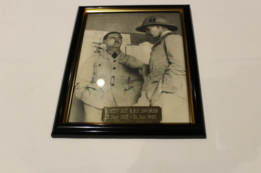
Photograph - Framed photo, Unknown
WWII Historical significance with some information of the Dandenong area.Black and white framed photo of 408537 Sgt R.R.E. Swords 23 Sep 1912 - 21 Jan 1943. This photograph is a tribute to the late Robert Richard Falkiner Swords. 'Bob' as he was known to his friends and most townsfolk of Dandenong and it's people. His older brother James, served in the First World War and later was a founding member of the Dandenong RSL Sub-Branch, formed in 1919, was its second President and also served a term as Honorary Secretary and Treasurer. James was the Editor of Dandenong's first newspaper, the Dandenong Advertiser. 'Bob' Swords was also a member of the Dandenong Advertiser newspaper and was a driving force in Dandenong getting it's own Hospital. For many years his photo hung over the entrance to the old building, which was demolished some years back. Regrettably this photo was lost. Bob enlisted into the Royal Australian Air Force to train as a pilot on 26 April 1941 and after initial training embarked to Southern Rhodesia. After completion of initial flight training he then moved to England for advanced training, prior to postings onto an OTU. He was tragically killed during this phase of training on 21 January 1943. The gentleman with in this photo is believed to be his South African Flying Instructor 'Panda' Watkins. His grave in England has a lovely headstone and the inscription: 'Service Above Self'. (As advised by Robert Richard Kudyba OAM).Brass plaque stating 4085537 Sgt R.R.F. Swords 23 Sept 1912 - 21 Jan 1943. -
 Bendigo Military Museum
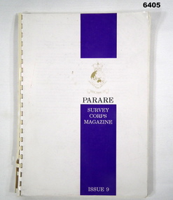
Magazine - "Parare" Survey Corps Magazine Issue 9, Royal Australian Survey Corps, 1993
An annual magazine published for release on RASvy Corps birthday 1st July. All units with RASvy Corps are invited / expected to submit an article depicting their activities over the preceding years 1991 to 1993. 4Fd Svy Sqn Adventure training list pages 7, 8. Army Map Depot - Unit Ski Day, pages 20, 21. The William Patton Expedition - Locating his grave as part of the " Burke and Wills " expedition, list of personnel involved - page 43. 8 Fd Svy Sqn - names mentioned and photo - page 50. 4 Fd Svy Sqn (1992) names mentioned page 69. The G Res manning list on page 70. Names mentioned in "Unit sports pages 73, 74. Exercise Kokoda Cartographer July 1992 list of participants on Page 78. Iraq - The Gulf War, Topographic Support page 52. Adelaide (4 Fd Svy Sqn) 1992 page 65. 8 Fd Svy Sqn manning wind down list pages 89-90. Military Geographic Information Pilot Project page 92. Royal Australian Survey Corps Aerial photography Team personnel list page 95. Operation Belama 92 Team list page 96. Long term Schooling attendees and promotions, page 105. Litho Sqn Postings in and out pages 116-117. Special awards SGT Durrant page 113, SSGT SR Hill page 114. RASvy completes 1:50,000 scale mapping of the Pilbara Region page 121. 1st Topo Svy Sqn personnel mentioned on page 122. A4 sized booklet with soft glossy card covers, paper pages held together with a plastic spiral binder.army survey regiment, army survey regt, fortuna, royal australian survey corps, rasvy, asr -
 Mission to Seafarers Victoria
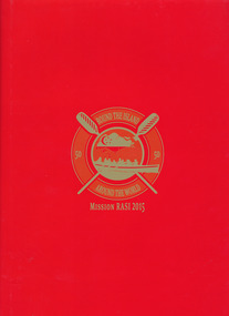
Book, Mission to Seafarers, Round the Island- Around the World - Mission RASI 2015, 2015
"In connection with the SG50 celebrations in Singapore, Mission RASI (Row Around Singapore Island) will see a team of Singaporeans join hands with friends from overseas in a test of endurance and teamwork, to raise funds to further the Mission's work in promoting good shipping practices and a safe working environment for seafarers"--Page 4.Red cardboard hard cover book with red paper outer sleeve. 55 pages : color illustrations, color map ; 31 cmnon-fiction"In connection with the SG50 celebrations in Singapore, Mission RASI (Row Around Singapore Island) will see a team of Singaporeans join hands with friends from overseas in a test of endurance and teamwork, to raise funds to further the Mission's work in promoting good shipping practices and a safe working environment for seafarers"--Page 4.mission to seafarers, worldwide, charity, volunteers, singapore, nigel porteous, andrea fleming, london, rasi, row around singapore island, 2015, fundraising, reverend andrew wright, mts london, mts singapore, rowing -
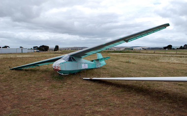
 Australian Gliding Museum
Machine - Glider – Sailplane, March 1964
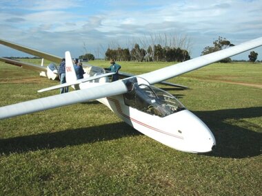
The Schleicher K7 is a high wing tandem two-seat sailplane designed in the late 1950s by Rudolf Kaiser for the Alexander Schleicher company in Germany. The fuselage is built using steel tube framing covered with fabric. The swept-forward cantilever wing is of wood and fabric construction with a single spar and a plywood covered leading edge “D” box for strength. The wing is equipped with Schempp-Hirth airbrakes. The K7 first flew in 1959. It is a versatile design that can be used for both basic and more advanced training of pilots. Over 500 were built. VH-GNX was manufactured in Germany and imported into Australia by Edmund Schneider Limited. It was test flown by them at Parafield Aerodrome, Adelaide, South Australia in March 1964. The original owner of VH-GNX was the Adelaide Soaring Club and it was maintained by Edmund Schneider Limited until May 1971. It appears that about this time it was transferred to the Gold Coast Soaring Club. In July 1974, after it had flown for an aggregate 3075 hours from 13919 flights, it was purchased by the Bundaberg Soaring Club. About 10 years later, it was acquired by the Bendigo Gliding Club. At that stage it had recorded over 4600 hours flying time from 21546 launches. When it was retired from service by the Bendigo Gliding Club in June 2006 due to age related defects the hours flown had reached 7259 from 31820 flights. It appears that the airframe has had a relatively trouble free life with only minor damage from storage / ground handling incidents, a heavy landing (January 1987) and a bird strike (January 2002). It was donated to the Museum in April 2007.This exhibit is an example of the Schleicher K7 two seat sailplane type.Two seat high wing glider sailplane finished in white with red detailing.Serial Number 7134, registered as VH-GNX. The registration appears on each side of the Fin / Rudder in red letteringaustralian gliding, glider, sailplane, schleicher, k7, schneider, adelaide soaring club, gold coast soaring club, bundaberg soaring club, bendigo gliding club -
 Australian Gliding Museum
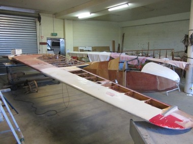
Machine - Glider – Sailplane, 2015
The Salamandra is a Polish glider designed by Waclaw Czerwinski at the Military Glider Workshops in Krakow in 1936. This glider, designated “W.W.S.1”, was produced in substantial numbers prior to the second world war and used in Poland and some other eastern European countries for training pilots. Only one example survived the war, hidden away in the village of Goleszow in Silesia. In addition, no technical drawings could be found, so when the glider was discovered, the Gliding Institute being keen to re-establish gliding in Poland, used the glider to draw up new plans for construction. Five were built for the Institute in 1947 before production was resumed of the “Salamandra 48” at the SZD Jezow Workshops. Improvement were made by adding airbrakes and structural changes for the “Salamandra 49” and a windscreen and larger tailplane were changes adopted for the “Salamandra 53”. An export version designated “53A” was sold to and built under licence in China. Production of the Salamandra ceased in the early 1960s. Total production may have been in excess of 500. The glider was well regarded as a light weight trainer capable of soaring performance. The Museum’s replica was built by Ray Ash and may be may be classified as a “Salamandra 53”. However, he has added something of his own to the design by replacing the cable runs in the wings with control rods. The glider is substantially complete. The wings and tail / rudder surfaces have been covered with poly-fibre fabric. The fuselage woodwork is sealed with varnish. In addition to the finishing work (including painting) and rigging of the main components, the linkages for Ray’s control rod modification may need further engineering to make them operational. The Ray Ash Salamandra is the first of the type to appear in Australia. The Salamandra did not play any role in the development of gliding in Australia in the early years. However, it is an important exhibit in that it shows in tangible form a nacelle fuselage training glider in configuration and construction detail. As such it revisits the pioneering era of the 1930s and 1940s in Australia when wood, wire and fabric were the rule and the nacelle primary glider was generally the first step up for pilots who had mastered the basics in an open primary.Nacelled solo training glider of traditional wood and fabric construction. Construction incomplete.Noneaustralian gliding, sailplane, glider, salamandra, czerwinshi, poland, ash -
 Australian Gliding Museum
Machine - Glider / Sailplane
The exhibit is the prototype Kingfisher Mark 1 (serial number 23) built by Edmund Schneider Ltd and first flown on 8 July 1956. It was first registered as VH-GDH on 3 May 1957. The ES57 Kingfisher is a small to medium size single seat glider that was designed to have similar control responses to the successful two seat trainer, the ES 52 Kookaburra, thus providing for a smooth transition for solo rated pilots to advance to a single seat machine. Edmund Schneider Ltd built nine Kingfishers and supplied kits for two more for construction by others. Harold Bradley (South Australia) built a modified Kingfisher with shoulder mounted wings. Kingfisher serial number 23 was originally owned by the Waikerie Gliding Club (South Australia) (1956 – 1959). From 1959, it had a nomadic existence in the hands of a string of owners in New South Wales, Queensland, Northern Territory and finally Queensland, again. In the early 1990s the glider was deregistered and flown as an ultralight sailplane. After a change in ownership, the glider was moved to Hervey Bay, Qld and re-registered as VH-GKN. After very limited use, the glider was sold again and placed in storage at Hervey Bay. In January 2004, the owner, who by then had moved overseas, entrusted the glider to Ian Patching and Geoff Hearn who moved it to Melbourne. Ian Patching returned the glider to flying condition in February 2004. Since then, it has been stripped and recovered with new aircraft fabric and requires finishing work. The logged hours flown for the Kingfisher total approximately 190 hours from 549 flights. The glider was donated to the Australian Gliding Museum on 3 June 2014.The Exhibit is one of the Edmund Schneider Ltd gliders that was designed and built in Australia in the late 1950s. It is one of the four Kingfishers that are known to survive – the Bradley Kingfisher and two of the standard Kingfishers are known to have been destroyed – the fates of five are unknown. Single seat high wing wooden sailplane with plywood and fabric covering, in a partly restored condition. Serial number 23australian gliding, glider, sailplane, es 57, kingfisher, patching, schneider -
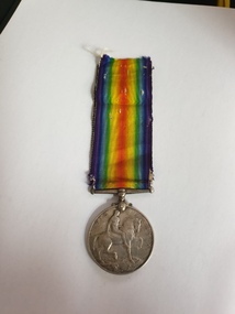 Clayton RSL Sub Branch
Medal, cc 1920's
Instituted by King George V in 1919 to mark the end of World War I and record the service given. The British War Medal 1914-20 was awarded as follows: Navy: 28 days mobilised service in Australia, at sea or overseas during prescribed periods. Army: Entered theatres of war during specified periods or left places of residence and rendered approved service overseas. Mercantile Marine: Awarded to the men and women of the Mercantile Marine who served at least six months at sea between 4th August 1914 and 11th November 1918. Licensed Pilots, Fishermen and crews of Pilotage and Lighthouse Authorities' Vessels, and of Post Office Cable Ships were also eligible. Those eligible also included members of women's organisations; persons on the staffs of military hospitals and members of recognised organisations who handled sick and wounded; and members of other duly recognised or other authorised organisations as specified in medal regulations. The qualification period of service between 5 August 1914 and 11 November 1918 was later extended to cover post-war mine clearance and service in Russia during 1919 and 1920. The ribbon has a wide central watered stripe of orange, flanked by two narrow white stripes, which are in turn flanked by two black pin-stripes, further flanked by two outer stripes of blue. The colours have no particular significance. The medal is cupro-nickel with the effigy of George V on the obverse. The reverse has an image of St George on horseback trampling underfoot the eagle shield of the Central Powers, and a skull and cross-bones, the emblems of death. Above this is the risen sun of victory. The years 1914 and 1918 are contained on the outside edge medal.GEORGIVS V BRITT OMN:REX ET IND:IMP: 2186 FRASER, Thomasbritish war medal, medal, first world war, world war one, ww1 -
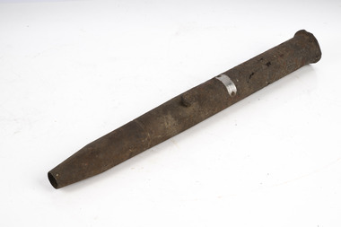
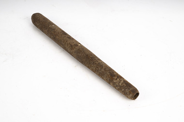
 Forests Commission Retired Personnel Association (FCRPA)
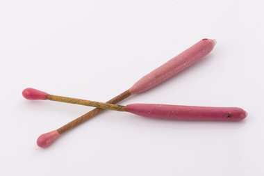
Delayed Action Incendiary Device (DAID), Bryant and May - Richmond, Large double ended match
The Forests Commission developed the use of helicopters for aerial ignition from the mid 1960s. Bryant and May at Richmond worked with the Commission to develop a Delayed Action Incendiary Device. DAIDs as the were known, had an overall length of 180 mm, striker end length - 10 mm. Ignition end length - 80 mm, then a layer of high melting point wax (to prevent accidental ignition when rubbing together in transit). Both ends coated with a modified match head compound with safety fuse exposed length between coated match ends. There was a 17-second delay from when the small end was struck to an intense flaming of the large end, which lasted for 40 seconds. DAIDs were dangerous so were stored in a metal box outside the helicopter along with a disposable striker patch attached with a quick release pin to a special half-door. The first test was with a Bell 47G on 4 October 1967 and the first use, anywhere in the world, of DAIDs to backburn a large bushfire was undertaken in north eastern Victoria in February 1968. There was a crash of an FCV helicopter conducting aerial ignition near Wandiligong on 19 April 1978 with the tragic death of two forest officers and their pilot. The crash led to the immediate end of the use of DAIDs and the adoption of the safer Premo ping-pong ball incendiary machine which originally came from Canada but was modified at the Altona workshops. Overall, the development of aerial ignition techniques by the Forests Commission from the mid-1960s resulted in a steady climb in the area burnt each year…. peaking at 477,000 ha in 1980-81 and with an impressive 10-year rolling average of 220,000 ha around the time of 1983 Ash Wednesday Bushfires.Developed in Victoria for aerial ignitionLarge double ended match used for aerial ignition and back burning by dropping from a helicopterbushfire, forests commission victoria (fcv) -
 Mission to Seafarers Victoria
Painting - Oil painting, Madeline M.Ravenna Lewellin, Start Point Light, Devonshire, 1875
This painting was inspired by an original painting by Wilhelm Melby held at the National Gallery of Victoria. Melby is a Danish artist (1824-1882). It depicts a famous Devonshire coastal region famous now for its lighthouse and the pick up point for the pilot when entering waters approaching Dartmouth. The sailing vessels pre-date the construction of the famous lighthouse. Over the centuries the view would have been familiar to many sailors as they left or approached the English mainland and south coast ports in the English Channel. Madeline Mary Ravenna Lewellin (1854 – 24 November 1944) was born in Victoria to Dr John Henry Hill Lewellin, a physician, and Grace Elizabeth (née Danneby). She was one of five daughters, and the family lived in Prahran. Lewellin's brother, Captain Herbert Gordon Hill Lewellin, was a commander in the P. and O. fleet (apprentice on the Romanoff, Lieutenant RNR on the HMS Arethusa in 1899, RMS Mongolia in 1913 sunk in 1917, Naldera in 1920). She studied painting at the National Gallery School in 1879 under Eugene von Guerard. She's also known for collecting and painting specimens, and became a member of the Field Naturalists Club of Victoria in 1885. In 1884 she won a silver medal for her studies of fungi. She collected plants for Australian botanist Ferdinand von Mueller, and the variety of Dicrastylis lewellinii (Purple sand-sage) is named after her. Miss Lewellin, who had a love of the sea and ships as subject matter is listed in 1910 as a donor as a 10/6 member donating to the motor launch fund and in 1918 as a working member of the Ladies Harbour Lights Guild which involved regular volunteer shifts at the Mission to Seamen on canteen and other duties.Marine art, Maritime artThis oil painting has a dark polished wood and gold leaf slip. The painting depicts two masted boats. The choppy sea takes up the lower-third of the painting, and the other two-thirds of the image of made up of stormy grey clouds. A rocky cliff face can be seen on the right-hand side of the painting. A small church can be seen on the hillside. The ship on the left third of the painting sits on the horizon line of the sea. The centre ship with two masts appears to be leaning to the right and its deck is exposed to the viewer showing four men attempting to handle the masts and rigging. The left-hand ship with three masts is surrounded by two grey distant silhouetted mast ships. There are three seagulls at the upper left-centre of the image. There are another three gulls down on the lower-left of the image. Front: ENGRAVED PLAQUE: Start Point Light. Devonshire. SIGNATURE: After W. Melby / M.M.R Lewellin. 1875. Reverse: IN BLACK MARKER PEN: * Hang from two points * WHITE STICKER WITH CONSERVATOR DETAILS: Art Conservation Frames / 118 Bridport Street, Albert Park, VIC, 3206 / 9696 9066 / artconservationframers.com.aupainting, ships, mast, church, sea, storm, oil painting, seagulls, madeline r. lewellin, artwork-paintings, ngv, wilhelm melby, eugene von guerard, botanist, rms mongolia, captain herbert gordon hill lewellin (1862-1935), paddy lewellin, reproduction -
 Department of Energy, Environment and Climate Action
Delayed Action Incendiary Device (DAID)
The Forests Commission developed the use of helicopters for aerial ignition from the mid 1960s. Bryant and May at Richmond worked with the Commission to develop a Delayed Action Incendiary Device. DAIDs as the were known, had an overall length of 180 mm, striker end length - 10 mm. Ignition end length - 80 mm, then a layer of high melting point wax (to prevent accidental ignition when rubbing together in transit). Both ends coated with a modified match head compound with safety fuse exposed length between coated match ends. There was a 17-second delay from when the small end was struck to an intense flaming of the large end, which lasted for 40 seconds. DAIDs were dangerous so were stored in a metal box outside the helicopter along with a disposable striker patch attached with a quick release pin to a special half-door. The first test was with a Bell 47G on 4 October 1967 and the first use, anywhere in the world, of DAIDs to backburn a large bushfire was undertaken in north eastern Victoria in February 1968. There was a crash of an FCV helicopter conducting aerial ignition near Wandiligong on 19 April 1978 with the tragic death of two forest officers and their pilot. The crash led to the immediate end of the use of DAIDs and the adoption of the safer Premo ping-pong ball incendiary machine which originally came from Canada but was modified at the Altona workshops. Overall, the development of aerial ignition techniques by the Forests Commission from the mid-1960s resulted in a steady climb in the area burnt each year…. peaking at 477,000 ha in 1980-81 and with an impressive 10-year rolling average of 220,000 ha around the time of 1983 Ash Wednesday Bushfires.Developed in Victoria for aerial ignition by the FCV and Byant & MayLarge double ended match used for aerial ignition and back burning by dropping from a helicopterforests commission victoria (fcv), bushfire, planned burning -
 Bendigo Military Museum
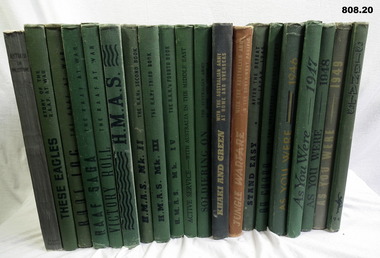
Literary work - BOOK SET, Australian War Memorial Set of 20, 1) 1919; .2) & .6) 1942; .3) & .12) 1943; .4), .7), 8), &.16) 1953; .5), .9) & .14) 1945; .10) 1941; .11) & .20) 1954. .13) & .14) 1944;
Set of Books commonly called 'As You Were' from WW1 and WW2. Green cloth. .1) Australia in Palestine (WWI) Book, hard cover, cardboard in centre of cover is silhouette of a Light Horseman & horse. Print is black ink, 153 pages. Illustrated with photos, drawings & maps. .2) These Eagles. Story of the RAAF at War. Book, green hard buckram cover, 200 pages. Front cover has black print with outline drawing of an eagle. Illustrated with photos, drawings. .3) RAAF Log - The RAAF at War. Book, green buckram hard cover. Front has profile of a pilot, black print, 200 pages, illustrated with photos, maps. paintings & drawings. .4) RAAF SAAG - The RAAF at War. Front cover has drawing of 2 Fighter Pilots in black ink, black print. 200 pages, illustrated with photos, drawings & paintings. Book, green buckram hard cover. Front cover has drawing of 2 Fighter pilots, black print, 200 pages, photos, drawings & paintings. .5) Victory Roll - The RAAF at War. Book, green buckram, black print, 200 pages, photos, drawings & charts. .6) HMAS Green buckram hard cloth cover, cloth cover with black text. 200 pages, black & white print, black text on white paper. .7) HMAS Mk II. Book, green buckram hard cover, black & white text on white paper. 200 pages, illustrated colour prints. .8) HMAS Mk III Book , green buckram hard cover, black text on white paper. 200 pages, illustrated colour prints. .9) HMAS Mk IV Book, green buckram hard cover, black text on white paper. Illustrated colour prints. .10) Active Service with Australia in the Middle East. Book, green buckram hard cover, black text on white paper, 129 pages. .11) Soldering on the Australian Army at Home & Overseas. Book, green buckram hard cover, black text on white paper, 200 pages. Rising Sun badge at bottom right hand corner. Illustrated with black & white photos, paintings, maps & drawings. .12) Khaki & Green with the Australian Army at Home & Overseas. Book, green buckram hard cover, black text on white paper, 204 pages. Front cover has a layout of words khaki & green, 2nd tone in light yellow. Illustrated with black & white photos, paintings, & drawings. .13) Jungle Warfare with the Australian Army in the South West Pacific. Book, brown buckram hard cover, light brown ink. Image at bottom of Australian soldier in jungle, 208 pages. Illustrated with photos, paintings, maps & drawings. .14) Stand Easy. After the Defeat of Japan, 1945. Book, light green buckram hard cover, black text on white paper, 208 pages. Image of soldier, both arms outstretched, smiling. Illustrated with photos, maps, paintings, & drawings. .15 On Guard with the Volunteer Defence Corps. Book, green & black buckram hard cover, black text on white paper, 172 pages. Illustrated with colour prints, & black & white photos. .16) As You Were. A Cavalcade of Events with The Australian Services from 1788 to 1946. Book, green buckram hard cover, tan & black text on white paper, 202 pages. Illustrated with black & white photos & colour prints. .17) As You Were. A Cavalcade of Events with The Australian Services from 1788 to 1947. Book, green buckram hard cover, black text on white paper, 202 pages. Illustrated with black & white photos & colour prints. .18) As You Were. A Cavalcade of Events with The Australian Services from 1788 to 1948. Book, green buckram hard cover, black text on white paper, 202 pages. Illustrated with black & white photos & colour prints. .19) As You Were. A Cavalcade of Events with The Australian Services from 1788 to 1949. Book, green buckram hard cover, green text on white paper, red & green diagram, 194 pages. Illustrated with black & white photos & colour prints. .20) Signals. Story of the Australian Corps of Signals. Book, green buckram hard cover, black text on white paper, 196 pages. In the corner of the front cover is the badge with motif of the Australian Corps of Signals. Illustrated with photos & drawings..1) 4214 TPR J E Neilson Year 1919 F E Addlem 1962 .books-military, museums, history -
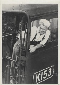 Wodonga & District Historical Society Inc
Photograph - Fred Rochow Railways Collection - Driver George Sandford, C. 1970s
The Fred Rochow Railways Collection incorporates photos related to the operation of the Wodonga Railway Station including different types of trains and railways staff C. 1930 – 1990. It was donated to the Wodonga Historical Society by Fred Rochow, a railwayman who spent many years based in Wodonga. He joined the Victorian Railways on 17th June l947 and retired in 1988. For some time, he was a member of the Australian Federated Union of Locomotive Enginemen and served a term as a member of the Trades Hall Council. He had an extensive knowledge of the struggles that took place to achieve better conditions for railway workers. Fred worked for many years as a fireman and then worked his way up the ranks to driver, experiencing many changes from the days of steam locomotives through to diesel trains, locomotives and even the modern XPT train. He worked throughout Victoria at different stages of his career, with his final working years focused on the northeast of Victoria and the Albury to Melbourne line. After his retirement, Fred continued to share his love of steam miniature trains with the community.This collection has local and statewide significance as it captures images of trains, locomotives and personnel who operated the railway services in Wodonga and throughout Northeast Victoria. The railways played a critical role in opening up Victoria and connecting Australia for trade, business, social communication and transport.Driver George Sandford on Locomotive K153 George joined Victoria Railways on 4th June 951. He started cleaning at Seymour on 21 February 1955. George passed his Driver qualification on 18 May 1960. He was based at Cressy from 1966 to 1968 followed by Wodonga from 1966 to 1982. K Class Locomotives - One of VR's most successful classes of loco they were built over a 24 year period. A general purpose, light lines loco the K class had a very long career in all sorts of service from branch line passenger and goods work to pilot and banker duties and roadside mainline service. The K class is credited with working virtually every line in the VR system and hauling almost every kind of train. The majority of the class lasted into the 60's. K153 entered service on 9 September 1940, initially allocated to the Benalla locomotive Depot It is now owned by VicTrack and managed by Steamrail Victoria. When in Melbourne, it is regularly used on suburban shuttles and on day tours to Geelong and similar-length trips. At various stages it has been withdrawn from service for preservation work. Throughout its preservation career (starting from 1974), the engine has been painted all-over black with some details picked out in white or yellow (such as handrails and the staff exchanger horn, welded in the raised position) to meet modern safety standards. It most recently returned to service in 2003.railways wodonga, fred rochow, wodonga railwaymen, george sandford, locomotive k153 -
 Bendigo Historical Society Inc.
Document - NEW CHUM RAILWAY MINE - GOLD MINES OF BENDIGO & EAGLEHAWK
Handwritten notes, and typed copy of same, on the New Chum Railway Mine and other mines and connections between various mines underground. Descriptions of mines and their equipment. Mines mentioned are: New Chum Railway Mine, Eureka Extended, Shenandoah, Shamrock Mine, Young Chum, Old Chum, Little Chum, New Chum Tribute, Cravens, Garibaldi, New Chum Consolidated, Menzies, Ellesmere, Consolidated, Denis, Lansell's 222, New Chum United, Kochs & Hildebrandt Mine, Lazarus, Central Blue, Lazarus No 1 Coy, Hudson's, Burrows & Sterry, Victoria Tribute, North Old Chum, Lansell's Big 180, Sandhurst, Victoria Quartz, The Great Central Victoria (known as the 'Midway'), Victoria Consols, Advance, Adventure, Ironbark, Victoria Gold Mines Company, No 83 claim, The Hercules & Energetic, North Energetic, Victoria Pilot, Bendigo Amalgamated Goldfields Company, Pearl, Hercules No 1, Hercules New Chum, Great Extended Victoria, New Victoria Catherine, Mystery (later the Duke of Edinburgh), New St Mungo, Duchess Tribute, Extended South Devonshire, South Devonshirte, Duchess of Edinburgh, Princess Alexandia (later United Devonshire), Danes, United Devonshire, South Devonshire, Hopewell, Phoenix, Unicorn, Lady Barkly, Sadowa, Eastwood Lease, Ellenborough, Belmont & Saxby, York & Durham, Acadia, Williams United, Ulster, North Red White & Blue, North Deborah, Catherine Reef United, Central Catherine, Princess Alice, Catherine Reef United, Murchison, North Catherine (or Franklin), Catherine Reef Extended,document, gold, gold mines of bendigo & eaglehawk, new chum railway mine, gold mines of bendigo & eaglehawk, eureka extended, shenandoah, shamrock mine, young chum, old chum, little chum, new chum tribute, cravens, garibaldi, new chum consolidated, menzies, ellesmere, consolidated, denis, lansell's 222, new chum united, kochs & hildebrandt mine, lazarus, central blue, lazarus no 1 coy, hudson's, burrows & sterry, victoria tribute, north old chum, lansell's big 180, sandhurst, victoria quartz, the great central victoria (known as the 'midway'), victoria consols, advance, adventure, ironbark, victoria gold mines company, no 83 claim, the hercules & energetic, north energetic, victoria pilot, bendigo amalgamated goldfields company, pearl, hercules no 1, hercules new chum, great extended victoria, new victoria catherine, mystery (later the duke of edinburgh), new st mungo, duchess tribute, extended south devonshire, south devonshirte, duchess of edinburgh, princess alexandia (later united devonshire), danes, united devonshire, south devonshire, hopewell, phoenix, unicorn, lady barkly, sadowa, eastwood lease, ellenborough, belmont & saxby, york & durham, acadia, williams united, ulster, north red white & blue, north deborah, catherine reef united, central catherine, princess alice, catherine reef united, murchison, north catherine (or franklin), catherine reef extended, mr clark magee, john delbridge - engineers, a harkness & sons, mr lansell, b c v 8 studios, mr gibbs, mr barnet lazarus, mt alvernia hospital, p m g repeater station, john brown knitwear, mr burrows, mr sterry, john wybrants, mr wittschiebe, theodore ballerstadt, mr wm rae, california hill state school, freeman & coy -
 Flagstaff Hill Maritime Museum and Village
Financial record - Bank Deposit Book, Commercial Banking Company of Sydney Limited, Pre Jan, 1932
This bank deposit book was used for financial deposits made between1932 and 1936. The funds were deposited into the Emergency Account of the Warrnambool Harbour Board, lodged at the Warrnambool Branch of the Commercial Banking Company of Sydney Limited (CBC). James Menzies, Pilot and Harbour Master from 1929, would have used this deposit book when he was appointed as Acting Secretary of the Warrnambool Harbour Board in 1932. He held this office until the Board ceased in 1936. Warrnambool’s CBC Manager during this time was L E Whitney; he was Manager from 1924 to 1939. The Commercial Banking Company of Sydney Limited opened in 1893. On January 1, 1927 the CBC amalgamated with the Bank of Victoria. In 1981 the CBC merged with the National Bank of Australasia Limited and on January 1, 1983 the bank started using the abbreviated name of the National Australia Bank (NAB). Warrnambool Harbour Board The Warrnambool Harbour Board was constituted by Order of Council on May 29, 1928, under the Harbour Board’s Act of 1927, taking over from the Ports and Harbours Branch of the Public Works Department of Victoria. The Board was then the only body with power to manage and control the whole Port, including shipping, facilities upkeep and improvements of the port. The work it carried out involved dredging, building of port facilities and drafting of port regulations, and collecting taxes, tolls, rates and charges. The Board was officially dissolved on June 30, 1936, at which time the Public Works Department again had control. The Warrnambool Harbour Board had rented out the Lighthouse Keeper’s Quarters from the 1920s until 1936, when the Board closed down. However, rentals continued with other currently unknown landlords until Flagstaff Hill Maritime Village opened in 1975 and began renovating the Cottage, in stages. This financial record book is significant for its association with the historic financial records of the Warrnambool Harbour Board and relates to the maritime history of Warrnambool, in particular with the Port of Warrnambool.Warrnambool Harbour Board Emergency Account Book containing deposit receipts and blank forms for the Commercial Banking Company of Sydney Limited. Rectangular book has buff coloured card covers, white pages with pre-printed text and lines and black tape binding on left side. Inscriptions stamped on front cover, receipts and unused, pre-printed pages. Approximately half of the pages have been filled in, and the deposit slips removed, leaving the receipt end attached to the book. There are two lose receipts stapled into the book. Hand written receipts date from 21 JAN 1932 to 25 JULY 1936. Stamped "WARRNAMBOOL HARBOUR BOARD / EMERGENCY ACCOUNT" "WARRNAMBOOL VIC" "EMERGENCY ACCOUNT / WARRNAMBOOL HARBOUR BOARD" Also, each receipt has the bank's stamp with its details and the date on it. Hand written details are on each completed receipt.warrnambool, shipwrecked-coast, flagstaff-hill, flagstaff-hill-maritime-museum, maritime-museum, shipwreck-coast, flagstaff-hill-maritime-village, shipwrecked-artefact, book, warrnambool harbour board, emergency account, commercial banking company os sydney ltd, bank deposit book, financial record, financial management, stationery, deposit book, public works department, ports and harbours, commercial banking company of sydney ltd., james menzies, harbour master, l e whitney, cbc manager warrnambool, harbour board act, port of warrnambool, warrnambool harbour, lady bay, harbour pilot -
 Australian Gliding Museum
Machine - Glider - Sailplane, 2012
The ES52 Kookaburra is a two seat high wing glider – sailplane of wooden construction designed by Harry Schneider and built Edmund Schneider Pty Ltd. It was first flown on 26 June 1954 and became the glider of choice for training new pilots of many gliding clubs around Australia in the 1950s, 1960s and 1970s. Several found there way to New Zealand. Further two kits were sent to Brazil and at least one of these was finished and flow successfully. The ES52 performed well with a glide ratio of about 22:1 and had soaring and cross-country capabilities. A notable feature of the ES52 design was the staggered side-by-side seating arrangement of the cockpit. This made for good in flight communication between instructor and trainee. Overall, thirty six were built by Edmund Schneider Pty Ltd. A longer wing version (the ES52B) was also introduced that had a better glide ratio (around 25:1). Five examples of this version were built. In Germany a modified ES52 was built incorporating a metal tube fuselage frame and with the addition of a engine driven propeller mounted on top of the wing which enabled the glider to be self launching. This museum collection item consists of the fuselage, tailplane, elevators, fin, rudder from the Mark I, ES 52 Kookaburra, formerly registered as VH-GFF and last owned by the Barcaldine and District Airsports Club of Queensland. The glider was in a damaged condition when it was acquired by the Museum. A decision was made by the Museum to repair the glider for display rather than endeavouring to restore it to an airworthy condition. The reconstruction of the wings is being undertaken by using parts of damaged ES 52 Kookaburra wings (as it happened from later ES 52 Marks). The Log Book for VH-GFF reveals operational life with a succession of gliding clubs around Australia. This exhibit will be of interest to gliding enthusiasts wishing to inspect the popular two seat club trainer of a by-gone era.This is a wood and fabric covered aircraft that is being rebuilt from the components of several aircraft as a non-flying exhibit.Fuselage marked with Edmund Schneider Pty Ltd Serial Number 9 and comes from the glider previously registered as VH-GFF.australian gliding, glider, sailplane, edmund schneider, es 52, kookaburra, barcaldine and district airsports club, victorian motorless flight group, alice springs gliding club, raaf richmond, raaf williamtown, gayndah gliding club, blackwater gliding club, southern downs aero and soaring club, charleville gliding club -
 Lara RSL Sub Branch
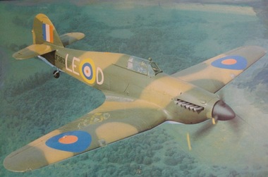
Picture Print, Hurricane, Unknown
The Hawker Hurricane is a British single-seat fighter aircraft of the 1930s–40s that was designed and predominantly built by Hawker Aircraft Ltd. for service with the Royal Air Force (RAF). It was overshadowed in the public consciousness by the Supermarine Spitfire's role during Battle of Britain in 1940, but the Hurricane actually inflicted 60 percent of the losses sustained by the Luftwaffe in the engagement, and it went on to fight in all the major theatres of the Second World War. Url Hurricane.html. The Hawker Hurricane Mk.IIc - LF363, first flew on the 1st January 1944 and is believed to be the last Hurricane to enter service in the RAF. It was in service with 63 squadron and 26 squadron. After hostilities, LF363 was spared the scrap yard and used on various station flights and also appeared in films 'Angels one five', 'Reach for the Sky' and 'The Battle of Britain'. Whilst flying to Jersey in September 1991, LF363 suffered engine problems and had to be diverted to RAF Wittering but on the final approach the aircraft suffered complete engine failure and had to make an emergency landing. The pilot was saved with relative minor injuries (a broken ankle and minor burns) but the aircraft suffered severe damage. Historic Flying Limited completely rebuilt LF363 and by 1998 it was flying again as part of the B.B.M.F. LF363 currently wears the colour scheme of a Mk.I Hurricane of 17 squadron, P3878 'YB-W' which was flown by Flying Office Harold Bird-Wilson at Debden and Tangmere. Harold 'Birdy' Bird-Wilson had previously been badly burned in a pre-war flying accident. Upon his recovery he joined 17 squadron and fought through the 'Battle of France' and the 'Battle of Britain' achieving 6 confirmed kills. On 24th September 1940, 'Birdy' was shot down by Adolf Galland, his 40th 'kill', and had to bale out. 'Birdy' survived the war and when he retired from the RAF he had reached the rank of Vice Marshall and had been awarded the CBE, DSO, DFC & Bar and the AFC & Bar. British single-seat fighter aircraft manufactured by Hawker Aircraft, Ltd., in the 1930s and ’40s. The Hurricane was numerically the most important British fighter during the critical early stages of World War II, sharing victory laurels with the Supermarine Spitfire in the Battle of Britain (1940–41) and the defense of Malta (1941–42). Hurricanes served in all theatres of war where British forces were engaged. https://www.britannica.com/technology/Hurricane-airplane Framed coloured picture print on plastic sheetOn the aircraft are the markings LF 363 -
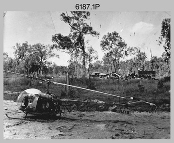 Bendigo Military Museum
Photograph - Bell 47G-2 helicopter used in Royal Australian Survey Corps Field Operations, c1965
This is a set of four photographs of Bell 47G-2 helicopters used in Royal Australian Survey Corps Field Operations. c1965. From 1957, helicopter transport of survey parties revolutionised transport in remote areas. The most common helicopter used by the Royal Australian Survey Corps at this time was the civilian Bell 47G-2 and the Sioux, the Australian Army’s’s equivalent. equivalent. From 1964 an Aerodist MRC2 airborne Electronic Distance Measuring (EDM) system was extensively used for topographic surveys over long distances by trilateration to replace traverse requiring survey station intervisibility. In 1965 the command field survey unit personnel attached to the Army Survey Regiment’s Topographic Squadron were used mainly in support roles such as station clearing, tower operations, station monumenting, Aerodist computations, forward base operations, geodetic observations on the north-south traverse and logistic support for Remote teams. .1P is a photo of a civilian Bell 47G-2 helicopter Registration / Serial VH-UTB owned by Helicopter Utilities from Mascot, NSW c1965. In the background of this photograph is three personnel and vehicles at a field survey camp. The left-hand vehicle is a Willys Jeep with trailer and on the right is probably a Truck, 2 1/2 ton, 6x6, General Service GMC. The Bell 47G-2: VH-UTB was destroyed, and its pilot killed in tragic circumstances during a civilian survey operation on Cape York Peninsula in June 1966. .2P is a photo of a a civilian Bell 47G-2 helicopter Registration / Serial VH-IHB taken in Wyndham, WA. As the letters ‘TAA’ appear on the fuselage, the helicopter was charted from Trans Australian Airways. .3P is a photo of a Bell 47G-2: VH-UTC with survey camp in background. .4P is a photo of a Bell 47G-2 equipped with floats and unidentified personnel loading stores, possibly in Darwin. Acknowledgement: Royal Australian Survey Corps – Aerodist Years 1964-1975 Version 2021.0 Authored by Peter Jensen.This is a set of four photographs of civilian Bell 47G-2 helicopters used in Royal Australian Survey Corps Field Operations. c1965. The photographs were printed on photographic paper and are part of the Army Survey Regiment’s Collection. The photographs were scanned at 300 dpi. .1) - Photo, black & white, c1965, Bell 47G-2 helicopter: VH-UTB with survey camp in background. .2) - Photo, black & white, c1965, Bell 47G-2 helicopter: VH-IHB with survey station in foreground. .3) - Photo, black & white, c1965, Bell 47G-2 helicopter: VH-UTC with survey camp in background. .4) - Photo, black & white, c1965, Bell 47G-2 helicopter: Unidentified personnel loading stores possibly in Darwin..2P – annotated on bottom of photo ‘Wyndham Area – Helicopter drops observing party’ The other photographs are not annotated.royal australian survey corps, rasvy, army survey regiment, army svy regt, fortuna, asr, surveying -
 Surrey Hills Historical Society Collection
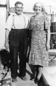
Photograph, Mr and Mrs Percy Pledger senior
Percy Henry (Harry) Pledger (1884-1954) and Eleanor Elizabeth George (1888-1963). They married in 1908 in St Peters, Paddington, London. Percy was a tailor in Barnet, Middlesex and the family migrated to Australia in 1923, arriving in Brisbane on 11 December 1923. They settled in Surrey Hills. Percy had a tailoring and later knitwear business at 418 Canterbury Road, almost opposite Alexandra Avenue (? also at another time in Hansen's Terrace in Canterbury Road). The family was musical. Their children were: Son Percy who joined the staff at Allan’s Music House and rose to become their chief accountant. He also taught and played the violin in a number of orchestras. (See individual entry for him - SH1207) Daughter Jessie married Arthur John Marston Bate (1906-1994) in 1941; he was born in Birmingham and his father was also a tailor. Arthur gained BA and MA from the University of New Zealand. He was also primarily a musician, but worked in theatre, broadcasting and teaching in New Zealand and at the State Theatre in Melbourne and the ABC. He was a pilot during WW2 (SERN 255363), rising to the rank of Flight Lieutenant and also a RAAF Chaplain. Jessie and Arthur lived in Hawthorn, Ashwood and Mount Waverley. They are buried in Box Hill Cemetery (CE-213-0029) along with daughter Christine Elizabeth. Stanley Bertram Pledger, along with Harold Sydserf, assisted Stan's brother Percy to establish the Surrey Hills Musical Club in the 1920s . It soon increased to 12 or 15 members, giving 4 concerts a year. They combined with the Surrey Hills Dramatic Society to produce operettas. In time the group expanded to a total of 30 players and became the Camberwell Symphony Orchestra. Stanley Bertram Pledger (1912-1996) is listed in electoral rolls at a number of addresses around Surrey Hills: 1927 - 36 Suffolk Road; 1940s - Essex Road; 1977 - Burwood. All entries consistently give his occupation as manufacturer and it is assumed that this was with the family business. He retired to Kiama, NSW.A black and white photograph of a couple standing in the rear garden. The lady is wearing a short sleeved, knee length dress and the man is wearing long trousers held up by braces and a short sleeved shirt.clothing and dress, tailor and knitwear, (mr) percy henry pledger, (mrs) eleanor elizabeth pledger, (mrs) nell pledger, (miss) eleanor elizabeth george -
 Surrey Hills Historical Society Collection
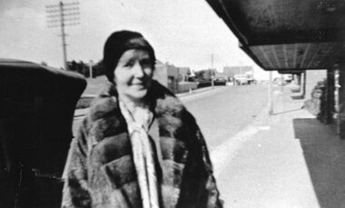
Photograph, Mrs Nell Pledger in Canterbury Road
Nell Pledger - Eleanor Elizabeth George (1888-1963) was the wife of Percy Henry (Harry) Pledger (1884-1954). They married in Paddington, London in 1908. Percy was a tailor in Barnet, Middlesex and the family migrated to Australia in 1923, arriving in Brisbane on 11 December 1923. They settled in Surrey Hills. Percy had a tailoring and later knitwear business at 418 Canterbury Road, almost opposite Alexandra Avenue (? also at another time in Hansen's Terrace in Canterbury Road). The family was musical. After leaving school son Percy joined the staff at Allan’s Music House and rose to become their chief accountant. He also taught and played the violin in a number of orchestras. (See individual entry for him - SH1207) Jessie married Arthur John Marston Bate (1906-1994) in 1941; he was born in Birmingham and his father was also a tailor. Arthur gained BA and MA from the University of New Zealand. He was also primarily a musician, but worked in theatre, broadcasting and teaching in New Zealand and at the State Theatre in Melbourne and the ABC. He was a pilot during WW2 (SERN 255363), rising to the rank of Flight Lieutenant and also a RAAF Chaplain. Jessie and Arthur lived in Hawthorn, Ashwood and Mount Waverley. They are buried in Box Hill Cemetery (CE-213-0029) along with daughter Christine Elizabeth. In the 1920s Stanley Bertram Pledger, along with Harold Sydserf, assisted Stan's brother Percy to establish the Surrey Hills Musical Club. It soon increased to 12 or 15 members, giving 4 concerts a year. They combined with the Surrey Hills Dramatic Society to produce operettas. In time the group expanded to a total of 30 players and became the Camberwell Symphony Orchestra. Stanley Bertram Pledger (1912-1996) is listed in electoral rolls at a number of addresses around Surrey Hills: 1927 - 36 Suffolk Road; 1940s - Essex Road; 1977 - Burwood. All entries consistently give his occupation as manufacturer and it is assumed that this was with the family business. He retired to Kiama, NSW.A black and white photograph of a lady dresses in a fur coat, and standing on the pavement with buildings in the background.alexandra avenue, canterbury road, union road, surrey hills, knitwear business, streetscape, (mrs) eleanor elizabeth pledger, (mrs) nell pledger, (mr) percy pledger, (miss) eleanor elizabeth george -
 Eltham District Historical Society Inc
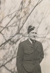
Photograph, Leading Aircraftsman, Lester Neil Ingram, RAAF, c.1943
Lester Neil Ingram was born at Kew, 8 November 1911, the son of John and Ada (Key) Ingram of Research. According to Electoral Roll records, in 1903, John Ingram was a farmer at Lancefield, his wife Ada, a milliner. By 1906, John Ingram was a baker at Research and from about 1912, an orchardist. The family moved to Anglesea River sometime between 1943 and 1949. A sheet metal worker by trade, Lester had run the bakery business for 14 years, his father retired, and was working as a baker at Anglesea when he enlisted in the R.A.A.F. on 5 December 1941 at Melbourne. Previously he had worked as a baker at Research (1937). He undertook training as Aircrew at No. 4 Initial Training School at Victor Harbour, South Australia, followed by No. 1 Wireless Air Gunners School at Ballarat, Victoria, and No. 3 Bombing and Gunnery School, West Sale, Victoria. On October 15, 1942 Lester qualified as an Air Gunner, promoted to Sergeant, and was posted to 1 Embarkation Depot at Ascot Vale, Victoria, and attached to R.A.F. UK. Lester embarked from Australia December 2, 1942 and arrived at 11 Personnel Despatch and Reception Depot on January 13, 1943. On March 9 he was transferred to 10 Operational Training Unit, Group No. 91, Bomber Command, R.A.F. Lester’s service file reveals that on the evening of 22 April 1943, Lester was a member of the aircrew of Whitley V bomber, N.1374. The airframe had run 1,127 hours. A full moon was just rising. The flight was non-operational, its purpose a dual conversion on type mission flown by a student pilot with almost two hours completed at night on similar flights. They had just changed aircraft as their previous aircraft had become unserviceable. The pilot had accepted the aircraft, which was technically unserviceable as the NCO in charge of flight had not completed the inspection paperwork correctly. The aircraft had undergone a major engine repair the day before. The aircraft took off at 2348 hours from R.A.F. Abington. It was reported that the aircraft take-off was quite normal and after climbing to 800 feet it passed out of view of the ground observers. A few seconds later the aircraft crashed, and it was reported that the sound of the engines seemed to become desynchronised. The crash occurred one and a half miles northwest of Longworth, Berkshire and the aircraft destroyed by fire. It carried a crew of five. Lester is commemorated on the Eltham Roll of Honour Board, which was commissioned by the Eltham War Memorial Trust to be hung in the Eltham Infant Welfare Centre, part of complex of buildings that form the Eltham War Memorial. The Honour Roll is presently (2023) hanging in the Eltham Library Community Gallery space. Lester was remembered with the following notices published in The Argus newspaper, Saturday 22 April 1944, p2: INGRAM. —In treasured memories you are with me still. Sgt. Lester Neil Ingram, killed, aircraft accident, England, April 22, 1943. (Mother and father.) INGRAM. —In proud and ever loving memory of Lester, 410236, Sgt. L. N. Ingram, R.A.A.F., air crash England, April 22, 1943. —Per ardua ad astra. (Ellen Peake and family.) [“Per ardua ad astra” is a Latin phrase meaning “through adversity to the stars” or “through struggle to the stars” which was the motto of the Royal Air Force and other Commonwealth air forces such as the Royal Australian Air Force.] And from his fiancé Ellen, in The Argus, Wednesday, 5 May 1943, p2: INGRAM. —On April 22 (result of aircraft accident near Lodgeworth Village, Berks, England), Sgt. Lester Neil Ingram, R.A.A.F., fiance of Ellen. -Treasured memories till we meet again. Lester is buried at Brookwood Military Cemetery, Surrey, United Kingdom, Grave 4. 1. 11. INGRAM, Flt. Sgt. LESTER NEIL, 410236. R.A.A.F. 22nd April 1943. Age 31. Son of John and Ada Ingram, of Anglesea, Victoria, Australia. He gave his life For freedom’s cause ◊ ◊ ◊ LEST WE FORGET “They shall grow not old, as we that are left grow old; Age shall not weary them, nor the years condemn. At the going down of the sun and in the morning We will remember them.”On reverse "Lester Ingram"lester neil ingram, baker, eltham, honour board, raaf, research (vic.), roll of honour, pam thoonen (nee ingram) collection