Showing 16995 items
matching plenty-river
-
 Lorne Historical Society
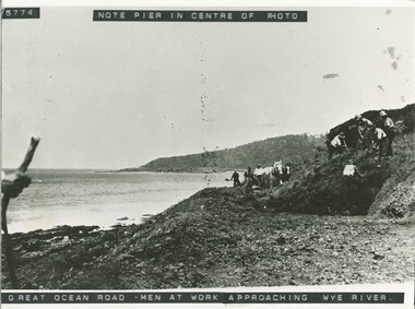
Photograph, Work on Great Ocean Road approaching Wye River
Photograph showing men at work on the G.O.R near Wye River. View of Pier centre photographg.o.r.; workmen; pier-at-wye-river; -
 Lakes Entrance Regional Historical Society (operating as Lakes Entrance History Centre & Museum)
Book, Rob Christie, Dargo Crooked River a Pictorial History, 1984
Short history of the Dargo Crooked River goldfield, which operated 1860 to 1900, illustrated with photographs.mines and mining -
 Port Fairy Historical Society Museum and Archives
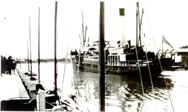
Photograph
Coastal steamer sank at Apollo Bay in 1932 Iron Steamship SS Casino Black & white photograph of ship in rivership, sea, river, ss casino, moyne -
 Greensborough Historical Society
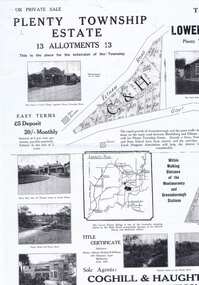
Plan - Advertising Leaflet, Coghill & Haughton, Plenty Township Estate and Bryn Teg Hill's Estate, 1925c
Copy of Real Estate Agent's advertising leaflet for two subdivisions, the Plenty Township Estate and Bryn Teg Hill's Estate in Lower Plenty, by order of Mrs M Thomas (d. 1925)Black and white photocopy of advertising leafletlower plenty, bryn teg, plenty river -
Lakes Entrance Regional Historical Society (operating as Lakes Entrance History Centre & Museum)
Photograph, 1940 c
Also a colour photograph of staircase from the wreck of the S S Riverina in the hotel at Cann River 04639.1 15 x 10 cm donated by Babs Harris 20 May 2001Black and white photograph of hotel and garage on opposite corner of Prines Highway, shed at back of hotel, petrol bowsers in front advertising Super Plume petrol and castol oil. Road narrow with large grassed area in centre, tall trees and vegetation close to buildings Cann River Victoriapublic works, topography -
 Greensborough Historical Society
Photograph, Unknown, Muddy track in Lower Plenty, 1920c
Muddy track in Lower PlentyBlack and white photograph, enlarged and laminated.plenty river -
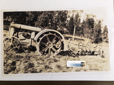 Whittlesea Historical Society Inc.
Photocopy of photograph, Ford tractor and plough Gibson's River Street Whittlesea, unknown
Photocopies of old photos from John McPhee of Conron Grange, Whittlesea. Conron Grange was established by Robert and Mary Ann Armstrong in 1855 as part of the Wills Estate, they were tenant farmers to Wills, Mary Ann named the first house Conron Grange meaning "Pretty place with full barns". Robert was killed falling from a horse in 1863 leaving Mary-Ann with children aged 7, 5, 3, 2, and a baby aged 8 weeks. Mary Ann married James Johnston in 1867. Conron Grange remained in the Johnston family until 1938 when John McPhee's parents bought it, it then remained in the McPhee name until John sold it in 2003. Photocopy of sepia photograph, A4 page, (5 of 20)Typed note attached to the rear, Ford tractor and plough Gibson's River Street Whittleseajohn mcphee, conron grange, whittlesea, mary ann armstrong, james johnston, wills estate, farming, ploughing, river street whittlesea, ford tractor, plough, gibson -
![Photograph (sub-item) - Black and White, The Wonga Park ‘swimming pool’ in the Yarra River, 1940’s – now in Jumping Creek Reserve (1985) [This may be the swimming pool in Jumping Creek Reserve or may be the swimming pool in Clifford Park in use in the 1948-9 Pan-Pacific Jamboree], Late 1940s](/media/collectors/5c7716e021ea6a1a60039fee/items/631b95b3d61f455ba20ef2cb/item-media/631b961fd61f455ba20ef417/item-fit-380x285.jpg) Wonga Park Community Cottage History Group
Wonga Park Community Cottage History GroupPhotograph (sub-item) - Black and White, The Wonga Park ‘swimming pool’ in the Yarra River, 1940’s – now in Jumping Creek Reserve (1985) [This may be the swimming pool in Jumping Creek Reserve or may be the swimming pool in Clifford Park in use in the 1948-9 Pan-Pacific Jamboree], Late 1940s
THE ROSE SERIES P. 922 SWIMMING POOL, RIVER YARRA, WONGA PARK, VIC. -
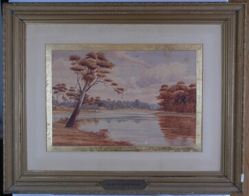 Glenelg Shire Council Cultural Collection
Painting, A.S. Murray, Scene on the River Murray, n.d
Art collection Previously located in History HouseThe painting depicts a large body of water surrounded by tree-covered riverbank. Depicted in shades of blue and grey, the water features patches of brown and blue which illustrate the reflections of riverbank trees. In the foreground to the left of the water is a large tree which extends up to cover the top left skyline of the work. Featured in the background is a dense patch of trees completed in shades of blue. To the right of the water is a dense patch of trees completed in shades of brown and black. These trees reach into a purple and blue cloud-filled sky. The work has a gilded ornate frame with cardboard and gold mount and exposed canvas.Front: A.S. Murray Plaque attached to frame: SCENE on the RIVER MURRAY Back: (no inscriptions) -
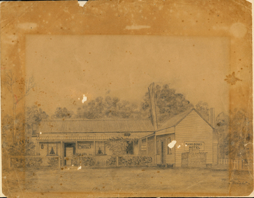 Orbost & District Historical Society
drawing, early 20th century before 1923
The original licence for the Sans Souci Hotel was granted to A. G. Ventry in 1909. The hotel burned down on 15.06.1923 and was rebuilt. It burned down again in 1936 and the licence surrendered 21.12.1936. with the owner compensated with 475 pounds and the occupier 50 pounds. (info Victoria Government Gazette Thursday December 24 1936) The hotel was at Upper Bemm River near Club Terrace in East Gippsland.This item is a contemporary pictorial record of a building which was once a popular destination for adventurous tourists in the early 1900's. There are few photographs of this hotel.A pencil (?) drawing of the old Sans Souci Hotel at Upper Bemm River, near Club Terrace. It is a one storey timber building. The drawing has been framed at one time causing differences in light damage.sans-souci-hotel bemm-river -
Lakes Entrance Regional Historical Society (operating as Lakes Entrance History Centre & Museum)
Postcard, H D Bulmer, 1908 c
Also a second black and white photograph of Swan Reach Tambo River 05378.1Sepia toned postcard showing the SS Burrabogie about to go through the open left bridge over the Tambo River at Swan Reach VictoriaSwan Reach Bridge Tambo Riverguesthouses, recreation -
Greensborough Historical Society
Document, A brief history of Lower Plenty, 1830o
A brief history of the Lower Plenty area.A starting place for further investigation of the area.2 pages.lower plenty, plenty river -
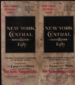 Federation University Historical Collection
Map, New York Central Hudson River Map and Timetable
Henry Sutton is a talented world-wide accepted inventor with inventions relating to the telephone, photography, wireless, cars, motorcycles, and bicycles as well as many more inventions. Henry was also one of four brothers that ran the Sutton's Music Store after the death of their Father Richard Sutton. Henry Sutton taught Applied Electricity at the Ballarat School of Mines in 1883 to 1886.New York Central Hudson River Map and Timetable with red and black writing used by Henry SuttonUnion Steam Ship Company of New Zealand Limited stamp on the front.henry sutton, union steam ship company of new zealand limited, new york central, hudson river, map -
 Lorne Historical Society
Photograph, Wye River Hotel
Melbourne Cup Day at the Wye River Hotel, "Fashions in the Field" Gwen and Charlie Hart outside the hotelwye river hotel, melboure cup, charlie hart, gwen hart -
Lakes Entrance Regional Historical Society (operating as Lakes Entrance History Centre & Museum)
Book, Davidson, Rachael, The Nicholson River Railway Bridge, 2004
Research, interpretation and management recommendations for the Nicholson River Railway Bridge, East Gippsland, Victoria, by a Forestec student.bridges, transport -
Lakes Entrance Regional Historical Society (operating as Lakes Entrance History Centre & Museum)
Book, Van der Heyden Becky, Calulu Mitchell River Bridge, 2004
Research interpretation and management recommendations for the Calulu Mitchell River Bridge, near Bairnsdale, Victoria by a Forestec Studentbridges, waterways, settlers -
Ballarat Heritage Services
Photograph - Video, Clare Gervasoni, Confluence of Canadian Creek and Yarrowee River near Anderson Street, Ballarat, 06/09/2022
The waterways of central Ballarat were channeled to prevent flooding and contain sludge during the mining era.Video of the confluence of Canadian Creek and Yarrowee River near Anderson Street, Ballarat flowing down a channel.canadian creel, yarrowee river, ballarat, anderson street, channel, bluestone -
 Brimbank City Council Art Collection
Photograph, Robert Pointon, From Essendon looking west over the Maribyrnong River towards Duke Street Quarries Essendon, early 1990s
Local SceneFrom Essendon looking west over the Maribyrnong River towards Duke Street Quarries Essendon - AR0017 -
 Eltham District Historical Society Inc
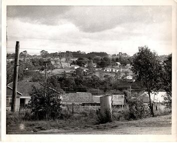
Photograph, Main Road, Lower Plenty at intersection of Old Eltham Road
View looking north across the main road towards the Lower Plenty shops showing the Lower Plenty Garage and store which was later developed into a Caltex service station, since demolished and replaced by a new Aldi supermarket.Black and white print Roll of 35mm colour negative film, 5 of 7 strips Kodak CP100 5094 and associated print Roll of 35mm black and white negative film, 3 strips Ilford FP4 and associated print Roll of 35mm colour negative film, 2 strips Kodak CP100 5094 and associated printaldi, caltex service station, lower plenty, lower plenty garage, lower plenty shops, main road, old eltham road, shops -
 Eltham District Historical Society Inc
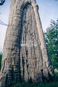
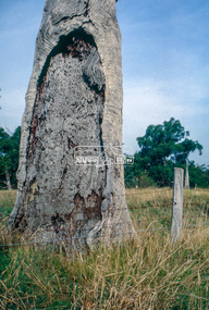
Slide - Photograph, Scar tree, Lower Plenty, c.Apr. 1993
Possibly near Bonds Road Lower Plenty35mm colour positive transparency (1 of 22) Mount - Kodak EktachromeProcess Date "Apr M"significant tree, lower plenty, scar tree -
 Eltham District Historical Society Inc
Slide - Photograph, Scar tree, Lower Plenty, c.Apr. 1993
Possibly near Bonds Road Lower Plenty35mm colour positive transparency (1 of 22) Mount - Kodak EktachromeProcess Date "Apr M"significant tree, lower plenty, scar tree -
 Greensborough Historical Society
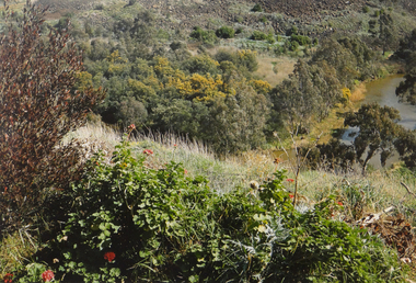
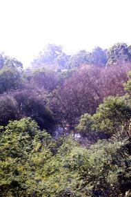
Slide - Photograph, John Ramsdale, Near Plenty Gorge: Slide 100, 1990s
Photograph shows bushland near Plenty GorgePart of the John Ramsdale collection of slides and audio visual material.Colour photograph scanned from slide.No maker's marks. No caption on slide.plenty gorge, plenty gorge metropolitan park -
 Greensborough Historical Society
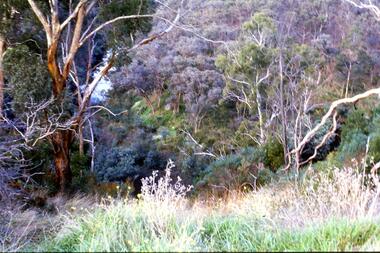
Slide - Photograph, John Ramsdale, Looking down on Plenty Gorge: Slide 38, 1990s
Photograph shows a view of the bushland at Plenty Gorge.Part of the John Ramsdale collection of slides and audio visual material.Colour photograph scanned from slide.No maker's marks. No caption on slide.plenty gorge metropolitan park, plenty gorge, bushland -
 Kew Historical Society Inc
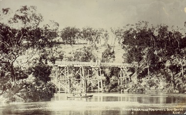
Postcard, J.W.K. & Co, River Yarra near Macauleys' Boathouse Kew, c.1910
The Zig-Zag Bridge which was constructed in the 1870s to link the Yarra Bend Asylum and Kew Asylum. Initially it transported bluestone from the west side of the Yarra to the east during the construction of the Kew Asylum.Real photo postcard of the Zig-Zag Bridge at Kew. In the middle ground there is a rowboat.Obverse: "River Yarra near Macauleys' Boathouse Kew". Reverse: "Gift from L Bennett"bridges -- river yarra, bridges - kew (vic.), zig-zag bridge -
 Greensborough Historical Society
Photograph - Digital Image, From Briar Hill towards Plenty Lane, 1960s
Briar Hill in the 1960s, looking towards Plenty LaneDigital copy of black and white photographbriar hill, plenty lane greensborough -
 Greensborough Historical Society
Book, Isabel Ellender, The Plenty Valley Corridor: the archaeological survey of Aboriginal sites / by Isabel Ellender 1991, 1991_
This archaeological survey of the Plenty Valley was conducted by Isabel Ellender in 1991 for the Board of Works (Melbourne Water), in particular the Plenty Gorge Metropolitan Park. The area studied is north of Greensborough to Whittlesea. A number of Aboriginal sites were identified and recommendations made for the future.67 p., illus., maps. Plastic spiral binding.plenty river, aboriginal heritage sites, plenty gorge metropolitan park -
 Eltham District Historical Society Inc
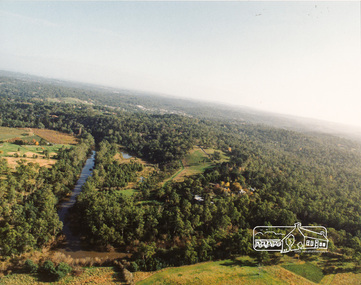
Photograph, Yarra River, Sweeneys flats, 1994c
Colour photogrpah of oblique aerial view looking east over Yarra River and Sweeneys flats c.1994sweeneys lane, yarra river, culla hill, thomas sweeney, aerial photographs -
 Wangaratta Art Gallery
Painting, Robert Horne, Overlooking the Howqua River, 1975
Rural City of Wangaratta Collection, Wangaratta Art Prize 1976.An aerial landscape depicting the Howqua River painted in synthetic polymer in shades of green, yellow, blue, brown, and white.Obverse: R HORNE 75/ (bottom right corner)wangaratta art gallery, robert horne, landscape, painting, howqua river -
 Peterborough History Group
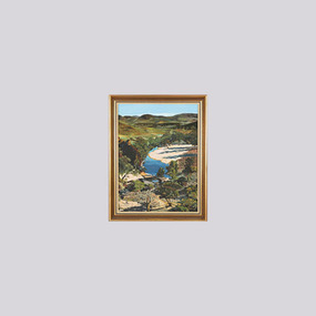
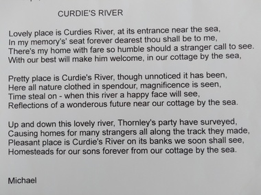
Document, James Meek et al, Curdies River, a poem
James Meek was one of the original settlers in the area. This poem is attributed to him.Poem showing James Meek's attachment to this area and in particular for the Curdies River estuary. Print out of an email from Michael Moore to Maree O'Connor with a poem called Curdies River by James Meekpeterborough, curdies river, james meek, curdies river estuary -
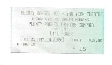 Greensborough Historical Society
Ephemera - Ticket, Plenty Ranges theatre ticket, 1999c
Ticket issued to the Plenty Ranges Theatre Company production of "Li'l Abner", Friday 21 May, although the year is not given it is possibly 2005. The Plenty Ranges Theatre Company inc was active from 15 June 2000. Ticket issued to R. Hooper.Pale green paper tickethooper family, plenty ranges theatre company