Showing 24981 items matching " north"
-
 Bendigo Military Museum
Administrative record - 1 Fd Svy Sqn Project Report - Operation Carto Mercury 1986, 28 Jan 1986
Operation Carto Mercury was a field completion Operation mounted by 1 Fd Svy Sqn 11 Aug 1985 to field complete 4 x 1:25000 compiled map sheet in the Cabarlah area to the North of Tawoomba. Included maps: 9243 - 23 Kingsthorpe, 9243 -24 Goombungee, 9243 - 21 Gomaren Creek, 9243 - 22 High FieldsA4 Typed document and diagrams, 14 pages. Report produced by 1 Fd Svy Sqn 1986royal australian survey corps, rasvy, fortuna, army survey regiment, army svy regt, asr, 1 fd svy sqn -
 Greensborough Historical Society
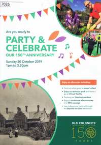
Pamphlet, Leith Park Celebration Day 2019 program, 20/10/2019
A celebration for the 150th anniversary of the establishment of the first Old Colonists Association of Victoria retirement village at Rushall Park North Fitzroy was held on 20 October 2019 at Leith Park St Helena. Leith Park was the Association's second village, built in the 1960s on land donated by Arthur C. Leith, Life Governor, Councillor and President of the Association 1949-1972.4 p. colour pamphlet printed on light cardboardleith park retirement village, old colonists association -
 Greensborough Historical Society
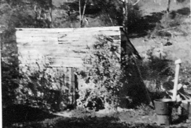
Photograph - Digital image, Outhouse, Willis Vale, 1920c
This photograph shows one of the out buildings at 'Willis Vale', a property owned and farmed by the Partington family from the 1870s. The derelict Willis Vale house was destroyed in 1964 when a fire originating from North Plenty Gorge - Kurrak Road - was lit by two teenage boys and made its way several kilometres down to Partington's Flat Greensborough.The hoe of a pioneer Greensborough family.Digital copy of black and white photograph.willis vale, partington family -
 Eltham District Historical Society Inc
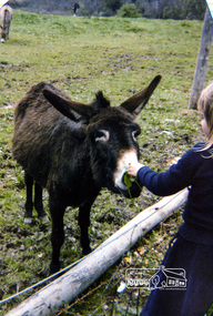
Photograph, Rachel Thomas feeding the donkey, Eltham Christian School, 1981, 1981
Rachel Thomas feeding the donkey, Eltham Christian School, 1981 when the school operated out of the North Soccer clubrooms. From series of photographs from a magnetic photo album relating to the staff, students and activities of the Eltham Christian School which operated as part of the Eltham Christian Church at Nyora Road, Eltham. See also entries for each photograph.Colour Photographeltham christian school, rachel thomas, donkey -
 Eltham District Historical Society Inc
Newsletter, Newsletter, No. 198 May 2011
Contents: • Next meeting, guest speaker; Ross McDonald and Bruce Draper: The McDonalds and the Drapers; two significant Nillumbik families • May Meeting • Eltham Lower Park Walk • Eltham Railway Line • Eltham North Bridge • Room Names at Our Local History Centre • Nillumbik Heritage Strategy • Subscriptions • Office Bearers 2011-2012 • And Also The Shire of Eltham Historical Society was formed in October 1967. The first newsletter of the Society was issued May 1978 and has been published continuously ever since on a bi-monthly basis. With the cessation of the Shire of Eltham in late 1994, the Society's name was revised to Eltham District Historical Society and this name first appeared with issue No. 103, July 1995. The collection of the Society's newsletters provides a valuable resource on the history of the Society's activities, office bearers and committee members, guest speakers and subjects of historical interest pertinent to the former Shire of Eltham and the Eltham District.A4 photocopied newsletter distributed to membersnewsletter, eltham district historical society, shire of eltham historical society -
 Kiewa Valley Historical Society
Book - Bogong High Plains x2, Early History and Discovery of the Bogong High Plains, 1968
The State Electricity Commission of Victoria constructed the Kiewa Hydro Electric Scheme in the north east of Victoria. Mr R.M. Duncan prepared the notes. He was a member of the S.E.C. Kiewa Branch from 1949 - 1966. This book was commissioned by the State Electricity Commission of Victoria. It consists of the early history of the Bogong High Plains and the origin of names of places and creeks in the area.This book was researched in 1968 by Mr R.M. Duncan who worked for the S.E.C. on the Kiewa Hydro Electric Scheme from 1949 to 1966. His sources were the Melbourne Public Library, the Victorian Historical Society, the North Eastern Victorian Historical Society and the Dept. of Crown Lands & Survey, Melbourne. The book is an accurate history of the Bogong High Plains given the available records at the time. Yellow cardboard covered book with black sketches and green print. 9 one-sided pages held together by 3 staples and taped over the staples. One - has sheets enclosed "The Three Floras of Bogong" and "General Geology of the Kiewa Area". 6 copies including 1 that is a photocopyDDTS hand written on front cover "Early History and Discovery / of the / Bogong High Plains" on cover top centre. "Settlement / of the / Kiewa-Valley" on cover towards the top slightly to the right. "Published by the / State Electricity Commission / of Victoria / July, 1968" on cover bottom left. "TR-K 596-4" on cover bottom left.bogong high plains. state electricity commission of victoria. kiewa. aborigines. kiewa valley. mullindollingong pastoral run. flora. geology -
 Eltham District Historical Society Inc
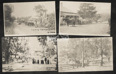
Photograph, Tom Prior, Group of scenes from the Eltham District, c.1905
Photo shows four images from the Shire of Eltham Pioneers Photograph Collection: SEPP_0501: West's Research Hotel, Main Road, Research, c.1907 SEPP_0612: Eltham, Main Road. Looking north from corner of Dudley Street, c.1904 SEPP_0616: Forming the footpath, Eltham, c.1906 SEPP_1000: Main Road, Hurstbridge, c.1905 Black and white/sepia photograph of four individual photographsbakery, eltham, eltham village reserve, footpath, gahan house, general store, haley's paddock, hurstbridge, luther haley, luther haley general store, main road, old mac (horse), picnic, pioneers and painters, punch (horse), railway store, research (vic.), research hotel, reynolds prior collection, richard reynolds, road construction, sepp, shire of eltham pioneers photograph collection, summer drinks, tilley lamp, york street -
 Old Colonists' Association of Ballarat Inc.
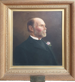
Painting - Image, T. Stanton Bowman, R.U. Nicholls, c1907
Robert Uriah Nicholls was born in Devonshire, England, and arrived in Victoria in 1853 on the Banker's Daughter, and Ballarat in 1854. He ran R.U. Nicholls & Co., nurserymen in Doveton Street North, Ballarat. He was a member of the Ballarat Horticultural Society for 51 years, and was President of the Old Colonists' Association in 1907. Robert Nicholls died in 1910, and is buried at the Ballaarat New Cemetery.Portrait of R.U. Nicholls, President of the Old Colonists' Association in 1907old colonists' association ballarat, stanton bowman, t. stanton bowman, r.u. nicholls, robert uriah nicholls -
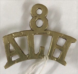 8th/13th Victorian Mounted Rifles Regimental Collection
Badge - 8ALH title
The 8th Light Horse was raised from companies of the colonial Victorian Mounted Rifles located in North-east Victoria following federation. In 1912 a major reorganisation of the Australian military forces resulted in the regiment being renumbered 16th Light Horse. Following World War One the regiment reverted to 8th Light Horse with the territorial title Indi Light Horse.Metal shoulder title of 8th Australian Light Horse worn on the epaulet during the period 1900-1912.light horse, victoria, federation -
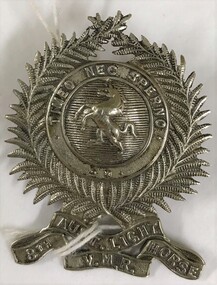 8th/13th Victorian Mounted Rifles Regimental Collection
Badge - 8ALH hat badge
The 8th Light Horse was raised from companies of the colonial Victorian Mounted Rifles located in North-east Victoria following federation. In 1912 a major reorganisation of the Australian military forces resulted in the regiment being renumbered 16th Light Horse. Following World War One the regiment reverted to 8th Light Horse with the territorial title Indi Light Horse.Metal hat badge of 8th Australian Light Horse (VMR) worn during the period 1900-1912., and with motto 'Timeo Nec Sperno'light horse, victoria, federation, vmr, 8th -
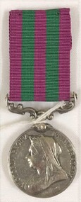 8th/13th Victorian Mounted Rifles Regimental Collection
Medal - India Medal 1895
The India Medal was a campaign medal approved in 1896 for issue to officers and men of the British and Indian armies. The India Medal was awarded for various minor military campaigns in India, chiefly for service on the North-West Frontier during 1895 to 1902. This medal replaced the India General Service Medal (1854). Each campaign was represented by a clasp on the ribbon; seven were sanctioned.White metal medal with maroon and black striped ribbon.india, 1895, north west frontier, british army -
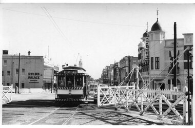 Ballarat Tramway Museum
Photograph - Black and White - Lydiard St level crossing, A T Miles, 30/1/1968
Black and White - set of two photographs taken at the Lydiard St level crossing with the gates. Taken by A T Miles 30/1/1968. 1 - tram 26 (Gregory St), north bound passing as the gates were opened. 2 - tram 14 (City), passing south bound through the crossing. Tram has a Cinzano roof advert.Yields information about the Lydiard St level crossing.Set of two Photographs - black and white print with notes on rear. A T Miles stamp and location and date notes.tramways, trams, lydiard st north, level crossing, gregory st., tram 26, tram 14 -
 Ballarat Tramway Museum
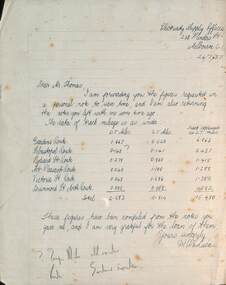
Letter - Track miles - Ballarat, State Electricity Commission of Victoria (SECV), 7/1937
Letter from H W C Lucas of SEC Melbourne to Mr Thomas setting out the track mileage for Ballarat's 6 tram routes - Double track, single track or route miles. Totals 15.480miles. Compiled from Mr Thomas's notes. Letter dated 26/7/1937 which is before the opening of the extension to Lydiard St North.Yields information about Ballarat track and route mileages.Letter hand written on ruled quarto paper.tramways, tramcars, mileage, secv -
 Ballarat Tramway Museum
Postcard - Ballarat tram 40 Wendouree Parade, Colin Withington, c1985
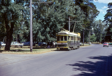
Postcard with a photo by Colin Withington, shows BTPS operated tram No. 40 in Wendouree Parade to the north of Gardens Loop with the destination of St Aidans Drive. Tram has an Eureka tiles and SEC Cooking advertisement. On the rear of the card, has details of the tram, Museum operations and mailing address. Has card printer details - b/p M357 on rear.Yields information about BTPS Operations mid 1980's and Wendouree Parade during winter.Postcard - serated edges with divided back featuring BTPS Tram No. 40 in Wendouree Parade.ballarat, trams, tramcars, tram 40, btps, wendouree parade -
 Tarnagulla History Archive
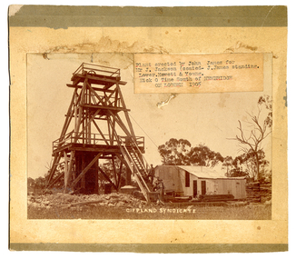
South Gippsland Syndicate mine, Nick o' Time Lead, 1905, 1905
John James is standing on the staircase. He erected the poppet head and buildings on behalf of the syndicate. He was an experienced mine manager and highly regarded local engineer. The mine was located close to and on the western side of the Newbridge-Eddington Road, approximately one kilometer north of the Poseidon Road intersection. The remains of a once-prominent mullock head can be seen on the site. Paper label stuck onto image reads 'Plant erected by John James for Mr J. Jackson (seated - J. James, standing). Lower Hewett & Young. Nick O Time South of Newbridge ON LODDON 1905'. -
 Offshore & Specialist Ships Australia
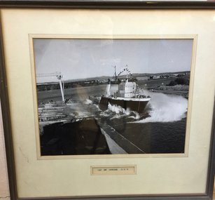
Photograph - Lady Ann launching
Launching of anchor handling tug supply vessel 'Lady Ann' at Carrington Slipways, Newcastle, New South Wales on 15th August 1976. Naming performed by Ann McBain, wife of the then General Manager Captain Duncan McBain of Australian Offshore Services, a division of P&O Australia Ltd. The 'Lady Ann' sank off the North West shelf of Australia. Black and white photographLabel -
 Tarnagulla History Archive
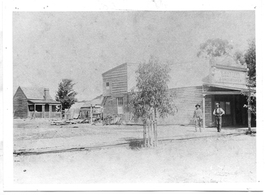
Photograph of P. Master's premises, Tarnagulla, P. Master's premises, Tarnagulla, Late 19th Century
Murray Comrie Collection. Information collated by Murray Comrie: Premises of P. Masters, cabinet-maker and funeral undertaker in Commercial Road, next to Cheetham's on the north side. Phillip Masters' Store was located in Commercial Road, opposite and south of the Victoria Theatre. This photograph is a reasonable copy created from an older original. Copy probably made by Murray Comrie in the 1970s. Monochrome photograph depicting a building with shopfront, two men standing in front. View past building to a small cottage in background.tarnagulla, commerce, shops, stores, masters, p. masters, funerals, commercial road, main street -
 Ballarat Tramway Museum
Photograph - Digital Image - first public day - tram 38 Wendouree Parade, Paul Nicholson, 26-12-1974
Photo of SECV/BTPS tram No. 38 in Wendouree Parade near Windmill Drive North on the first day of public operations by the Ballarat Tramway Preservation Society - Boxing Day 1974. Photo by Paul Nicholson. Tram is showing the destination of Gardens via Sturt St West, before the blinds were extended for Cartlon St and St Aidan Drive.Yields information about the first day of public tram operations on 26-12-1974 by the BTPSDigital image of a colour slide.tramcars, tramways, btps, wendouree parade, tram 38 -
 Williamstown Botanic Gardens- Hobsons Bay City Council
Postcard - Postcard – Williamstown Botanic Gardens, The Crown Studios, Sydney, c1900-1910
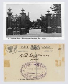
The cast iron gates (manufactured in Glasgow) introduced at the North West entrance in 1907. The gates were purchased from ‘Fairlie” corner of Acland and Anderson Streets, South Yarra at the cost of 72 pounds and cost 60 pounds to install. They had originally cost the owners of ‘Fairlie’ 1200 pounds. Lee Heap Furniture Warehouse of Williamstown used the postcards to advertise. The postcards are evidence of the interest the gardens held as a subject for postcard publishers. The text and images provide a snapshot into fashions, social interests and concerns of the time. The professionally produced images provide a pictorial history of Gardens including changing planting styles, various structures and features of the Gardens eg the aviary, cannons, the fountain, the second Curator’s Lodge and gates. The images offer an opportunity to compare garden vistas with the present day. The image in this postcard shows the gates intact and as installed in 1907. The current layout of this area still reflects the change of design, which followed the 1907 removal of the first gardener's residence and the subsequent re-organisation of this quarter of the gardens. This postcard is evidence of the placement of one of the cannons relocated from Fort Gellibrand in 1906. They were removed from the Gardens in the 1960s. These same cannons remain a feature on the Williamstown waterfront in 2013. Black and white image of main entrance gates which are open. Through the gates can be seen a man in waistcoat standing in front of a cannon. The gates are cast iron, double carriage gates with single pedestrian gates on either side and supported by four cast iron posts with ornamental finials. Front: ‘The Entrance Gates, Williamstown Gardens. Vic.’ ‘0457/2’ ‘THE CROWN STUDIOS, SYDNEY’. Reverse: Centre top ‘POST CARD’ with a logo in the middle of the words. Left top corner a drawing of an artist’s board and brushes with a camera in the centre. Left side ‘MESSAGE ONLY.’ Right side ‘ADDRESS ONLY.’ Top right corner inside a dotted rectangle ‘STAMP HERE’. Bottom on card ‘BY THE CROWN STUDIOS, SYNDEY.’ Under the vertical line down the middle line ‘Neither the Address not the Message must cross this line’. In ink ‘With Compliments / from’. An oval stamp with scalloped rim ‘LEE HEAP FURNITURE MANUFACTURER’ inside inner oval ‘FURNITURE WAREHOUSE, / WILLIAMSTOWN’.postcard, gardens, post-card, williamstown-botanic-gardens, hobsons-bay-city-council, entrance gates, entrance-gates, cast iron, finials, cannon, crown studios, lee heap furniture warehouse -
 Melbourne Tram Museum
Photograph - Black and White V class 215 at Preston Workshops 1925
Tram originally built for The North Melbourne Electric Tramways and Lighting Co. (NMETL) in 1906 as a straight sill open cross bench tram. Photograph is of the tram body on an un-motored truck or wheel set and has been posed for an official MMTB photograph in 1925, soon after the workshops were completed. It shows the destination of "M River" for Maribyrnong River.Shows the only type of fully open cross bench tram operated by the MMTB. This style was popular as a summer tram in North America. Originally built by Brill (USA) in 1906 and assembled by Duncan and Fraser for the NMETL as Tram No. 14. Taken over by the MMTB in 1922 and given the number 215.Black and White photograph of V class 215 at Preston Workshops 1925.In ink on rear "V class"trams, tramways, v class, preston workshops, tram 215, nmetl, brill, mmtb, uniforms -
 Melbourne Tram Museum
Document, VicRoads, "St Kilda Road track maintenance and road closure", April 2024
Set of documents for the reconstruction of tram track in St Kilda Road between Inkerman and Carlisle Streets St Kilda April and May 2024. During the works, the route 3 tram, running as a 3a, used the North West curves of the Grand Union at Balaclava junction at designated times. These curves are seldom used. Published by both VicRoads and Yarra Trams.Yields information about the April-May 2024 trackworks in St Kilda Road.Set of two A4 landscape documents - 9 pages.trackwork, tramways, st kilda road, balaclava junction, route 3 -
 Melbourne Tram Museum
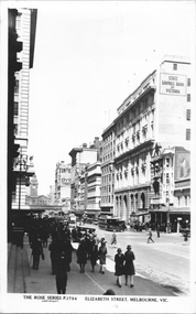
Postcard, Rose Stereograph Co, "Elizabeth Street Melbourne", c1930
Rose Series postcard No. P 1704 titled "Elizabeth Street Melbourne", looking south from the Post Office steps, just north of Bourke St. Has three cable trams in the view, along with the State Savings Bank Building, Flinders Street Railway Station building, adverts for Tintex Dye, Carlton draught beer and R W Rab.Yields information about Elizabeth St, c1930Postcard - printed real photograph with Rose Stereograph Co. name on the rear.On rear in pencil "KM-M-079" and a Ken Magor stamp.trams, tramways, flinders st station, cable trams, elizabeth st -
 Warrnambool and District Historical Society Inc.
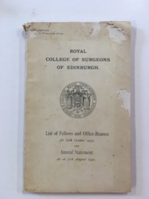
Booklet, Royal College of Surgeons of Edinburgh, 1932
This report documents office bearers from the 1535 and a chronological list of fellows from 1873 up to 1932. William Roy Angus a doctor who practiced in Warrnambool and to whom this booklet belonged, is listed among the fellows of 1928. It lists his contact details as C/- Mr W J Angus 37 Kermode Street North Adelaide South Australia.A link to a member of the Warrnambool community.Cream cover with black text and circular emblem in centre of cover. The back cover has small text in the centre.140 pages. December 1932. J W Dowden.warrnambool, royal college of surgeons edinburgh 1932, william roy angus -
Surrey Hills Historical Society Collection
Work on paper - Vertical file, Anne's Pantry
Anne's pantry was one of the early shops in the 1920s-1930s shops to be built to the north of the railway line. It was started by Miss Cook and Miss Porteous and has had a continuous history since, although it has changed location within the strip several times. No-one seems to know the origin of the name 'Anne'. Nick and Judy Hilverda took over in 1971. Vertical file of information related to the Union Road business known as Anne's Pantry: 1. Anne’s pantry cake shop notes written by Miss Porteous Nov. 1979 (2 handwritten pages). 2. Typed copy of No. 1 (2 pages). 3. ‘Twenty years over a hot stove!’ SHNN, Oct.-Nov. 1991 (1 page). 4. ‘Anne’s pantry – it’s history’, E. Porteous, Nov. 1979 (1 page).anne's pantry, nick hilverda, judy hilverda, miss cook, miss e porteous -
 Orbost & District Historical Society
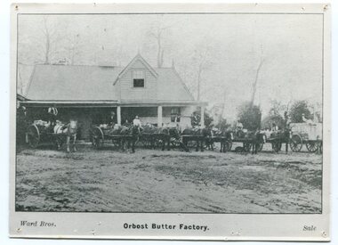
black and white photographs, Ward Bros, late 19th century - early 20th century
The photographs show the Butter Factory at Orbost in 1892 and 1906. The postcard is addressed to Miss N. Cameron C/- Mrs H. Nixon of Picnic Point Bairnsdale. The Orbost Butter and Produce Co. Ltd was registered on June 1st 1893 and was an important source of income to the Orbost district. The first shipment in about 1893 to England went rank and was only good for axle grease on wagons and carts.The milk was brought to the factory by horse and dray.Most people would take the whey home for their pigs,which were abundant on the farms in the Orbost district. Mr John Gilbert is the man second from the left in 1250.1.Postcards form a vital part of social and historical records for researchers. These cards are photographs of the Orbost Butter Factory. The Orbost Butter and Produce Co. Ltd was registered on June 1st 1893 and was an important source of income to the Orbost district. Two photographs / postcards of the Orbost Butter Factory. 1250.1 is a a photograph of several horse-drawn wagons outside a large wooden building.There are several men on top of the wagons, seated and standing. 1250.2 is a postcard with a photograph of the butter factory taken from the north side showing the two storeys with a person standing at a door on each level. There are horse drawn carts behind a wooden fence and several men standing on the front verandah with one man at a top window. On the back of this postcard is a hand-written letter.1250.1 - on front - Orbost Butter Factory Ward Bros Sale 1250.2 - on front - Butter Factory Orbost on back - " 27/11/06 Dear Girls Yours to hand you should have had a letter from me yesterday. Glad you wrote to Miss Alexander. Hope ypou have a good time out there. ??? meeting a success, Mother"dairy-orbost orbost-butter-factory -
 Bendigo Military Museum
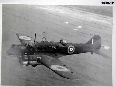
Photograph - PHOTOGRAPHS, RAAF, c.1939-45
Items belonged to Maxwell Lennox Matheson No 418447 RAAF. Refer Cat No 1959 for his service records.Envelope containing 5 photos: .1) 1P Auro Anson T.1 - Fuselage number W2083 .2) 2P Laverton RAAF Base B&W c.1938 Bunch of Airmen marching past Hawker demons .3) 3P North American b&w RAAF P51 Mustang Number A68-585 .4) 4P Airspeed 'Oxford' b&w Fuselage Number V3354 .5) 5P Blue print 'Wirraway' Fighter/Bomber.1) 3 Lines description on rear. RAF Aircraft issued to RAF .2) Laverton RAAF Base C1938 & 2 lines about Hawker Demons & Auro Ansons .3) 5 lines about history of P51 & No 84 Sqn 1945 .4) Rear inscription 4 historical lines about AIirspeed Oxfords .5) Front inscription on blue print: Wirraway' as a General Purpose Trainer Aircraft No A70-98 Wirraway' as a Dive Bomber Aircraft No A20-754photography -photographs, raaf -
 Glenelg Shire Council Cultural Collection
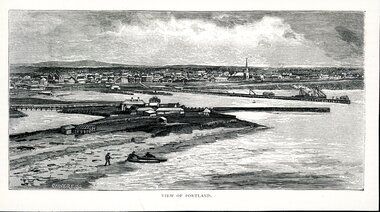
Artwork, other - Illustration Portland Barton's Beach, n.d
Illustration. Taken and cut from a book. Black and White rectangle image on off white paper. Portland from Barton's Beach, looking north west. Panoramic view in background of Portland's town with original buildings. All Saints Catholic Church with spire recognisable. Pier in the Middle right with various structures and a docked ship with sails. Bottom left 3 people launching two canoes at the beach. Wattle Creek or Salt Creek with bridge structure on the middle left. Front: 'VIEW OF PORTLAND' - printed, bottom frame. Signature 2cm in from the left corner of the frame 'CALVERT. SS'portland, bartons beach, portland bay -
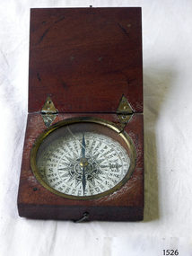 Flagstaff Hill Maritime Museum and Village
Instrument - Compass, c. 1839
This magnetic compass is a good size to fit easily into a person's pocket or personal luggage and is protected from knocks by its wooden case. It could have been used for reference when travelling on land or sea. There is no visible manufacturer's mark, which may mean that it was not of high monetary value. Leith is a district of Edinburgh in the country of Scotland, the U.K. It was once the Port of Edinburgh and many migrant ships departed from here bound for the Australian colony. It had a busy shipbuilding industry, with wet and dry docks. It appears from the inscription on the case "Chas Gray, LEITH, 1839" that this pocket compass once belonged to Charles M. Gray (Chas is a common abbreviation for the name Charles). The inscription coincides with the name, place and date that the Western Victorian pioneer Charles M. Gray left Scotland and arrived in Australia. Charles Gray was born in Anstruther, Scotland, in 1818. His family was connected with the Royal Marines, which may have created his nautical instruments such as this pocket compass. Charles Gray arrived in Hobson's Bay on 15 June 1839 on the ship “Midlothian”. That same ship had departed from Leith, Scotland on February 15th 1839. Did Charles Gray acquire the pocket compass in Leith, perhaps as a gift or a souvenir of his motherland? Charles Gray was an early squatter and went on to become a very successful settler as a sheep pastoralist in the Western District of what is now Victoria (originally the colony of New South Wales). He and his wife had a large property called “Nareeb Nareeb”, Green Hill Creek District (now Glenthompson), Victoria, from 1840-1886. He was also a local Councillor and Justice of the Peace, and had an interest in the local indigenous people; he named his property after their tribe. Charles returned to England in 1890 and died there in 1905. Charles Gray had written an account in 1890 of his life at Nareeb Nareeb, called Western Victoria in the Forties: "REMINISCENCES OF A PIONEER The Western District in the 1840's By Charles Gray" , a valuable historical reference to colonial Victoria. His book was published by the Hamilton Spectator in 1932. Charles Gray's photograph is one of 713 historical photographs of early Victorian settlers, created as a montage by Thomas Foster Chuck in 1872. The State Library of Victoria holds the framed montage titled “The Explorers and Early Colonists of Victoria”. To qualify for inclusion on this montage the Settlers must have arrived in Victoria before 1843. Charles Gray's photograph is number 349! The pocket compass is associated with Charles Gray, one of the early squatters and settlers in Western Victoria, possibly given to him as a parting gift on his emigration to Van Diemans land in 1839. The item is very significant as it's connection with one of Victoria's early pioneers is well provenanced by the inscriptions on the wooden case. Pocket compass, brass, set into a square wooden case with hinged lid and small hook catch. Compass is marked with 360 degrees and compass points and has two pointers; one to show magnetic north and one to set the direction of travel. Hinges are triangular and inset into the wood. The lid has an attached brass plaque with the inscription "Chas Gray, Leith, 1839" (It likely belonged to Charles Gray, Leith, UK, who migrated to Port Philip Australia in 1839 and became a successful pastoralist.) “Chas Gray / LEITH / 1839” engraved on brass plaque on lid.flagstaff hill, warrnambool, shipwrecked coast, flagstaff hill maritime museum, maritime museum, shipwreck coast, flagstaff hill maritime village, great ocean road, magnetic compass, pocket compass, charles m. gray, chas gray, migrrant from leith 1839, charles gray anstruther, scottland, ship midlothian 1839, squatter western victoria, settler western victoria, hobson's bay port phillip australia, charles gray nareeb nareeb - green hill creek district, western victoria in the forties: reminiscences of a pioneer by charles m. gray 1890, leith edinburgh u.k., western victoria in the forties: reminiscences of a pioneer - montage by thomas foster chuck 1872, charles gray, reminiscences of a pioneer, the western district in the 1840's, compass, scientific instrument, nautical instrument, direction, directional compass, navigation -
 Federation University Historical Collection
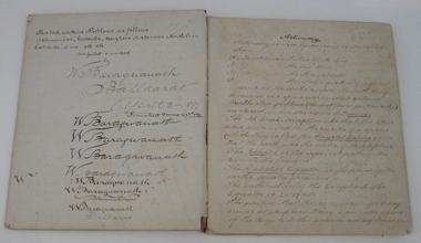
Book - Exercise Book, Astronomy Notes by William Baragwanath, 1897
William Baragwanath studied at the Ballarat School of Mines, obtained a Geology certificate in 1911. He was born on 01 August 1878 at Ballarat. He joined the Victorian Department of Mines in 1897 and was Chief Mining Surveyor from 1924 to 1943. Baragwanath died at Prahran on 20 September 1966. See Book 2 - Catalogue Number 4530Marbled card covered exercise book with brown tape spine containing handwritten notes by William Baragwanath on Astronomy and astronomical, geodetic, geights and distances, North Line Latitue, Lime, etc., problems . Headings include: Astronomy refraction Correction for Semi diameter Determination of True Meridian Elongation Observation Latitude Determining the TIme Convergence of Meridian Barometric Measurement of Heights Formulae Latitude Observation On the Division of Land Calculations for Observations by a Single Altitude Computations Triginometrical Rations of Two Arcsballarat school of mines, astronomy, william baragwanath -
 Federation University Historical Collection
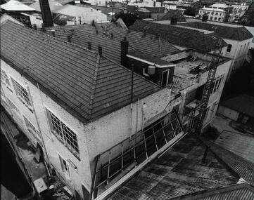
Photograph - Photographs - black and white, Ballarat School of Mines: Lydiard Street Campus Buildings, early 1900s, c1978
These photographs were taken just before structural modifications and connecting overhead walkways were commenced in 1978.1: Art School opened in 1915 on the site of the original SMB building.It was converted from the abandoned court house. Also Administration building including the teaching and other spaces. .2: "Old Chemistry building" showing the south side and west end. .3: Art school on the left, Ballarat Brewery boiler chimney stack in centre background, Administration building on the right. .4: Entrance on the north side of Art School building .5: South side entrance of Administration building.ballarat school of mines, buildings, a building, administration building, lydiard street south, smb campus