Showing 24981 items matching " north"
-
 Ballarat Tramway Museum
Slide - 35mm slide/s, Ben Parle, 8/04/1958 12:00:00 AM
Kodachrome Transparency - 35mm slide - cardboard mount, with one side with red border and words "Kodachrome Transparency / Processed by Kodak" top and bottom. Photo taken by Ben Parle 8/4/1958. Has slide No. "4" stamped in black in top corner. Photo of Ballarat No. 31 outbound in Drummond St. North, passing through the Mill St. loop Tram has the destination of Gardens via Drummond Nth. For high resolution scan see btm2863.tif "Drummond St. N Ballarat" / "8-4-58"tramways, trams, drummond st nth, mill st loop, tram 31 -
 Ballarat Tramway Museum
Photograph - Digital image, c1890's
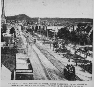
Yields information about the appearance of Sturt St Ballarat c1971.Digital image copy of a black and white print of Sturt St from the Fire Brigade tower looking east. Has title "Sturt St from fire Brigade Tower, Mount Warrenheip (in the distance), St. Patricks RC Church (on the right), and Spire of St Andrew's (on the left). Has a well loaded horse tram outbound on the north side of Sturt St. C1890's, trees in the median strip are still young. On rear is "BTPS Sales department" in green ink. trams, tramways, sturt st, horse trams -
 Ballarat Tramway Museum
Photograph - Black & White Photograph/s, Doug Colquhoun, 15/05/1971 12:00:00 AM
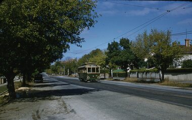
Yields information about Ballarat's trams in the early 1970's and the street scape from Lydiard St to Bridge St.Black and white print of Ballarat 32, in Wendouree Parade, north side of Lake Wendouree, near the depot. Two copies. Photo by Doug Colquhoun, 15/5/1971. Trams has the destination of Gardens via Drummond Nth. Photo print courtesy of Port Dock Railway Museum, now the National Railway Museum. See worksheet 4311 for letter and details of prints sent to Bill Scott, 19/10/2001. Any photo credit to mention NRM Collection.On rear of copy 1 "SEC Ballarat / 32 /Near Depot / 15/5/71 4162 / D.A. Colquhoun" . Copy 2 "DAC" in ink, bottom right hand corner.trams, tramways, wendouree parade, tram 32 -
 Ballarat Tramway Museum
Newspaper, Herald Sun, "No. 1 Retires today", May. 1951
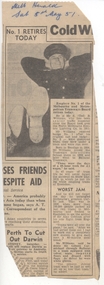
Yields information a former Ballarat driver who went to Melbourne and drove a specially fitted out tram car in Ballarat.Newspaper clipping from The Herald, Melbourne, Sat. 5/5/1951, titled "No. 1 Retires today", about the retirement of MMTB Employee No. 1, Mr. E (Ted) B. Williams after a 47 years on the trams. Worked in Bendigo, Ballarat, North Melbourne (NMETL), and MMTB. Senior Traffic Inspector. Lost a leg shunting trams at the Showgrounds. Contained originally within Reg Item 5623 at the front of this note book. For items see btm5623 loose items list.pdf.nmetl, bendigo, ballarat, mmtb, inspectors, retirements -
 Ballarat Tramway Museum
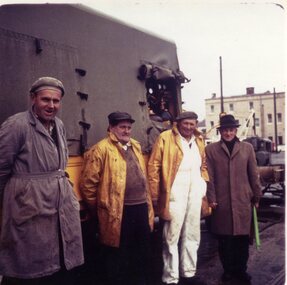
Photograph - Colour Print, Lilian Butler, Sep. 1971
Possibly has a strong association with the tram track and depot maintenance staff at the time of closure of the SEC operated Ballarat system.Colour print of a group of four SEC workers standing alongside the cloth covered SEC Ballarat Tramway track gang truck, in Lydiard St North, with the railway gates in the background. The man on the right hand side is holding a rolled up green flag. These workers were not included in the staff photo. Refer to track diaries in the collection for possible names. Item was placed in an envelope marked "Mr. Vermeend" - retained with photograph in storage folder. Photo printed on Kodak Paper. Photograph by Lilian Butler?in ink on rear " Lydiard St Nth Ballarat. With my compliments Lilian Butler"trams, tramways, sec, depot, trackwork, track, personnel -
 Ballarat Tramway Museum
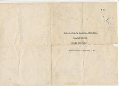
Ephemera - Timetable, State Electricity Commission of Victoria (SECV), "Ballarat Tramways - Revised Time Table as from Monday 14th May, 1956", May. 1956
Yields information about timetable for tram services in Ballarat for May 1956 and what routes were operated.Duplicated foolscap sheet titled "Ballarat Tramways - Revised Time Table as from Monday 14th May, 1956". Date of issue one side with the other side providing details of service for Week days, Saturdays and Sundays on the Sebastopol, Grey St, Lydiard St North, Victoria St, Mt Pleasant, Gardens via Drummond St, Haddon St, Gardens via Sturt St West, Sturt St West and View Point. Document headed :"State Electricity Commission of Victoria"ballarat, timetables, services -
 Ballarat Tramway Museum
Photograph - Black and White photograph/s - mounted, John Phillips, c1971
Yields information about trams used, services and buildings in Lydiard St North near the railway station c1971.Black and White photograph mounted on heavy cardboard backing. Photo of Ballarat No. 12 with destination of Grey St Sebastopol, with tram behind it, showing "Special" and another two single truckers behind No. 12 in Lydiard St North, just before the Railway level crossing. In the background are Victoria House, Moodys' Provincial Hotel and Ludbrook House. Has parts of old support tape on rear. Note image scanned in two runs through a scanner, resulting in the shading in the image file.trams, tramways, lydiard st, railway crossing, provincial hotel, tram 12, tram 21 -
 Ballarat Tramway Museum
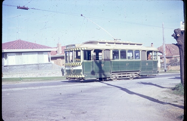
Photograph - Digital image, Joy Waller, 19/09/1971 12:00:00 AM
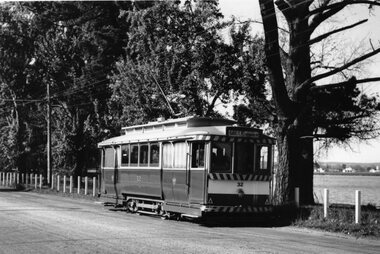
Copy of a colour slide showing Tram 17 in Lydiard Street North, at the terminus. From the direction of the trolley pole and the sign on the destination board, it is preparing to return to Sebastopol. One of the crew can be seen leaning on a fence in the background. Three brick veneer homes can be seen. The photographer says this was taken on the last day of trams in Lydiard Street in 1971. (More likely 17/9/1991 based on A Cook notes, 17 was not used on the last day, all bogie trams)trams, tramways, ballarat trams, crews, houses, last day, lydiard st nth, secv tramways, street scene, terminus, tramway closure, tram 17 -
 Ballarat Tramway Museum
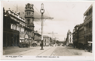
Photograph - Digital image, Rose Stereograph Co, c1930
Yields information the appearance of Lydiard St north, centre poles and buildings.Digital image from the Wal Jack Ballarat Album of Rose Series postcard No. P 1787, of Lydiard St North looking south from near Mair St. shows the centre poles prior to their removal. A number of motor cars are parked in the street, a dog on the right hand side, and ESCo tram has just rounded the corner and about to climb the small hill. Published by Rose Stereograph Co., Armadale Victoria. For rear of postcard - see image i2.in pencil on rear "Old type of electric tram"trams, tramways, esco, lydiard st, poles -
 Ballarat Tramway Museum
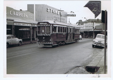
Photograph - Digital image, Wal Jack, 1/07/1961 12:00:00 AM
Yields information about the development of the development of the Main and Victoria St intersection, bogie trams and Stones Corner in 1961.Digital image from the Wal Jack Ballarat Album of a photograph of No.37 in bound from Mt Pleasant, in Main St, about to arrive at Stones Corner. Tram has the destination of Gardens via Drummond North. Photo Wal Jack taken on 1-7-1961. In the background are Stones, Treadwell carpets and Verna Cake shop. The mark on the photograph is from a photo corner that was stuck to the surface and the time of the scanning, after it became loose. See image i2 for rear of photograph.On rear of photograph in ink "SEC, Ballarat No. 37 (ex Bendigo No. 1) Main St, Ballarat East 1-7-61"trams, tramways, stones corner, main st, tram 37 -
 Ballarat Tramway Museum
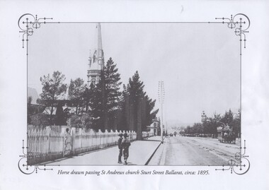
Photograph - Black & White Photograph/s, c1895
Demonstrates how tramway crew and Inspectors uniforms were to be worn during the summer and winter. Yields information about the actual uniforms themselves.Black and white historic photograph downloaded from a picture resource website within a decorative frame. Printed with an inkjet printer. Titled "Horse drawn passing St Andrews church Sturt St Ballarat, circa: 1895" Shows a horse drawn tram ascending Sturt St on the north side and St Andrews church. Note the wooden fence, the two boys on the footpath, and the telephone/telegraph poles. The Town Hall tower can be seen in the background. Original photo from a postcard?trams, tramways, sturt st, st andrews kirk, horse tram -
 Ballarat Tramway Museum
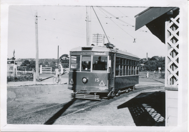
Photograph - Black & White Photograph/s, Wal Jack, 12/04/1950 12:00:00 AM
Black and White print contained within the Wal Jack Bendigo and Geelong Album, see Reg Item 5003 for more details. Photo of Bendigo Birney No.15 at North Bendigo, Photo Wal Jack, with the destination of Golden Square - 12-4-1959. Has the level crossing and rail line in the background and part of the tram stop shelter. i1 - scan of print in the album i2 - rear of image i3 - scan of negative at 3200dpi added 6/6/2020. On the rear in black ink "SEC Bendigo, No. 15 at Nth Bendigo 12-4-1959. Has the Wal Jack copyright stamp in the top right corner with the number "T219" written in.trams, tramways, bendigo, north bendigo, level crossings, birney, tram 15 -
 Ballarat Tramway Museum
Photograph - Black & White Photograph/s, c1928
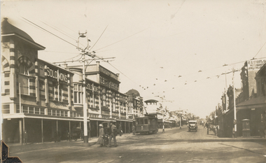
Black and White copy print contained within the Wal Jack Bendigo and Geelong Album, see Reg Item 5003 for more details. View of the intersection of Moorabool St and Malop St, photo from the North East corner. No. 4 MESCo, about 1928, heading south. Tram has the destination of Newtown. Solomons and E.G. Stott Jewellers and watchmakers buildings in the photo. Note the fire alarm, and letter box on the corner (right hand side of photo) Not known who made print. on rear in pencil "Newtown destination"trams, tramways, geelong, mesco, malop st, moorabool st, tram 4 -
 Bendigo Historical Society Inc.
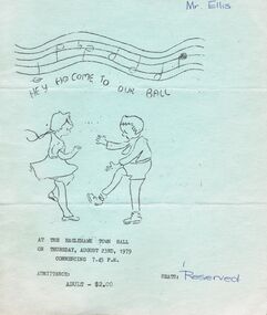
Document - PETER ELLIS COLLECTION: BENDIGO NORTH PRIMARY SCHOOL BALL, 23rd August, 1979
Light blue program for the Bendigo North Primary School ball held on Thursday, August 23rd, 1979 at the Eaglehawk Town Hall. Front page has a sketch of a boy and a girl dancing. The centre has a list of 18 dances, a mixture of Colonial, Ballroom and Folk Dances. The back page is the acknowledgements to: Esme Barker, Norman Powell, Jeanette Clancy, Elizabeth Lakey, Val Lee, Maurie Raynor, Peter Ellis, Sandhurst Dance Club. Written on the back is Maree Murrell.entertainment, dance, ball, peter ellis collection, eaglehawk town hall, bendigo north primary school, esme barker, norman powell, jeanette clancy, elizabeth lakey, val lee, maurie raynor, peter ellis, sandhurst dance club, maree murrell -
 Bayside Gallery - Bayside City Council Art & Heritage Collection
Photograph, Department of Crown Lands and Survey, Victoria, Melbourne Project: Brighton, 1976
The Department of Crown Lands and Survey (1857-1983) was responsible for the administration of survey and mapping and the sale, occupation and management of crown land throughout its existence. This aerial photograph shows parts of Brighton and was taken on 1 December 1976brighton, department of crown lands and survey, aerial photograph, bayside, port phillip bay, map, cartographic material, melbourne project 1976, brighton yacht club, middle brighton baths, north road, st kilda street, new street -
 Ballarat Tramway Museum
Slide - 35mm slide/s, Keith Kings, 7/01/1961 12:00:00 AM
Bendigo No. 6 arriving at Charing Cross ex North Bendigo, with 'Golden Square' destination. Tram has all blinds down, fitted with briquettes ad on front dash, has had bumper and top of roof painted with safety stripes, and under front window small white stripe has been painted, no lights as yet. On a centre of road pole, on a sign is 'ALL CARS STOP HERE'. Photo taken 7-1-1961. Photo by Keith Kings.Stamped on 'K.S.Kings etc' and in blue ink 'K(k)(329), 1/250,. f5.6, 7/1/61, Bendigo No. 6, ex Ballarat 25, at Charing Cross, in Pall Mall.'tramways, trams, bendigo, charing cross, pall mall, north bendigo, tram 6 -
 Tennis Australia
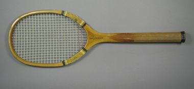
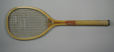
Racquet, Circa 1925
A wooden racquet with a concave throat, green-marbled, clear plastic shoulder supports, white and black whipping, and grooved handle. Inscription along the throat on obverse: SUPREME. Manufacturer's mark, featured on throat on reverse, comprises of the letter 'M' at the centre of a circular, banded shield. Inscription: N.J. MAGNAN CORP./NORTH ATTLEBORO,MASS,U.S.A. Manufacturer's details also feature across left side of stem. Materials: Wood, Nylon, String, Leather, Cloth, Metal, Glue, Lacquer, Ink, Plastictennis -
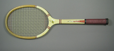 Tennis Australia
Racquet, Circa 1945
A wooden racquet, partially painted white,with red rubber gripped handle. Inscription across the throat on obverse, accompanied by an emblem of a male tennis player: EXPE[RT]. Manufacturer's emblem, featured on throat on reverse, comprises of text box framed by a ribboned wreath below, and a spread eagle above. Inscription: N.J. MAGNAN/CORP./NORTH ATTLEBORO/MASS. Materials: Wood, Nylon, String, Leather, Cloth, Metal, Glue, Lacquer, Ink, Plastic, Adhesive tape, Rubbertennis -
 Tennis Australia
Racquet, Circa 1906
A wooden, transitional flat-top racquet with a laminated convex throat. Decal profile bust image across throat on obverse is of a male North American native. Inscription across right side of stem is largely lost, but originally read: THE BRIDGEPORT GUN IMPLEMENT CO./NEW YORK, U.S.A. Hand carved name along stem on obverse: LOLA DEVALE. Decal inscription across crown on obverse is illegible. Materials: Wood, Gut, String, Leather, Metal, Ink, Glue, Lacquertennis -
 Kew Historical Society Inc
Map, MMBW, MMBW Plan No.64 Kew & Heidelberg, 1900-1910
The Melbourne and Metropolitan Board of Works (MMBW) was established by an act of the Victorian Parliament in 1890 to prepare for and to implement a sewerage and water reticulation system across what was then inner Melbourne, its surrounding and middle distance suburbs, including Kew. The MMBW was disbanded in 1991.The map collection of the Kew Historical Society has at its core the historic maps assembled and originally stored in the City Engineer's Department of the City of Kew. These include maps in a number of scales. The vast majority of maps were produced by the MMBW in the first two decades of the twentieth century, and are solid working maps, backed by linen for durability. These maps are historically significant to Kew, the City of Boroondara and to the history of the development of state utilities in Victoria. A number of the Kew maps have additional details added by former municipal officers, including the levels reached by various floods. As these were working documents, information was added to them long after the period of their initial production and distribution.Early map of part of the Borough of Kew, created in the first decade of the twentieth century, at a scale 160 ft to 1 inch. The map covers what was then the northern most part of Kew, bordered on its north and west by the Yarra River, in the East by Connor's Creek and by the Asylum in the south. The map shows the extent of urban development by that time, prominent institutions and the outlines of built structures in the municipality. Contour lines and historic flood levels were added in ink to the map at a later stage.MELBOURNE AND METROPOLITAN BOARD OF WORKS / PLAN NO. 64 / KEW & HEIDELBERGmelbourne & metropolitan board of works, mmbw maps, mmbw plans, borough of kew, cartography -
 Kew Historical Society Inc
Map, MMBW, MMBW Plan No.65 Kew & Heidelberg, 1900-1910
The Melbourne and Metropolitan Board of Works (MMBW) was established by an act of the Victorian Parliament in 1890 to prepare for and to implement a sewerage and water reticulation system across what was then inner Melbourne, its surrounding and middle distance suburbs, including Kew. The MMBW was disbanded in 1991.The map collection of the Kew Historical Society has at its core the historic maps assembled and originally stored in the City Engineer's Department of the City of Kew. These include maps in a number of scales. The vast majority of maps were produced by the MMBW in the first two decades of the twentieth century, and are solid working maps, backed by linen for durability. These maps are historically significant to Kew, the City of Boroondara and to the history of the development of state utilities in Victoria. A number of the Kew maps have additional details added by former municipal officers, including the levels reached by various floods. As these were working documents, information was added to them long after the period of their initial production and distribution.Early map of part of the Borough of Kew, created in the first decade of the twentieth century, at a scale 160 ft to 1 inch. The map covers what was then the south central part of Kew, bordered on its north by Malmsbury Street, in the west by Florence Avenue, in the south by Barkers Road, and in the east by Princess Street. The map shows the extent of urban development by that time, prominent institutions and the outlines of built structures in the municipality. Contour lines were added in ink to the map at a later stage.MELBOURNE AND METROPOLITAN BOARD OF WORKS / PLAN NO. 65 / KEW & HEIDELBERGmelbourne & metropolitan board of works, mmbw maps, mmbw plans, borough of kew, cartography -
 Kew Historical Society Inc
Map, MMBW, MMBW Plan No.66 Kew, 1900-1910
The Melbourne and Metropolitan Board of Works (MMBW) was established by an act of the Victorian Parliament in 1890 to prepare for and to implement a sewerage and water reticulation system across what was then inner Melbourne, its surrounding and middle distance suburbs, including Kew. The MMBW was disbanded in 1991.The map collection of the Kew Historical Society has at its core the historic maps assembled and originally stored in the City Engineer's Department of the City of Kew. These include maps in a number of scales. The vast majority of maps were produced by the MMBW in the first two decades of the twentieth century, and are solid working maps, backed by linen for durability. These maps are historically significant to Kew, the City of Boroondara and to the history of the development of state utilities in Victoria. A number of the Kew maps have additional details added by former municipal officers, including the levels reached by various floods. As these were working documents, information was added to them long after the period of their initial production and distribution.Early map of part of the Borough of Kew, created in the first decade of the twentieth century, at a scale 160 ft to 1 inch. The map covers what was then the south eastern part of Kew, bordered on its north by Adeney Avenue, in the west by Sackville Street, in the south by Barkers Road, and in the east by Burke Road. The map shows the extent of urban development by that time, prominent institutions and the outlines of built structures in the municipality. Contour lines were added in ink to the map at a later stage.MELBOURNE AND METROPOLITAN BOARD OF WORKS / PLAN NO. 66 / KEW melbourne & metropolitan board of works, mmbw maps, mmbw plans, borough of kew, cartography -
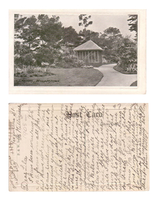 Williamstown Botanic Gardens- Hobsons Bay City Council
Postcard – Williamstown Botanic Gardens, c1900-1920
The original postcards in this series (2013.002 to 2013.018) were generously loaned to Williamstown Botanic Gardens by a private collector for copying. The postcards are evidence of the interest the gardens held as a subject for postcard publishers. The text and images provide a snapshot into fashions, social interests and concerns of the time. The professionally produced images provide a pictorial history of Gardens including changing planting styles, various structures and features of the Gardens eg the aviary, cannons, the fountain, the second Curator’s Lodge and gates. The images offer an opportunity to compare garden vistas with the present day. This card is a rare image of the original aviary built in the Gardens in 1892. The card also demonstrates how postcards were used as a method of contact in contrast to the contemporary use as souvenirs. The writer of the card, Polly, is anxious to receive a return postcard from Lila, writing that a reply should be sent that night. A black and white scene of a curving path with a square looking building at the centre. The 1894 MMBW plan shows that the building was triangular. The building is solid at ground level with the appearance of long vertical columns. The roof is light coloured and hip shaped with a finial at the apex. There is a garden set in the lawn on the left side of the image, shrubs and a palm at the left front corner of the building and tall trees in the background. The building is an aviary, which was built in north east section of the Gardens during 1892. The date of its removal is unknown. Front: ‘GARDENS, WILLIAMSTOWN’. Reverse: Centre top: ‘Post Card’; Vertical on left side: ‘P. & W. Series’; Right side ‘Address Only’. The card is addressed to Lila of ‘Ferguson St, N Williamstown’ from Polly. In pencil ‘1908 or later’ (believed to be inserted by the vendor of the card).postcard, gardens, post-card, williamstown-botanic-gardens, hobsons-bay-city-council, garden-path, aviary, 1908 -
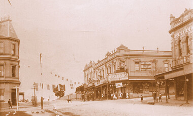 Surrey Hills Historical Society Collection
Photograph, Kenneth (Ken) Tudor Hall, Alfred Davies grocery store, corner Canterbury and Union Roads, 1906 or 1909, Original: 1906 or 1909; Copy photo by Ken Hall c1982
Ref: Mr & Mrs J Davies, Greensborough - Alfred Davies took over this store in 1904. He lived with his wife, Lucretia and 5 children above the store. His son Cyril recalled sleeping on the corner balcony on hot nights. Alfred Davies was a strong Temperance man and gave up the store when clients pressured him to collect their beer from the hotel opposite and deliver it with their grocery orders. The pharmacy moved across the road to this corner in 1936 when acquired by Dartnells. The corner shop in Woodheads building was a store and other businesses over the years. The "Druggist" on right, in Hansen's Exchange building, was established in 1889. From 1910 Percy Cathcart conducted the pharmacy there until 1936 when he was joined by Vic Dartnell, his cousin. In 1940, Vic transferred the business to Woodheads corner. His son John followed as a pharmacist until his daughter Amanda became the pharmacist. After the Dartnell family sold the business, the pharmacy continued in a similar manner as a compounding pharmacy and retained 'Dartnell' in its name.This documents the importance given to celebration of the British Empire in the Surrey Hills area in the first half of the 20th century. It also documents the earliest centre of business activity in the area with 2 major sets of dual occupancy residential and retail terraces - the Woodhead buildings and Hansen's Exchange, the later set of terraces having been demolished c1971.Sepia photo of the corner of Canterbury and Union Roads in 1906 or 1909 festooned with flags and lanterns for Empire Day celebrations. On the SE corner is Alfred Davies grocery store with advertising signs for Rosella jams and Southern Seas soap. There are people standing on a balcony above the Rosella advertising sign. Other adults and children stand in the street and there is a cab outside the draper's further east in Canterbury Road. On the opposite corner to Alfred Davies is a druggist and on the north-west corner is McNeil's Family Hotel.mcneil's family hotel, empire day, festivals and celebrations, grocers, pharmacists, alfred davies, businesses, woodhead's buildings, john woodhead, percy cathcart, hansen's exchange, hansen's folly -
 Federation University Art Collection
Artwork, other, Kristin McFarlane, 'Wings to Learning' by Kristin McFarlane, 2007, 2007
Kristin McFARLANE An Australian artist who combines graphic design, glass, botanical specimens, photography, encaustic painting, print and typography to explore fragility, nature and beauty. Kristin studied graphic design followed by a Graduate Diploma and Master of Fine Arts in glass at Monash University, Melbourne. Since graduating in 2004 she has undertaken public and private commissions and exhibitions including works for the Royal Melbourne Hospital, Monash University and Her Majesty Queen Rania of Jordan. Kristin designed and created the trophies for the Australian of The Year Awards from 2005-2014. These glass panels celebrate the history of the Monash University site; its early days as Berwick showgrounds and Casey Arifield to its current use as a state of the art educational centre. Images sourced from: Berwick Nostalgia, Early days o Berwick and its surrounding ditricts, Beaconsfield, Upper Beaconsfield, Harkaway, Narre Warren North, Berwick Mechanics Institute and Free Library and Monassh University archives. Federation University Australia took on the Berwick campus after Monash departed from the campusmonash university, casey airfield, berwick showgrounds, federation university berwick campus, berwick, fused glass -
 University of Melbourne, Burnley Campus Archives
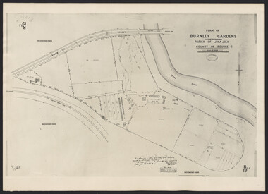
Photograph - Plan of Burnley Gardens
"This plan is a copy of a copy of the survey made by Mr. Turner in 1926. The original plan and field notes are missing _ file Rs 3529" Signed by _signature unreadable_ -
 Wodonga & District Historical Society Inc
Album - Hume Reservoir Australia Album - Earth embankment, Victoria, August 1927
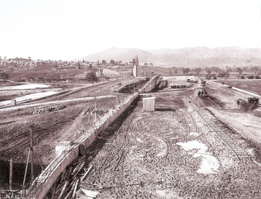
This set of photos is from a leather bound album bearing the inscription "HUME RESERVOIR AUSTRALIA" plus 'The Rt. Hon. L. C. M. S. Amery, P. C., M .P.' all inscribed in gold. It was presented to The Rt. Hon. L. C. M. S. Amery, P. C., M. P, Secretary of State for Dominion Affairs on the occasion of his visit to the Hume Reservoir on 2nd November 1927. This album is of local and national significance as it documents the planning and development of the Hume Reservoir up to 1927. It was the largest water reservoir in the British Empire. The album records the pioneering engineering work that went into its construction.DEPARTMENT OF PUBLIC WORKS, N.S.W. RIVER MURRAY WATERS SCHEME. HUME RESERVOIR. 32. Earth Embankment, Victoria. Looking down on the earth embankment and core wall. The earth is conveyed to the bank by rail, tipped out and then put in place by wheeled scoops, the horses and wheels treading and rolling the material into a very compact form while hoses play water on the mass to keep it moist. The concrete pillar with Tail Tower, and North Wing Wall, look very small in the distance. August 1927.hume reservoir australia, river murray waters scheme, hume reservoir construction -
 Wodonga & District Historical Society Inc
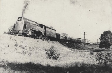
Photograph - Fred Rochow Railways Collection - S Class Locomotive, C. 1960s
The Fred Rochow Railways Collection incorporates photos related to the operation of the Wodonga Railway Station including different types of trains and railways staff C. 1930 – 1990. It was donated to the Wodonga Historical Society by Fred Rochow, a railwayman who spent many years based in Wodonga. He joined the Victorian Railways on 17th June l947 and retired in 1988. For some time, he was a member of the Australian Federated Union of Locomotive Enginemen and served a term as a member of the Trades Hall Council. He had an extensive knowledge of the struggles that took place to achieve better conditions for railway workers. Fred worked for many years as a fireman and then worked his way up the ranks to driver, experiencing many changes from the days of steam locomotives through to diesel trains, locomotives and even the modern XPT train. He worked throughout Victoria at different stages of his career, with his final working years focused on the northeast of Victoria and the Albury to Melbourne line. After his retirement, Fred continued to share his love of steam miniature trains with the community.This collection has local and statewide significance as it captures images of trains, locomotives and personnel who operated the railway services in Wodonga and throughout Northeast Victoria. The railways played a critical role in opening up Victoria and connecting Australia for trade, business, social communication and transport.An S Class locomotive pulling a goods train into Wodonga in its last days before being scrapped. S Class Diesel Locomotives The eighteen members of the S Class were ordered in two batches by the Victorian Railways from Clyde Engineering for express passenger and freight workings, with the final eight locomotives ordered specifically to work the North-East standard gauge line. Many were named after prominent Victorians. They were introduced into service about 1957railways wodonga, fred rochow, wodonga railwaymen, s class locomotive -
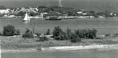 Lakes Entrance Historical Society
Photograph - Carpentertown, 1920c
Copied from copy in J Whadcoat collectionBlack and white photograph showing P W D cottage on left and other Works buildings on dune at the entrance to Gippsland Lakes from the ocean - Bass Strait. View shows flagstaff on top of dune and flagstaff jetty in lake - Cunninghame Arm. Small sailing boat on left and other small craft on shoreline. Section of Bullock Island with vegetation, one telegraph pole and one dead tree on island. Shoreline of North arm in foreground. Lakes Entrance Victoriajetties, waterways, settlement, historic site, boats and boating -
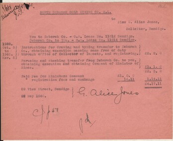 Bendigo Historical Society Inc.
Document - MISS G ALICE JONES COLLECTION: ACCOUNT
North Deborah Gold Mining Co. N. L. to Miss G. Alice Jones. Pink paper dated Oct. 9, 1939, to Mar 5, 1940, and 28 May 1940. Re You to Deborah Co. - G. M. Lease No. 11012 Bendigo. Deborah Co. to You. - G. M. Lease No. 11014 Bendigo. Account is for work involved in transferring leases to each other. Total cost £4.17.11. "R688 delivered 29/5/40" written in the top left corner.miss g alice jones - solicitor - account, north deborah gold mining co n l, deborah co