Showing 25992 items matching "weatherly-library"
-
 Flagstaff Hill Maritime Museum and Village
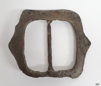
Equipment - Harness Buckle, Ca. 1855
Harness fittings like this buckle were amongst the cargo on the sailing ship Schomberg. ABOUT THE SCHOMBERG (October 6 to December 27, 1855)- When the ship Schomberg was launched in 1855, she was considered the most perfect clipper ship ever to be built. James Baine’s Black Ball Line had commissioned her for their fleet of passenger liners. The Aberdeen builders designed her to sail faster than the clippers designed the three-masted wooden clipper ship to be fast. The timber used for the diagonal planking was British oak with layers of Scottish larch. This luxury emigrant vessel was designed for superior comfort. She had ventilation ducts to provide air to the lower decks and a dining saloon, smoking room, library and bathrooms for the first-class passengers. The master for Schomberg’s maiden voyage was Captain ‘Bully’ Forbes. He drunkenly predicted at her launch that he would make the journey between Liverpool and Melbourne in 60 days. Schomberg departed Liverpool on 6 October 1855 with 430 passengers and 3000 tons of cargo including iron rails and equipment intended the build the Geelong Railway and a bridge over the Yarra from Melbourne to Hawthorn. The poor winds slowed Schomberg’s sail across the equator. She was 78 days out of Liverpool when she ran aground on a sand spit near Peterborough, Victoria, on 27 December; the sand spit and currents were not marked on Forbes’s map. The ship’s Chief Officer spotted the coastal steamer SS Queen at dawn and sent a signal. The master of the SS Queen approached the stranded vessel and all of Schomberg’s passengers safely disembarked. In 1975, 120 years after the Schomberg was wrecked, divers from Flagstaff Hill found an ornate communion set at the wreck site along with many other artefacts. In 1978 a diamond ring was discovered under the concretion in the lid of the communion set, which is currently on display. Former Director of Flagstaff Hill, Peter Ronald, had salvaged most of the artefacts from the wreck.This object is significant as an example of an item in common use in the mid-19th century. The Schomberg collection as a whole is of historical and archaeological significance at a State level. Flagstaff Hill’s collection of artefacts from the Schomberg is also significant for its association with the Victorian Heritage Registered shipwreck (VHR S 612). The collection is of prime significance because of the relationship between the objects salvaged, as together they help us to interpret the story of the Schomberg. The collection as a whole is historically significant for representing aspects of Victoria's maritime history and its potential to interpret social and historical themes.Buckle, square, large, for a horse harness. The silver-plated surface has damage from exposure to the sea. It has been lacquered since its recovery from the wreck of the Schomberg.flagstaff hill, flagstaff hill maritime museum and village, warrnambool, maritime museum, maritime village, great ocean road, shipwreck coast, schomberg, 1855, clipper ship, james baines & co, black ball line, luxury ship, emigrant ship, captain forbes, bully forbes, ss queen, peterborough shipwreck, harnes fitting, horse brass, buckle, horse harness, horse harness buckle -
 Flagstaff Hill Maritime Museum and Village
Equipment - Harness Buckle, Ca. 1855
Harness fittings like this buckle were amongst the cargo on the sailing ship Schomberg. ABOUT THE SCHOMBERG (October 6 to December 27, 1855)- When the ship Schomberg was launched in 1855, she was considered the most perfect clipper ship ever to be built. James Baine’s Black Ball Line had commissioned her for their fleet of passenger liners. The Aberdeen builders designed her to sail faster than the clippers designed the three-masted wooden clipper ship to be fast. The timber used for the diagonal planking was British oak with layers of Scottish larch. This luxury emigrant vessel was designed for superior comfort. She had ventilation ducts to provide air to the lower decks and a dining saloon, smoking room, library and bathrooms for the first-class passengers. The master for Schomberg’s maiden voyage was Captain ‘Bully’ Forbes. He drunkenly predicted at her launch that he would make the journey between Liverpool and Melbourne in 60 days. Schomberg departed Liverpool on 6 October 1855 with 430 passengers and 3000 tons of cargo including iron rails and equipment intended the build the Geelong Railway and a bridge over the Yarra from Melbourne to Hawthorn. The poor winds slowed Schomberg’s sail across the equator. She was 78 days out of Liverpool when she ran aground on a sand spit near Peterborough, Victoria, on 27 December; the sand spit and currents were not marked on Forbes’s map. The ship’s Chief Officer spotted the coastal steamer SS Queen at dawn and sent a signal. The master of the SS Queen approached the stranded vessel and all of Schomberg’s passengers safely disembarked. In 1975, 120 years after the Schomberg was wrecked, divers from Flagstaff Hill found an ornate communion set at the wreck site along with many other artefacts. In 1978 a diamond ring was discovered under the concretion in the lid of the communion set, which is currently on display. Former Director of Flagstaff Hill, Peter Ronald, had salvaged most of the artefacts from the wreck.This object is significant as an example of an item in common use in the mid-19th century. The Schomberg collection as a whole is of historical and archaeological significance at a State level. Flagstaff Hill’s collection of artefacts from the Schomberg is also significant for its association with the Victorian Heritage Registered shipwreck (VHR S 612). The collection is of prime significance because of the relationship between the objects salvaged, as together they help us to interpret the story of the Schomberg. The collection as a whole is historically significant for representing aspects of Victoria's maritime history and its potential to interpret social and historical themes.Buckle for a horse harness. The silver-plated surface has been damaged from exposure to the sea. It has been lacquered since its recovery from the wreck of the Schomberg.flagstaff hill, flagstaff hill maritime museum and village, warrnambool, maritime museum, maritime village, great ocean road, shipwreck coast, schomberg, 1855, clipper ship, james baines & co, black ball line, luxury ship, emigrant ship, captain forbes, bully forbes, ss queen, peterborough shipwreck, harnes fitting, horse brass, buckle, horse harness, horse harness buckle -
 Flagstaff Hill Maritime Museum and Village
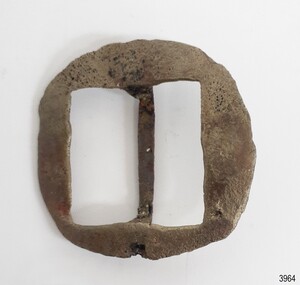
Equipment - Harness Buckle, Ca. 1855
Harness fittings like this buckle were amongst the cargo on the sailing ship Schomberg. ABOUT THE SCHOMBERG (October 6 to December 27, 1855)- When the ship Schomberg was launched in 1855, she was considered the most perfect clipper ship ever to be built. James Baine’s Black Ball Line had commissioned her for their fleet of passenger liners. The Aberdeen builders designed her to sail faster than the clippers designed the three-masted wooden clipper ship to be fast. The timber used for the diagonal planking was British oak with layers of Scottish larch. This luxury emigrant vessel was designed for superior comfort. She had ventilation ducts to provide air to the lower decks and a dining saloon, smoking room, library and bathrooms for the first-class passengers. The master for Schomberg’s maiden voyage was Captain ‘Bully’ Forbes. He drunkenly predicted at her launch that he would make the journey between Liverpool and Melbourne in 60 days. Schomberg departed Liverpool on 6 October 1855 with 430 passengers and 3000 tons of cargo including iron rails and equipment intended the build the Geelong Railway and a bridge over the Yarra from Melbourne to Hawthorn. The poor winds slowed Schomberg’s sail across the equator. She was 78 days out of Liverpool when she ran aground on a sand spit near Peterborough, Victoria, on 27 December; the sand spit and currents were not marked on Forbes’s map. The ship’s Chief Officer spotted the coastal steamer SS Queen at dawn and sent a signal. The master of the SS Queen approached the stranded vessel and all of Schomberg’s passengers safely disembarked. In 1975, 120 years after the Schomberg was wrecked, divers from Flagstaff Hill found an ornate communion set at the wreck site along with many other artefacts. In 1978 a diamond ring was discovered under the concretion in the lid of the communion set, which is currently on display. Former Director of Flagstaff Hill, Peter Ronald, had salvaged most of the artefacts from the wreck.This object is significant as an example of an item in common use in the mid-19th century. The Schomberg collection as a whole is of historical and archaeological significance at a State level. Flagstaff Hill’s collection of artefacts from the Schomberg is also significant for its association with the Victorian Heritage Registered shipwreck (VHR S 612). The collection is of prime significance because of the relationship between the objects salvaged, as together they help us to interpret the story of the Schomberg. The collection as a whole is historically significant for representing aspects of Victoria's maritime history and its potential to interpret social and historical themes.Buckle for a horse harness, square. The silver-plated surface has damage from exposure to the sea. It has been lacquered since its recovery from the wreck of the Schomberg.flagstaff hill, flagstaff hill maritime museum and village, warrnambool, maritime museum, maritime village, great ocean road, shipwreck coast, schomberg, 1855, clipper ship, james baines & co, black ball line, luxury ship, emigrant ship, captain forbes, bully forbes, ss queen, peterborough shipwreck, harnes fitting, horse brass, buckle, horse harness, horse harness buckle -
 Flagstaff Hill Maritime Museum and Village
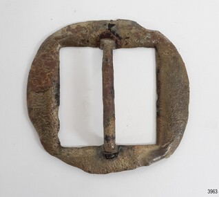
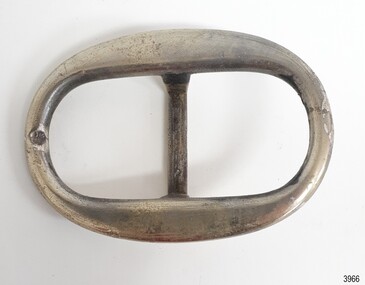
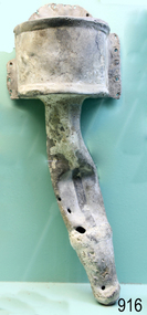
Equipment - Harness Buckle, Alexander Hall and Son, Ca. 1855
Harness fittings like this buckle were amongst the cargo on the sailing ship Schomberg. ABOUT THE SCHOMBERG (October 6 to December 27, 1855)- When the ship Schomberg was launched in 1855, she was considered the most perfect clipper ship ever to be built. James Baine’s Black Ball Line had commissioned her for their fleet of passenger liners. The Aberdeen builders designed her to sail faster than the clippers designed the three-masted wooden clipper ship to be fast. The timber used for the diagonal planking was British oak with layers of Scottish larch. This luxury emigrant vessel was designed for superior comfort. She had ventilation ducts to provide air to the lower decks and a dining saloon, smoking room, library and bathrooms for the first-class passengers. The master for Schomberg’s maiden voyage was Captain ‘Bully’ Forbes. He drunkenly predicted at her launch that he would make the journey between Liverpool and Melbourne in 60 days. Schomberg departed Liverpool on 6 October 1855 with 430 passengers and 3000 tons of cargo including iron rails and equipment intended the build the Geelong Railway and a bridge over the Yarra from Melbourne to Hawthorn. The poor winds slowed Schomberg’s sail across the equator. She was 78 days out of Liverpool when she ran aground on a sand spit near Peterborough, Victoria, on 27 December; the sand spit and currents were not marked on Forbes’s map. The ship’s Chief Officer spotted the coastal steamer SS Queen at dawn and sent a signal. The master of the SS Queen approached the stranded vessel and all of Schomberg’s passengers safely disembarked. In 1975, 120 years after the Schomberg was wrecked, divers from Flagstaff Hill found an ornate communion set at the wreck site along with many other artefacts. In 1978 a diamond ring was discovered under the concretion in the lid of the communion set, which is currently on display. Former Director of Flagstaff Hill, Peter Ronald, had salvaged most of the artefacts from the wreck.This object is significant as an example of an item in common use in the mid-19th century. The Schomberg collection as a whole is of historical and archaeological significance at a State level. Flagstaff Hill’s collection of artefacts from the Schomberg is also significant for its association with the Victorian Heritage Registered shipwreck (VHR S 612). The collection is of prime significance because of the relationship between the objects salvaged, as together they help us to interpret the story of the Schomberg. The collection as a whole is historically significant for representing aspects of Victoria's maritime history and its potential to interpret social and historical themes.Buckle for a horse harness, oval. The silver-plated surface has damage from exposure to the sea. It has been lacquered since its recovery from the wreck of the Schomberg.flagstaff hill, flagstaff hill maritime museum and village, warrnambool, maritime museum, maritime village, great ocean road, shipwreck coast, schomberg, 1855, clipper ship, james baines & co, black ball line, luxury ship, emigrant ship, captain forbes, bully forbes, ss queen, peterborough shipwreck, harnes fitting, horse brass, buckle, horse harness, horse harness buckle -
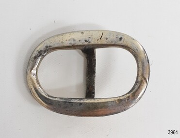
 Flagstaff Hill Maritime Museum and Village
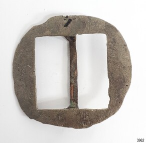
Equipment - Harness Buckle, Ca. 1855
Harness fittings like this buckle were amongst the cargo on the sailing ship Schomberg. ABOUT THE SCHOMBERG (October 6 to December 27, 1855)- When the ship Schomberg was launched in 1855, she was considered the most perfect clipper ship ever to be built. James Baine’s Black Ball Line had commissioned her for their fleet of passenger liners. The Aberdeen builders designed her to sail faster than the clippers designed the three-masted wooden clipper ship to be fast. The timber used for the diagonal planking was British oak with layers of Scottish larch. This luxury emigrant vessel was designed for superior comfort. She had ventilation ducts to provide air to the lower decks and a dining saloon, smoking room, library and bathrooms for the first-class passengers. The master for Schomberg’s maiden voyage was Captain ‘Bully’ Forbes. He drunkenly predicted at her launch that he would make the journey between Liverpool and Melbourne in 60 days. Schomberg departed Liverpool on 6 October 1855 with 430 passengers and 3000 tons of cargo including iron rails and equipment intended the build the Geelong Railway and a bridge over the Yarra from Melbourne to Hawthorn. The poor winds slowed Schomberg’s sail across the equator. She was 78 days out of Liverpool when she ran aground on a sand spit near Peterborough, Victoria, on 27 December; the sand spit and currents were not marked on Forbes’s map. The ship’s Chief Officer spotted the coastal steamer SS Queen at dawn and sent a signal. The master of the SS Queen approached the stranded vessel and all of Schomberg’s passengers safely disembarked. In 1975, 120 years after the Schomberg was wrecked, divers from Flagstaff Hill found an ornate communion set at the wreck site along with many other artefacts. In 1978 a diamond ring was discovered under the concretion in the lid of the communion set, which is currently on display. Former Director of Flagstaff Hill, Peter Ronald, had salvaged most of the artefacts from the wreck.This object is significant as an example of an item in common use in the mid-19th century. The Schomberg collection as a whole is of historical and archaeological significance at a State level. Flagstaff Hill’s collection of artefacts from the Schomberg is also significant for its association with the Victorian Heritage Registered shipwreck (VHR S 612). The collection is of prime significance because of the relationship between the objects salvaged, as together they help us to interpret the story of the Schomberg. The collection as a whole is historically significant for representing aspects of Victoria's maritime history and its potential to interpret social and historical themes.Horse harness buckle, plated brass, oval shape. Recovered from the wreck of the Schomberg.flagstaff hill, flagstaff hill maritime museum and village, warrnambool, maritime museum, maritime village, great ocean road, shipwreck coast, schomberg, 1855, clipper ship, james baines & co, black ball line, luxury ship, emigrant ship, captain forbes, bully forbes, ss queen, peterborough shipwreck, harnes fitting, horse brass, buckle, horse harness, horse harness buckle, silver plated buckle -
 Flagstaff Hill Maritime Museum and Village
Equipment - Harness Buckle, Alexander Hall and Son, Ca. 1855
Harness fittings like this buckle were amongst the cargo on the sailing ship Schomberg. ABOUT THE SCHOMBERG (October 6 to December 27, 1855)- When the ship Schomberg was launched in 1855, she was considered the most perfect clipper ship ever to be built. James Baine’s Black Ball Line had commissioned her for their fleet of passenger liners. The Aberdeen builders designed her to sail faster than the clippers designed the three-masted wooden clipper ship to be fast. The timber used for the diagonal planking was British oak with layers of Scottish larch. This luxury emigrant vessel was designed for superior comfort. She had ventilation ducts to provide air to the lower decks and a dining saloon, smoking room, library and bathrooms for the first-class passengers. The master for Schomberg’s maiden voyage was Captain ‘Bully’ Forbes. He drunkenly predicted at her launch that he would make the journey between Liverpool and Melbourne in 60 days. Schomberg departed Liverpool on 6 October 1855 with 430 passengers and 3000 tons of cargo including iron rails and equipment intended the build the Geelong Railway and a bridge over the Yarra from Melbourne to Hawthorn. The poor winds slowed Schomberg’s sail across the equator. She was 78 days out of Liverpool when she ran aground on a sand spit near Peterborough, Victoria, on 27 December; the sand spit and currents were not marked on Forbes’s map. The ship’s Chief Officer spotted the coastal steamer SS Queen at dawn and sent a signal. The master of the SS Queen approached the stranded vessel and all of Schomberg’s passengers safely disembarked. In 1975, 120 years after the Schomberg was wrecked, divers from Flagstaff Hill found an ornate communion set at the wreck site along with many other artefacts. In 1978 a diamond ring was discovered under the concretion in the lid of the communion set, which is currently on display. Former Director of Flagstaff Hill, Peter Ronald, had salvaged most of the artefacts from the wreck.This object is significant as an example of an item in common use in the mid-19th century. The Schomberg collection as a whole is of historical and archaeological significance at a State level. Flagstaff Hill’s collection of artefacts from the Schomberg is also significant for its association with the Victorian Heritage Registered shipwreck (VHR S 612). The collection is of prime significance because of the relationship between the objects salvaged, as together they help us to interpret the story of the Schomberg. The collection as a whole is historically significant for representing aspects of Victoria's maritime history and its potential to interpret social and historical themes.Buckle for a horse harness, square. The silver-plated surface has damage from exposure to the sea. It has been lacquered since its recovery from the wreck of the Schomberg.flagstaff hill, flagstaff hill maritime museum and village, warrnambool, maritime museum, maritime village, great ocean road, shipwreck coast, schomberg, 1855, clipper ship, james baines & co, black ball line, luxury ship, emigrant ship, captain forbes, bully forbes, ss queen, peterborough shipwreck, harnes fitting, horse brass, buckle, horse harness, horse harness buckle -
 Flagstaff Hill Maritime Museum and Village
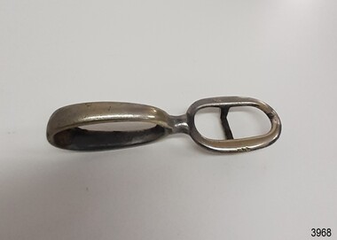
Equipment - Harness Buckle, Alexander Hall and Son, Ca. 1855
Harness fittings like this buckle were amongst the cargo on the sailing ship Schomberg. ABOUT THE SCHOMBERG (October 6 to December 27, 1855)- When the ship Schomberg was launched in 1855, she was considered the most perfect clipper ship ever to be built. James Baine’s Black Ball Line had commissioned her for their fleet of passenger liners. The Aberdeen builders designed her to sail faster than the clippers designed the three-masted wooden clipper ship to be fast. The timber used for the diagonal planking was British oak with layers of Scottish larch. This luxury emigrant vessel was designed for superior comfort. She had ventilation ducts to provide air to the lower decks and a dining saloon, smoking room, library and bathrooms for the first-class passengers. The master for Schomberg’s maiden voyage was Captain ‘Bully’ Forbes. He drunkenly predicted at her launch that he would make the journey between Liverpool and Melbourne in 60 days. Schomberg departed Liverpool on 6 October 1855 with 430 passengers and 3000 tons of cargo including iron rails and equipment intended the build the Geelong Railway and a bridge over the Yarra from Melbourne to Hawthorn. The poor winds slowed Schomberg’s sail across the equator. She was 78 days out of Liverpool when she ran aground on a sand spit near Peterborough, Victoria, on 27 December; the sand spit and currents were not marked on Forbes’s map. The ship’s Chief Officer spotted the coastal steamer SS Queen at dawn and sent a signal. The master of the SS Queen approached the stranded vessel and all of Schomberg’s passengers safely disembarked. In 1975, 120 years after the Schomberg was wrecked, divers from Flagstaff Hill found an ornate communion set at the wreck site along with many other artefacts. In 1978 a diamond ring was discovered under the concretion in the lid of the communion set, which is currently on display. Former Director of Flagstaff Hill, Peter Ronald, had salvaged most of the artefacts from the wreck.This object is significant as an example of an item in common use in the mid-19th century. The Schomberg collection as a whole is of historical and archaeological significance at a State level. Flagstaff Hill’s collection of artefacts from the Schomberg is also significant for its association with the Victorian Heritage Registered shipwreck (VHR S 612). The collection is of prime significance because of the relationship between the objects salvaged, as together they help us to interpret the story of the Schomberg. The collection as a whole is historically significant for representing aspects of Victoria's maritime history and its potential to interpret social and historical themes.Horse harness buckle, plated brass, two oval shapes joined at a 180 degrees angle on one of the short sides. One ring has a bar between the long sides. Recovered from the wreck of the Schomberg.flagstaff hill, flagstaff hill maritime museum and village, warrnambool, maritime museum, maritime village, great ocean road, shipwreck coast, schomberg, 1855, clipper ship, james baines & co, black ball line, luxury ship, emigrant ship, captain forbes, bully forbes, ss queen, peterborough shipwreck, harnes fitting, horse brass, buckle, horse harness, horse harness buckle -
 City of Moorabbin Historical Society (Operating the Box Cottage Museum)
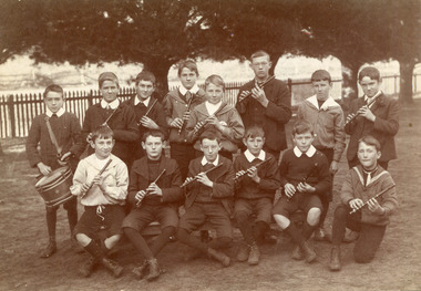
Photograph,Black & White Cheltenham State School Fife & Drum Band c1908, c1908
1855 Stephen Charman donated land to the Methodist Church so that a School could be established to educate the children of the early settler market gardeners and farmers in the Cheltenham area . Education was valued by the general community and as well as schools they established mechanics Institutes and Libraries in Moorabbin Shire. Cheltenham State School No. 84 was among the first schools in Melbourne. Stephen Charman, 1821-1906 a market gardener, donated land for the first Methodist Chapel, Cemetery and School in Charman Rd Cheltenham 1855. The enrolment was 36 pupils with Mr Frederick Meeres as Teacher. 1863 the school is called Beaumaris Common School No 84 with 70 pupils and Walter Meeres as Teacher. 1869 another 2 acres in Charman Road were granted by the Education Board and brick building built . 1872 State School 84 Beaumaris was increasing enrollments and 1878 a new brick school was built to accommodate 174 pupils and the name changed to Cheltenham State School No.84 1894 Mentone State School No.2950 amalgamated with Cheltenham SS No.84. 1910 the buildings were in disrepair, overcrowding was increasing and renovations were made 1912 with further additions in 1925 and 1937. Post WW11 extra prefabricated Classrooms were added as enrollment increased to 1038 in 1955.. Cheltenham East State School 4754 was opened as housing development spread over the City of Moorabbin . (J.Larson Sandringham HS) Probably due to the Scottish heritage of many early settlers the Fife & Drum Band was established at the West Beaumaris (Cheltenham) State School . The Fife is similar to the piccolo, and usually made of wood, consisting of a tube with 6 finger holes and an embouchure hole that produces sound when blown across.The fife was used in folk music traditions to accompany dancing by all social classes. Also in the Military where drums accompanied the fife and originally these 'boy soldier ' bands were used to signal manouevres in the field for the infantry. Later Fife & Drum bands were used for marching bands in schools and community groups, 1855 Stephen Charman donated land to the Methodist Church so that a School could be established to educate the children of the early settler market gardeners and farmers in the Cheltenham area . Education was valued by the general community and as well as schools they established mechanics Institutes and Libraries in Moorabbin Shire. Cheltenham State School No. 84 was among the first schools in Melbourne.Black & White photograph of pupils at West Beaumaris (Cheltenham) State School No.84 in the boy's Fife and Drum Band c 1908Back Handwritten Mrs Whelan / Beaumariswhelan r, marriott geoff, meeres frederick, cheltenham state school no.84, education, keys robert, holloway josiah, king brothers, smith j l; smith mary ann, stanley helen, chaff cutter, horse drawn carts, toll gates brighton, motor cars 1900, steam engines, early settlers, bentleigh, parish of moorabbin, city of moorabbin, county of bourke, moorabbin roads board, shire of moorabbin, henry dendy's special survey 1841, were j.b.; bent thomas, o'shannassy john, king richard, charman stephen, highett william, ormond francis, maynard dennis, market gardeners, vineyards, orchards -
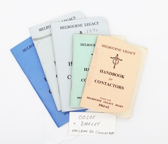 Melbourne Legacy
Booklet, Handbook for Contactors, 1x1959, 1x1961, 1x1996, 2x1972
A handbook is issued to all Legatees to assist them with their work with the legacy widows; eg childrens' education, welfare, accommodation, health. A quick easy guide to services provided by Melbourne Legacy such as bursaries, medical care, financial assistance etc for Legatees use. It was reissued annually for many years prior to keeping this information electronically. Many issues are held at 00002 and 01080. Chapters of the book include the following, many of which are committees: Administration Anzac Day Observance Comradeship. 'Comradeship is an integral and important part of Legacy. This committee's function is primarily to arrange social and other activities which bring members together so that they become known to each other on an intimate and friendly basis; and so that when a member strikes a problem, he immediately knows with whom he might get into touch to discuss it in then spirit of mutual assistance.' Finance Huntingdale (Golf Club) Intermediate Legacy Liaison Personnel Committee Programme Committee Dealing with the Junior Legacy Committee: Boys' Group Camps and holidays Christmas party Contact Cultural and Library Dental Demonstration Education Employment Firewood Girls' Group Housing and accomodation Legal Longbank (holiday home for widows in need of a rest) Medical Newsletter Older widows Optometrists Pensions Probation Residences Special cases Welfare Appendix A Allowances for school requisites Appendix B Scholarships Appendix C Pensions / War widows pensions / Commonwealth widows pensions / Immediate assistance SCTF Appendix D Repatriation Department Appendix E Commonwealth Social Services Appendix F CWD - Children's Welfare Department Appendix G Hospital and medical benefits for Legacy Widows and their dependants Appendix H AMF Relief Trust Fund Appendix I SCTF - Services Canteen Trust Fund Appendix J Sir Samuel McCaughey Bequest Appendix K Various sources of assistance available (eg clothing, blankets, POW associations, RSL, conveyance allowances.)This booklet assisted legatees locating services available to widows and children from within Legacy or government departments.Five copies of the Handbook for Contactors. Different covers from different dates, 1 green, 1 apricot, 2 grey, 1 blue.2 x Melbourne Legacy, Legacy logo, Handbook for Contactors, Issued with Melbourne Legacy Diary 1959/1961-62. 2 x Melbourne Legacy, Legacy logo Handbook for Contactors, For use in conjunction with Melbourne Legacy Diary 1972. 1 x Melbourne Legacy, Legacy logo, Handbook for Contactors, For use in conjunction with Melbourne Legacy Diary 1966.regulations, objectives, rules, register -
 Bendigo Historical Society Inc.
Slide - Images by Arthur Pulfer, 1957-1970
ROSEVIEW 407 High Street, Golden Square Bendigo "Roseview" was designed by Godfrey Eathorne and constructed in 1939. It is one of the few Streamline Moderne houses in the Central Goldfields region, and was one of the earliest constructed in the Bendigo region. It is an outstanding example of this style of housing. It resembles an ocean liner, and reflects the emphasis on the streamlining of methods of transportation. It utilizes both flat and curved surfaces and has little external ornamentation. The use of materials such as rounded glass windows and metal window and door frames reflects an innovative approach to construction consistent with the style. "Roseview" was constructed on a large scale, with large and spacious rooms. It reflects the prominent social status and wealth of the original owner, together with the desire for a building in 'the latest' style which was sure to attract attention and prominence in the region. It has been maintained largely in original condition. CARALULUP HOTEL 'The Sun' dated January 17, 1941 on the back. It states that 'The licence of Caralulup Hotel, near Talbot, has been surrendered, thus severing an 80 year association with the district' State Library of Victoria TOLMER GOLD ESCORT ROUTE The gold rush in New South Wales and Victoria left few able miners in South Australia. Bad economic conditions saw more than 15,000 men leave the Kapunda and Burra mines by the end of 1851. Alexander Tolmer, Commissioner of Police in 1852 proposed that the gold won by South Australians should be brought back to South Australia under an escort consisting of only a few men. In March a Gold Escort was on its way back to Adelaide with almost 6,000 ounces of gold for the vaults of the Treasury Building. After this successful trip Tolmer led two other escorts before handing over his duties. A total of eighteen gold escorts were made, the last one during November and December 1853 when Inspector Wyndham was in charge. You’ll find Gold Escort Route Monuments between Meningie, Coonalpyn and Tintinara.Many images from by Arthur Pulfer copied to slides. Twenty Slides of Bendigo: Bullen's Circus Bendigo February 1966 "Roseview", Pethard's Home at 407 High Street, Golden Square, Bendigo. 25th March 1957. House is possibly on the Midland Highway Epsom, Bendigo - 8 April 1955 Kangaroo Flat Bus Lines mini bus The Big Tree Sedgwick Road March 1972 The old Golden Gully Hotel Diamond Hill Road, Bendigo The old Lockup Eaglehawk Bendigo September 1967 Market Gardens - possibly North Bendigo North Deborah Mine photo taken from Breen Street 1958 Laying the track to get the engine into the park, looking down Mitchell Street Bendigo Engine R766 in the Victorian Railways Institute Park Railway Place Bendigo On the Methodist Church Steps Arnold street Bendigo Miner's Hut at Moliagul Basket Lunch - White Hills Botanical Gardens - St johns 100 year celebrations White Hills Swimming Pool February 1970 White Hills Botanical Gardens Bendigo Bendigo Show Parade 1958 The Arrival of the Cobb and Co Coach in Bendigo September 1963 history, bendigo, james lerk collection, golden square high school, dragon loong, white hill botanical gardens, 407 high street bendigo, r766 engine, bullens circus, caralulup, moligual, bendigo show, tolmer's gold route, kangaroo flat bus lines, eaglehawk lockup, arnold street methodist church, elephants -
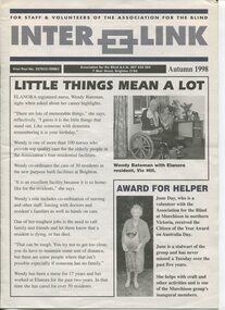 Vision Australia
Magazine - Text, Inter Link Autumn 1998
Newsletter created to share information between branches, staff and volunteers on achievements at the AFB. This issue includes: Wendy Bateman and her role as an Elanora nurse, volunteer June Day receiving the Citizen of the Year award for Murchison on Australia Day, Victoria's triumphant blind bowls team who, when tied with their SA competitors, decided to share the Catchpole trophy by keeping it for 12 months then sending it back to South Australia for 12 months, Julie Deutscher has won the tender to clean Kelaston, staff members Margaret Caldwell, Ada Fox, Maureen Gleeson and Lorelle McGain have completed five years of service with the AFB, Gale Burns, Glenys Drewitt, Fiona Jackson, Gena Kyne, Anne Menzel and Margaret Tozer have completed 10 years of service and Margary Paynter has completed 15 years of service with the AFB, Dennis Smith from the George Vowell Centre helping out as barman and waiter, RPH volunteers David Ditchfield and wife Janet received a special award for their service to the station, Judy Sutherland, Chrisi Tsafso and Jo Sisley were present for awards handed to police who had held a self defence course for vision impaired, the AFB boat in the Moomba Dragon Boat Race, Sherry Cuthbert and James Nevein toast to Ernie Stewart's 102nd birthday, Susan Marshall with her children, Dorothy Cleeland and John Dowdle hand of a $25,000 cheque, Easter Bunny promoting the world's largest Easter Egg hunt as part of the Tattersall's Kooyong fair, Elenoar Scott and her mum Julie and Roberta Ashby, the use of teleconferencing by Palm Mitchell, with Shane McCarthy and Joy Lindsay in the background, aims for the year ahead including a possible name change, staff members Esther Lalor and Alex Capporilli learning Braille, and the Braille and Talking Book Library party with Mieke Mellars, Rose Blustein, Julia Simmons, Beryl Simmons, Emma Pritchard, Lorna Hayter and Alison Forbes.8 pages of text and images about AFB clients, staff and volunteersnon-fictionFor Staff & Volunteers of the Association for the Blind Inter Link Print Post No. 327855/00001 Association for the Blind A.C.N. 007 428 284 7 Mair Street, Brighton 3186 Autumn 1998elizabeth maxwell, neil maxwell, association for the blind, palm mitchell, shane mccarthy, mieke mellers, emma pritchard, lorna hayter, alison forbes, rose blustein, julie simmons, beryl simmons, stephen jolley, allan heywood, esther lalor, alex capporilli, elanoar scott, julie scott, roberta ashby, dorothy cleeland, john dowdle, susan marshall, sherry cuthbert, james nevein, david ditchfield, janet ditchfield, judy sutherland, christi tsafso, jo sisley, dennis smith, julie deutscher, june day, wendy bateman -
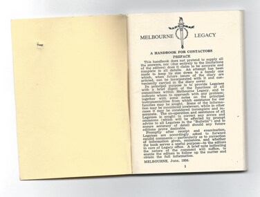 Melbourne Legacy
Booklet, Handbook for Contactors
A handbook is issued to all Legatees to assist them with their work with the legacy widows; eg childrens' education, welfare, accommodation, health. A quick easy guide to services provided by Melbourne Legacy such as bursaries, medical care, financial assistance etc for Legatees use. It was reissued annually for many years prior to keeping this information electronically. Many issues are held at 00305. Chapters of the book include the following, many of which are committees: Administration Anzac Day Observance Comradeship. 'Comradeship is an integral and important part of Legacy. This committee's function is primarily to arrange social and other activities which bring members together so that they become known to each other on an intimate and friendly basis; and so that when a member strikes a problem, he immediately knows with whom he might get into touch to discuss it in then spirit of mutual assistance.' Finance Huntingdale (Golf Club) Intermediate Legacy Liaison Personnel Committee Programme Committee Dealing with the Junior Legacy Committee: Boys' Group Camps and holidays Christmas party Contact Cultural and Library Dental Demonstration Education Employment Firewood Girls' Group Housing and accomodation Legal Longbank (holiday home for widows in need of a rest) Medical Newsletter Older widows Optometrists Pensions Probation Residences Special cases Welfare Appendix A Allowances for school requisites Appendix B Scholarships Appendix C Pensions / War widows pensions / Commonwealth widows pensions / Immediate assistance SCTF Appendix D Repatriation Department Appendix E Commonwealth Social Services Appendix F CWD - Children's Welfare Department Appendix G Hospital and medical benefits for Legacy Widows and their dependants Appendix H AMF Relief Trust Fund Appendix I SCTF - Services Canteen Trust Fund Appendix J Sir Samuel McCaughey Bequest Appendix K Various sources of assistance available (eg clothing, blankets, POW associations, RSL, conveyance allowances.)This booklet assisted legatees locating services available to widows and children from within Legacy or government departments.Cover, cardboard, colour pale yellow, pages paper, colour white. Black print. Corners of cover cut off at an angle.Melbourne Legacy, Legacy symbol, Handbook for Contactors, issued with Melbourne Legacy Diary 1960. regulations, objectives, rules, register -
 Melbourne Legacy
Document - Speech, 'Forty Years On' Foundation Day 1967 address by Past President Brian Armstrong (H30), 1967
In September 1967 Legatee Brian Armstrong gave a speech about the first 40 years of Legacy. He mentions; 'what, in all humility, does our word 'Legacy' conjure up? To each of us, no doubt, something different, according to the the period of our service and our particular interests. To the early ones, many pictures, grave and gay, many voices, two perhaps in particular, both on the brink of a discovery. One, rather triumphant, - 'I've got it, we will call it "Legacy", but we will give instead of take, and look for nothing in return; and two years later, a quiet voice, still with us, thank heaven, "Have you ever through what the dying wish of our cobbers would have been?". This is our link. On the one hand, the still sharp memory of the lost men of Anzac France, Belgium, and the Middle East. One's own private nightmare - the expression in the eyes of the men of one's own Platoon, particularly towards the end, when they were warned for yet another operation. Men who by some miracle had survived twelve and more separate and individual hells between Gallipoli and Villers-Bretonneux and who knew full well that the Hindenberg Line was yet to come. And then we lucky ones were home again . . . Now here it was, the link, the chance to do something of real personal value, something with a real future. We do not speak a great deal of these things, nor would I do so now if I were not sure that everyone of you who wears this small badge has travelled much the same road. " He mentions the Legacy Diary belonging to Frank Meldrum, from 1925, with records on the start of Legacy. It is believed this diary was one of many documents lost in a fire. He mentions the fire destroyed the home and valuable library of Legatee Jimmy Downing. The notation H30 in red pen shows that it was part of the archive project that was trying to capture the history of Legacy. A speech given at a Legacy function that has significant information about the first forty years of Legacy.White foolscap paper with black type x 5 pages of an address by Legatee Armstrong on 26 September 1967.Handwritten H30 in red pen.history, speakers, speech, founding legatee -
 Clunes Museum
Document - SCHOOL OF MINES - CLUNES BRANCH, KEN CLEMMENTS
1889 BALLARAT SCHOOL OF MINES ENJOYED HIGH STATUS IN AUSTRALIA AND OVERSEAS. SEVERAL SMB STUDENTS WERE RESIDENTS OF CLUNES. SCHOOLS OF MINES HAD BEEN ESTABLISHED AT SEVERAL OTHER DISTRICT CENTRES INCLUDING MARYBOROUGH AND CRESWICK, OTHERS WERE TO FOLLOW AT ARARAT, STAWELL AND DAYLESFORD 1890 CLUNES BOROUGH COUNCIL WITH MR JOSEPH BRYANT LEADING, APPROACHED THE BALLARAT SCHOOL OF MINES REQUESTING SUPPORT FOR A BRANCH SCHOOL AT CLUNES OFFERING ELEMENTARY CLASSES WITH SMB STAFF AS LECTURERS SMB COUNCIL AGREED TO STAFF THE SUGGESTED CLASSES. SEVERAL PUBLIC LECTURES WERE ARRANGED AT CLUNES TO HELP CREATE INTEREST IN THE NEW CLUNES BRANCH OF SMB. CLASSES SOMMENCED SOME AT THE CLUNES FREE LIBRARY AND SOME AT THE NEW NORTH CLUNES MINE OFFICE/LABORATORY PER FAVOUR OF JOSEPH BRYANT WHO WAS HONORARY DIRECTOR OF THE BRANCH SCHOOL. 1891 LOWER STUDENT NUMBERS CAUSING CONCERN.. EDUCATION DEPARTMENT REGULATIONS FOR SCHOOLS OF MINES AND TECHNICAL SCHOOLS AND CONFLICTING VIEWS OF GOVERMENTMINISTERS RE SUBJECTS THAT COULD BE TAUGHT , CAUSED DIFFICULTIES. ONE LOCATION FOR ALL CLASSES BECAME THE ANTICIPATED SOLUTION TO MOST PROBLEMS. TITLE CLUNES SCHOOL OF MINES NO 24 APPEARED IN MEDIA NOTICES AND REPORTS WEST PARADE SITE FRONTING SERVICE STREET GRANTED BY CLUNE SBOROUGH COUNCIL TO COUNCIL OF CLUNES SCHOOL OF MINES FOR ERECTION OF BUILDING FOR SCHOOL PURPOSES. BUILDING COMMENCED 1892 NEW BUILDING OPENED IN FEBRUARY. ALL CLASSES CONDUCTED IN NEW BUILDING.SEVERE LIMITATION IN FUNDING FOR TECHNICAL EDUCATION AND IN MOST GOVERNMENT ACTIVITIES WAS EVIDENT NEW REGULATIONS FOR TECHNICAL SCHOOLS ANNOUNCED FOR OPERATION IN 1893, THE RQUIREMENTS FOR FUNDINGS WERE MUCH TOUGHER. 1893 STUDENT NUMBERS STILL VERY DISAPPOINTING. INSPECTORS DENNANT AND SIMPSON VISITED AND ADVISED ON BEST POSSIBLE FUNDING PROCURABLE . CLASSES CEASED AT THE END OF SECOND TERM (JULY) EXCEPT ART CLASSES WHICH COULD COVER DIRECT COSTS FROM STUDENT FEES. 1894 BUILDING LEASED BY BOROUGH COUNCIL TO ANA ..1 GREEN FOLDER WITH HANDWRITTEN NOTE INSIDE WITH SOME QUESTIONS ABOUT THE SCHOOL OF MINES 12/8/2003 .2 262 PAGES THE HISTORY OF THE CLUNES BRANCH OF BALLARAT SCHOOL OF MINES, INDUSTRIES AND SCIENCE IN THE UNIVERSITY OF MELBOURNE 1890 T0 1893 .3 OUTLINE OF THE STORY OF CLUNES BRANCH OF SMB.1 STICKERS ON FRONT: APPENDIX - CLUNES BRANCH OF SMB - CLUNES SCHOOL OF MINES NO. 24 APPENDIXclunes school of mines, ken clemments, 1890-1893 -
City of Moorabbin Historical Society (Operating the Box Cottage Museum)
Newsletter - CMHS Moorabbin Mirror Vol 8 November 2016, Moorabbin Mirror Vol 8 November 2016, 2016
This is Vol. 8 of the Moorabbin Mirror produced by CMHS members Fran & Holger Bader , Valma Sharp November 2016 The Moorabbin Mirror reflects the history and heritage of the former City of Moorabbin — derived from Mooroobin, ‘a resting place’ in the Bunurrung spoken language. In 1994, the City of Moorabbin was integrated into the Cities of Bayside, Glen Eira, Kingston and Monash. Dr.Rosalie Triolo will give a talk for members on Nov. 27th about Local School Teachers in the 1st AIF CMHS AGM Oct 30th. Mrs Valma Sharp retired from Committee and CMHS The Committee proposed a vote of thanks in appreciation of Valma's long , loyal service to CMHS,Box Cottage Museum . Subscriptions for NEW members will be $15 from January 2017. Next AGM will be July 30th 2017 to coincide with the end of the financial year. Due to the cost of ink and postage the CMHS Newsletter Moorabbin Mirror will be available in pdf via email, CMHS website and Victorian Collections website . Local Libraries can assist members to read and or download a copy. GECC and KCC are respectively supporting CMHS/BCM with Community Grants 2016 for utilities and the purchase of laptop, scanner printer copier for the CMHS Original Newsletter Preservation project. The BCM / CMHS joined Glen Eira HS and Brighton Cemetorians for a Heritage Display at GECC Town Hall Gallery Annexe Nov 3rd - 20th. An article about Robert Haddon 1866-1929, architect. Article about Local Artists includes colour photos. The Adelphi Players 'Robinson Crusoe' Dec 3-11 2016, The BCM 'August Rietman Exhibition 2017' is proceeding with guidance from the MAV Roving Curator. Fran Bader, Project Manager, is seeking images, pressed concrete products,information,and recollections. Also any jewellery by Stefanie Rennick (nee Rietman) who was a teacher at Bentleigh Secondary College. CMHS members attended the Opening of the new Bentleigh Railway Station Nov 12th. CMHS now has a mobile phone for incoming enquiries.This is Vol. 8 of the Moorabbin Mirror, Newsletter of CMHS November 2016A4 x 4 paper folded to A5 x 8pp with colour photographsMoorabbin / Mirror / November 2016 Vol 8 moorabbin mirror, bader fran, bader holger, sharp valma, haddon robert, bent tommy, robertson macpherson, reitman august,, brighton cemetery,, glen eira historical society, glen eira city council, -
 Eltham District Historical Society Inc
Photograph, Slab hut, Warrandyte, Warrandyte Mystery Tour, 29 May 1994, 29/05/1994
[article by Bettina Woodburn in EDHS Newsletter No. 97, July 1994:] THE WARRANDYTE MYSTERY TOUR MAY 29TH 1994 - Members of the Eltham Historical Society met at the Old Post Office, now converted into the Warrandyte Historical Museum, for a picnic lunch on the sunny back verandah overlooking the shimmering Yarra River. Interesting photographs and artefacts filled various rooms outlining the history of this area, and told tales of Aboriginal and more recent neighbours of the Eltham Shire. The weather was calm, cloudy mostly with only occasional sunny patches, but it wasn't cold, although the autumnal leaf colours had changed to wintry brown. "All Aboard" and we set off in the Warrandyte Community Bus (with the School Bus sign displayed at the rear) to learn about local places of "Pride and Joy” from Bruce our guide and Tom the driver. Almost directly opposite we entered Whipstick Gully to explore the first of the district's hidden treasures - the Victory, one of the largest of the six or so major mines, past the old quarry now used for abseiling practice. By torchlight we entered the rocky hillside and saw the seams of quartz the miners had followed in their search for gold. Stamping batteries, and there was one in this gully, converted discarded rock into 'road metal'. Warrandyte is proud to be the first declared Goldfield in 1851, and one of the longest surviving, into the 1920s. A pleasant drive across the Bridge and along Bradley's Lane to Norman's Reserve brought us to see another Tunnel at Pound Bend through which the Yarra was diverted to allow about three miles of river-bed to be used for prospecting for alluvial gold. Still on this side of the river we visited the Old Slab Hut in Castles Road. This remnant of miners' housing is preserved because it had been incorporated into a weatherboard house, and saved from the bulldozers - a last minute reprieve, for preservation, by the National Trust. Devastating bush fires have destroyed other old cottages built of wattle and daub, with bark roofs and stone fire-places. The Cairn commemorating the disclosure of Gold Discovery at Warrandyte on June 30th 1851 beside Anderson's Creek Road was our next point of historical interest. We drove on to South Warrandyte and circled back to above the ford on Anderson's Creek to the entrance of the 4th Hill Mine. Again we crept along with our torches, careful of the low roof-rock, and side shafts. At a junction in a large cavity we were able to stand, look up a long air-vent which some 'cavers' climb down, and marvel at, and experience an aspect of a miner's life. Outside we heard the same bird songs, the trills and bell-pealing, saw the same straggly eucalypts, and a silver leafed wattle in flower, native grasses and ferns, and the neat present day houses, often of Warrandyte stone, perhaps veneered only. The day ended pleasantly, seeing more of the Yarra from Everard Drive, and the water rushing out of the Tunnel at Pound Bend, before returning to afternoon tea or coffee at the Museum. A great day for all concerned - many thanks to the Organisers.Colour photographslab hut, warrandyte, "warrandyte miner's cottage" -
 Eltham District Historical Society Inc
Photograph, Pound Bend tunnel, Warrandyte, Warrandyte Mystery Tour, 29 May 1994, 29/05/1994
[article by Bettina Woodburn in EDHS Newsletter No. 97, July 1994:] THE WARRANDYTE MYSTERY TOUR MAY 29TH 1994 - Members of the Eltham Historical Society met at the Old Post Office, now converted into the Warrandyte Historical Museum, for a picnic lunch on the sunny back verandah overlooking the shimmering Yarra River. Interesting photographs and artefacts filled various rooms outlining the history of this area, and told tales of Aboriginal and more recent neighbours of the Eltham Shire. The weather was calm, cloudy mostly with only occasional sunny patches, but it wasn't cold, although the autumnal leaf colours had changed to wintry brown. "All Aboard" and we set off in the Warrandyte Community Bus (with the School Bus sign displayed at the rear) to learn about local places of "Pride and Joy” from Bruce our guide and Tom the driver. Almost directly opposite we entered Whipstick Gully to explore the first of the district's hidden treasures - the Victory, one of the largest of the six or so major mines, past the old quarry now used for abseiling practice. By torchlight we entered the rocky hillside and saw the seams of quartz the miners had followed in their search for gold. Stamping batteries, and there was one in this gully, converted discarded rock into 'road metal'. Warrandyte is proud to be the first declared Goldfield in 1851, and one of the longest surviving, into the 1920s. A pleasant drive across the Bridge and along Bradley's Lane to Norman's Reserve brought us to see another Tunnel at Pound Bend through which the Yarra was diverted to allow about three miles of river-bed to be used for prospecting for alluvial gold. Still on this side of the river we visited the Old Slab Hut in Castles Road. This remnant of miners' housing is preserved because it had been incorporated into a weatherboard house, and saved from the bulldozers - a last minute reprieve, for preservation, by the National Trust. Devastating bush fires have destroyed other old cottages built of wattle and daub, with bark roofs and stone fire-places. The Cairn commemorating the disclosure of Gold Discovery at Warrandyte on June 30th 1851 beside Anderson's Creek Road was our next point of historical interest. We drove on to South Warrandyte and circled back to above the ford on Anderson's Creek to the entrance of the 4th Hill Mine. Again we crept along with our torches, careful of the low roof-rock, and side shafts. At a junction in a large cavity we were able to stand, look up a long air-vent which some 'cavers' climb down, and marvel at, and experience an aspect of a miner's life. Outside we heard the same bird songs, the trills and bell-pealing, saw the same straggly eucalypts, and a silver leafed wattle in flower, native grasses and ferns, and the neat present day houses, often of Warrandyte stone, perhaps veneered only. The day ended pleasantly, seeing more of the Yarra from Everard Drive, and the water rushing out of the Tunnel at Pound Bend, before returning to afternoon tea or coffee at the Museum. A great day for all concerned - many thanks to the Organisers.Two colour photographswarrandyte, activities, pound bend -
 Flagstaff Hill Maritime Museum and Village
Functional object - Urinal, circa 1825
It is probable that the urinal was situated in the forward part of the ship rather than the stern, being one of two placed on either side of the deck and housed immediately adjacent to the doors into for-castle, or crew sleeping quarters. The toilets on maritime vessels were (and still are) called the ‘heads’, after the sanitation arrangements common until the end of the eighteenth century. The name was given to the ‘head’ of the ship, forward of the forecastle and around the beak or bowsprit. These first lavatories were floored with grating or nets so the force of the sea could wash them clean, and they were always used on the lee or non-weather side so the effluent fell directly into the water rather than back on board. The Children wrecking: The barque Children was one of the first vessels to be lost in the Western District the vessel was wrecked to the east of Warrnambool on 14th January 1838. When it ran ashore in hurricane-force winds, 22 passengers and crew were fortunate to escape being battered to death on the rocks. The Children broke up within 20 minutes, sweeping sixteen of those on board to their deaths. After eleven days, the survivors, all of whom were injured, were rescued and taken to Portland. According to Lloyd's Shipping Register 1837-1839, the Children was built in 1825 at Liverpool and operated by owners Gordon & Co, of London. Registration number 123/1837, James Henty then bought her in 1837 as a three-masted barque of 254 tons, with a hull of “part pitch pine, felt sheathed” and “coppered in 1837” at Launceston registered number 6/1837. In 1838 the Children, under her master Captain H. Browne, completed a successful round trip from Launceston to London (carrying wool and whale oil loaded in Portland), returning in late November of that year carrying a general cargo including house bricks used for ballast. On the 11th of January 1839, the Children sailed from Launceston for Adelaide, with 24 passengers, 14 crew, and an awkward mixed cargo, including 1500 sheep, 8 bullocks, 7 horses, and farming implements, and six whaleboats with associated whaling gear. One account states that when the Children were “put out from port she was light and badly ballasted”. The vessel immediately encountered four days of hurricane-force storms, eventually clearing on the early morning of the 14th. However, it was too late to take accurate measurements of the sun or stars to establish their position relative to the coast. The Children collided with a limestone stack at the entrance of Childers Cove, and the seas smashed her into pieces within half an hour. All the cargo and 16 lives were lost including 8 children. The Henty brothers contributed £150 towards a fund for the 22 survivors at a memorial service held in Launceston later that year. It was a major financial setback for James Henty and his brothers, but one from which they recovered. In a submission to the Governor of New South Wales dated 24 March 1840, the Henty’s summarised their work over the previous six years of establishing the Portland settlement stating. “Six stations have been occupied, one at Portland Bay three at the open country about 60 miles inland called ‘Merino Downs’ They have erected two houses at Portland Bay and two others at Merino Downs”.This urinal is significant as part of the vessels original fittings he Children was delivering cargo intended for the Portland Bay settlement of her owners the James Henty brothers The wreck is also significant as one of the first vessels to have been lost in the Western District of Warrnambool. As a result the shipwreck of the Children is registered with the Victorian Heritage Register S116. A lead urinal with a rounded back at the top splash plate with an attached semi-circular receptacle or basin (20cm deep and projecting forward 30cm). At the sides are flanges with bolt holes connecting to a ship's wall. The urinal is drained by a funnel-shaped outlet also made of lead, reducing from a 10cm radius to a joined 5 cm pipe. The urinal was recovered from the wreck of the CHILDREN.Noneflagstaff hill, warrnambool, flagstaff-hill, flagstaff-hill-maritime-museum, shipwreck-coast, shipwreck artefact, the children, lead ship’s plumbing, crew urinal, the ‘heads’, ship plumbing, james henty, portland bay, urinal, ship's urinal -
 Flagstaff Hill Maritime Museum and Village
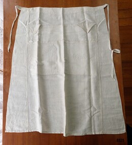
Clothing - Traveller's Apron, Eliza Towns, Circa 1915
This apron is one of several linen and clothing items that were made and belonged to Mrs. Eliza Towns and donated to Flagstaff Hill Maritime Museum and Village. Eliza was born Eliza Gould in 1857 in South Melbourne (Emerald Hill) and in 1879 married Charles Towns. In the early 1880's they moved to Nhill in western Victoria and remained there for the rest of their married life. Charles was a jeweller and later became an accountant and for many years was involved with the Shire Council, the local show committee (A & P Society), the Hospital Committee and the Board of the local newspaper (the Nhill Free Press). They had three children and lived a life that would be regarded as comfortably "middle class". Eliza probably had a treadle sewing machine and would have made many of her own clothes - adding her own handmade embroidered or crocheted decorative trim. In March 1915 Eliza travelled to San Francisco to visit her son, James. She went by train to Melbourne ("a pleasant journey on the up express') and the next day caught the express train to Sydney. She noted in her letters home that a " number of young men were going to Sydney to enlist but they had to stop in the corridors most of the way as there was no room for them to sit down". She spent the night on the train and arrived in Sydney the next morning and on the following day she boarded the R.M.S. "Moana" (a steamer which took about twenty-four days to reach San Francisco). She returned from Vancouver about five months later on board the "Manuka". It is very likely Eliza took this "Travelling Apron" with her on her travels. Eliza was travelling by herself and had no one to help her with her dress or her hair. "Travelling Aprons" (also known as Toilet Aprons or Tourist Aprons) were designed with different sized pockets for holding a lady's toiletries - hairbrush, hair pins, comb and sometimes even soap and a powder puff. This allowed the owner, when travelling and getting dressed in small places such as an overnight train compartment or a ship's cabin, to have all her requirements at hand without needing to search for them or have them roll onto the floor. Some of the pockets are finished with buttoned flaps to keep the items in place and when not in use, the apron could be hung up or rolled up and put away. Articles about the "Traveller's Apron" appeared in numerous Women's columns in Australian newspapers in the early 20th century - often with instructions and sometimes a pattern. In the "Age" on Sat 5th October 1907 in a column titled "Feminine Facts and Fancies" the author wrote "No man can appreciate the difficulties of dressing in a "wobbly" train or trying to do one's hair while a ship is weathering a storm". A year earlier (Saturday 24th March 1906) in the same column, the author wrote "... you have to spend nights in a train... forever struggling to dress yourself in a wretched little lavatory. You know how your hairpins and combs jump all over the place ... a train is always at its liveliest when you're trying to do your hair. My travelling apron saved me many a rage."This item is an example of the needlework skills of women in the early 20th century - combining machine stitching with hand embroidery to personalise and embellish a practical domestic object. It is also an excellent (and rare) example of an early 20th century innovation that helped solve the difficulties of privacy and convenience that many women experienced at a time when travel was becoming more accessible to them. A half apron, made of ivory linen with two waist ties and seven pockets. Along the top are two smaller pockets with triangular, buttoned flaps labelled "Hairpins" and "Nailbrush" and one larger unlabelled pocket. Underneath are two larger pockets labelled "Brush & Comb" and "Work" and two unlabelled narrow pockets. The seams are machine stitched and the pockets are outlined with hand embroidered feather stitch. The labels on the pockets are embroidered in stem stitch."Hairpins" / "Nailbrush" / "Brush and Comb" / "Work"flagstaff hill maritime museum and village, nhill, eliza towns, apron, travelling apron, tourist apron, textiles, toilet apron, sewing, embroidery, travel, warrnambool, great ocean road, trains, ships, moana, manuka, feather stitch, stem stitch, fashion, handmade, clothing, charles towns, needlework -
 Melton City Libraries
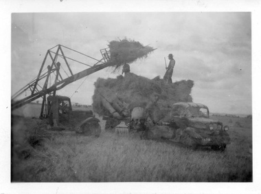
Photograph, Harvesting, 1950
1950 decade HAY FORK - A local invention. Bill and Arthur Gillespie and Bon Barrie In the early 1950’s Bill Gillespie of Bulmans Lane had been experimenting in developing a machine to improve the collection of hay sheaves at harvesting and stack building time. The ripened crop was cut by a reaper and binder which bundled the storks into sheaves tied with binder twine. The reaper and binder was towed by a tractor by the mid 1940s previously teams of draught horses were used to pull the reaper and binder. A photograph taken at the Barrie farm shows three binders the first being towed with a tractor and the others with horse teams. Two workmen were needed to operate the binder when cutting a crop. The sheaves collected on the binder and released onto the ground and were scattered across the paddocks. Using a conventional two pronged pitch fork the harvest hands collected the sheaves and placed each one cut edge on the ground in an upright position and layered with about 15 sheaves into an apex shape to form was is known as a stook. The shape of the stook allowed for drying and draining of water if rain had occurred. Prior to the invention of the mechanical hayfork this was a laborious task requiring each sheaf to be pitched onto a tray truck and moved to the location of the haystack. The mechanised HAYFORK was operated by one person on tractor greatly reducing the need for gangs of labourers. At harvest time farmers had relied on itinerant teams of workers descending on the district looking for work. The three Barrie brothers on their adjoining farms combined forces to cut their crop at its optimum time while the weather was in their favour. Up to many 20 workers at times formed a team in earlier times. Agricultural university students were also keen to gain practical experience in the field. Each of the brothers had a particular skill, and Tom Barrie was the expert on stack building. The district haystacks had a distinctive shape and could be recognised by their builder. Bill Gillespie’s first operational HAY FORK consisted of a large 13 pronged fork situated forward of the truck cabin. It was attached with iron girders and mounted on the rear of the cabin to the tray of his British Bedford truck. It was constructed in metal and iron and welded in the farmers work sheds. The mechanism was raised and lowered by the driver scooping along the ground to pick up a complete stook to raise high enough to deposit all the sheaves in one stook onto the stack or truck tray. The fork section was released by a rope and operated by the driver in the cabin. This model was trialled on the Barrie farm at Ferris Lane. It proved to be very successful and the Barrie/ Gillespie brothers went on to develop a HAYFORK which attached to a tractor and was operated with a series of levers and was raised and lowered hydraulically. It was detached from the tractor when stacking was completed. In its early days farmers travelling along the Western Highway called at the Barrie farm at Ferris Lane to inspect its construction and operation of the invention. It became a widely adopted by farmers throughout the State. It was being used on Wattie Palmer’s farm on Bridge Road Melton South in 1997. Farming in Melton, hay growing and stack building. agriculture, local identities -
 Flagstaff Hill Maritime Museum and Village
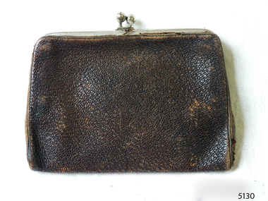
Accessory - Purse, c. 1855
This small purse belonged to David and Alice Ellis, a young couple married in Dublin in 1855. It has been handed down in the Ellis family until it was donated, together with other personal effects, in 2004 by David and Alice’s granddaughter, daughter of David Ellis Junior. On 6th October 1855 newlyweds David and Alice Ellis set sail for Australia in the brand new Schomberg, considered the most perfect clipper ship. She was built as an emigrant ship in Aberdeen and set sail from Liverpool on her maiden voyage, bound for Melbourne, Australia. She was loaded with 430 passengers plus cargo that included iron rails and equipment intended for building the Geelong Railway and a bridge over the Yarra from Melbourne to Hawthorn. On 27th December 1855, only one day from her Melbourne destination, the Schomberg was grounded on a sand-spit on the Victorian coast near Peterborough. The passengers and crew were all safely rescued by a passing small steamer, the SS Queen, which traded between Melbourne and Warrnambool, and taken to Melbourne. The passengers had been told, when leaving the sinking Schomberg, that all they could take with them was a small basket or handbag. A newspaper article later mentioned that one of the things Alice made space for in her basket was her Bible. (It is unclear whether Alice took any possessions with her onto the SS Queen, but a note accompanying the donation of the Bible and basket states that the items were “left on deck and salvaged as Schomberg went down”.) Another steamer was despatched from Melbourne to retrieve the passengers’ luggage from the Schomberg and Alice was reunited with all of her boxes of belongings. Other steamers helped unload the cargo until the change in weather made it too difficult. Although the Schomberg was wrecked there were no lives lost. At that time David was 23 years old (born in Wales, 1832) and his new bride Alice was 26 (born in Dublin, 1829). They had been given letters of introduction to people in Tasmania so they travelled there from Melbourne. However the couple only stayed on that island for about a year before they returned to the Western District of Victoria. David worked for Mr Neil Black as a gardener for a while then, when the land in the area was made available by the Victorian government, David and Alice claimed a selection of land on Noorat Road in the Terang district. They settled there for the remainder of their lives, expanding their property “Allambah” as opportunities arose. A document accompanying the donation lists the names of six children; William, Grace (c. 1859-1946), Thomas (c. 1866 – 1939), David (c. 1962 – 1953), James and Victor. David died on 13th April 1911, aged 79, at their property. Alice passed away the following year, November 1912, aged 83. Alice’s obituary described her as “a very homely, kindly-natured woman, who was highly esteemed by a large circle of friends; and she was also a firm adherent of the Presbyterian Church”. At the time of Alice’s death she left behind three sons and one daughter. Her daughter Grace Ellis was also a very active member of the Terang Presbyterian Church and a member of the PWMU (Presbyterian Women’s Missionary Union). She was also involved in the Red Cross and other charities. Grace passed away in 1946, aged 87. David and Alice Ellis were amongst the very earlies pioneers of the Terang district of Western Victoria. Their donated possessions are a sample of the personal effects of emigrants to Australia. The donated items are a sample of the personal goods carried aboard a significant migrant ship in 1855. They are also significant for their association with the Schomberg. The Schomberg, which is on the Victorian Heritage Register (VHR S612), has great historical significance as a rare example of a large, fast clipper ship on the England to Australia run, carrying emigrants at the time of the Victorian gold rush. She represents the technical advances made to break sailing records between Europe and Australia. Flagstaff Hill’s collection of artefacts from the Schomberg is significant for its association with the shipwreck, The collection is primarily significant because of the relationship between the objects, as together they have a high potential to interpret the story of the Schomberg. It is archaeologically significant as the remains of an international passenger Ship. It is historically significant for representing aspects of Victoria’s shipping history and for its association with the shipwreck and the ship, which was designed to be fastest and most luxurious of its day Purse, leather, rectangular shape with metal frame and catch. Purse was amongst the possessions of David and Alice Ellis, passengers on the Schomberg when wrecked in 1855.schomberg, shipwrecked coast, flagstaff hill, flagstaff hill maritime museum, maritime museum, shipwrecked artefact, warrnambool, shipwreck, purse, leather purse, personal effects, 1855 shipwreck, peterborough shipwreck, ss queen, david ellis, alice ellis, allambah terang, dublin emigrants, terang presbyterian church, western district victoria -
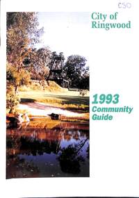 Ringwood and District Historical Society
Book, City of Ringwood, City of Ringwood 1993 Community Guide, 1993
Community information book issued by City of Ringwood for 1993 - covering the facilities and activities of the Ringwood Council and other local organisations and associations. Includes two Ringwood Aquatic Centre bonus entry vouchers valid until June 30th, 1993. Cover photographs: Front - Poppet Head, Ringwood Lake; Back - Opening of North Ringwood Child Care Centre. CONTENTS: (page no.) Message from the Mayor – Cr. Greg Adkins, J.P. 3 Councillors 4 Council & Committee Cycle 5 Council Elections 6 History of Ringwood 7 Chief Executive's Report 8 The Management Team 9 Functional Responsibilities 10 Community Liaison 11 Council Expenditure for 1992/93 12 Rates and Valuations 13 COUNCIL SERVICES Community Services 14 Protecting the Environment 17 Protecting Our Community 19 Town Planning 21 Building 22 Design and Investigation 23 Works 24 Street Index - Electoral Wards 25 Neighbourhood Map 26 and 27 COUNCIL RECREAION AND LEISURE FACILITIES Ringwood Golf Course 29 Aquatic Centre 30 The Ringwood Convention Centre 32 Ringwood Library 34 Ringwood Recreation 35 Parks and Reserves 30 Community Directory 38-50 Community Information Data Bank 51 Aquatic Centre Vouchers 51rinx -
 Ballarat Heritage Services
Photograph - Colour, Clare Gervasoni, University of Melbourne Old Law Building, 2010, 29/09/2010
Melbourne University Old Physics Building (1889) was designed by Reed, Henderson and Smart. It later house the Univesity's Centre for Indigenous Education and a conference centre (2010).Colour photograph of the windows of the Melbourne University Old Physics Building.A plaque on the wall of this building states: In April, 1856 stonemasons woking on this building downed tools, marched to the city and inaugrated a movement which win the Eight Hour Day for building workers in Victoria. The victory became an international landmark in the history of the labour movement. Another plaque reads: This, the original building of the University was built of Tasmanian freestone between 1854 and 1857 to the design of F.M. White, architect. It was for many years the University's administrative centre, library, lecture rooms, and professorial residences. The east and west wings were extended in 1930 to the design of J.S. Gawler. In 1969, the quadrangle was completed by the addition of the southern wing which contains the council chamber, designed by R.E. Featherstone. A third plaque states: These cloisters, commenced in 1853 and extended in 1930 nd 1969 were completed in 1981 through the generosity of the late Edward Stevens, a member of Council from 1926 until 1939. The work was also supported by the Wilson Trust and Sir Wilfred Brookes.university of melbourne, old law building, eight hour day, stonemasons, tasmanian freestone, cloisters, edward stevens, wilson trust, wildred brookes -
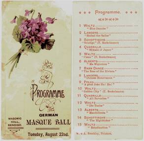 Bendigo Historical Society Inc.
Programme - Programme for German Masque Ball, 1905
Two cardboard parts to a printed programme. On one is a posy of violets and the printing: "Programme German Masque Ball, Tuesday 22nd. The second lists 15 dances. Printed by A. Brookley, Printers. Also are the following two articles from Trove: From the Bendigo Advertiser and the Bendigo Independant, Wed 23 Aug 1905: GERMAN MASQUE BALL. The pleasant plan of fancy masque ball, which for nearly 20 years now has been an annual fixture at this season, is always looked forward to with delight. It is got up by the Bendigo Deutcher Verein, in aid of their free library. The function took place last night in the Masonic Hall and was most enjoyable, and all who took part in it were delighted. The hall was tastefully decorated with flags, flowers and ferns. Bockelmann's Band occupied the stage and discoured sweet music. Many of the items on a long programme were of Mr. Bockelmann's own composition, notably the schottische "Bendigo," the waltz 'Como, 'and the waltz "Golden City." By 9 o'clock there were about 80 couples on the floor. Amongst the merry troupe of dancers were youths and maidens in all sorts and descriptions of gay costumes, including flower girls, Japanese lady, German peasant, lily of the valley, Mercia, Geisha girl, French Vivandiere, red dominos, black dominos, "The Last Rose of Summer," rose, sailor girls, gondolier, Pierot, Charles II., Tipperary boy. Toreador, Romeo, Prince Le Var, huntsman, Indian prince, fireman, barristers. jockeys, cricketers, etc. Many of the Iadies were in evening dress, but wore the masque. The arrangements were admirably carried out by the secretarv. Mr. J. D. Khaland, while it would be difficult to find a better M.C. than Mr. J. Armstrong. The dancing was witnessed by a large number of the public, who were accommodated on a temporary gallery at one end of the hall. A small charge was made for their admission, which helped to swell thelibrary funds. An excellent supper, served in Mr. W. C. Dick's best style, was much enjoyed. Dancing was kept up till about three o'clock, everybody pronouncing the gathering a highly enjoyable one. bendigo history, sandhurst, lutheran german church, penny school -
 Melbourne Tram Museum
Magazine, Metropolitan Transit Authority (MTA), "Met Lines", September 1984 to June 1985
Magazine, published by the Metropolitan Transit Authority of Victoria "Met Lines" (Metlines) - A3 when folded, printed on white gloss paper, with the MTA logo or symbol. Issued under the name of L. A. Strouse as Chairman. Continues from Reg Item 1040 - "Headway News" Major tram and bus items listed. Tramway and bus names only listed, not railway. .1 - Vol 1 No. 1 - September 1984 - 8 pages - 130 years of rail service. Has note about former name, station revitalisation, Met Miles achieved, travel club, Centre page spread of photos of Preston workshop activities, names in Key Associations, repainting of Scrubber 8W, 8, 745, Vic Tramways Bowls Association, Alan Edwards retirement, item on Hawthorn Clothing Workshop (with photo), Munitions bus 301 - Geoff Foster, John Weighman and Daryl Mead and sporting news, - Preston Workshops Soccer team. .2 - Vol 1 No. 2 - 8 pages - Christmas Issue 1984 - Intermodal - Box Hill, Royal Show, A class tram introduced - Driver Don Everard, new tourist guide, Neighbourhood bus revamp in Ringwood, Westona station, Bundoora extension, Transit brass band, Beppie Hedditch - Occupational Welfare Service at Hawthorn, B class trams, sporting news and restored Tacit train. .3 - Vol 1 No. 3, March 1985 - 8 pages - introduction of AVM, bus driver Geoff Neicno, Communications Technician Bruce Smith with MTA Posters or advertisements, Bundoora extension opened, exporting tramway expertise, bus neighboured planning, English on the Job, Met card travel competition, 130 new B class trams and auction sale of Tait Trains. .4 - Vol 1 No. 4 June 1985 - 8 pages - Flagstaff opened, Men at Work band, investigation Officers, library moves to Queen St, first annual report, families on the job - Kimber, Sutton and Luciews, AVM at Nicholson St Engine house. The magazine continues to an A4 version ,see Reg item 1059 and onwards.trams, tramways, mta, preston workshops, hawthorn, buses, sports, box hill, a class, tramway band, welfare, b class, posters, advertisements, metcard, competition, new trams, flagstaff station, nicholson st, tram 8, tram 745, tram 8w -
 Eltham District Historical Society Inc
Photograph, The Weekly Times, Opening of the Heidelberg-Eltham Railway Line, 6 June 1902, 1902
Reproduced from "The Weekly Times", 14th June 1902, page 10. 06 Jun 1902 Cross Reference Photo No.(s): 602, 604 Source: La Trobe Library and National Library, Canberra THE HEIDELBERG TO ELTHAM RAILWAY. OPENING CEREMONY. The opening of the railway line from Heidelberg to Eltham took place on the 6th inst. The special train, containing a large number of members of Parliament, including Mr Trenwith, the Minister for Railways, left Prince's Bridge at half-past eleven, and arrived at Eltham at twenty minutes past twelve. The party was accompanied by Mr Fitzpatrick, Acting Commissioner for Railways; Mr Lockhead, the Traffic Manager; and Mr Norman, Engineer for Existing Lines. On arrival, the visitors were entertained at a banquet in the marquee, of which a photograph is given, erected close to the railway station. Mr E. H. Cameron, M.L.A., the member for the district, occupied the chair, and, seated on his right, was Mr Mason, the Speaker of the Legislative Assembly, and on his left the Minister of Rail-ways. After the banquet His Excellency the Governor-General arrived, and was received and welcomed by Mr Cameron, the local State school children singing the National Anthem. The Governor-General, in declaring the line open, said that he felt highly honored at being asked to perform the opening ceremony, and he trusted that the railway would be a source of great convenience to the inhabitants of the district. He was sorry to say that this would be the last opportunity he would have of seeing them. It cost him a great deal to leave them. (Hear, hear.) He had a great many friends amongst all sections of the community, and he could hardly bear to trust himself to speak about leaving them. (Hear, hear.) He was sorry Lady Hopetoun was on the high seas, and unable to accompany him that day. Mr Cameron thanked his Excellency for performing the opening ceremony, and hoped the trip home would have the effect of restoring His Excellency to good health again. In replying. Lord Hopetoun thanked them sincerely for the cordial vote of thanks. He hoped Providence would shower her blessings over them, and that they would have a series of good seasons. He would always keep a warm corner in his heart for the people of Victoria. (Loud cheers.) THE COUNTRY. In our illustrations, views are given of a couple of sections of the new line, and glimpses of the surrounding country are shown. The line is eight miles in length, and cost £51,000 in construction. Eltham, which is the terminus, possesses many of the features that go to make a favorite holiday resort. It is a quiet picturesque little hamlet, snugly ensconced on the slope of one of many sombre-tinted hills by which it is sur-rounded. Even when viewed under ad-verse conditions one could not fail to be-impressed with the natural, rugged beauty of the place. It is situated about sixteen miles from Melbourne, and the line takes a circuitous course through a continuation of pretty undulating country. At intervals on the slopes of the surrounding green-mantled hills, patches of brown, freshly tilled soil indicate that for all its serene reposeful-ness Eltham possesses its phases of industrial life as well. Looking down into this valley from the main road which skirts the slope of a hill, distant something less than a quarter of a mile from the railway station is one of the prettiest pieces of scenery in the district. Verdure-clad hills ascend on all sides, whilst beneath stretches a broad expanse of carpet-like green sward, dotted here and there with picturesque homesteads, each with its patches of tilled soil. In the township itself the dwelling-houses are comparatively few, the larger portion of the inhabitants residing in the scattered homesteads. Eltham is as yet only in its youth, but energetic and un-tiring public men can effect wonders in a community's prosperity, and Eltham, whatever other real or imaginary advantages it may lay claim to, certainly possesses this one. The railway is the result of their endeavor. 1902 'THE HEIDELBERG TO ELTHAM RAILWAY.', Weekly Times (Melbourne, Vic. : 1869 - 1954), 14 June, p. 14. , viewed 26 Sep 2018, http://nla.gov.au/nla.news-article221230719This photo forms part of a collection of photographs gathered by the Shire of Eltham for their centenary project book,"Pioneers and Painters: 100 years of the Shire of Eltham" by Alan Marshall (1971). The collection of over 500 images is held in partnership between Eltham District Historical Society and Yarra Plenty Regional Library (Eltham Library) and is now formally known as the 'The Shire of Eltham Pioneers Photograph Collection.' It is significant in being the first community sourced collection representing the places and people of the Shire's first one hundred years.Digital image 35mm B&W negativesepp, shire of eltham pioneers photograph collection, eltham, heidelberg-eltham railway extension -
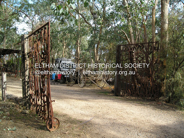 Eltham District Historical Society Inc
Photograph, Fay Bridge, Clifton Pugh's Artists' Colony, Dunmoochin, Barreenong Road, Cottles Bridge, 14 May 2016
Following military service in the second world war, Clifton Pugh studied under artist Sir William Dargie at the National Gallery School in Melbourne as well as Justus Jorgensen, founder of Montsalvat. For a while he lived on the dole but also worked packing eggs for the Belot family saving sufficient to purchase six acres (2.4 ha) of land at Barreenong Road, Cottles Bridge. He accumulated more land and persuaded several other artists and friends to buy land nearby, resulting in a property of approximately 200 acres, stablishing it as one of the first artistic communes in Australia alongside Montsalvat in Eltham. It was around 1951 that Pugh felt he had '"done moochin' around" and so the name of the property evolved. He bought timber from Alistair Knox to build his house on the crest of a hill. Inspired by local goldminer's huts, it was a one room wattle-and-daub structure with dirt floor. Over the years it expanded with thick adobe walls made from local clay, high ceilings and stone floors. All materials other than the local earth were sourced from second hand materials, most found at wreckers' yards. Artists from across the nation were drawn to Dunmoochin, with several setting up houses and shacks on the property, maintaining their independence but sharing their artistic zeal. Artists who worked or resided at Dunmoochin included Mirka Mora, John Perceval, Albert Tucker, Fred Williams, Charles Blackman, Arthur Boyd and John Olsen. In 2002, Pugh's house along with its treasure trove of art and a library of some 20,000 books was destroyed by fire. Traces of Pugh's home remain with the presence of the Victorian doorframe archway with leadlight of intricate design, procured from a demolished Melbourne mansion; and two bronze life-sized female statues created by Pugh and cast by Matcham Skipper. In place of Pugh's house rose two double-storey mud-brick artists' studios topped with corrugated iron rooves curved like the wings of a bird with accommodation for seven. The original studios, gallery and other buildings survived the fire.fay bridge collection, 2016-05-14, art gallery, barreenong road, clifton pugh, cottles bridge, dunmoochin, maurice hurry -
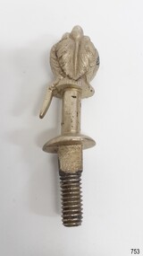 Flagstaff Hill Maritime Museum and Village
Decorative object - Buggy Fitting, Circa 1855
This ornate fitting for a horse-drawn vehicle was amongst the items recovered from the Schomberg over one hundred years after it was wrecked. ABOUT THE SCHOMBERG (October 6 to December 27, 1855)- When the ship Schomberg was launched in 1855, she was considered the most perfect clipper ship ever to be built. James Baine’s Black Ball Line had commissioned her for their fleet of passenger liners. The Aberdeen builders designed her to sail faster than the clippers designed the three-masted wooden clipper ship to be fast. The timber used for the diagonal planking was British oak with layers of Scottish larch. This luxury emigrant vessel was designed for superior comfort. She had ventilation ducts to provide air to the lower decks and a dining saloon, smoking room, library and bathrooms for the first-class passengers. The master for Schomberg’s maiden voyage was Captain ‘Bully’ Forbes. He drunkenly predicted at her launch that he would make the journey between Liverpool and Melbourne in 60 days. Schomberg departed Liverpool on 6 October 1855 with 430 passengers and 3000 tons of cargo including iron rails and equipment intended the build the Geelong Railway and a bridge over the Yarra from Melbourne to Hawthorn. The poor winds slowed Schomberg’s sail across the equator. She was 78 days out of Liverpool when she ran aground on a sand spit near Peterborough, Victoria, on 27 December; the sand spit and currents were not marked on Forbes’s map. The ship’s Chief Officer spotted the coastal steamer SS Queen at dawn and sent a signal. The master of the SS Queen approached the stranded vessel and all of Schomberg’s passengers safely disembarked. In 1975, 120 years after the Schomberg was wrecked, divers from Flagstaff Hill found an ornate communion set at the wreck site along with many other artefacts. In 1978 a diamond ring was discovered under the concretion in the lid of the communion set, which is currently on display. Former Director of Flagstaff Hill, Peter Ronald, had salvaged most of the artefacts from the wreck. The Schomberg has historical significance as one of the first luxurious ships built to bring emigrants to Australia to cash in on the gold rush era. And is included on the Victorian Heritage Register (VHR S612). The collection of Schomberg artefacts held at Flagstaff Hill Museum is primarily significant because of the relationship between these recovered items having a high potential to interpret the story of the Schomberg and its foundering during a storm. The shipwreck is of additional historically significance for representing aspects of Victoria’s shipping history and for its association with the first passenger ship, which was designed not only to be the fastest and most luxurious of its day but foundered on its maiden voyage to Australia.Ornate buggy or coach fitting with feather plumes on top, and a screw thread on the bottom. Silver plated,.warrnambool, flagstaff-hill, flagstaff-hill-maritime-museum, shipwreck-coast, flagstaff-hill-maritime-village, schomberg, shipwrecked-artefact, clipper ship, black ball line, 1855 shipwreck, aberdeen clipper ship, captain forbes, peterborough shipwreck, ss queen, artifact, ornate fitting, buggy fitting -
 Flagstaff Hill Maritime Museum and Village
Functional object - Tap, Ca. 1855
The brass tap was recovered from the wreck of the Schomberg sailing ship. It is severed at the pipe end before the position where the join would have been. This could have happened after the shipwreck or at the time of salvage. ABOUT THE SCHOMBERG (October 6 to December 27, 1855)- When the ship Schomberg was launched in 1855, she was considered the most perfect clipper ship ever to be built. James Baine’s Black Ball Line had commissioned her for their fleet of passenger liners. The Aberdeen builders designed her to sail faster than the clippers designed the three-masted wooden clipper ship to be fast. The timber used for the diagonal planking was British oak with layers of Scottish larch. This luxury emigrant vessel was designed for superior comfort. She had ventilation ducts to provide air to the lower decks and a dining saloon, smoking room, library and bathrooms for the first-class passengers. The master for Schomberg’s maiden voyage was Captain ‘Bully’ Forbes. He drunkenly predicted at her launch that he would make the journey between Liverpool and Melbourne in 60 days. Schomberg departed Liverpool on 6 October 1855 with 430 passengers and 3000 tons of cargo including iron rails and equipment intended the build the Geelong Railway and a bridge over the Yarra from Melbourne to Hawthorn. The poor winds slowed Schomberg’s sail across the equator. She was 78 days out of Liverpool when she ran aground on a sand spit near Peterborough, Victoria, on 27 December; the sand spit and currents were not marked on Forbes’s map. The ship’s Chief Officer spotted the coastal steamer SS Queen at dawn and sent a signal. The master of the SS Queen approached the stranded vessel and all of Schomberg’s passengers safely disembarked. In 1975, 120 years after the Schomberg was wrecked, divers from Flagstaff Hill found an ornate communion set at the wreck site along with many other artefacts. In 1978 a diamond ring was discovered under the concretion in the lid of the communion set, which is currently on display. Former Director of Flagstaff Hill, Peter Ronald, had salvaged most of the artefacts from the wreck. This tap is significant as an example of an item in common use in the mid-19th century. The Schomberg collection as a whole is of historical and archaeological significance at a State level. Flagstaff Hill’s collection of artefacts from the Schomberg is also significant for its association with the Victorian Heritage Registered shipwreck (VHR S 612). The collection is of prime significance because of the relationship between the objects salvaged, as together they help us to interpret the story of the Schomberg. The collection as a whole is historically significant for representing aspects of Victoria's maritime history and its potential to interpret social and historical themes. Brass tap, flat horizontal handle, horn-shaped finish above the spout. The fixture has been severed at the pipe connection end. The surface has since been polished. There is a hole in the side of the pipe near the vertical fitting. It was recovered from the wreck of the Schomberg.flagstaff hill, warrnambool, flagstaff hill maritime museum, maritime museum, shipwreck coast, flagstaff hill maritime village, great ocean road, shipwreck artefact, schomberg, brass tap, plumbing fitting, water tap, tap