Showing 74069 items
matching white
-
 Eltham District Historical Society Inc
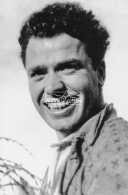
Photograph, Maurie Fabbro at age 20 at Fabbro's farm in Bell Street, Eltham, 1940, 1940
The site of the Fabbro farm (Diamond Creek side land) is now called Barrack Bushlands. It is doubtful that Fabbro's farm holding was ever called Barrak Park, This title is fairly recent after the Shire of Eltham purchased the land, including the last section in 1993/94. About this time the area on the west side of Falkiner Street was purchased by a private developer and developed as housing. The area in Bell Street opposite the Eltham High School was purchased by the State Government is recent years and is called Fabbro Fields. The Fabbro Family operated their farm in Bell Street, Eltham. Maurice Joseph Fabbro (Mario) was born 19 January 1920 and passed away 19 November 20091 black and white photographfabbro's farm, maurice fabbro -
 Eltham District Historical Society Inc
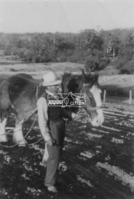
Photograph, Guildo Fabbro, Falkiner Street, Eltham with Clydesdale horse
Guildo Fabbro, Falkiner Street, Eltham with Clydesdale horse with harness in field. The site of the Fabbro farm (Diamond Creek side land) is now called Barrack Bushlands. It is doubtful that Fabbro's farm holding was ever called Barrak Park, This title is fairly recent after the Shire of Eltham purchased the land, including the last section in 1993/94. About this time the area on the west side of Falkiner Street was purchased by a private developer and developed as housing. The area in Bell Street opposite the Eltham High School was purchased by the State Government is recent years and is called Fabbro Fields. The Fabbro Family operated their farm in Bell Street, Eltham. 1 black and white photographfabbro's farm, guido fabbro, bell street, clydesdale horse -
 Eltham District Historical Society Inc
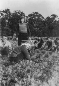
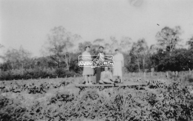
Photograph, At Bell Street; from left: Maurie Fabbro, Myra Skipper, Unknown, Arthur Munday, Ian Robertson. Helen Comprione in front
At Bell Street, Fabbro Farm, Eltham; from left: Maurie Fabbro, Myra Skipper, Unknown, Arthur Munday, Ian Robertson. Helen Comprione in front - probably helping to pick a crop. The site of the Fabbro farm (Diamond Creek side land) is now called Barrack Bushlands. It is doubtful that Fabbro's farm holding was ever called Barrak Park, This title is fairly recent after the Shire of Eltham purchased the land, including the last section in 1993/94. About this time the area on the west side of Falkiner Street was purchased by a private developer and developed as housing. The area in Bell Street opposite the Eltham High School was purchased by the State Government is recent years and is called Fabbro Fields. The Fabbro Family operated their farm in Bell Street, Eltham. 1 black and white photographfabbro's farm, guido fabbro, bell street, arhur munday, eltham, helen comprione, ian robertson, maurice fabbro, myra skipper, picking, farming -
 Eltham District Historical Society Inc
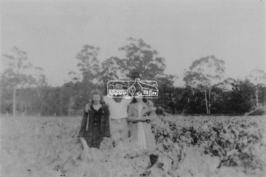
Photograph, From left: Unknown, Mario Fabbro and possibly Helen Skipper, Bell Street, Eltham
At Bell Street, Fabbro Farm, Eltham; From left: Unknown, Mario Fabbro and possibly Helen Skipper, standing in the middle of a vegetable crop. The site of the Fabbro farm (Diamond Creek side land) is now called Barrack Bushlands. It is doubtful that Fabbro's farm holding was ever called Barrak Park, This title is fairly recent after the Shire of Eltham purchased the land, including the last section in 1993/94. About this time the area on the west side of Falkiner Street was purchased by a private developer and developed as housing. The area in Bell Street opposite the Eltham High School was purchased by the State Government is recent years and is called Fabbro Fields. The Fabbro Family operated their farm in Bell Street, Eltham. 1 black and white photographfabbro's farm, bell street, eltham, maurice fabbro, farming, helen skipper, vegetables -
 Eltham District Historical Society Inc
Photograph, At Bell Street, Eltham; from left: Helen Skipper, Matcham Skipper, Sonia Skipper and possibly Myra Skipper
At Bell Street, Fabbro Farm, Eltham; From left: Helen Skipper, Matcham Skipper, Sonia Skipper and possibly Myra Skipper, standing in the middle of a vegetable crop. The site of the Fabbro farm (Diamond Creek side land) is now called Barrack Bushlands. It is doubtful that Fabbro's farm holding was ever called Barrak Park, This title is fairly recent after the Shire of Eltham purchased the land, including the last section in 1993/94. About this time the area on the west side of Falkiner Street was purchased by a private developer and developed as housing. The area in Bell Street opposite the Eltham High School was purchased by the State Government is recent years and is called Fabbro Fields. The Fabbro Family operated their farm in Bell Street, Eltham. 1 black and white photographfabbro's farm, bell street, eltham, farming, helen skipper, vegetables, matchcam skipper, myra skipper, sonia skipper -
 Eltham District Historical Society Inc
Photograph, The Robins, Warrandyte
The Robins (1913). 13 Kangaroo Ground-Warrandyte Road, North Warrandyte built of reinforced concrete for artist Theodore Penleigh Boyd, father of Robin Boyd. The Robins - Penleigh Boyd House Victorian Heritage Database (Shire of Nillumbik) https://vhd.heritagecouncil.vic.gov.au/places/63466Copy of black and white photographthe robins, houses, kangaroo ground-warrandyte road, north warrandyte, penleigh boyd, robin boyd -
 Eltham District Historical Society Inc
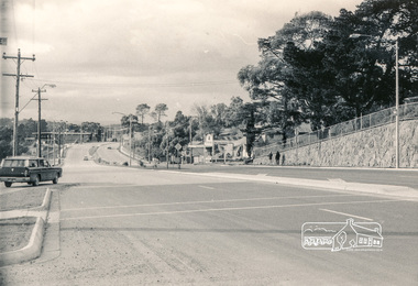
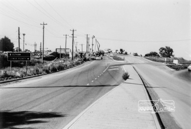
Photograph, Intersection of Main Road and Bridge Street, 1971, 1971
Black and white photograph (2)Shire of Elthambridge street, main road, eltham -
 Eltham District Historical Society Inc
Photograph, Bend of Islands, c.1926
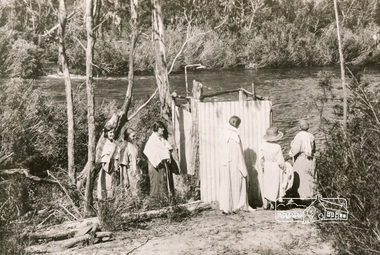
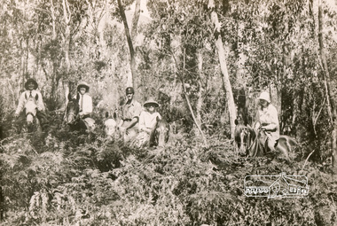
Bend of Islands is named after a group of small islands at a bend of the Yarra River near Watsons Creek. It is located near the town of Kangaroo Ground. The locationn was a long time favourite spot for locals and visitors to fish and swim in the river. This is one of a series of four photographs that depict a mainly young group of people recreating in the area, particularly enjoying horse riding. Possibly weekend campers. Photos taken about 1926-1928. In 1938 "The Argus" advertised weekend cabins at the Bend of Islands estate 5-are Yarra Yarra frontage in the Christmas Hills Gorge ideal for weekend cabins. "Bathing, fishing, canoeing, shooting may be enjoyed in ideal surroundings". This photo seems to be depicitng women waiting to use the shower near the river, or are they going swimming?Black and white photograph (reproduction)Bend of Islands, c.1926 bend of islands, camping, shower block, yarra river, swimming -
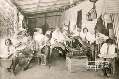 Eltham District Historical Society Inc
Photograph, Bend of Islands, c.1926
Bend of Islands is named after a group of small islands at a bend of the Yarra River near Watsons Creek. It is located near the town of Kangaroo Ground. The locationn was a long time favourite spot for locals and visitors to fish and swim in the river. This is one of a series of four photographs that depict a mainly young group of people recreating in the area, particularly enjoying horse riding. Possibly weekend campers. Photos taken about 1926-1928. In 1938 "The Argus" advertised weekend cabins at the Bend of Islands estate 5-are Yarra Yarra frontage in the Christmas Hills Gorge ideal for weekend cabins. "Bathing, fishing, canoeing, shooting may be enjoyed in ideal surroundings". Was this a church group? This photo depicts individuals "resting" on a verandah undertaking various solo activities including listening to their gramophone.Black and white photograph (reproduction)Bend of Islands, c.1926 bend of islands, camping, recreation, gramophone, group, campers -
 Eltham District Historical Society Inc
Photograph, Bend of Islands, c.1928
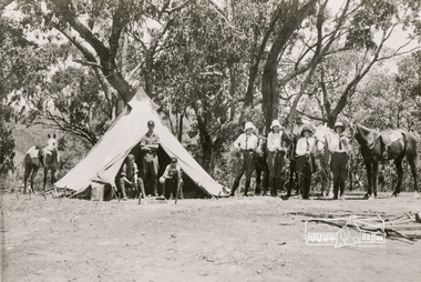
Bend of Islands is named after a group of small islands at a bend of the Yarra River near Watsons Creek. It is located near the town of Kangaroo Ground. The locationn was a long time favourite spot for locals and visitors to fish and swim in the river. This is one of a series of four photographs that depict a mainly young group of people recreating in the area, particularly enjoying horse riding. Possibly weekend campers. Photos taken about 1926-1928. In 1938 "The Argus" advertised weekend cabins at the Bend of Islands estate 5-are Yarra Yarra frontage in the Christmas Hills Gorge ideal for weekend cabins. "Bathing, fishing, canoeing, shooting may be enjoyed in ideal surroundings". Black and white photograph (reproduction)Bend of Islands, c.1928 bend of islands, horse riding, camping, tent -
 Eltham District Historical Society Inc
Photograph, Bend of Islands
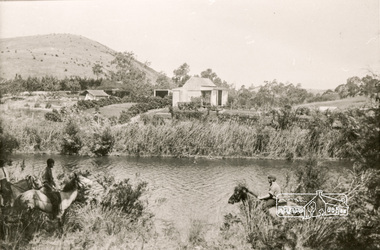
Bend of Islands is named after a group of small islands at a bend of the Yarra River near Watsons Creek. It is located near the town of Kangaroo Ground. The locationn was a long time favourite spot for locals and visitors to fish and swim in the river. This is one of a series of four photographs that depict a mainly young group of people recreating in the area, particularly enjoying horse riding. Possibly weekend campers. Photos taken about 1926-1928. In 1938 "The Argus" advertised weekend cabins at the Bend of Islands estate 5-are Yarra Yarra frontage in the Christmas Hills Gorge ideal for weekend cabins. "Bathing, fishing, canoeing, shooting may be enjoyed in ideal surroundings". Black and white photograph (reproduction)Bend of Islands bend of islands, camping, tent, horse riding -
 Eltham District Historical Society Inc
Photograph, Near Wonga Park Reserve
Black and white photograph (reproduction)Near Wonga Park Reserve wonga park -
 Eltham District Historical Society Inc
Photograph, Research Hotel, c.1910, 1910c
Black and white photograph postcardOriginally inscribed Kangaroo Ground hotel but crossed out and replaced with Research Hotel 1910 From Mr T. Scarse c/o Mrs T.M. jones "Coolibah" Cherry Tree Rd Panton Hill M59 -
 Eltham District Historical Society Inc
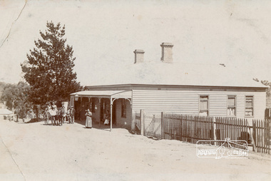
Photograph, Mrs Henry Hill (nee Georgina Reynolds of Research) and others outside the old Hill residence in Bridge Street, Eltham
Early settlers of Eltham Black and white photograph postcardMrs Henry Hill (nee Georgina Reynolds of Research), mother of John Ernest Hill. Identity of others not known to Mrs A.E. Hill , who states 'photo was taken outside the old Hill residence, Bridge St, (south side between Susan and Bolton Streets). Demolished many years ago - 26.7.65 Also stamped - Shire of Elthamhouses, mrs henry hill, bridge street, georgina hill (nee reynolds), hill family, hill family home, john ernest hill -
 Eltham District Historical Society Inc
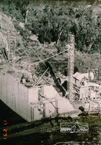
Photograph, Maroondah Dam under construction
Copy of black and white photographmaroondah dam -
 Eltham District Historical Society Inc
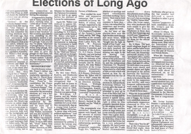
Photocopy of newsclipping, Elections of long ago
Article in unknown newspaper of a reprint of an article: Elections of Long Ago, in Nhill Free Press, 1938. The article discusses William Hall Irvine's election In 1894 when he stood for the rural Legislative Assembly seat of Lowan. Irvine achieved a surprise victory .... Mr Irvine became a Premier of Victoria and Chief Justice and lived the later part of his life at Killeavey, Eltham.A4 black and white photocopysir william irvine -
 Eltham District Historical Society Inc
Photograph, Grant's Cottage, cnr. Main Road and Dalton Street, Eltham
Showing front and side views of former cottage (Grant's house) on cnr Main Road and Dalton Street, Eltham now the site of present-day Eltham Clinic at 700 Main RoadTwo black and white photographshouses, main road, dalton street, grant house -
 Eltham District Historical Society Inc
Photograph, Bridge over the Diamond Creek, Greensborough Road, Eltham, c.1885
Original (1874) bridge in Bridge Street, Eltham looking east over the Diamond Creek towards Maria Street (Main Road) at Little Eltham. In the distance to the right on Maria Street is the Methodist Church (1881), now Uniting Church, and the adjacent Commercial Bank of Australia branch building (1878). Part of a slide show presentation "Bridges & Waterways of the Shire" by Russell Yeoman to the 13 September 1989 Society meeting. The presentation included slides of historic photos from the Shire of Eltham Pioneers collections as well as several recent views.Photo of original 1875 timber and gravel surface bridge over the Diamon Creek in Bridge Street with views of orchards representative of the farming lands as well as the development along the northern end of Maria Street.Black and white photograph copybridge street, bridge street bridge, cba bank, diamond creek (creek), eltham, little eltham, main road, maria street, methodist church, uniting church -
 Eltham District Historical Society Inc
Photograph, Sherbourne Road bridge construction works over railway line, Montmorency, c.1971, 1971c
Black and white photograph printeltham, sherbourne road, railway bridge, construction, montmorency -
 Eltham District Historical Society Inc
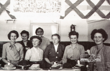
Photograph, Cake Stall at Eltham Fair, 1940s
Most likely the Eltham Springtime Fair run by the Eltham Methodist Ladies Guild and held in the Methodist HallReproduction of black and white photographeltham fair, festivals, eltham, nation, squire, boyd, edwards, carroll, battye, brown -
 Eltham District Historical Society Inc
Photograph, The Marshall family
Black and white photograph (copy)pioneers and painters, marshall -
 Eltham District Historical Society Inc
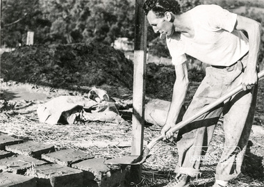
Photograph, Making mud bricks, 1970c
Reproduced on p110 of 'Pioneers & Painters' Individual identified as Tony Jackson. See also SEPP_0789Black and white photograph printpioneers and painters, mudbrick, sepp, tony jackson -
 Eltham District Historical Society Inc
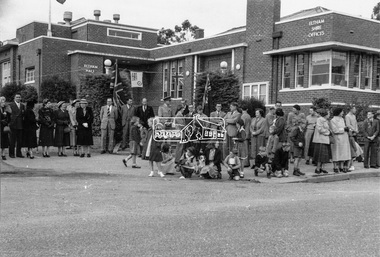
Photograph, Peter Bassett-Smith, Queen Elizabeth II Coronation celebrations and parade, Eltham, Jun 1953
Three black and white photographsalf davis, anz bank, army, arthur street, bert bredle, ceremonies, civic functions, coronation, councillors, cr e.p. harmer, cr f.v. squire, cr frederick e. griffith, cr stanley s. addison, dave lyon house, eltham hall, eltham lower park, eltham shire office, eltham village, eltham, frank davis mhr, guard of honour, main road, mr c.g. seear, mrs alf davis, mrs arthur bird, mrs e.p. harmer, mrs f.e. griffith, mrs frank davis, mrs ham, mrs s.s. addison, mrs squire, parade, queen elizabeth ii coronation, r.j. (dick) ham, shopping centre -
 Eltham District Historical Society Inc
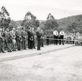
Photograph, Opening Warrandyte Bride, 8 Dec 1955
Built at a cost of £75,000 the five-span reinforced concrete bridge replaced the oldest bridge across the Yarra river, linking the Shire of Doncaster-Templestowe on the south bank with Eltham on the north. The bridge was opened by Mr. G. Reid, M.L.A.Three black and white photographsbridges, warrandyte, yarra river, councillors, ceremonies, stanley addison -
 Victoria Police Museum
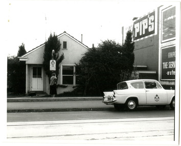
Police Stations (Ascot Vale)
Ascot Vale is an inner suburb 6 km north-west of Melbourne, Victoria, Australia in the local government area of the City of Moonee Valley. Ascot Vale police station was opened on 31 October 1887 in the Melbourne Police District. From 1900-1905 it was located at 54 Parade, Ascot Vale; from 1910-1925 at 71 St Leonards Road; from 1930-1953 at 37 St Leonards Road. In 1953 it was relocated to government owned premises at 111 Union Road until the police station closed on 1st May 1970 and the Sub-district was divided between Flemington and Moonee Ponds police stations. The former police station was used by the Crime Car Squad until about 1987 when the premises were damaged by fire. The police station at 37 St Leonards Road was described as a six-roomed brick dwelling with slate and iron roof on land measuring 150' x 50'. There was also a bathroom and W.C., wash-house, office and lock-up with one cell. It was staffed by one second-class sergeant and four foot constables. The purpose-built police station at 111 Union Road included a four-roomed residence with the exterior clad in rough cast Conite and a tile roof. There was also a kitchen, bathroom, laundry and separate garage. 4 black and white photospolice stations; ascot vale police station -
 Streatham and District Historical Society
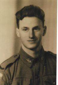
Picture, Ronald Adams
Rectangular Black & white pictureWritten in blue pen on back "Ronald Herbert Adams" -
 Streatham and District Historical Society
Picture, Frederick Chew Snr
Rectangular shape, Black & white. -
 Ringwood and District Historical Society
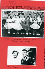
Photograph, Ringwood State School - Square Dance set, 1955. Miss Alday's wedding
Black and white photograph (2)Note attached to photograph. Photograph 1- 1955: Square Dance set, Teacher Miss Alday. Photograph 2- Miss Alday's wedding. -
 Ringwood and District Historical Society
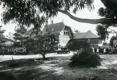
Photograph, Ringwood State School- Building in Ringwood Street. c1912
Black and white photographs (3)Ringwood State School- View of building with students assembled outside. -
 Ringwood and District Historical Society
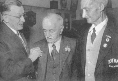
Photograph, Ringwood Bowling Club- Life Member presentation (a). Bowlers on green (b). 1957
Black and white photograph (2)30242(a)- Presentation of Life Member badges at Annual Presentation Night - 1957. J Roberts, J Archbold, A.J Roberts. 30242(b)- Group of bowlers on green, J Archbold in centre.