Showing 32507 items
matching c
-
 Eltham District Historical Society Inc
Photograph, Frank Stokes with his mother Florence (nee West) and children, Dorothy (left), David (centre) and Beryl (right), Stokes Orchard, Nyora Road, Eltham, c.1950, 1950c
Frank's mother Florence was visiting from England at the time. Frank Stokes first traveled to the district by train in 1944 to find land with the intention to establish an orchard. By chance he met Arthur Bird of Bird Orchard (bounded by Pitt Street, Eucalyptus Road and Wattle Grove) and they got talking over their common interest. Arthur put Frank up for the night and pointed out the land, part of Crown Allotment 15, Section 5, Parish of Nillumbik (CA15) somewhat diagonally opposite Bird Orchard. Frank bought the land and for the next two years would travel by train from Melbourne to Eltham every weekend establishing Stokes Orchard and building a home for his family, which they eventually moved into in 1946. In the mid 1970s the Shire of Eltham divided the orchard up into numerous rate-able parcel lots, which became affordable for Frank. As a consequence Stokes Orchard was turned into a housing development by Macquarie Builders and marketed as the Stokes Orchard Estate in two stages; Stage 1 encompassing Scarlet Ash Court, Ironbark Close and Peppermint Grove bounded by Nyora and Eucalyptus roads c.1976 and Stage 2 encompassing Stokes Place, Orchard Way, The Crest and The Lookout bound by Nyora and Diosma roads c.1979. The development of Orchard Way, The Crest and The Lookout did not proceed as planned due to the lack of the sewer along Diosma Road and so many of the proposed lots were incorporated into five-acre parcels instead.Representative of the orchard growing areas of ElthamDigital file only - Digitised by EDHS from a scrapbook (containing commercially printed photos of digital scans) on loan from Beryl Bradbury (nee Stokes), daughter of Frank Stokes.1950, beryl bradbury (nee stokes), beryl bradbury (nee stokes) collection, david stokes, dorothy stokes, eltham, flatbed truck, florence stokes (nee west), frank stokes, nyora road, stokes orchard -
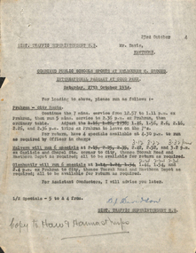 Melbourne Tram Museum
Document - Memorandum, "Combined Public Schools Sports at Melbourne C. Ground & International Pageant at Como Park", 16/10/1934 12:00:00 AM
Memorandum - nine typed sheets (8"x10.5") - titled "Combined Public Schools Sports at Melbourne C. Ground & International Pageant at Como Park - Saturday 27 October, 1934" from DJ Davidson, District Traffic Superintendent S.S. Note paper pinned to front with inscription: "Combined Public Schools Sports at MCG & International Pageant at Como Park Sat 27/10/34" written in red pencil. "Copies to Insps" written in black pencil. Pin removed and discarded. Two newspaper clippings pinned to note paper. 1st titled "Bands at Como Park - Massed Recital To-Day - Finish of Centenary Thousand". "Argus" & "Sat 27/10/34" written in red ink. 2nd titled "Como Park Pageant Abandoned".Numerous notes written in black pencil across memostrams, tramways, instructions, events -
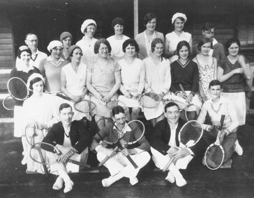 Ringwood and District Historical Society
Photograph, Ringwood Tennis Club (undated). Back row, A. Dwight, T. Wilkins, A. Paris, Mrs. G. Clark, N. Hargraves, B. Covell, E. Lane. Centre, ? Morris, V. Cooper, M. Clark, Miss Calahan, P. Bamford, Rose Whiter, J. Paine, D. Dare, E. Blood. Front, W. Dwight, C. Paris, L. Lane, R. Skerrett, ??
List attached to one photograph reads, "Back row, A. Dwight, T. Wilkins, A. Paris, Mrs. G. Clark, N. Hargraves, B. Covell, E. Lane. Centre, ? Morris, V. Cooper, M. Clark, Miss Calahan, P. Bamford, Rose Whiter, J. Paine, D. Dare, E. Blood. Front, W. Dwight, C. Paris, L. Lane, R. Skerrett, ??" -
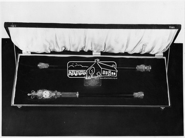 Eltham District Historical Society Inc
Photograph, Black Rod of Victoria Parliament made for Silver & Electroplate Ware Mfrs. Assoc. by Harold C. Hutchinson of Eltham in 1953
In 1951 Victoria commemorated 100 years of the Victorian Parliament. A protective lined keepsake box contains a black rod (in two parts) with a small plaque: "Presented by [the] silver and electroplate ware Manufacturers Association. Made by Harold C. Hutchinson, Eltham. It was first used in 1954. Black Rod is best known for their part in the ceremonies surrounding the State Opening of Parliament and the Speech from the throne. They summon the Commons to attend the speech and lead them to the Lords. As part of the ritual, the doors to the chamber of the House of Commons are slammed in the approaching Black Rod's face. This is to symbolise the Commons' independence of the Sovereign. Black Rod then strikes the door three times with the staff, and is then admitted and issues the summons of the monarch to attend. - Wikipedia This photo forms part of a collection of photographs gathered by the Shire of Eltham for their centenary project book,"Pioneers and Painters: 100 years of the Shire of Eltham" by Alan Marshall (1971). The collection of over 500 images is held in partnership between Eltham District Historical Society and Yarra Plenty Regional Library (Eltham Library) and is now formally known as 'The Shire of Eltham Pioneers Photograph Collection.' It is significant in being the first community sourced collection representing the places and people of the Shire's first one hundred years.Digital imagesepp, shire of eltham pioneers photograph collection, eltham, black rod, harold c. hutchinson, victorian parliament, parliament house, ceremonial, ceremony, box -
 Eltham District Historical Society Inc
Photograph, Fabbro's farm, Bell Street, Eltham, c.1990s
Fabbro's farm and house, Bell Street, Eltham, c.1990s. A crop of artichokes were planted on the farm at this time. The site of the Fabbro farm (Diamond Creek side land) is now called Barrack Bushlands. It is doubtful that Fabbro's farm holding was ever called Barrak Park, This title is fairly recent after the Shire of Eltham purchased the land, including the last section in 1993/94. About this time the area on the west side of Falkiner Street was purchased by a private developer and developed as housing. The area in Bell Street opposite the Eltham High School was purchased by the State Government is recent years and is called Fabbro Fields. The Fabbro Family operated their farm in Bell Street, Eltham. 1 colour photograph printed with white borderfabbro's farm, bell street, eltham, artichokes, barak farm -
 Eltham District Historical Society Inc
Photograph, Artichokes growing at Bell Street, Eltham, c.1990s
Fabbro's farm and house, Bell Street, Eltham, c.1990s. A crop of artichokes were planted on the farm at this time. The site of the Fabbro farm (Diamond Creek side land) is now called Barrack Bushlands. It is doubtful that Fabbro's farm holding was ever called Barrak Park, This title is fairly recent after the Shire of Eltham purchased the land, including the last section in 1993/94. About this time the area on the west side of Falkiner Street was purchased by a private developer and developed as housing. The area in Bell Street opposite the Eltham High School was purchased by the State Government is recent years and is called Fabbro Fields. The Fabbro Family operated their farm in Bell Street, Eltham. 1 colour photograph printed with white borderfabbro's farm, bell street, eltham, artichokes, barak farm -
 Eltham District Historical Society Inc
Photograph, Maurice Fabbro with artichokes growing at Bell Street, Eltham, c.1990s. Maurie is in his 70s
Fabbro's farm and house, Bell Street, Eltham, c.1990s. A crop of artichokes were planted on the farm at this time. The site of the Fabbro farm (Diamond Creek side land) is now called Barrack Bushlands. It is doubtful that Fabbro's farm holding was ever called Barrak Park, This title is fairly recent after the Shire of Eltham purchased the land, including the last section in 1993/94. About this time the area on the west side of Falkiner Street was purchased by a private developer and developed as housing. The area in Bell Street opposite the Eltham High School was purchased by the State Government is recent years and is called Fabbro Fields. The Fabbro Family operated their farm in Bell Street, Eltham. 1 colour photograph printed with white borderfabbro's farm, bell street, eltham, artichokes, barak farm, maurice fabbro -
 Eltham District Historical Society Inc
Photograph, View looking up 'Policeman's Hill' on Main Road from Dalton Street showing Police Residence, c.1906, 2010c
For original image see EDHS_00533 This photo was originally mounted on 3mm MDF fibre board with notes and stickers applied as part of a display on the former Police Residence and now present day Local History Centre, home to Eltham District Historical Society; possibly put together by Harry Gilham during his time as president of the society. Eltham Police Station and Residence: A brief history 1860 Eltham Courthouse built in Main Road, together with an adjoining police residence, office, lock–up and stables. 1959 Police Department purchases a house in Pryor Street to be refurbished as Eltham Police Station 1961 Police in Eltham move into Pryor Street refurbished buildings and office. c.1961-1981 Occupied by Vermin and Noxious Weeds Destruction Section of the Department of Crown Lands and Survey. Former Police Station dragged around to rear of Police Residence (prior to August 1967) to make way for the construction of a driveway and access from Main Road. The building was placed on the site of a former Scullery and modified for Lands Department use. 1981 Shire of Eltham take over management of old Police Residence in Eltham. It remains unoccupied for a period of time whilst its future is discussed in Council. 1981-1985 Used for community job creation scheme 1985 Shire of Eltham Parks and Environment occupy the residence. Council improve the driveway but later add a second rear access from Brougham Street due to the dangerous nature of the Main Road entrance. Also add a rear toilet facility between the Police Residence and former Police Station, which was doubling up as a lunch room. Council also commence discussions to re-establish a replica Police Station. c.1986 November. Former Police Station demolished; believed to have been suffering termite damage. c.1989 After some years of discussion a replica Police Station is built, based on photographs, to act as a lunch room and meeting room for Parks and Environment staff and volunteers doing community service. 1996 Eltham District Historical Society in discussions with Nillumbik Shire Council commisioners throughout the year regarding a home for the Society. A proposal put forward by the Society in October to occupy the former Police Residence. 1997 March. Eltham District Historical Society gains access to former Police Residence. 1998 July 12th. Eltham District Historical Society Inc moves into its Local History Centre, 728 Main Road Eltham (the former Police Residnce built in 1860). 2018 July. Eltham District Historical Society gains access to the replica Police Station for use as part of regular heritage tours for schools and community based groups.Black and white photocopyLabels and handwriting in pencil and ink identifying various buildings. Also highlighted is the acetylene gas lamp and on reverse is written "Lamplighter Jimm Saville"728 main road, eltham, local history centre, parks and environment, police residence, police station, shire of eltham -
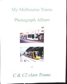 Melbourne Tram Museum
Album, Gus Weir, My Melbourne Trams - C, C1. C2 and E class, 1967 to 2014
Compiled by Gus Weir of the Wellington Tramway Museum, former Wellington tram driver. Comprises some 42 double-sided album sheets for photographs of Melbourne - C, C1, C2 and E class trams. - Scanned into 4 parts as pdf files. Many photos taken in the City area, Some photos by M Hawkins. Part 1 - title sheet, 3001, 3002, 3036, 3003, 3005, 3006, 3008, 3009, 3010, 3013, 3004, 3015, 3015, 3016, 3017, 3020, 3021, 3022, 3023, 3024, 3025, 3026, 3029, 3030, 3032, 3034, 3036. Part 2 - E 6001, 6005, 6002, 6003, 6004, C2 class - 5123, 5113, 5111, 5103, 5106, Yields detailed information about Melbourne , C1, C2 and E class trams.Set of 42 album sheets generally with four photos within a bound album, with many blanks to allow for further photos. Each photo has a label on the rear, with details of the photograph's location, photographer, and date. An insert label on each page gives the tram number, location, and date.tramways, tramcars, albums, melbourne, yarra trams, c class, c1 class, c2 class, e class -
 Eltham District Historical Society Inc
Photograph, Stokes family with horse and sled, Nyora Road, Eltham, c.1950, 1950c
Taken from outside the family home on the southest corner of the intersection of Nyora Road and Pitt Street with Eucalyptus Road, looking northeast across the Stokes Orchard Frank Stokes with children, Dorothy (left), Beryl and David Frank Stokes first traveled to the district by train in 1944 to find land with the intention to establish an orchard. By chance he met Arthur Bird of Bird Orchard (bounded by Pitt Street, Eucalyptus Road and Wattle Grove) and they got talking over their common interest. Arthur put Frank up for the night and pointed out the land, part of Crown Allotment 15, Section 5, Parish of Nillumbik (CA15) somewhat diagonally opposite Bird Orchard. Frank bought the land and for the next two years would travel by train from Melbourne to Eltham every weekend establishing Stokes Orchard and building a home for his family, which they eventually moved into in 1946. In the mid 1970s the Shire of Eltham divided the orchard up into numerous rate-able parcel lots, which became affordable for Frank. As a consequence Stokes Orchard was turned into a housing development by Macquarie Builders and marketed as the Stokes Orchard Estate in two stages; Stage 1 encompassing Scarlet Ash Court, Ironbark Close and Peppermint Grove bounded by Nyora and Eucalyptus roads c.1976 and Stage 2 encompassing Stokes Place, Orchard Way, The Crest and The Lookout bound by Nyora and Diosma roads c.1979. The development of Orchard Way, The Crest and The Lookout did not proceed as planned due to the lack of the sewer along Diosma Road and so many of the proposed lots were incorporated into five-acre parcels instead.Representative of the orchard growing areas of ElthamDigital file only - Digitised by EDHS from a scrapbook (containing commercially printed photos of digital scans) on loan from Beryl Bradbury (nee Stokes), daughter of Frank Stokes.1950, beryl bradbury (nee stokes), beryl bradbury (nee stokes) collection, david stokes, dorothy stokes, eltham, frank stokes, horse, nyora road, sled, stokes orchard -
 Buninyong & District Historical Society
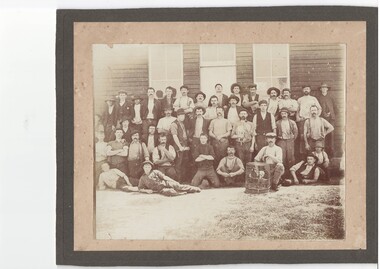
Photograph - Sepia photograph of a group of shearers, location unknown, J.Moyle, Group of shearers, 1910
Photograph is said to include Charles Heather.Original photograph taken c 1910. on reverse "Shearers c 1910 Charles Heather was a shearer" group of shearers., the heather family. clothing and tools. -
 Stawell Historical Society Inc
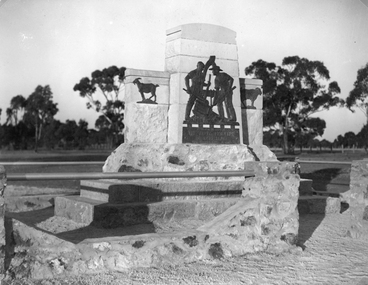
Photograph, Deep Lead Pioneers Memorial c 1936
The memorial was erected in c 1936 by the public to the pioneers of Deep Lead District. The memorial was to commemorate the early pioneers of Deep Lead. The bronze tablet depicts two miners at work, one operating the cradle while the other using the shovel. Behind the two men and partly framing the design, is the windlass set in a fork of a tree. On each side of the main tablature are two figures of goats, one a "Billy goat" the other a "nanny goat". The bronze sculpture is set on a pedestal of Grampian freestone, which is placed on the two steps of granite. The whole memorial is surrounded by an ornate stone fence. The bronze sculpture work was executed by Mr. S. J. Hammond of Melbourne while the stone work was carved and erected by Mr. G. Robson, of Stawell. The shire engineer Mr. C.W.C. Venables assisted with advice when necessary.Black and white photograph depicting the stone Deep Lead Pioneer memorial with native gums in the background. stawell -
 Stawell Historical Society Inc
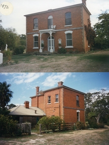
Photograph, Armstrong’s Area Houses c 1990's -- 2 Photos -- Coloured
Residence Fountainhead Brewery Armstrong's Est. c 1872. The rear view photograph shows a more recent renovated building. Some evidence of demolition to rear of building (servants stairs etc.) Following notes taken from information in album 9 - "Compare earlier photos and note balcony etc. Later views, This photo early 2003. Owing to timber decay balcony was removed for safety. Finances permitting complete balcony will be replaced. Twin columns and iron lace are not original. Early description mentions statues in "niches" beside door. Female statue left is original. White pedestal at left was male stature damaged by a falling tree. Both statues were fountains." Photographs taken by Mr. Don Richard and held in Album 9b Armstrong’s Area.Two coloured photographs, of a brick double story building. The front view of the building has 4 windows and 2 doors. Two white columns at the entrance with decorative iron work support the roof of the porch with 2 white chairs and a table on top. Either side of the entrance door are 2 white wall indents "niches" with pot plants. The second photo show the back view of the two story building with a single story building attached that has a tin roof. A timber fence with a gate shows the side entrance to the single story building. 648M NHNN 8H01HPRO3 WIMMERA 1MHGINGstawell -
 The 5th/6th Battalion Royal Victoria Regiment Historical Collection
Plaque - Presentation Plaque, C & D Coy Wark VC Mess "The Achievers"
Large shield shaped presentation plaque with 7 engraved brass plates attached .C & D Coy Wark VC Mess "The Achievers" WO2. D Reuther RQ 1.R.V.R 1986 CPL SCOTT REEVES DPMC WARK CLUB 1987 CPL COLIN DUNPHY BARMAN 1987 CAPT GARY SIMMONS OC D COY 1986/87 SGT D.M. DAVIES PLT SGT 7 PLATOON 1989 CPL P.P. CASSAR SEC COMMANDER 7 PLATOON 1990wark vc club, 1rvr, c&d company -
 Eltham District Historical Society Inc
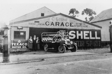
Photograph, C. Stone's Garage, Diamond Creek, c.1928
Believed to be a Chevrolet or Pontiac on the forecourt. Signage for Shell Motor Spirit and Texaco Motor OilBlack and white copy of photo printed on glossy photographic paper 30.5 x 40.5 cm (12 x 16 inch); image size approx. 18.5 x 28 cmc. stone, chevrolet, diamond creek, garage, motor garage, pontiac, service station, shell motor spirit, texaco motor oil -
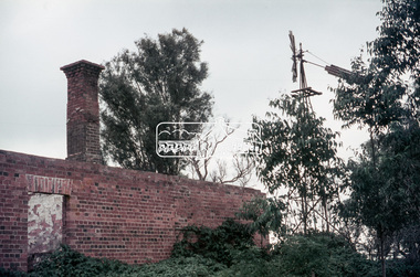
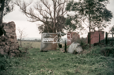
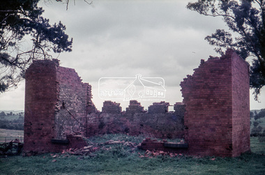
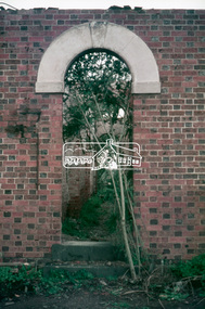
 Eltham District Historical Society Inc
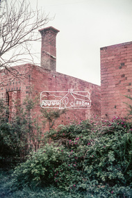
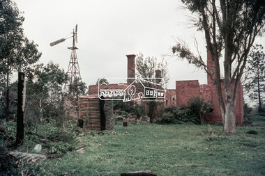
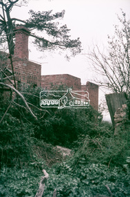
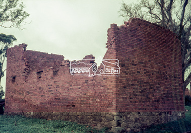
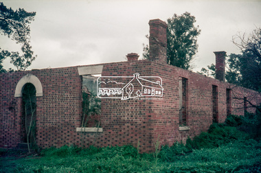
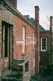
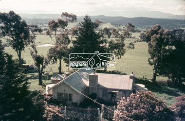
Slide, "Kangaroo Hall" (c.1843-1969), Donaldsons Road, Kangaroo Ground, which was destroyed during the January 8, 1969 bushfire; c.1975, 1975c
Built by James and Isabella Donaldson at the centre of their 1 square mile property southwest of the present day Presbyterian Church. The Donaldsons first arrived in Port Phillip on 17 December 1841. Their first house was a bark hut which was replaced by this substantial brick home around the mid 1840s. James Donladson died 1856. Kangaroo Ground Presbyterian Church http://kgpc.pcvic.org.au/history-2.html Pictures of the farm and homestead (rented by Mr E. Hobson) were published in The Weekly Times, 18 March 1911, p27 1911 'MR. E. HOBSON'S FARM AT KANGAROO GROUND.', Weekly Times (Melbourne, Vic. : 1869 - 1954), 18 March, p. 27. , viewed 29 Feb 2020, http://nla.gov.au/nla.news-article222243528 A letter from Mr Hobson published in the following edition clarified that he only rented the property and that the owner was Mr John Donaldson of Sandringham 1911 'KANGAROO GROUND.', Weekly Times (Melbourne, Vic. : 1869 - 1954), 25 March, p. 47. , viewed 29 Feb 2020, http://nla.gov.au/nla.news-article22224117935 mm colour positive transparency Mount - Agfacolor Service (Blue)bushfire, donaldson home, donaldsons road, isabella donaldson, james donaldson, kangaroo ground, kangaroo hall, victorian bushfires - 1969 -
 Eltham District Historical Society Inc
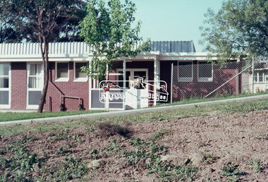
Photograph, Eltham Senior Citizen's Centre, c.1966-c.1968, 1967c
35mm Colour positive transparency Mount - Agfacolor Service (Blue stepped)eltham, senior citizen's centre -
 Eltham District Historical Society Inc
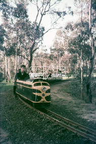
Photograph, Diamond Valley Railway, Eltham Lower Park, c.1966-c.1968, 1967c
35mm Colour positive transparency Mount - Agfacolor Service (Blue stepped)diamond valley railway, eltham lower park -
 Eltham District Historical Society Inc
Photograph, View from Kangaroo Ground Tower, c.1966-c.1968, 1967c
35mm Colour positive transparency Mount - Agfacolor Service (Blue stepped)kangaroo ground, war memorial tower -
 Eltham District Historical Society Inc
Photograph, Kinglake Road, St Andrews, near Mittons Bridge, c.1966-c.1968, 1967c
35mm Colour positive transparency Mount - Agfacolor Service (Blue stepped)inscribed (b) Rolling caster? and 2heidelberg-kinglake road, mittons bridge, st andrews