Showing 4483 items
matching cities and towns
-
 Eltham District Historical Society Inc
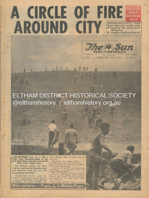
Newspaper - Newspaper articles, Sun News-Pictorial, A Circle of Fire Around City, The Sun News-Pictorial, Friday, March 12, p1, 1965
Various news articles pertaining to the January 1965 Victorian bushfires specifically with a focus on fires at Eltham North. Specific Eltham Shire districts mentioned include Eltham, Diamond Creek, Warrandyte on page 1 and page 3, Warrandyte on page 4 • A Circle of Fire Around City, p1 (Illust.) • A home is saved, p2 (Illust.) • 18 houses, hall and store lost, p2 • Battle for the trees, p3 (Illust.) • Six houses go in two suburbs, p3 (Illust.) • A sleepless town waited, p4 (Illust.) • Fire in the near hills, pp28-29 (Illust.) tom fielding collection, victorian bushfires - 1965, victorian bushfires – 1965, greensborough, diamond creek, warrandyte, eltham, gippsland, romsey, toolern vale, melton, rockbank, laughing waters, ken guest, eltham state school no. 209, a. smith, ray freeman, sassafras, diamond creek-greensborough road, warrandyte hall, bushfire damage – buildings -
 Glen Eira Historical Society
Book - Royal Visit 1901 - HRH The Duke of Cornwall and York
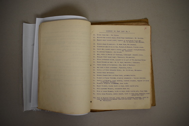
This file contains three items about the visit of Prince George Duke of Cornwall and York (later Prince of Wales, later Geroge V) to Victoria in 1901: 1/A book ‘Addresses to (His Royal Highness) HRH The Duke of Cornwall and York and to His Excellency the Governor-General the Earl of Hopetown from the Municipalities of Victoria' containing copies of the addresses from the municipalities to George and the Governor-General on the inauguration of the Commonwealth of Australia, and the replies of George and the Governor General. The book also contains individual cards on each municipality, including the Shire of Caulfield. The cards contain information such as date of incorporation and population, and the signatures of the Mayors, Councillors and Town Clerks of the cities, towns and boroughs, and the signatures of the Presidents, Councillors and Secretaries of the Shires. The book also contains the signatures of the President, executive committee and secretary of the Municipal Association of Victoria. 2/A research note by Amy MacKintosh on the information on Caulfield Shire contained within the book. 3/A research note by Amy MacKintosh on the circumstances of George’s visit to Australia.royal visits, federation (1901), local government, caulfield, george v, george duke of cornwall and york, mary duchess of cornwall and york, earl of hopetoun, hope john earl of hopetoun, shire of caulfield, governor general, hopetoun, hopetoun lady, caulfield historical society, akhurst a. c., pennington harold, jowett f., slaney h., kirkham c. f., sharp t. c., riddell w. t. c., lempriere john t., wood f. g., bayston w. s., lloyd c., phillips r. l., long j. -
Glen Eira Historical Society
Letter - CAULFIELD CENTENARY - 1957
This file contains seven items: 1/One double sided pamphlet regarding the Caulfield Centenary Carnival at Caulfield Park from 25/10/1957 to 05/11/1957, listing attractions and special events. Includes advertising for Bunny Industries on the back. 2/One pamphlet for the Children’s Carnival at Caulfield Racecourse on 29/10/1957 as part of the City of Caulfield Centenary celebrations. The pamphlet includes a timetable for the day’s events. 3/One six page pamphlet for a film festival organised by the Caulfield Film Society as part of the City of Caulfield Centenary Celebrations. The pamphlet includes a programme for each of the four days of the film festival, 14/10/1957, 17/10/1957, 23/10/1957 and 25/10/1957. The pamphlet also includes information about the Caulfield Film Society regarding their formation, their values, their manifesto and their officials. 4/An eight page programme for the centenary Thanksgiving Service on 13/10/1957 featuring prayers and hymns. 5/Two copies of a pamphlet regarding City of Caulfield Centenary Celebrations from 13/10/1957 to 05/11/1957 created by H.G. Nelson, Town Clerk. Events listed include Thanksgiving Service, Music Festival, Film Festival, Special Centenary Council Meeting, Gymkhana, Parade of Decorated Floats, Spring Flower Show, Massed Bands Display, Display of Art, Naturalisation Ceremony, Solemn High Mass, carnivals and plaque unveiling. 6/One original and one photocopy of an eight page notice paper for the Special Meeting of Caulfield City Council to commemorate the 100th Anniversary of the proclamation and declaration of the Caulfield Road District, to be held on 15/10/1957. The booklet includes the agenda, a council summons, a picture of Caulfield’s City Hall and a list of current and past councillors, chairmen, presidents, mayors and Shire Secretaries and town clerks. 7/A letter addressed to F. Campbell from Hazel Da Costa, dated 07/11/1997 regarding the acquisition of pamphletts for the Caulfield Centenary Carnival. For further information refer to the Oakleigh and Caulfield Times 09/10/1957 and Caulfield-Elsternwick Advertiser 05/11/1957 and 22/10/1957 stored in the Newspaper Archive room 4.caulfield centenary carnival, queen crowning ceremony, dandh bunny pty ltd, caulfield film society, carnegie memorial hall, caulfield park, hawthorn road, balaclava road, glenhuntly road, parades and processions, fire works displays, festivals and celebrations, bunny industries, glen press, hardware stores, builders suppliers, plumbers suppliers, centenary celebration, caulfield centenary, children’s carnival, caulfield racecourse, sinclair a.j.g., sporting events, film festival, new supper room, town hall, methodist hall, saint john hall, birch street, orrong road, princes park, caulfield hospital, daughters e.f., ward miss n., madigan mr. r, ritchie miss e., weichelt mr f., machin l.r., green w.c., jenner e.r., thomas w.r., centenary thanksgiving service, hymns, prayers, naturalisation ceremony, caulfield and district horses and pony club, special centenary council meeting, caulfield horticulture society, saint aloysius church, packer reserve, oakleigh road, caulfield memorial youth centre, commemoration, caulfield road district, mayors, presidents, chairmen, councillors, town clerks, parton e.m., bunny f.c.d., sims h.e., thomson w.r., wallace g.e., gunn e.e., gamble h.a., yorston j.s., handasyde g., murry ross w., stephen j.w., masters s., lloyd j.c., watts thos., watts t., nelson c., webb g.h., stephen f.j., crosbie j.w., watts w.c., holland j.c., lempriere w.g., millar w., newing t. r., ballantyne j., cotton a.d., long j., kirkham c.f., lloyd c.du p., wood f.g., akhurst a.c., riddell w.j.c., sharp t.c., phillips r.l., lempriere j.t., bayston w.s., dunbar a., hall p., saint j., fiske w., thompson h., murphy e.c., eggleston f.w., murray n.l., wood h.s., tyner w., wharington w.a., packer j.t., falls t., brooks w.r., lord r.h., morris a.e., page j.w., porter f.w., england e.f.s, patton r.t., mcculloch r., richie h.g., packer j.t., mackinnon d.c., mackinnon g.a., smith h.c.h., shillabeer f.e., pullman c.a., stewart l.mcr., tyers s.w., morris t.w., prior p.l., brooks w.r., webster h.c., sims h.e., prior p.l., thomson w.r., gunn e.e., parton e.m., wallace g.e., dempsey w., hart j., jowett f., briggs j.r., nelson h.g. -
 City of Ballarat
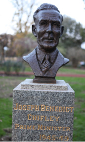
Public Artwork, Joseph Benedict Chifley (Prime Ministers' Walk) by Ken Palmer, 1946
Joseph Benedict 'Ben' Chifley, Australia’s 16th Prime Minister. A railway engine driver in his home town of Bathurst, New South Wales. The Prime Ministers Avenue is a collection of bronze bust portraits of the Prime Ministers of Australia, located at the Ballarat Botanical Gardens in Ballarat, Victoria. The Prime Ministers' portraits are commissioned after the incumbent term of each Prime Minister by the City of Ballarat. The City of Ballarat has taken responsibility for commissioning the busts after funds set aside by politician Richard Armstrong Crouch were exhausted in 2014. Crouch originally donate money to pay for six busts, the first of which was unveiled in 1940. The collection of prime ministers' busts are unique in Australia, representing the only sculptural portrait collection of all past Australian Prime Ministers. The different styles used reflect the unique artistic practices of the selected artists; textures, sizes and features and proportions are used by the artists to interpret the characteristics of each of the subjects.The artwork is of historic and aesthetic significance to the people of BallaratBronze bust cast on granite plinthJoseph Benedict Chifley Prime Minister 1945-49prime minister, joseph benedict 'ben' chifley, ben' chifley, bathurst -
 Ballarat Heritage Services
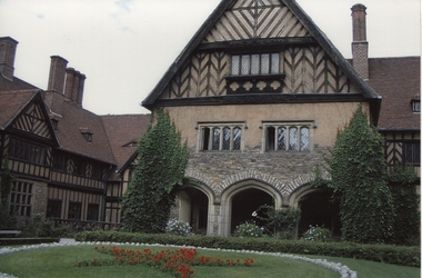
Photograph - digital photographs, Potsdam, Cecilienhof Palace, 10/2007
It was at the “Schloss Cecilienhof” (Cecilienhof Palace) that Churchill, Truman and Stalin met from June 17 to August 2, 1945, for the Potsdam Conference. Cecilienhof Palace in the New Garden was the last Hohenzollern palace, built for the crown prince during the years 1913-1917. The end of monarchy in 1918 was another hard blow for the town, which so far was shaped by the Royal Court, garrison and administration. During the night of April 14, 1945, a British air raid destroyed large parts of the inner city of Potsdam. Battles against Soviet military units during the last days of April 1945 caused still more and heavy damages. The parks and their palaces remained almost unscathed. After the war ended, from the end of July until the beginning of August 1945, the Potsdam Agreement was negotiated and signed between Churchill, Truman and Stalin in Cecilienhof Palace. http://www.historicgermany.travel/historic-cities/potsdam/history Colour photograph of, Cecilienhof Palace, Potsdampotsdam -
 Wodonga & District Historical Society Inc
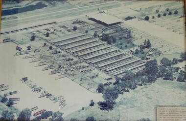
Photograph - W. G. Page Saleyards, Wodonga, c1980
William George Page was Shire and City Engineer in Wodonga from 1965 until 1989. When he arrived the Shire of Wodonga had a population of 17,000 people. In 1966 Wodonga was selected as a city for special growth assistance. In 1972 Bill Page presented a new Town Plan to the Wodonga Council. Over the ensuing years he dedicated himself to bring this plan to fruition. He often had to argue and campaign with the Albury-Wodonga Corporation to push for the interests of development in Wodonga. This included winning a planning appeal to allow the saleyards to be relocated to Bandiana on the outskirts of Wodonga. Bill Page retired on health grounds in July 1989. The Council honoured him with a farewell dinner and renamed the saleyards at Bandiana the W.G. Page Saleyards in his honour.The Mayor , Cr Valentina Gillard, said "Every development in Wodonga in the past 24 years has a bit of Bill Page in it". William Page died 3 months later at 58 years old.This image depicts an important centre in the development and support of the livestock industry around Wodonga.An aerial photograph of the W. G. Page Saleyards in Wodonga. It has been mounted in a wooden frame.On a sign attached to the photo frame: "This photo of the W.G. Page Saleyards has been donated to the people of Wodonga from Mrs Pat Page and Family. The saleyards were named after the late Bill Page, City Engineer of Wodonga Council for 25 years until his death".w. g. page saleyards, wodonga saleyards, william george page -
 Flagstaff Hill Maritime Museum and Village
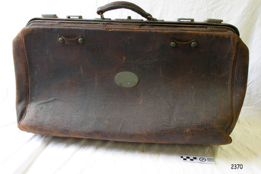
Functional object - Portmanteau
The etymology of the word portmanteau: A portmanteau was a travelling bag used as a mailbag. During the eighteenth and nineteenth centuries, both newspapers and letters were transported in these leather mailbags that opened into two sections. A portmanteau is a word created by the blending of two other words in terms of the sounds and meaning. Portmanteau itself is a portmanteau; made up of the French ‘porter’ meaning ‘to carry’ and ‘manteau’ meaning ‘cloak’. The other meaning of this word is ‘a travelling case or bag' but was coined by Lewis Carroll with its new meaning in 1882. History: English merchant Thomas Witherings established mail routes throughout Europe in the 1620 s. He drew up a proposal in 1635 for an English mail system based in London in which portmanteau (containing 2 leather bags lined with cotton) could travel to European towns with sealed bags of mail for protection against spies. The system was put into motion and some 26,000 letters were mailed safely and unopened between London and European towns each week. In the nineteenth century, the official portmanteau was used to carry the mail, letters and newspapers on Americas New England stagecoaches that travelled the postal routes. Before 1789 newspapers were mostly excluded from the mail and the official portmanteau. After the first United States Congress (1789–1791) the postmaster general allowed printers free postage to communicate reports and articles of Congressional informational newspapers with other publishers in other towns and cities for distribution. Example of a mid-20th-century leather bag not connected to a person of significance from history or a historic event. The significance lies in the historic social aspect of this type of bag and how it got its name. This type of bag was popular from the mid 19th century for personal use and fell out of Portmanteau soft leather bag with lock, leather handles (one broken) and with metal plate on front.No inscription flagstaff hill, warrnambool, shipwrecked-coast, flagstaff-hill, flagstaff-hill-maritime-museum, maritime-museum, shipwreck-coast, flagstaff-hill-maritime-village -
 Flagstaff Hill Maritime Museum and Village
Functional object - Portmanteau, 1930-1950
The etymology of the word portmanteau: A portmanteau was a travelling bag used as a mailbag. During the eighteenth and nineteenth centuries, both newspapers and letters were transported in these leather mailbags that opened into two sections. A portmanteau is a word created by the blending of two other words in terms of the sounds and meaning. Portmanteau itself is a portmanteau; made up of the French ‘porter’ meaning ‘to carry’ and ‘manteau’ meaning ‘cloak’. The other meaning of this word is ‘a travelling case or bag' but was coined by Lewis Carroll with its new meaning in 1882. History: English merchant Thomas Witherings established mail routes throughout Europe in the 1620s. He drew up a proposal in 1635 for an English mail system based in London in which portmanteaux (containing 2 leather bags lined with cotton) could travel to European towns with sealed bags of mail for protection against spies. The system was put into motion and some 26,000 letters were mailed safely and unopened between London and European towns each week. In the nineteenth century, the official portmanteau was used to carry the mail, letters and newspapers on Americas New England stagecoaches that travelled the postal routes. Before 1789 newspapers were mostly excluded from the mail and the official portmanteau. After the first United States Congress (1789–1791) the postmaster general allowed printers free postage to communicate reports and articles of Congressional informational newspapers with other publishers in other towns and cities for distribution. Example of a mid-20th-century leather bag not connected to a person of significance from history or a historic event. The significance lies in the historic social aspect of this type of bag and how it got its name. This type of bag was popular from the mid 19th century for personal use and fell out of favour in until the 1950s and the origin and meaning of the word used to describe this type of leather bag "portmanteau". Portmanteau leather bag, with brass oval badge, tan interior with compartment separator. Inscribed "Allchin Bros Makers Ballarat". flagstaff hill, warrnambool, shipwrecked-coast, flagstaff-hill, flagstaff-hill-maritime-museum, maritime-museum, shipwreck-coast, flagstaff-hill-maritime-village, portmanteau, allchin bros -
 City of Greater Bendigo - Civic Collection
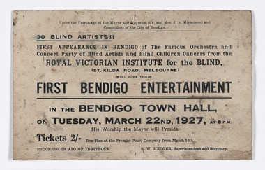
Memorabilia - Ticket, First Bendigo Entertainment
Travelling entertainment has been one popular way that charities have been able to raise revenue over the past 170 years. The Royal Victorian Institute for the Blind toured regional Victoria regularly to help raise awareness, showcase their talents and fundraise to provide care and education for vision impaired men, women and children. Double sided printed ticket for a concert in the Bendigo Town Hall featuring blind artists and dancers from the Royal Institute of the Blind.Obverse; Under the Patronage of the Mayor and Mayoress (Cr, and Mrs J. A. Michelson) and / Councillors of the City of Bendigo / 30 Blind Artists !! / FIRST APPEARANCE IN BENDIGO of The Famous Orchestra and / Concert Party of Blind Artsits and Blind Children Dancers from the / ROYAL VISTORIAN INSTITUTE for the BLIND, / (ST KILDA ROAD MELBOURNE) / WILL GIVE THEIR / FIRST BENDIGO ENTERTAINMENT / IN THE BENDIGO TOWN HALL, / on TUESDAY, MARCH 22nd, 1927, at 8PM / His worship the Mayor will Preside / Tickets 2/- box plan at the Premier Piano Company from March 14th. / PROCEEDS IN AID OF INSTITUTE S.W Hedger, Superintendent and Secretarymayor and mayoress michelson, vision australia, city of bendigo town hall, city of greater bendigo community partnerships, city of greater bendigo events -
 City of Ballarat
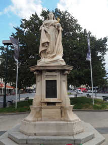
Public Artwork, Sir Edgar Bertram MacKennal, Queen Victoria Memorial Statue by Bertam MacKennal, 1902
The Queen Victoria Monument by Australian Sculptor Sir Bertam MacKennal has a granite plinth with 4 bronze picture plates and granite bowl. The work was once a drinking fountain with decorative bronze spouts and taps set into the columned granite base. Queen Victoria died 22 January 1901, this work was commissioned and gifted to the City of Ballarat by the Woman’s Christian Temperance Union. This work marked the end of her long reign on the English throne and as Empress of the British Empire including Australia. This magnificent statue commemorates the reign of Queen Victoria (1837 - 1901), and is located in Sturt Street, Ballarat, just outside the Town Hall. Listed on the Victorian Heritage Database (B7272), the Queen Victoria Monument is significant to the people of Victoria. The Queen Victoria Monument, Ballarat, is a key component of Sturt Street in Ballarat, a notable streetscape of the late Victorian era. It represents a pivotal element in the extensive series of public art forms erected during the late nineteenth century in the heyday of Ballarat and added to during the twentieth century. The Queen Victoria Monument is an over life size statue mounted on a freestone pedestal containing four bronze relief interpretive plaques. It is situated in front of the Ballarat Town Hall, a prominent position on the wide notable picturesque boulevard of Sturt Street. The presence of the monument in the notable Sturt Street gardens precinct together with other significant statues is of importance. The Queen Victoria Monument at Ballarat is historically significant as a fine example of a tribute to the reigning monarch, initiated by citizens, on the occasion of her Diamond Jubilee, prior to her death. It reflects the fervour of the citizens of the town that played an important role in the development of the State of Victoria during the latter half of the nineteenth century. The Monument is important for its aesthetic characteristics in that it displays a combination of excellent examples of the artistry and technical skills of the sculptor E.B. MacKennal. These elements are evident in design, carving, and in casting of relief modelling.Sicilian marble statue of Queen Victoria with hand outstretched holding the Sovereign's Orb with small gold angel figure. Includes granite plinth with 4 bronze elements and granite bowl. Victoria Dei Gratia Britt Regina Fid. Def. Ind. Imp. 1900. Incorporates four fine bronze scenes from her life; Accession to the Throne (1837), Coronation (1838), Diamond Jubilee (1897) and Signing of the Constitution of the Australian Commonwealth (1900).queen victoria -
Port Melbourne Historical & Preservation Society
Photograph - Bay Street shops, Charles Nettleton, 1890s
This photograph was taken by Charles NETTLETON (1826-1902), a prominent Melbourne photographer who recorded the city’s rapid growth from a small town into a metropolis. He was the special photographer for the government and the Melbourne Corporation, and documented of the built environment and major public works throughout Melbourne from when he arrived to Victoria in 1854. Nettleton is credited for having photographed the first Australian steam train, the Melbourne-Sandridge (Port Melbourne) line, which opened in 12 September 1854; the first cricket team to come to Australia on the ss Great Britain in 1861; and Ned KELLY while Nettleton worked as a police photographer.Bay Street shops, 1875:- original Charles NETTLETON print showing west side of Bay Street: Collings & Son, Butcher; Cranston, Paperhanger; Mrs T CLAY; Johnny ALLSORT's Pawn Office; H. DAVENPORT, Clothing; G. RANSOM, Hardware; A.E. AITKEN, Auctioneer; Mrs A. BROWN, Haberdashery; F.C. FORSTER; Marshal, Printer; John PARRY (or BARRY), General Store; E & M RICE. The house is on the site of the 1912 Post Officebuilt environment - commercial, charles nettleton, theresa clay, collings & son, cranston, h davenport, g ransom, alexander ebling aitken, mrs a brown, john parry, john barry, e & m rice, f c forster, johnny allsorts pawnbroker -
 Glen Eira Historical Society
Album - Album page, London Tavern, Hawthorn Road, Circa 1972
This photograph is part of the Caulfield Historical Album 1972. This album was created in approximately 1972 as part of a project by the Caulfield Historical Society to assist in identifying buildings worthy of preservation. The album is related to a Survey the Caulfield Historical Society developed in collaboration with the National Trust of Australia (Victoria) and Caulfield City Council to identify historic buildings within the City of Caulfield that warranted the protection of a National Trust Classification. Principal photographer thought to be Trevor Hart, member of Caulfield Historical Society. Most photographs were taken between 1966-1972 with a small number of photographs being older and from unknown sources. All photographs are black and white except where stated, with 386 photographs over 198 pages. Glen Eira Heritage Management Plan 1996 by Andrew Ward The 1857 rate book indicates that the major portion of the District was under pasture, although a considerable portion was cultivated. There were 159 houses, huts and tents whose occupants were mainly occupied on the land. If "Camden Town" was the principal commercial focus for the District in 1857, it was to remain so in later years, incorporated today in the Glenhuntly Road centre which extends more or less continuously from Elsternwick to Bambra Road. The Caulfield State School of 1877, the horse tramway of 1889 and subsequently the electric trams were all events confirming the importance of Glenhuntly Road and the fledgling community of "Camden Town" wherein the City's commercial centre has its origins. It is recalled, today, by their presence, and also by the "London Tavern" in Hawthorn Road, established by John Guess in 1873. Dr Geulah Solomon's 4 volume book "Caulfield's Heritage" Vol 1 p 93: "A modern hotel presently on the site continues the name of the London Tavern." That was true until recent years as the hotel is named The Camden Hotel now (2021).Page 81 of Photograph Album with one landscape photograph of the front of the London Tavern with handwriting on the edge of the photograph.Hand written: LONDON TAVERN HOTEL 1937 [on bottom edge of photo] / 81 [bottom left] trevor hart, caulfield, hawthorn road, london tavern, camden town, john guess, hotels, pubs, victorian, 1870's, 1930's, sycamore street, the camden hotel -
 Warrnambool and District Historical Society Inc.
Inventory of Old Museum, Gaspars Modern Print, 1972
This inventory of the contents of the old Museum in Warrnambool dates from the 1920s. A Mechanics Institute under the management of a local committee was established in Warrnambool in 1854 and a Mechanics Institute building was erected in Liebig Street in 1871 (site of present Municipal Library). Museum items and art works began to be collected and housed in the Mechanics Institute building at that time under the care of a committee member and local policeman, Joseph Archibald. This collection did not survive in any significant form after Archibald left the town but it was revived and vastly expanded when he retired and returned to Warrnambool in 1880. Archibald is regarded as the founder of the Museum which officially dates from 1883. In 1910 the Warrnambool Town Council took over the management of the Mechanics Institute, including the Museum collection. This museum continued until 1963 and was a much-loved institution in the city. The contents of the old Museum were dispersed, with many items lost but a considerable portion of the collection was under the care of Warrnambool Art Gallery and John Welsh, the Director in the 1970s, in an effort to keep the records of the old Museum intact, had the 1920s inventory reprinted. This inventory of Warrnambool’s old Museum is of considerable historical importance as it is an almost complete record of the Museum’s contents in the 1920s and so is very useful to researchers today.This is an inventory of 190 pages with a cardboard backing. The pages have three punched holes on the left side and are tied together with black and white cotton cord. At the front of the pages is a plastic envelope with a heading. The pages contain typed material, mostly in mauve ink and these are copies of the original typing. The typing on some pages is very faint and two pages have been re-copied to make them more legible. Warrnambool Art Gallery Old Records of the Warrnambool Museum collected by John A.Welsh, Director, and restored by Gaspars Modern Print 25th September 1972. old museum, mechanics institute building, history of warrnambool, joseph archibald -
 Kiewa Valley Historical Society
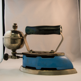
Iron Hand Kerosene, mid to late 1900s
The 1950's saw a revolution in small appliances for use in the average household. This hand held self heating(kerosene) iron was introduced as a time saving and more convenient iron for pressing clothes and other cloth fabrics. It replaced irons needing a separate fire source to heat the ironing plate. These irons continued to be in service, even when electricity was available in cities and larger rural towns (domestic electric steam irons were invented in 1938). This item was used before and during the electricity supplies available from the Kiewa Hydro Electricity Scheme. These irons remained in use within regional rural areas that had limited or unreliable electrical reticulation.In the 1950s and later the Kiewa Valley was still a relatively isolated region which was home to rural properties and small settlements. The availability of electricity and or the financial means to afford new types of electric hand irons ensured that older and sometimes less efficient ironing remained for an extended period covering the 1960s to 1970s. Kerosene products, such as this kerosene iron was a cheaper method for farm based domestic and other rural activities requiring a heat source. The use of kerosene as a heat/light source was able to be supplied in bulk and able to be used when floods severed vital roads into this region. The supply of electricity was in summer time subject to interruption from bush fire damaged wooden poles carrying the electrical cables. Self sufficiency by rural populations was the backbone of survival and the ability to store energy sources "on the farm" was a prerequisite of isolated regions, such as the Kiewa Valley, circa 1950s.This Coleman kerosene iron has a solid steel chrome plated(press) base with a painted (blue) wooden handle. The handle is stud fastened onto an oblong shaped rolled steel handle frame and screwed (two screws) onto the base plate. Both the heating plate and the top securing plate are shaped similar to a river boat. The main housing enclosing the heating element is enamel coated(blue in colour) steel and has a half hole for lighting the kerosene at the rear end. Behind the handle and protruding upwards is a stainless steel fully enclosed container (bowl shaped) for the main supply of kerosene to the burner or generator(enclosed within the main body of the iron. The bowl has an air valve and inlet for pressurised air intake (hand pump) On the bottom rear of the fuel bowl there is a screw regulated fuel pump. The fuel heated base plate provides the heat for this advertised "self heating iron(instant lighting). See KVHS 0347B- Instruction sheet; KVHS 0347C- Wrench; and KVHS 0347D Fuel can.Stamped on the base plate of the handle, front region "COLEMAN LAMP & STOVE CO." below this "WICHITA KAN" below this"TORONTO CAN". In the middle of the handle base and in larger print "COLEMAN Instant-Lite" At the rear location in large print "MODEL 4" in smaller print below "MADE IN U.S.A." below this "PAT#1718473"household appliances, alternative non electrical ironing appliances, domestic appliances, kerosene appliances -
 Warrnambool and District Historical Society Inc.
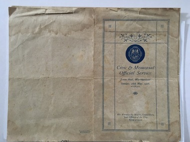
Document, Civic & Memorial Official Services 1918, 1918
These are two programmes of the Civic and Memorial Official Service held in the Warrnambool Town Hall on 26th May 1918. The service was held for two purposes. One was to celebrate the gazetting of Warrnambool as a city, two days earlier, on 24th May 1918. The other was to offer prayers and remember those on active service in World War One and those who had died in the war and to pray for the war to end. (World War One came to an end in the November of 1918). The service on 26th May in Warrnambool was conducted by the ministers of churches in Warrnambool and attended by the Mayor and Councillors and Council workers. A collection was taken up at the service for the British Red Cross Society. The Mayor at the time was William Swinton.This program is of considerable interest as it brings to our attention two events of importance in our history – Warrnambool becoming a city in 1918 and the city’s involvement in World War One and the long-term effects of this war on all settlements in Australia. It also highlights the importance at the time of the Christian religions in Australia.These are two copies of the programme of the 1918 Warrnambool Civic and Memorial Service. The programme is one sheet of buff-coloured paper folded in two to make four pages. There is blue printed material on three of the pages. The front page has the crest of the City of Warrnambool with blue edging and some ornamental scrolls. One programme is tattered at the edges. The two programmes have been glued together at the bottom left corner and have been partly mounted on a piece of white card. warrnambool city council, program civic memorial service 1918 -
 Kew Historical Society Inc
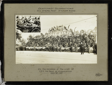
Photograph, The Sears Studio, Centenary Celebrations : Kew "Strong Post" St Kilda Road, 1934
Cr. W.D. Vaughan in 'Kew's Civic History' (1960) records that: "In connection with the Melbourne Centenary Celebrations in 1934, the Kew Council decided to organise a strong post as an appropriate gesture of welcome to H.R.H. the Duke of Gloucester. Also that the municipality be represented by a symbolic floral float in the Royal pageant. This was a striking entry and won first prize, and evoked much comment on account of its originality and truly Australian motif." The photograph of the Kew Strong Post was once part of the Municipal Collection of the former City of Kew and was presented to the Kew Historical Society before the move from the Walpole Street (Kew) Town Hall to new Civic offices in Charles Street in 1971.Historic photograph of participation by the City of Kew in celebrations for a royal visitFramed and glazed photograph on its original inscribed mount and original frame of the Kew "Strong Post" in St Kilda Road on the occasion of the visit to Melbourne of the Duke of Gloucester. The photograph has two components, at the upper left is a photo of the royal carriage while the man photo shows the people of Kew on a decorated 'Strong Post' on St Kilda Road, along which the procession progressed. T"Centenary Celebrations / Kew "Strong Post" St Kilda Road / On the occasion of the visit of / H.R.H. The Duke of Gloucester / October 18th 1934."royal visits - melboure - 1934, duke of gloucester, kew (vic.) — municipal collection -
 National Wool Museum
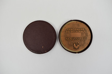
Medallion, CENTENAIRE DU DELAINAGE MAZAMET, 1951
This medallion was struck to celebrate the 100th anniversary of fellmongering in Mazamet in 1951. Fellmongering - In French, ‘delainage” means, literally, ‘de-wooling'. It is the industrial process of separating wool from sheepskins. In the 19th century, the southern French town of Mazamet became the world centre of délainage and played an important part in the Australian wool industry. At one time Mazamet was reputed to be the 15th richest town in Europe, and it was said that the town’s branch of the Banque Nationale de Paris (French banking firm) was the second largest in France. At its height, Mazamet had 48 fellmongeries and imported more than 100,000 tonnes of sheepskins a year from the southern hemisphere, mostly from Australia and Argentina. It also supported numerous associated industries such as tanneries, spinning mills and clothing manufacturers. In the 1980s Mazamet’s fellmongering industry fell into decline under pressure from environmental concerns and cheap imports. The town’s last two fellmongeries closed in 2004. The town continues to have a strong relation to Australia, with street names such as, Rue de Australie, Adelaide, Brisbane, Melbourne and Sydney in recognition of a connection to the two distant lands. Today, half a century since wool importation largely ended, there remains a link to the past. Elite quality leather and woollen clothing companies such as Hermes and Chanel still source much of their stock in Mazamet. This medallion was presented to William Haughton and Co. who were one of Australia’s largest wool-buying companies of the first half of the 20th century. Wm Haughton had a major presence in Geelong and its “SKINS WOOL HIDES TALLOW etc.” signs were prominent on railways stations throughout the Western District and beyond. Haughtons had branches in all Australian capital cities, New Zealand, London and Bradford. Its agents in Mazamet were Maison Louis Maffre, an enterprise founded by M. Louis Maffre, mayor of Mazamet from 1912 to 1919. This medallion was donated to the National Wool Museum by the family of Sir Robert Southey AO CMG, former managing director of Wm Haughton & Co.Bronze medallion contained within purple case. On one side of the medallion, a mill worker is seen scraping the wool off the treated sheepskin. On the reverse the inception can be read.Wording: CRESCAM ET LUCEBO // CENTENAIRE / DU DELAINAGE / MAZAMET // 1851-1951. Smooth edge stamped with a cornucopia and the inscription BRONZEmazamet, fellmongering, délainage -
 Kew Historical Society Inc
Plan, Melbourne & Metropolitan Board of Works : Borough of Kew : Detail Plan No.1302, 1910
The Melbourne and Metropolitan Board of Works (MMBW) plans were produced from the 1890s to the 1950s. They were crucial to the design and development of Melbourne's sewerage and drainage system. The plans, at a scale of 40 feet to 1 inch (1:480), provide a detailed historical record of Melbourne streetscapes and environmental features. Each plan covers one or two street blocks (roughly six streets), showing details of buildings, including garden layouts and ownership boundaries, and features such as laneways, drains, bridges, parks, municipal boundaries and other prominent landmarks as they existed at the time each plan was produced. (Source: State Library of Victoria)This plan forms part of a large group of MMBW plans and maps that was donated to the Society by the Mr Poulter, City Engineer of the City of Kew in 1989. Within this collection, thirty-five hand-coloured plans, backed with linen, are of statewide significance as they include annotations that provide details of construction materials used in buildings in the first decade of the 20th century as well as additional information about land ownership and usage. The copies in the Public Record Office Victoria and the State Library of Victoria are monochrome versions which do not denote building materials so that the maps in this collection are invaluable and unique tools for researchers and heritage consultants. A number of the plans are not held in the collection of the State Library of Victoria so they have the additional attribute of rarity.Original survey plan, issued by the MMBW to a contractor with responsibility for constructing sewers in the area identified on the plan within the Borough of Kew. The plan was at some stage hand-coloured, possibly by the contractor, but more likely by officers working in the Engineering Department of the Borough and later Town, then City of Kew. The hand-coloured sections of buildings on the plan were used to denote masonry or brick constructions (pink), weatherboard constructions (yellow), and public buildings (grey). The absence of buildings and or property in Kew facing the Yarra is the most notable feature of this plan. Walmer Street and its bridge stretched, then and now, from Studley Park Road to Victoria Street, Richmond. On the Richmond side of the Yarra, there was evidence in 1904 of industry (‘Wool shed’; Soap Works’) and entertainment (‘Skittle Alley’). In reality, another Plan (No.1303) shows Chinese Gardens bordering the Yarra on the Kew side and buildings in Young Street.melbourne and metropolitan board of works, detail plans, mmbw 1302, cartography -
 Kew Historical Society Inc
Plan, Melbourne & Metropolitan Board of Works : Borough of Kew : Detail Plan No.1571, 1904
The Melbourne and Metropolitan Board of Works (MMBW) plans were produced from the 1890s to the 1950s. They were crucial to the design and development of Melbourne's sewerage and drainage system. The plans, at a scale of 40 feet to 1 inch (1:480), provide a detailed historical record of Melbourne streetscapes and environmental features. Each plan covers one or two street blocks (roughly six streets), showing details of buildings, including garden layouts and ownership boundaries, and features such as laneways, drains, bridges, parks, municipal boundaries and other prominent landmarks as they existed at the time each plan was produced. (Source: State Library of Victoria)This plan forms part of a large group of MMBW plans and maps that was donated to the Society by the Mr Poulter, City Engineer of the City of Kew in 1989. Within this collection, thirty-five hand-coloured plans, backed with linen, are of statewide significance as they include annotations that provide details of construction materials used in buildings in the first decade of the 20th century as well as additional information about land ownership and usage. The copies in the Public Record Office Victoria and the State Library of Victoria are monochrome versions which do not denote building materials so that the maps in this collection are invaluable and unique tools for researchers and heritage consultants. A number of the plans are not held in the collection of the State Library of Victoria so they have the additional attribute of rarity.Original survey plan, issued by the MMBW to a contractor with responsibility for constructing sewers in the area identified on the plan within the Borough of Kew. The plan was at some stage hand-coloured, possibly by the contractor, but more likely by officers working in the Engineering Department of the Borough and later Town, then City of Kew. The hand-coloured sections of buildings on the plan were used to denote masonry or brick constructions (pink), weatherboard constructions (yellow), and public buildings (grey). This plan is the other half of Plan No.1571 representing the constructions to the west of Wellington Street before and in 1903/4. This plan represents the built environment in Edgevale Road, Wellington Street, Atkins Street, Annadale Street, Mortimer Street, and Cotham Road. Whereas there are smaller allotments and more modest housing stock facing Edgevale Road, larger blocks and more substantial houses are represented facing Cotham Road.melbourne and metropolitan board of works, detail plans, mmbw 1571, cartography -
 Kew Historical Society Inc
Plan, Melbourne & Metropolitan Board of Works : Borough of Kew : Detail Plan No.1575, 1905
The Melbourne and Metropolitan Board of Works (MMBW) plans were produced from the 1890s to the 1950s. They were crucial to the design and development of Melbourne's sewerage and drainage system. The plans, at a scale of 40 feet to 1 inch (1:480), provide a detailed historical record of Melbourne streetscapes and environmental features. Each plan covers one or two street blocks (roughly six streets), showing details of buildings, including garden layouts and ownership boundaries, and features such as laneways, drains, bridges, parks, municipal boundaries and other prominent landmarks as they existed at the time each plan was produced. (Source: State Library of Victoria)This plan forms part of a large group of MMBW plans and maps that was donated to the Society by the Mr Poulter, City Engineer of the City of Kew in 1989. Within this collection, thirty-five hand-coloured plans, backed with linen, are of statewide significance as they include annotations that provide details of construction materials used in buildings in the first decade of the 20th century as well as additional information about land ownership and usage. The copies in the Public Record Office Victoria and the State Library of Victoria are monochrome versions which do not denote building materials so that the maps in this collection are invaluable and unique tools for researchers and heritage consultants. A number of the plans are not held in the collection of the State Library of Victoria so they have the additional attribute of rarity.Original survey plan, issued by the MMBW to a contractor with responsibility for constructing sewers in the area identified on the plan within the Borough of Kew. The plan was at some stage hand-coloured, possibly by the contractor, but more likely by officers working in the Engineering Department of the Borough and later Town, then City of Kew. The hand-coloured sections of buildings on the plan were used to denote masonry or brick constructions (pink), weatherboard constructions (yellow), and public buildings (grey). Plan No.1575 shows that in the area bounded by Wellington Street, Edgevale Road, Glenferrie Road, and Cotham Road, there had already been significant subdivision of land and houses constructed. As one of the highest points in Kew, as expected, there were already some significant mansions built on large allotments of land. Many of these mansions are identified by name on the plan such as ‘Kelso’, ‘Abbotsford’, ‘Clarendon’ and ‘Ashlyn’ in Cotham Road. Other houses of equal size are unnamed on the plan.melbourne and metropolitan board of works, detail plans, maps - borough of kew, mmbw 1575, cartography -
 Wodonga & District Historical Society Inc
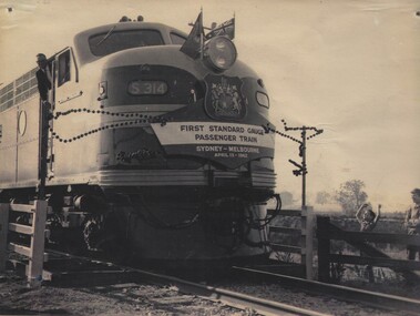
Photograph - Fred Rochow Railways Collection - First standard gauge passenger train from Sydney to Melbourne, 13 April 1962
The Fred Rochow Railways Collection incorporates photos related to the operation of the Wodonga Railway Station including different types of trains and railways staff C. 1930 – 1990. It was donated to the Wodonga Historical Society by Fred Rochow, a railwayman who spent many years based in Wodonga. He joined the Victorian Railways on 17th June l947 and retired in 1988. For some time, he was a member of the Australian Federated Union of Locomotive Enginemen and served a term as a member of the Trades Hall Council. He had an extensive knowledge of the struggles that took place to achieve better conditions for railway workers. Fred worked for many years as a fireman and then worked his way up the ranks to driver, experiencing many changes from the days of steam locomotives through to diesel trains, locomotives and even the modern XPT train. He worked throughout Victoria at different stages of his career, with his final working years focused on the northeast of Victoria and the Albury to Melbourne line. After his retirement, Fred continued to share his love of steam miniature trains with the community. S Class Locomotives - The eighteen members of the S Class were ordered in two batches by the Victorian Railways from Clyde Engineering for express passenger and freight workings, with the final eight locomotives ordered specifically to work the North-East standard gauge line. Many were named after prominent Victorians.This collection has local and statewide significance as it captures images of trains, locomotives and personnel who operated the railway services in Wodonga and throughout Northeast Victoria. The railways played a critical role in opening up Victoria and connecting Australia for trade, business, social communication and transport.The first standard gauge passenger train from Sydney to Melbourne pulled by Locomotive S314. This was made possible when part of Australia's gauge problem was solved with the construction of a new standard gauge line. The new line was a 317 km long line running from Albury, NSW, parallel to the existing broad gauge line to Melbourne, connecting Australia's two largest cities by standard gauge. S314 entered service on 24 April 1961 and was named after Sir John O'Shannassy who was the second Premier of Victoria. The S314 pulled the first passenger train to travel straight through from Sydney to Melbourne on 13 April 1962. On the morning of 7th February 1969, the southbound Southern Aurora collided head-on with a northbound goods train near Violet Town, Victoria. The Locomotive S314 was hauling the goods train and was destroyed by the impact of the collision. On front of locomotive "S314" On banner below Coat of Arms "FIRST STANDARD GAUGE PASSENGER TRAIN / SYDNEY - MELBOURNE/ APRIL 13 - 1962"railways wodonga, fred rochow, walker rail motor vehicles, wodonga to tallangatta rail service -
 Melbourne Tram Museum
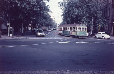
Slide - Set of 3, Keith Caldwell, 9/03/1960 12:00:00 AM
Set of 3 Agfa Colour slide, cardboard mount, by Keith Caldwell of:- .1 - SW6 889 turning from Collins St into Gisborne St, route 42, Month Albert. Has a Stonefell advert on the sides and others which are not readable. Dated 10 March 1960. .2 - W5 767 east bound in Collins St, east of Swanston St showing East Preston - Bell St, route 91A and SW6 895 westbound, showing Hanna St Depot?. Moomba Street decorations in the view. Has the Town Hall and the Manchester Unity Building. Dated 9 March 1960. .3 - W2 475 east bound, as for .2 showing East Preston Bell St, route 9A. Note the tramcar number is above the headlight. Three other trams are inbound, the last one showing route 47, City. Dated 9 March 1960.hand stamped "9 Mar '60"trams, tramways, collins st, mont albert, route 42, gisborne st, town hall, route 9a, hanna st depot, east preston, moomba, w2 class, w6 class, sw6 class, w5 class, tram 889, tram 767, tram 895, tram 475 -
 Glenelg Shire Council Cultural Collection
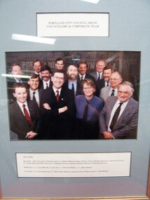
Photograph - Photograph - Portland City Council, 1992/93, Councillors and Corporate Team, n.d
Glenelg Shire Council RecordsFront: Portland City Council 1992/93, Councillors and Corporate Team (upper centre, label) Left to Right/Back Row: Greg Trevaskis (Chief Executive), Cr. Robert Menzel (Deputy Mayor), Trevor Hornby (Director Corporate Services), Cr. Phillip Kelly, Bill Hebb (Director Community Services) and Ross Morgan (Director Technical Services). Middle Row: Cr. Lynn Murrell, Cr. Des Hein, Cr. Bernard Wallace, Cr. Jeffrey Baulch. Front Row: Cr. Darrell Morrison, Cr. Mike Noske (Mayor), Lelia Pop (Town Planner) and Cr. Keith Wilson. -
 Kew Historical Society Inc
Plan, Melbourne & Metropolitan Board of Works : Borough of Kew : Detail Plan No.1301, 1910
The Melbourne and Metropolitan Board of Works (MMBW) plans were produced from the 1890s to the 1950s. They were crucial to the design and development of Melbourne's sewerage and drainage system. The plans, at a scale of 40 feet to 1 inch (1:480), provide a detailed historical record of Melbourne streetscapes and environmental features. Each plan covers one or two street blocks (roughly six streets), showing details of buildings, including garden layouts and ownership boundaries, and features such as laneways, drains, bridges, parks, municipal boundaries and other prominent landmarks as they existed at the time each plan was produced. (Source: State Library of Victoria)This plan forms part of a large group of MMBW plans and maps that was donated to the Society by the Mr Poulter, City Engineer of the City of Kew in 1989. Within this collection, thirty-five hand-coloured plans, backed with linen, are of statewide significance as they include annotations that provide details of construction materials used in buildings in the first decade of the 20th century as well as additional information about land ownership and usage. The copies in the Public Record Office Victoria and the State Library of Victoria are monochrome versions which do not denote building materials so that the maps in this collection are invaluable and unique tools for researchers and heritage consultants. A number of the plans are not held in the collection of the State Library of Victoria so they have the additional attribute of rarity.Original survey plan, issued by the MMBW to a contractor with responsibility for constructing sewers in the area identified on the plan within the Borough of Kew. The plan was at some stage hand-coloured, possibly by the contractor, but more likely by officers working in the Engineering Department of the Borough and later Town, then City of Kew. The hand-coloured sections of buildings on the plan were used to denote masonry or brick constructions (pink), weatherboard constructions (yellow), and public buildings (grey). Throughout its history, the land in what is known today as Studley Ward of the City of Boroondara has been subject to continuing subdivision. This is evident in Plan 1301, where later hands have modified the original map to include streets created subsequent to the printing of the plan in 1904. Other annotations such as the ‘Reserved for Road Purposes’ beside the Yarra never eventuated. The plan continued to be modified to at least 1953, when a later hand noted that a particular site was ‘Property site P. McIntyre house’ in Swinton Avenue. Two significant houses in the area are outlined on the plan: ‘Swinton’ on the corner of the streets then named Effey and Maud Streets (now Swinton Avenue) and ‘Fairhaven’ [unnamed] in Stevenson Street. The gardens of the two David Syme owned mansions of ‘Blythswood’ and ‘Rockingham’, stretching down to the River Yarra, are also represented.melbourne and metropolitan board of works, detail plans, mmbw 1301, cartography -
 Kew Historical Society Inc
Plan, Melbourne & Metropolitan Board of Works : Borough of Kew : Detail Plan No.1581, 1904
The Melbourne and Metropolitan Board of Works (MMBW) plans were produced from the 1890s to the 1950s. They were crucial to the design and development of Melbourne's sewerage and drainage system. The plans, at a scale of 40 feet to 1 inch (1:480), provide a detailed historical record of Melbourne streetscapes and environmental features. Each plan covers one or two street blocks (roughly six streets), showing details of buildings, including garden layouts and ownership boundaries, and features such as laneways, drains, bridges, parks, municipal boundaries and other prominent landmarks as they existed at the time each plan was produced. (Source: State Library of Victoria)This plan forms part of a large group of MMBW plans and maps that was donated to the Society by the Mr Poulter, City Engineer of the City of Kew in 1989. Within this collection, thirty-five hand-coloured plans, backed with linen, are of statewide significance as they include annotations that provide details of construction materials used in buildings in the first decade of the 20th century as well as additional information about land ownership and usage. The copies in the Public Record Office Victoria and the State Library of Victoria are monochrome versions which do not denote building materials so that the maps in this collection are invaluable and unique tools for researchers and heritage consultants. A number of the plans are not held in the collection of the State Library of Victoria so they have the additional attribute of rarity.Original survey plan, issued by the MMBW to a contractor with responsibility for constructing sewers in the area identified on the plan within the Borough of Kew. The plan was at some stage hand-coloured, possibly by the contractor, but more likely by officers working in the Engineering Department of the Borough and later Town, then City of Kew. The hand-coloured sections of buildings on the plan were used to denote masonry or brick constructions (pink), weatherboard constructions (yellow), and public buildings (grey). The streets and built structures in this plan were surveyed in 1903 and released to contractors in 1904. In addition to the designation of building types by colour, the plan includes detailed descriptions of land use and ownership. While many buildings remain from this period, a number of the buildings represented have been demolished including the original Kew Town Hall, and the Congregational and Roman Catholic churches in Walpole Street. While the mansion ‘Illapa’ in Princess Street is still extant – now part of ‘Rylands’ – the neighbouring mansion ‘Elsmere’ was demolished some decades ago. Rivalling Illapa and Elsmere in size were two mansions in Walpole Street, one named on the plan as ‘Gnarlbine’. Over time, Kew Junction and the south side of High Street have been reconfigured and widened, so that the commercial buildings on the corner of Princess and High Street no longer exist. A surprising feature of this part of central Kew to the northwest of Kew Junction is the amount of vacant land. In a number of cases, this land is noted by the contractor as used for vegetable gardens.melbourne and metropolitan board of works, detail plans, maps - borough of kew, mmbw 1581, cartography -
 Kiewa Valley Historical Society
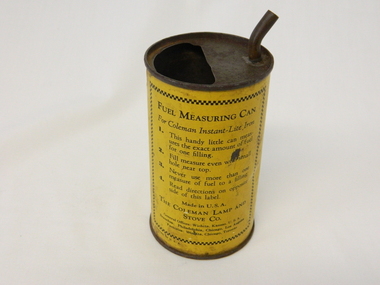
Can Fuel Measuring, circa 1950
The 1950's saw a revolution in small appliances for use in the average household. The hand held self heating(kerosene) iron for which this filling can was provided ,was introduced as a time saving and more convenient iron for pressing clothes and other cloth fabrics. It replaced irons needing an external fire source to heat the ironing plate. These irons continued to be in service, even when electricity was available in cities and larger rural towns. This item was used before and during the electricity supplies available from the Kiewa Hydro Electricity Scheme. These irons remained in use within regional rural areas that had limited or unreliable electrical reticulation and the ability to service them from this filling can was an essential part.n the 1950s and later the Kiewa Valley was still a relatively isolated region which was home to rural properties and small settlements. The availability of electricity and or the financial means to afford new types of electric hand irons ensured that older and sometimes less efficient ironing appliances remained for an extended period covering the 1960s to 1970s. Kerosene products, such as the kerosene self heating (KVHS 0347A) iron and this kerosene filling item, was a cheaper method for farm based domestic and other rural activities requiring a heat source. The use of kerosene as a heat/light source was able to be supplied in bulk and able to be used when floods severed vital roads into this region. The supply of electricity was in summer time subject to interruption from bush fire damaged wooden poles carrying the electrical cables. Self sufficiency by rural populations was the backbone of survival and the ability to store energy sources "on the farm" was a prerequisite of isolated regions, such as the Kiewa Valley, circa 1950s.This specially spout fitted can was provided with the Coleman self heating kerosene iron (see KVHS 0347A). On one side of the half enclosed top of the can there is a small spout(for poring the appropriate liquid into the egg shaped fount container) at the rear end of the hand iron. The can is made from tin. See KVHS 0347B- Instruction sheet; KVHS 0347C- Wrench.On one side of the can in black print on yellow background is "FUEL MEASURING CAN" underneath is "For Coleman Instant-Lite Iron" underneath are four numbered paragraphs detailing the use of this can. Below this is the name and places of manufacture. On the other side of the can is printed "BE SURE" with filling and maintenance instructionskerosene can, ironing, domestic appliances, household appliances -
 Kiewa Valley Historical Society
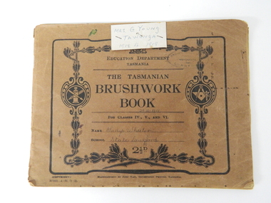
Book - Sketch Book, Circa 1918
This childhood sketchbook of the 1918 era details the emphasis placed upon a skill of brushwork that portrayed part of the students natural environment both in Tasmanian schools and Victorian schools, especially rural schools. The close bondage between students and their environment was a reflection on the early "hands on" approach in child education. Abstract art or teaching aids which could not be identified with physical properties available to students at this period in time were of lesser value. The ability of the student to identify the artistic value of local nature eg. local plants and flowers was especial important to rural based school children who had limited excursion opportunities available to visit town/city based botanical gardens and museums. This brushwork book is very significant to the Kiewa Valley as it demonstrates that childhood relocations from one State to another were not detrimental to the students overall scholastic development. The rural environment in Tasmania was not that far removed from the rural environment of the Kiewa Valley. The skills taught in both regions were still the same and the socio-economic factors and mores were also similar. This item demonstrates the relocation of one family from Tasmania to the Kiewa Valley. The expansion in population into the Kiewa valley was quite erratic and significant population growth only came after the increase in population brought into the area by the SEC Vic Hydro Scheme introduced to quench the demand for Victoria's electricity.This book has a brown cover with black print and designs on a 150 gsm cardboard. Each page is of the same thickness as the cover but is of paper.On the outside cover and contained within a thick boarder. "EDUCATION DEPARTMENT" and below this in smaller print "TASMANIA" below this "THE TASMANIAN BRUSHWORK BOOK". Below this "FOR CLASSES IV., V., AND VI" Below this "NAME" SCHOOL" At the bottom 2 1/2d1918's educational sketchbook, 1918 children's sketchbook -
 Warrnambool and District Historical Society Inc.
Document - Ledger, Leahy's Electrical Industries Committee, Circa mid 20th century
J. J. Leahy set up his retail electrical business in 1946 selling fridges, stoves and washers after commencing work wiring peoples’ homes in the late 1940’s. He developed the business into a large retail store and electrical contracting business which operated locally and Australia wide... He also ran Beattie and Phillips Funeral directors. The electrical business had several locations along Koroit Street before finally establishing on the south east corner of Fairy and Koroit Street. Jim died in November 26th 2008. The store is still run by his nephew Robert Askew. Jimmy Leahy was involved in the City council for a number of years and served as town mayor. The minutes contained in this book especially the information written in the Managing directors reports, provides an overview not just of a business but of business practice and the changes which occurred in life over the 40 year period. It contains events such as the introduction of television, refrigerated dairies and dates for tenders for major building programs such as WIAE, East Warrnambool School, Town Hall. Large dark blue fabric and leather bound ledger. The index pages are A –Z but contain no entries. Pages 1- 108 are handwritten minutes of Leahy’s Electrical Industries Committee. Pages 109-114 contain typed pages re AGM. Remaining pages are blank. Time period ranges from March 28th 1951 to December 1986. Signatures: J B Dwyer, W J Gleeson J J Leahy. Names included J.B. Dwyer, J.J. Leahy, M White, W.W. Croft, J.J. Walter, W Ross, J.J. Affleck, C.A. Richards, S J Wilson, J Croft, I.L. T Mahoney, P Conheady, J Meade.warrnambool, j.j. leahy, leahy’s, jimmy leahy, ledger, leahy’s electrical -
 Warrnambool and District Historical Society Inc.
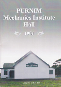
Booklet, Ron Best, Purnim Mechanics Institute Hall 1901, 2014
Brief history of Purnim Mechanics Institute HallThis is a paper back book of 24 pages. It has a white back cover and a grey/white front cover with a coloured photograph of the second Purnim Hall. The printed material is black on a white background. non-fictionBrief history of Purnim Mechanics Institute Hallpurnim, mechanics’ institutes, warrnambool -
Glen Eira Historical Society
Document - Memorials in Glen Eira
This file contains one item: 1/A printout from the Victorian Memorials Database, undated and researcher unknown, containing records of 9 memorials in the Caulfield City municipality. These memorials are: - Caulfield Grammar School Site Pavement Marker, Elsternwick - Monument to racehorse ‘Jackstaff’ in Caulfield Racing Museum. - Rosstown Railway Marker, Bambra Road, Caulfield. - Thomas Alexander Browne Grave, Brighton Cemetery. - Grave of Sir John and Lady Monash, Brighton Cemetery. - Frederick Jowett Memorial Drinking Fountain, Caulfield Town Hall - Adam Lindsay Gordon Grave, Brighton Cemetery. - Jewish victims of World War 2 Memorial, Kadimah Centre, Elsternwick. - Hopetown Gardens Cannon, Elsternwick.historical markers, caulfield city, caulfield grammar school, elsternwick, regent street, caulfield racing museum, rosstown railway marker, caulfield, bambra road, curraweena road, marara road, city of caulfield, mayors, councillors, caulfield historical society, rosstown railway, caulfield grammar school pavement marker, monument to racehorse ‘jackstaff’, ross murray, browne thomas alexander, thomas alexander browne grave, brighton cemetery, rolf boldrewood, north road, caulfield south, browne margaret maria, grave of sir john and lady monash, monash john sir, monash hannah victoria lady, frederick jowett memorial drinking fountain, caulfield town hall, hawthorn road, glen eira road, jowett frederick, borough of caulfield, adam lindsay gordon grave, gordon adam lindsay, gordon annie lindsay, jewish victims of world war 2 memorial, kadimah jewish cultural centre and library, selwyn street, burston seddon, hopetoun gardens cannon, glenhuntly road, glen huntly road, schools, historic sites, plaques, footpaths, horseracing, horses, jackstaff, monuments and memorials, railways, authors, cemeteries, graves, gravestones, jewish community, town clerks, shire secretaries, town hall, drinking taps, poetry, children, libraries, world war 1939 – 1945, hopetoun, cannons, festivals and celebrations