Showing 1193 items matching " city office"
-
 Ballarat Tramway Museum
Document - Photocopies, Alan Bradley, Extract SEC and BCC letters, Feb. 1995
Yields information about correspondence between the SEC and The City of Ballaarat during the period 1932 to 1945 and has a strong association with the research work of Alan Bradley.Eleven pages (Photocopies) of handwritten research notes, extracts of letters from SEC to the City of Ballarat (BCC) for period March 1932 to May 1945. From BCC records held at Ballarat Public Records Office, gives box numbers dates. Originals held by A. Bradley. Image of document added 19/10/2013trams, tramways, ballarat, city of ballarat, sec, tramways -
 Ballarat Tramway Museum
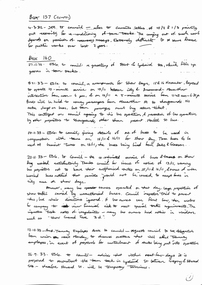
Map, Survey and Mapping for MMTB, "Map of Melbourne's Trams and Bus routes and all night services", Jan. 1967
Fold out sheet coloured map, 12 portions or folds, - title - "Map of Melbourne's Trams and Bus routes and all night services" map shows trams lines, route numbers, terminal points, bus routes, railway lines, blow up of city area with places of interest and key. On rear details, places of interest, suburb index, index to routes, first and last services, Sunday am services, all night bus services and locations of depots and head office. 2nd copy added 11-8-2006. Images of document - scanned to A3 size and overlapping added 30/10/13 On rear "out of date" stamp and 1 "cancelled" stamp - red ink.trams, tramways, melbourne, map, tram & bus services, all night services -
 Ballarat Tramway Museum
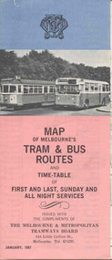
Slide - 35mm slide/s, 1968
Trams 12 and 21 as Myer's Christmas tram in City Loop. Photographed from south side of Sturt St. looking towards Post Office. Trams have both been fitted with lights, and have large white strip on front dash. Tram 21 has been made up as 'Santa's Showboat' and has red ensign flag on roof. Photo taken during the 1968 Christmas season. See Date advised by Alan Bradley, 15/3/03Niltramways, trams, santa tram, myers, decorated trams, city loop, tram 12, tram 21 -
 Kew Historical Society Inc
Plan, Melbourne & Metropolitan Board of Works : Borough of Kew : Detail Plan No.1576, 1904
The Melbourne and Metropolitan Board of Works (MMBW) plans were produced from the 1890s to the 1950s. They were crucial to the design and development of Melbourne's sewerage and drainage system. The plans, at a scale of 40 feet to 1 inch (1:480), provide a detailed historical record of Melbourne streetscapes and environmental features. Each plan covers one or two street blocks (roughly six streets), showing details of buildings, including garden layouts and ownership boundaries, and features such as laneways, drains, bridges, parks, municipal boundaries and other prominent landmarks as they existed at the time each plan was produced. (Source: State Library of Victoria)This plan forms part of a large group of MMBW plans and maps that was donated to the Society by the Mr Poulter, City Engineer of the City of Kew in 1989. Within this collection, thirty-five hand-coloured plans, backed with linen, are of statewide significance as they include annotations that provide details of construction materials used in buildings in the first decade of the 20th century as well as additional information about land ownership and usage. The copies in the Public Record Office Victoria and the State Library of Victoria are monochrome versions which do not denote building materials so that the maps in this collection are invaluable and unique tools for researchers and heritage consultants. A number of the plans are not held in the collection of the State Library of Victoria so they have the additional attribute of rarity.Original survey plan, issued by the MMBW to a contractor with responsibility for constructing sewers in the area identified on the plan within the Borough of Kew. The plan was at some stage hand-coloured, possibly by the contractor, but more likely by officers working in the Engineering Department of the Borough and later Town, then City of Kew. The hand-coloured sections of buildings on the plan were used to denote masonry or brick constructions (pink), weatherboard constructions (yellow), and public buildings (grey). Development in the 20th century has irreparably altered that part of Kew represented in this plan. In the block bounded by Cotham Road, Charles Street, Wellington Street and Gellibrand; just one house standing in 1903 remains. This block included two of the most historic houses in Kew: ‘Ordsall’ (later ‘Southesk’) and ‘Madford’ (previously ‘Elm Lodge’). Ordsall was the home of the second chairman of Kew, John Halfey. It contained some of the most significant interior murals in Kew, created for Halfey by artists working for Cullen & Co. It was demolished in 1960 to make way for the Kew Civic Centre. Elm Lodge had been built for William Siddeley in ca. 1864. Arthur Septimus King purchased it in 1874. The lower paddocks of Madford were sold in 1905 by his wife to the Borough of Kew and, after landscaping by George and Thomas Pockett, opened as the Alexandra Gardens in 1908. Elm Lodge/Madford was in 1922 to become St. Anthony’s Home for Little Children before its subsequent demolition in the 1980s.melbourne and metropolitan board of works, detail plans, maps - borough of kew, mmbw 1576, cartography -
 Kew Historical Society Inc
Plan, Borough of Kew Detail Plan No.1577, 1904
The Melbourne and Metropolitan Board of Works (MMBW) plans were produced from the 1890s to the 1950s. They were crucial to the design and development of Melbourne's sewerage and drainage system. The plans, at a scale of 40 feet to 1 inch (1:480), provide a detailed historical record of Melbourne streetscapes and environmental features. Each plan covers one or two street blocks (roughly six streets), showing details of buildings, including garden layouts and ownership boundaries, and features such as laneways, drains, bridges, parks, municipal boundaries and other prominent landmarks as they existed at the time each plan was produced. (Source: State Library of Victoria)This plan forms part of a large group of MMBW plans and maps that was donated to the Society by the Mr Poulter, City Engineer of the City of Kew in 1989. Within this collection, thirty-five hand-coloured plans, backed with linen, are of statewide significance as they include annotations that provide details of construction materials used in buildings in the first decade of the 20th century as well as additional information about land ownership and usage. The copies in the Public Record Office Victoria and the State Library of Victoria are monochrome versions which do not denote building materials so that the maps in this collection are invaluable and unique tools for researchers and heritage consultants. A number of the plans are not held in the collection of the State Library of Victoria so they have the additional attribute of rarity.Original survey plan, issued by the MMBW to a contractor with responsibility for constructing sewers in the area identified on the plan within the Borough of Kew. The plan was at some stage hand-coloured, possibly by the contractor, but more likely by officers working in the Engineering Department of the Borough and later Town, then City of Kew. The hand-coloured sections of buildings on the plan were used to denote masonry or brick constructions (pink), weatherboard constructions (yellow), and public buildings (grey). MMBW Plan No.1577 includes some of the most significant houses in Kew: Herbert Henty’s ‘Roxeth’ (now part of Trinity Grammar), ‘Butleigh Wooton’, ‘Bokara’ and ‘Harrow’. It also includes the streets that have since changed their names. That part of College Parade linked to Glenferrie Road is now named College Place, College Parade now extends further north, and Charles Street did not yet reach Barkers Road. Roxeth is one of a number of Henty houses in Kew. Herbert Henty made his home here and was elected a member of Kew Municipal Council in 1864 and mayor in 1868-69. Walter Henry Serle, of Harrow served in the First World War. He was awarded the Military Medal ‘’For conspicuous bravery and devotion to duty. On 29th September near BELLICOURT he showed the greatest bravery and determination when his platoon was attacked by enemy bombing parties. It was due largely to his personal efforts that all the attacks were repulsed. Until wounded, his utter disregard of personal safety and boldness in dealing with the attacks were the means of saving the situation and were an inspiring example to his men.’melbourne and metropolitan board of works, detail plans, maps - borough of kew, mmbw 1577, cartography -
 Kew Historical Society Inc
Plan, Melbourne & Metropolitan Board of Works : Borough of Kew : Detail Plan No.1578, 1904
The Melbourne and Metropolitan Board of Works (MMBW) plans were produced from the 1890s to the 1950s. They were crucial to the design and development of Melbourne's sewerage and drainage system. The plans, at a scale of 40 feet to 1 inch (1:480), provide a detailed historical record of Melbourne streetscapes and environmental features. Each plan covers one or two street blocks (roughly six streets), showing details of buildings, including garden layouts and ownership boundaries, and features such as laneways, drains, bridges, parks, municipal boundaries and other prominent landmarks as they existed at the time each plan was produced. (Source: State Library of Victoria). This plan forms part of a large group of MMBW plans and maps that was donated to the Society by the Mr Poulter, City Engineer of the City of Kew in 1989. Within this collection, thirty-five hand-coloured plans, backed with linen, are of statewide significance as they include annotations that provide details of construction materials used in buildings in the first decade of the 20th century as well as additional information about land ownership and usage. The copies in the Public Record Office Victoria and the State Library of Victoria are monochrome versions which do not denote building materials so that the maps in this collection are invaluable and unique tools for researchers and heritage consultants. A number of the plans are not held in the collection of the State Library of Victoria so they have the additional attribute of rarity.Original survey plan, issued by the MMBW to a contractor with responsibility for constructing sewers in the area identified on the plan within the Borough of Kew. The plan was at some stage hand-coloured, possibly by the contractor, but more likely by officers working in the Engineering Department of the Borough and later Town, then City of Kew. The hand-coloured sections of buildings on the plan were used to denote masonry or brick constructions (pink), weatherboard constructions (yellow), and public buildings (grey). MMBW Plan No.1578 is significant in that it defines the extent of two private schools: Xavier College and Kew High School (now part of Trinity Grammar) by 1904. In relation to the latter, the plan clarifies which buildings the High School operated from behind the mansion ‘Molina’. Established in 1902, Trinity Grammar was to later lease and subsequently buy Molina (now ‘Merritt House’) and ‘Elsinore’ (now ‘Roberts House’). Xavier College had been established in 1872. This 1904 plan delineates the West Wing and the Great Hall (built in 1890).melbourne and metropolitan board of works, detail plans, maps - borough of kew, mmbw 1578, cartography -
 Kew Historical Society Inc
Plan, Melbourne & Metropolitan Board of Works. Borough of Kew Detail Plan No.1579, 1904
The Melbourne and Metropolitan Board of Works (MMBW) plans were produced from the 1890s to the 1950s. They were crucial to the design and development of Melbourne's sewerage and drainage system. The plans, at a scale of 40 feet to 1 inch (1:480), provide a detailed historical record of Melbourne streetscapes and environmental features. Each plan covers one or two street blocks (roughly six streets), showing details of buildings, including garden layouts and ownership boundaries, and features such as laneways, drains, bridges, parks, municipal boundaries and other prominent landmarks as they existed at the time each plan was produced. (Source: State Library of Victoria). This plan forms part of a large group of MMBW plans and maps that was donated to the Society by the Mr Poulter, City Engineer of the City of Kew in 1989. Within this collection, thirty-five hand-coloured plans, backed with linen, are of statewide significance as they include annotations that provide details of construction materials used in buildings in the first decade of the 20th century as well as additional information about land ownership and usage. The copies in the Public Record Office Victoria and the State Library of Victoria are monochrome versions which do not denote building materials so that the maps in this collection are invaluable and unique tools for researchers and heritage consultants. A number of the plans are not held in the collection of the State Library of Victoria so they have the additional attribute of rarity.Original survey plan, issued by the MMBW to a contractor with responsibility for constructing sewers in the area identified on the plan within the Borough of Kew. The plan was at some stage hand-coloured, possibly by the contractor, but more likely by officers working in the Engineering Department of the Borough and later Town, then City of Kew. The hand-coloured sections of buildings on the plan were used to denote masonry or brick constructions (pink), weatherboard constructions (yellow), and public buildings (grey). While MMBW Plan No.1579 does not include many buildings, those that it does show are significant to Kew’s history. These include the ‘Kew [Railway] Station’ in Denmark Street and the ‘Recreation Hall’ and rear courts off Wellington Street. The plan shows the outline of the Recreation Hall, constructed in 1880, at the rear of which is listed a bowling green, two tennis courts, a ‘skittle alley’ and a pavilion. When the Hall was first built, the Kew Cricket Club occupied an adjacent ground, however in 1885 this was acquired by the State Government as the future location of the Kew Railway Station. The Plan also shows a single oval at Xavier College. This oval was completed in 1883. One of the current ovals conforms to this oval’s original shape and position in the school grounds.melbourne and metropolitan board of works, detail plans, maps - borough of kew, mmbw 1579, cartography -
 Kew Historical Society Inc
Plan, Melbourne and Metropolitan Board of Works, Borough of Kew : Detail Plan No.1580, 1904
The Melbourne and Metropolitan Board of Works (MMBW) plans were produced from the 1890s to the 1950s. They were crucial to the design and development of Melbourne's sewerage and drainage system. The plans, at a scale of 40 feet to 1 inch (1:480), provide a detailed historical record of Melbourne streetscapes and environmental features. Each plan covers one or two street blocks (roughly six streets), showing details of buildings, including garden layouts and ownership boundaries, and features such as laneways, drains, bridges, parks, municipal boundaries and other prominent landmarks as they existed at the time each plan was produced. (Source: State Library of Victoria)This plan forms part of a large group of MMBW plans and maps that was donated to the Society by the Mr Poulter, City Engineer of the City of Kew in 1989. Within this collection, thirty-five hand-coloured plans, backed with linen, are of statewide significance as they include annotations that provide details of construction materials used in buildings in the first decade of the 20th century as well as additional information about land ownership and usage. The copies in the Public Record Office Victoria and the State Library of Victoria are monochrome versions which do not denote building materials so that the maps in this collection are invaluable and unique tools for researchers and heritage consultants. A number of the plans are not held in the collection of the State Library of Victoria so they have the additional attribute of rarity.Original survey plan, issued by the MMBW to a contractor with responsibility for constructing sewers in the area identified on the plan within the Borough of Kew. The plan was at some stage hand-coloured, possibly by the contractor, but more likely by officers working in the Engineering Department of the Borough and later Town, then City of Kew. The hand-coloured sections of buildings on the plan were used to denote masonry or brick constructions (pink), weatherboard constructions (yellow), and public buildings (grey). The area represented in this detail plan has undergone significant change during the 20th century. The widening of High Street in the 1930s and 1950s involved the shops on the south side of High Street being demolished and later rebuilt to fit the widened street. Another significant loss was the mansion ‘Drayton’ fronting Wellington Street, owned at this stage by Susannah Fenton. Her family name would later to be given to Fenton Way, which was to be built over the grounds of the house following its demolition. The plan of the garden is particularly interesting, containing a batten dome fronting Wellington Street, an ornamental pond, a fountain and a brick and glass conservatory. The notes by the plumbing contractor on this plan are particularly detailed. Pink borders delineate the ownership of the varying parcels of land. Some of the better known owners listed include the real estate agent Cr. Henry de Castres Kellett (bt) and John Padbury, the funeral director. This particular plan provides a clear view of the configuration of the Kew Junction in 1903 and the commercial buildings that surrounded it.melbourne and metropolitan board of works, detail plans, maps - borough of kew, mmbw 1580, cartography -
 Kew Historical Society Inc
Plan, Melbourne & Metropolitan Board of Works : Borough of Kew : Detail Plan No.1581, 1904
The Melbourne and Metropolitan Board of Works (MMBW) plans were produced from the 1890s to the 1950s. They were crucial to the design and development of Melbourne's sewerage and drainage system. The plans, at a scale of 40 feet to 1 inch (1:480), provide a detailed historical record of Melbourne streetscapes and environmental features. Each plan covers one or two street blocks (roughly six streets), showing details of buildings, including garden layouts and ownership boundaries, and features such as laneways, drains, bridges, parks, municipal boundaries and other prominent landmarks as they existed at the time each plan was produced. (Source: State Library of Victoria)This plan forms part of a large group of MMBW plans and maps that was donated to the Society by the Mr Poulter, City Engineer of the City of Kew in 1989. Within this collection, thirty-five hand-coloured plans, backed with linen, are of statewide significance as they include annotations that provide details of construction materials used in buildings in the first decade of the 20th century as well as additional information about land ownership and usage. The copies in the Public Record Office Victoria and the State Library of Victoria are monochrome versions which do not denote building materials so that the maps in this collection are invaluable and unique tools for researchers and heritage consultants. A number of the plans are not held in the collection of the State Library of Victoria so they have the additional attribute of rarity.Original survey plan, issued by the MMBW to a contractor with responsibility for constructing sewers in the area identified on the plan within the Borough of Kew. The plan was at some stage hand-coloured, possibly by the contractor, but more likely by officers working in the Engineering Department of the Borough and later Town, then City of Kew. The hand-coloured sections of buildings on the plan were used to denote masonry or brick constructions (pink), weatherboard constructions (yellow), and public buildings (grey). The streets and built structures in this plan were surveyed in 1903 and released to contractors in 1904. In addition to the designation of building types by colour, the plan includes detailed descriptions of land use and ownership. While many buildings remain from this period, a number of the buildings represented have been demolished including the original Kew Town Hall, and the Congregational and Roman Catholic churches in Walpole Street. While the mansion ‘Illapa’ in Princess Street is still extant – now part of ‘Rylands’ – the neighbouring mansion ‘Elsmere’ was demolished some decades ago. Rivalling Illapa and Elsmere in size were two mansions in Walpole Street, one named on the plan as ‘Gnarlbine’. Over time, Kew Junction and the south side of High Street have been reconfigured and widened, so that the commercial buildings on the corner of Princess and High Street no longer exist. A surprising feature of this part of central Kew to the northwest of Kew Junction is the amount of vacant land. In a number of cases, this land is noted by the contractor as used for vegetable gardens.melbourne and metropolitan board of works, detail plans, maps - borough of kew, mmbw 1581, cartography -
 Kew Historical Society Inc
Plan, Melbourne & Metropolitan Board of Works : Borough of Kew : Detail Plan No.1582, 1904
The Melbourne and Metropolitan Board of Works (MMBW) plans were produced from the 1890s to the 1950s. They were crucial to the design and development of Melbourne's sewerage and drainage system. The plans, at a scale of 40 feet to 1 inch (1:480), provide a detailed historical record of Melbourne streetscapes and environmental features. Each plan covers one or two street blocks (roughly six streets), showing details of buildings, including garden layouts and ownership boundaries, and features such as laneways, drains, bridges, parks, municipal boundaries and other prominent landmarks as they existed at the time each plan was produced. (Source: State Library of Victoria)This plan forms part of a large group of MMBW plans and maps that was donated to the Society by the Mr Poulter, City Engineer of the City of Kew in 1989. Within this collection, thirty-five hand-coloured plans, backed with linen, are of statewide significance as they include annotations that provide details of construction materials used in buildings in the first decade of the 20th century as well as additional information about land ownership and usage. The copies in the Public Record Office Victoria and the State Library of Victoria are monochrome versions which do not denote building materials so that the maps in this collection are invaluable and unique tools for researchers and heritage consultants. A number of the plans are not held in the collection of the State Library of Victoria so they have the additional attribute of rarity.Original survey plan, issued by the MMBW to a contractor with responsibility for constructing sewers in the area identified on the plan within the Borough of Kew. The plan was at some stage hand-coloured, possibly by the contractor, but more likely by officers working in the Engineering Department of the Borough and later Town, then City of Kew. The hand-coloured sections of buildings on the plan were used to denote masonry or brick constructions (pink), weatherboard constructions (yellow), and public buildings (grey). Public buildings, coloured grey on the Plan 1582 include the police station and post office, churches and schools. The earliest church school, Common School No.356 was located at the rear of the Congregational Church in Peel Street. It was constructed in 1859. The first buildings of Kew Primary School No.1075 on the other side of Peel Street were constructed in 1871. The school in 1903 only occupied a small fraction of its current site. In 1903, where the rear playground is now located, were two weatherboard and one brick villa. Trinity Grammar School was founded in 1902 and opened in the Parish Hall at the rear of Holy Trinity Anglican Church. It was not to move to its current site until 1906. The outline of the building housing the Kew Fire Brigade in the centre of the north side of Walton Street is shown but not named on the plan. Further down Pakington Street stood the two-storey Italianate mansion ‘Overton’. The home of Stanford Chapman, it was to be featured in the Imperial Institute series of bromide photographs of Victoria, Vol. 1: Homes and scenery. It was later to become a boarding house before it was later demolished.melbourne and metropolitan board of works, detail plans, maps - borough of kew, mmbw 1582, cartography -
 Kew Historical Society Inc
Plan, Melbourne & Metropolitan Board of Works : Borough of Kew : Detail Plan No.1585, 1904
The Melbourne and Metropolitan Board of Works (MMBW) plans were produced from the 1890s to the 1950s. They were crucial to the design and development of Melbourne's sewerage and drainage system. The plans, at a scale of 40 feet to 1 inch (1:480), provide a detailed historical record of Melbourne streetscapes and environmental features. Each plan covers one or two street blocks (roughly six streets), showing details of buildings, including garden layouts and ownership boundaries, and features such as laneways, drains, bridges, parks, municipal boundaries and other prominent landmarks as they existed at the time each plan was produced. (Source: State Library of Victoria)This plan forms part of a large group of MMBW plans and maps that was donated to the Society by the Mr Poulter, City Engineer of the City of Kew in 1989. Within this collection, thirty-five hand-coloured plans, backed with linen, are of statewide significance as they include annotations that provide details of construction materials used in buildings in the first decade of the 20th century as well as additional information about land ownership and usage. The copies in the Public Record Office Victoria and the State Library of Victoria are monochrome versions which do not denote building materials so that the maps in this collection are invaluable and unique tools for researchers and heritage consultants. A number of the plans are not held in the collection of the State Library of Victoria so they have the additional attribute of rarity.Original survey plan, issued by the MMBW to a contractor with responsibility for constructing sewers in the area identified on the plan within the Borough of Kew. The plan was at some stage hand-coloured, possibly by the contractor, but more likely by officers working in the Engineering Department of the Borough and later Town, then City of Kew. The hand-coloured sections of buildings on the plan were used to denote masonry or brick constructions (pink), weatherboard constructions (yellow), and public buildings (grey). This plan, which covers parts of High Street, Pakington Street and Derby Street is dominated by two historic Kew mansions: ‘Konetta’ and ‘Ramornie’. Ramornie was constructed in 1890 for James Maitland Campbell, three times Mayor of Kew. Sold in 1940, it became a boarding house known as ‘The Towers’. Now a private residence again, it has only one of its three balconies remaining. The location of the missing two balconies can be seen on the plan. In 1903, the grounds of Ramornie included a large tennis court fronting Pakington Street. The rear of the property is shown as extending to Cobden Street. One of Kew’s oldest hotels, the Prospect Hill Hotel on the corner of High and Cobden Street was established in 1858. The outline of the hotel shown on the plan represents the second building on the site. During the 19th century it was often used for electoral meetings. The Prospect Hill Hotel was to be redeveloped again in 1928, by the local architect Robert McIntyre. Since the 1980s, the hotel has been a live music venue, the home of the Melbourne Jazz Club, a restaurant and a liquor outlet.melbourne and metropolitan board of works, detail plans, maps - borough of kew, mmbw 1585, cartography -
 Kew Historical Society Inc
Plan, Melbourne & Metropolitan Board of Works : Borough of Kew : Detail Plan No.1588, 1904
The Melbourne and Metropolitan Board of Works (MMBW) plans were produced from the 1890s to the 1950s. They were crucial to the design and development of Melbourne's sewerage and drainage system. The plans, at a scale of 40 feet to 1 inch (1:480), provide a detailed historical record of Melbourne streetscapes and environmental features. Each plan covers one or two street blocks (roughly six streets), showing details of buildings, including garden layouts and ownership boundaries, and features such as laneways, drains, bridges, parks, municipal boundaries and other prominent landmarks as they existed at the time each plan was produced. (Source: State Library of Victoria)This plan forms part of a large group of MMBW plans and maps that was donated to the Society by the Mr Poulter, City Engineer of the City of Kew in 1989. Within this collection, thirty-five hand-coloured plans, backed with linen, are of statewide significance as they include annotations that provide details of construction materials used in buildings in the first decade of the 20th century as well as additional information about land ownership and usage. The copies in the Public Record Office Victoria and the State Library of Victoria are monochrome versions which do not denote building materials so that the maps in this collection are invaluable and unique tools for researchers and heritage consultants. A number of the plans are not held in the collection of the State Library of Victoria so they have the additional attribute of rarity.Original survey plan, issued by the MMBW to a contractor with responsibility for constructing sewers in the area identified on the plan within the Borough of Kew. The plan was at some stage hand-coloured, possibly by the contractor, but more likely by officers working in the Engineering Department of the Borough and later Town, then City of Kew. The hand-coloured sections of buildings on the plan were used to denote masonry or brick constructions (pink), weatherboard constructions (yellow), and public buildings (grey). This plan shows the original configuration of the Kew Post Office, Court House and Police Station, which had opened in 1888. This configuration was to essentially remain until the purchase of the Court House and Police Station by the City of Boroondara in 2007 and its subsequent renovation. Interestingly, the MMBW surveyors incorrectly labelled parts of the complex. In the triangle in front of the Post Office, before the erection of the Kew Cenotaph in 1925, was located a lawn and the Queen Victoria Jubilee Fountain. While many of the shops on the south side of High street had been constructed by 1903 a number of sites were still used as vegetable gardens. Further along High Street, on the corner of Charles Street, the Salvation Army Barracks can be seen on the plan. These Barracks predate the later Citadel and ‘Young People’s Hall’ that were opened in 1919. At 22 Charles Street can be seen the house of James Venn Morgan. Hailed as the ‘father of Kew’, Morgan arrived in Melbourne in 1840. He was first engaged as a bookmaker, but a fortunate venture on the goldfields enabled him to purchase land in Kew. He conducted a market garden and dairy in Kew for many years.melbourne and metropolitan board of works, detail plans, maps - borough of kew, mmbw 1588, cartography -
 Kew Historical Society Inc
Plan, Melbourne & Metropolitan Board of Works : Borough of Kew : Detail Plan No.1590, 1905
The Melbourne and Metropolitan Board of Works (MMBW) plans were produced from the 1890s to the 1950s. They were crucial to the design and development of Melbourne's sewerage and drainage system. The plans, at a scale of 40 feet to 1 inch (1:480), provide a detailed historical record of Melbourne streetscapes and environmental features. Each plan covers one or two street blocks (roughly six streets), showing details of buildings, including garden layouts and ownership boundaries, and features such as laneways, drains, bridges, parks, municipal boundaries and other prominent landmarks as they existed at the time each plan was produced. (Source: State Library of Victoria)This plan forms part of a large group of MMBW plans and maps that was donated to the Society by the Mr Poulter, City Engineer of the City of Kew in 1989. Within this collection, thirty-five hand-coloured plans, backed with linen, are of statewide significance as they include annotations that provide details of construction materials used in buildings in the first decade of the 20th century as well as additional information about land ownership and usage. The copies in the Public Record Office Victoria and the State Library of Victoria are monochrome versions which do not denote building materials so that the maps in this collection are invaluable and unique tools for researchers and heritage consultants. A number of the plans are not held in the collection of the State Library of Victoria so they have the additional attribute of rarity.Original survey plan, issued by the MMBW to a contractor with responsibility for constructing sewers in the area identified on the plan within the Borough of Kew. The plan was at some stage hand-coloured, possibly by the contractor, but more likely by officers working in the Engineering Department of the Borough and later Town, then City of Kew. The hand-coloured sections of buildings on the plan were used to denote masonry or brick constructions (pink), weatherboard constructions (yellow), and public buildings (grey). Surveyed by the Board of Works in 1903 and published in 1904, Plan No.1590 shows development north of Cotham Road. While this plan includes built structures in Mary Street, Cotham Road, High Street, Park Hill Road, Kent Street, Ridgeway Avenue, and Ermington Lane (now Ermington Place), only part of this section was notated and coloured in this contractor’s copy. Numerous houses, large and small are named on the plan: ‘Cholula’, ‘Belper’, ‘The Uplands’, ‘Spring Grove’ facing Cotham Road; ‘Marion’ facing Kent Street; and ‘Kia Ora’ facing Ridgeway Avenue.melbourne and metropolitan board of works, detail plans, mmbw 1590, survey plans - borough of kew, cartography -
 Kew Historical Society Inc
Plan, Melbourne & Metropolitan Board of Works : Borough of Kew : Detail Plan No.1591, 1905
The Melbourne and Metropolitan Board of Works (MMBW) plans were produced from the 1890s to the 1950s. They were crucial to the design and development of Melbourne's sewerage and drainage system. The plans, at a scale of 40 feet to 1 inch (1:480), provide a detailed historical record of Melbourne streetscapes and environmental features. Each plan covers one or two street blocks (roughly six streets), showing details of buildings, including garden layouts and ownership boundaries, and features such as laneways, drains, bridges, parks, municipal boundaries and other prominent landmarks as they existed at the time each plan was produced. (Source: State Library of Victoria)This plan forms part of a large group of MMBW plans and maps that was donated to the Society by the Mr Poulter, City Engineer of the City of Kew in 1989. Within this collection, thirty-five hand-coloured plans, backed with linen, are of statewide significance as they include annotations that provide details of construction materials used in buildings in the first decade of the 20th century as well as additional information about land ownership and usage. The copies in the Public Record Office Victoria and the State Library of Victoria are monochrome versions which do not denote building materials so that the maps in this collection are invaluable and unique tools for researchers and heritage consultants. A number of the plans are not held in the collection of the State Library of Victoria so they have the additional attribute of rarity.Original survey plan, issued by the MMBW to a contractor with responsibility for constructing sewers in the area identified on the plan within the Borough of Kew. The plan was at some stage hand-coloured, possibly by the contractor, but more likely by officers working in the Engineering Department of the Borough and later Town, then City of Kew. The hand-coloured sections of buildings on the plan were used to denote masonry or brick constructions (pink), weatherboard constructions (yellow), and public buildings (grey). That area of Kew bordered by Cotham Road, Park Hill Road, Ermington Lane (now Ermington Place), and Belmont Avenue contained some of the significant homes owned by Kew pioneers. Chief among these was ‘Park Hill’ on an enormous lot facing Park Hill Road. The Jubilee History of 1910 noted, six years after this plan was drawn, that: ‘Park Hill Road, forming the southern boundary of the cemetery, takes its name from Park Hill, the residence of Mr. Thomas Judd, who has resided there since December, 1852.’ Other named houses on the plan include ‘Ferndale’ facing Cotham Road; ‘Ermington’ adjacent to Judd’s Park Hill, facing Park Hill Road; and ‘Gilden’ and ‘Mont Belmont’ facing Belmont Avenue. Mont Belmont was designed by the architectural firm of Reed, Henderson and Smart for William George Lilley in 1887 and was completed in 1888. Lilley was Mayor of Kew in 1887-88, a Justice of the Peace and a member of the first Board of Guardians of Kew’s St. Hilary’s Church of England.melbourne and metropolitan board of works, detail plans, survey plans - borough of kew, mmbw 1591, cartography -
 Kew Historical Society Inc
Plan, Melbourne & Metropolitan Board of Works : Borough of Kew : Detail Plan No.1592, 1905
The Melbourne and Metropolitan Board of Works (MMBW) plans were produced from the 1890s to the 1950s. They were crucial to the design and development of Melbourne's sewerage and drainage system. The plans, at a scale of 40 feet to 1 inch (1:480), provide a detailed historical record of Melbourne streetscapes and environmental features. Each plan covers one or two street blocks (roughly six streets), showing details of buildings, including garden layouts and ownership boundaries, and features such as laneways, drains, bridges, parks, municipal boundaries and other prominent landmarks as they existed at the time each plan was produced. (Source: State Library of Victoria). This plan forms part of a large group of MMBW plans and maps that was donated to the Society by the Mr Poulter, City Engineer of the City of Kew in 1989. Within this collection, thirty-five hand-coloured plans, backed with linen, are of statewide significance as they include annotations that provide details of construction materials used in buildings in the first decade of the 20th century as well as additional information about land ownership and usage. The copies in the Public Record Office Victoria and the State Library of Victoria are monochrome versions which do not denote building materials so that the maps in this collection are invaluable and unique tools for researchers and heritage consultants. A number of the plans are not held in the collection of the State Library of Victoria so they have the additional attribute of rarity.Original survey plan, issued by the MMBW to a contractor with responsibility for constructing sewers in the area identified on the plan within the Borough of Kew. The plan was at some stage hand-coloured, possibly by the contractor, but more likely by officers working in the Engineering Department of the Borough and later Town, then City of Kew. The hand-coloured sections of buildings on the plan were used to denote masonry or brick constructions (pink), weatherboard constructions (yellow), and public buildings (grey). In MMBW Plan No.1592, the pink line indicates that area of the plan for which the contracting engineer was responsible. Included in the Plan are a number of primarily brick villas in a section of Belmont Avenue off Cotham Road. The house ‘Uvadale’ north of Belmont Avenue, and facing Cotham Road is also included in the contract. Excluded from the contract but shown on the Plan are ‘Glendonald’, ‘Mont Belmont’ and ‘Gilden’.melbourne and metropolitan board of works, detail plans, survey plans - borough of kew, mmbw 1592, cartography -
 Kew Historical Society Inc
Plan, Melbourne & Metropolitan Board of Works / Borough of Kew, Detail Plan No.1593, 1905
The Melbourne and Metropolitan Board of Works (MMBW) plans were produced from the 1890s to the 1950s. They were crucial to the design and development of Melbourne's sewerage and drainage system. The plans, at a scale of 40 feet to 1 inch (1:480), provide a detailed historical record of Melbourne streetscapes and environmental features. Each plan covers one or two street blocks (roughly six streets), showing details of buildings, including garden layouts and ownership boundaries, and features such as laneways, drains, bridges, parks, municipal boundaries and other prominent landmarks as they existed at the time each plan was produced. (Source: State Library of Victoria)This plan forms part of a large group of MMBW plans and maps that was donated to the Society by the Mr Poulter, City Engineer of the City of Kew in 1989. Within this collection, thirty-five hand-coloured plans, backed with linen, are of statewide significance as they include annotations that provide details of construction materials used in buildings in the first decade of the 20th century as well as additional information about land ownership and usage. The copies in the Public Record Office Victoria and the State Library of Victoria are monochrome versions which do not denote building materials so that the maps in this collection are invaluable and unique tools for researchers and heritage consultants. A number of the plans are not held in the collection of the State Library of Victoria so they have the additional attribute of rarity.Original survey plan, issued by the MMBW to a contractor with responsibility for constructing sewers in the area identified on the plan within the Borough of Kew. The plan was at some stage hand-coloured, possibly by the contractor, but more likely by officers working in the Engineering Department of the Borough and later Town, then City of Kew. The hand-coloured sections of buildings on the plan were used to denote masonry or brick constructions (pink), weatherboard constructions (yellow), and public buildings (grey). The laborious task of hand-tinting these Board of Works plans was not without hazards as is evidenced by Plan No. 1593. On the Plan, the original colourist spilt black and green ink, partially obscuring some parts. The most obvious casualty is ‘Clifton’ located on the corner of Cotham Road and Park Street [now Adeney Avenue]. Included in this Plan, and outlined in pink is that part of the section that the contracting engineer was tasked with completing. This included sewering on both sides of this part of Cotham Road, but excluded properties such as ‘Glendonald’ and ‘Monnington’. This area was to undergo a series of subdivisions including the ‘Clifton Estate’, which created housing lots on Adeney Avenue and Florence Avenue in 1916. The most notable occupant of Clifton was William Adeney [died 1893], a pioneer of Camperdown, after which Park Street was later renamed.melbourne and metropolitan board of works, detail plans, survey plans - borough of kew, mmbw 1593, cartography -
 Kew Historical Society Inc
Plan, Melbourne & Metropolitan Board of Works : Contour Plan of Melbourne & Suburbs : Melbourne Sewage, 1894
The Melbourne and Metropolitan Board of Works (MMBW) plans were produced from the 1890s to the 1950s. They were crucial to the design and development of Melbourne's sewerage and drainage system. This plan forms part of a large group of MMBW plans and maps that was donated to the Society by the Mr Poulter, City Engineer of the City of Kew in 1989. Within this collection, thirty-five hand-coloured plans, backed with linen, are of statewide significance as they include annotations that provide details of construction materials used in buildings in the first decade of the 20th century as well as additional information about land ownership and usage. The copies in the Public Record Office Victoria and the State Library of Victoria are monochrome versions which do not denote building materials so that the maps in this collection are invaluable and unique tools for researchers and heritage consultants. A number of the plans are not held in the collection of the State Library of Victoria so they have the additional attribute of rarity.Digital copy of an original MMBW plan. This contour plan shows the area identified by the MMBW for purposes of drainage and sewerage in 1894. The suburbs represented extend from Williamstown in the west to Bulleen in the east, and from Preston in the north, south to Sandringham. Suburbs are outlined in coloured ink. Red lines indicate main and branch sewers in existence at the beginning of 1894 in central and inner Melbourne. These extended as far as Williamstown and Brighton, but not yet as far as Kew, where sewering did not commence until 1901. Contour lines show the topography, which was important for indicating the fall of the land for the laying of sewers and drainage channels. Kew appears to be fairly undeveloped at this date except for railway lines and stations (the Kew and Outer Circle lines), main roads, the Kew Lunatic Asylum Reserve and Studley Park. However, the contour plan does not accurately represent the density of settlement, nor the large number of houses, which were being built in Kew and other suburbs from the 1850s to the land boom of the late 1880’s and early 1890’s. This plan is part of a large and historically significant group of MMBW plans and maps that was donated to the Society by the Mr Poulter, City Engineer of the City of Kew in 1989.mmbw contour plan of melbourne and suburbs, melbourne and metropolitan board of works, melbourne sewage, cartography -
 Kew Historical Society Inc
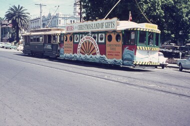
Certificate, Melbourne Tramways Trust, Framed Testimonial to Alderman Thomas O'Grady J.P. from the Melbourne Tramways Trust, 5 February 1886
The recipient of the testimonial, Thomas O’Grady (1824-90) had migrated to Melbourne in 1854, practising the trades of building and contracting. The Australian Dictionary of Biography records that he became a Councillor of the City of Melbourne in 1868. It lists one of his major achievements as the construction ‘with Leggett & Noonan [of] the fifty-six-mile (90 km) railway from Essendon to Seymour’. He was chairman of the Tramways Trust from its formation in 1884. His obituary in the Melbourne Herald (29 Apr 1890) reported: "DEATH OF ALDERMAN THOMAS O'GRADY. Today we have the sad duty of recording the death of two old colonists, who for many years, havo occupied very, prominent positions in building, commercial and municipal circles. The first of these is Alderman Thomas O'Grady, who died last night at his residence in Carlton. Mr O'Grady has been ill for some time, and at one period his death was expected any moment. Then he rallied, and strong hopes of his recovery were entertained; but he had a relapse, and expired as stated. The deceased gentleman was one of the oldest members of the City Council, in which he has held the various positions of Councillor, Alderman and Mayor. At the time of his death he sat as alderman for Victoria Ward. Mr O'Grady also at one time represented the City Council on the Harbor Trust, and was chairman of that body. He has been the council's representative on the Tramway Trust and was chairman of that body for some considerable time." As late as 1951, the Advocate (11 Oct 1951) stated that: "To Alderman Thomas O'Grady, Lord Mayor of Melbourne in 1872-3, is due the credit of the successful inauguration of Hospital Sunday. Alderman O'Grady was the first Catholic Lord Mayor of the city. He was elected a councillor for Smith Ward in 1868, and an alderman in 1869. In private life he was an extensive contractor, being a member of the firm of O'Grady, Leggett and Noonan, the contractors for the first section of the Northeastern Railways (between Melbourne and Seymour)."This is a unique civic document, illustrating the life and contribution of Thomas O’Grady (1824-90), Melbourne City Councillor and first Chairman of the Melbourne Tramways Trust. It is historically significant in its recording of the development of Melbourne's public transport system. The design of the certificate and particularly the ebonised frame are artistically and aesthetically significant.An illustrated testimonial presented to the first Chairman of the Melbourne Tramways Trust in 1886. The Testimonial is encased in an ebonized frame of the period. It includes the coat-of-arms of 12 cities, corporations, boroughs and towns, including that of Kew. At the head of the testimonial the engines used to drive the cable systems are illustrated. At the foot of the testimonial there is a picture of two cable trams.The testimonial reads: ‘At the meeting of the Melbourne Tramways Trust held on the Fifth Day of February 1886, the following resolution was unanimously carried. That the thanks of the Melbourne Tramways Trust are due and are hereby accorded to Alderman Thomas O’Grady Hon. JP, the first Chairman of the Trust for the ability, courtesy and impartiality with which he has discharged his duties during the past two years, and the Trust heartily congratulates him on the successful opening during his term of office of the Richmond Tramway (the first Cable line constructed in Australia) and tenders him its earnest wishes for his future prosperity and welfare.’ melbourne tramways trust, thomas o’grady (1824-90), cable trams, lord mayors of melbourne -
 Kew Historical Society Inc
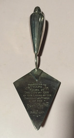
Ceremonial object, Unknown, Commemorative Trowel in Presentation Box, 1971, 1982
WADE, Ivan Mayor 1969-70, 1970-71 Ivan Wade grew up in Bendigo and Brunswick, one of eight children. After his marriage, he moved with his wife and young family to Kew in 1951. In 1959, he took a year’s sabbatical in 1959 to build a new family home for his wife and four children at 222 Cotham Road, Kew. He worked professionally in the Meat Industry, successfully building a small chain of retail butcher shops, and a meat exporting business. He worked for improvements in the Trade through involvement in the Meat and Allied Trades Federation, of which he was the first State, and then Federal President. He was to be awarded an OBE for his services to the Meat Industry in 1979. Having been a long-time member of Melbourne Lions Club, he helped start Chadstone Lions’ Club as an inaugural tenant of the Chadstone Shopping Centre in 1979. He was also a tireless worker for charity, making his home available for functions raising funds for local groups. His passion for the community led him to stand for Kew Council as a representative of College Ward. As a councillor, he was elected mayor for two terms. During his term of office, new Kew Municipal Offices were constructed in Cotham Road. An active worker for the Kew Elder Citizens Association, he was involved in the establishment of an Opportunity Shop in Walpole Street to raise funds for the development of a new Centre in High Street. The Opportunity Shop was used to train locally unemployed youth skills such as furniture repair. (GW)Silver presentation trowel associated with the opening of significant civic projects in the former City of Kew.Commemorative, inscribed silver-plated presentation trowel given by the City of Kew to the Mayor, Cr Ivan Wade, on the occasion of the laying of the foundation stone of the new Kew Civic Centre on the corner of Cotham Road and Charles Street, now part of Trinity Grammar School. The silver trowel was presented in a black leather case lined with blue velvet. The trowel was to be used a second time in 1982 when Cr Wade and his wife laid the foundation stone of Hamer Court. The trowel was later donated to Kew Historical Society Inc by Gwlad Wade, the wife of Cr Ivan Wade, on 20 August 2000. Front: "Presented to Cr Wade J.P. / Mayor of / the City of Kew / at the laying of the / foundation stone / of the / Kew Civic Centre /20-8-1971." Reverse: This trowel was also used / by / Cr Ivan Wade OBE JP & Mrs Gwlad Wade / at the laying / of the foundation stone / of / "Hamer Court" / Hostel for the Aged / 22nd August 1982"cr ivan wade, hamer court, commemorative trowels, kew civic offices, city of kew 1860-1993 -
 Kew Historical Society Inc
Archive (Sub-series) - Subject File, Kew Historical Society, Kew Association of Boroondara Inc, 1994
Various partiesReference, Research, InformationSecondary Values (KHS Imposed Order)This subject file contains information about the second Kew Association, formed in 1994 to ensure that residents of Kew were adequately represented in the new amalgamated City of Boroondara. In 2000, the group mounted a case [unsuccessfully] for Kew to secede from the new City. The Discussion Paper for Secession is included in the file. The latest reference to the Association is a newspaper article form 2004. The file mainly contains proposals, agendas and minutes of meetings, and the Association’s Constitution. Many of its office bearers were active in other community groups.kew - history, kew association - kew (vic), kew association of boroondara inc, local government restructure - kew (vic)kew - history, kew association - kew (vic), kew association of boroondara inc, local government restructure - kew (vic) -
Kew Historical Society Inc
Archive (Sub-series) - Subject File, Kew Court House 1986-1989, 1986
Various partiesReference, Research, InformationSecondary Values (KHS Imposed Order)Subject file containing information relating to the Kew Post Office complex, including the Kew Court House and the Police Station. The correspondence between parties included the City of Kew, the Kew Historical Society, and the Victorian Government. Initially the correspondence related to the proposed use of the Court House as a Centre for the Society as it was being forced to vacate the Copy Shop (q.v) in Walpole Street due to its impending demolition. Later correspondence relates to the proposed sale of the Court House by the Victorian Government.kew - history, kew court house, kew police station, heritage campaigns - kew (vic)kew - history, kew court house, kew police station, heritage campaigns - kew (vic) -
Kew Historical Society Inc
Archive (Sub-series) - Subject File, Community Centre (Kew), 1958
Various partiesReference, Research, InformationSecondary Values (KHS Imposed Order)Subject file containing correspondence between office-bearers of the Kew Historical Society and the City of Kew relating to the possibility of purchasing historic buildings from demolition and for use as a community centre and historical society premises or museum. Properties discussed included 14/16 Princess Street and the hall (Neama) on the site of St Paul’s School.community centres -- kew (vic), historical museums - proposedcommunity centres -- kew (vic), historical museums - proposed -
 Kew Historical Society Inc
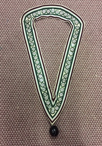
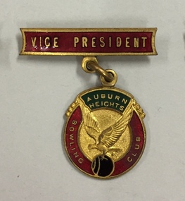
Ceremonial object - President's Collar, Kew Bowling Club, 1970-1998
Sports Clubs in Kew in the final decades of the 19th century and in the early 20th century were often umbrella organisations with facilities for a number of sports. Typically in Kew, this included teams in lawn bowls, tennis and croquet. The Kew Bowling Club was formed in 1880 while the privately owned Auburn Heights Recreation Club was opened in 1904. By 1998, the two Clubs decided to amalgamate at the Auburn Heights site in Barkers Road, forming the Kew Heights Sports Club. The combined club was itself taken over by the Melbourne Cricket Club in 2012 becoming MCC Kew Sports Club. In 2017 MCC Kew closed and its landholding was subsequently sold to Carey Baptist Grammar School. Both the Kew and Auburn Heights Clubs assembled important collections. These historically significant and large collections were donated to the Society in 2020. The collections include manuscripts, pictures, trophies, plans, honour boards etc. References Barnard FGA 1910, 'Sports and Pastimes' in Jubilee History of Kew Victoria: Its origin & progress 1803-1910. Nixon NV 1980, The History of the Kew Bowling Club 1880-1980. Reeve S 2012, City of Boroondara: Thematic Environmental History, p.216.The combined collections of the four sporting clubs making up the collection number hundreds of items that are historically significant locally. They are also significant to the sporting history of the greater Melbourne area and to the sports of lawn bowls and tennis in Australia in the 19th and 20th centuries. The collection illuminates two of the Victorian historic themes - 'Building community life' through forming community organisations and 'Shaping cultural and creative life' by participating in sport and recreation.President's Collar used as an insignia of office, comprised of a fabric band in the colours of the Kew Bowling Club, covered with club badges and with a decorative bowling ball attached. [The item is part of the large historic Kew Bowling Club collection (1880-1988) gifted to the Kew Historical Society in 2020].kew bowling club - wellington street - kew (vic), clubs - lawn bowls - kew (vic), insignia of office -
 Kew Historical Society Inc
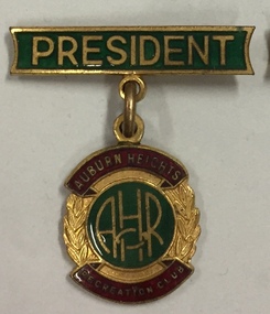
Badge - Badge of Office, President Auburn Heights Recreation Club, 1980-1990
Sports Clubs in Kew in the final decades of the 19th century and in the early 20th century were often umbrella organisations with facilities for a number of sports. Typically in Kew, this included teams in lawn bowls, tennis and croquet. The Kew Bowling Club was formed in 1880 while the privately owned Auburn Heights Recreation Club was opened in 1904. By 1998, the two Clubs decided to amalgamate at the Auburn Heights site in Barkers Road, forming the Kew Heights Sports Club. The combined club was itself taken over by the Melbourne Cricket Club in 2012 becoming MCC Kew Sports Club. In 2017 MCC Kew closed and its landholding was subsequently sold to Carey Baptist Grammar School. Both the Kew and Auburn Heights Clubs assembled important collections. These historically significant and large collections were donated to the Society in 2020. The collections include manuscripts, pictures, trophies, plans, honour boards etc. References Barnard FGA 1910, 'Sports and Pastimes' in Jubilee History of Kew Victoria: Its origin & progress 1803-1910. Chapman J & C 1999, The history of the Auburn Heights Recreation Club, 1904 to 1908. Reeve S 2012, City of Boroondara: Thematic Environmental History, p.216.The combined collections of the four sporting clubs making up the collection number hundreds of items that are historically significant locally. They are also significant to the sporting history of the greater Melbourne area and to the sports of lawn bowls and tennis in Australia in the 19th and 20th centuries. The collection illuminates two of the Victorian historic themes - 'Building community life' through forming community organisations and 'Shaping cultural and creative life' by participating in sport and recreation.Gilt and enamel badge worn by of the president of the Auburn Heights Recreation Club. auburne heights recreation club - barkers road - kew (vic), badges of office -
 Kew Historical Society Inc
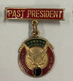
Badge - Badge of Office, Past-President Auburn Heights Bowling Club, 1970-1980
Sports Clubs in Kew in the final decades of the 19th century and in the early 20th century were often umbrella organisations with facilities for a number of sports. Typically in Kew, this included teams in lawn bowls, tennis and croquet. The Kew Bowling Club was formed in 1880 while the privately owned Auburn Heights Recreation Club was opened in 1904. By 1998, the two Clubs decided to amalgamate at the Auburn Heights site in Barkers Road, forming the Kew Heights Sports Club. The combined club was itself taken over by the Melbourne Cricket Club in 2012 becoming MCC Kew Sports Club. In 2017 MCC Kew closed and its landholding was subsequently sold to Carey Baptist Grammar School. Both the Kew and Auburn Heights Clubs assembled important collections. These historically significant and large collections were donated to the Society in 2020. The collections include manuscripts, pictures, trophies, plans, honour boards etc. References Barnard FGA 1910, 'Sports and Pastimes' in Jubilee History of Kew Victoria: Its origin & progress 1803-1910. Chapman J & C 1999, The history of the Auburn Heights Recreation Club, 1904 to 1908. Reeve S 2012, City of Boroondara: Thematic Environmental History, p.216.The combined collections of the four sporting clubs making up the collection number hundreds of items that are historically significant locally. They are also significant to the sporting history of the greater Melbourne area and to the sports of lawn bowls and tennis in Australia in the 19th and 20th centuries. The collection illuminates two of the Victorian historic themes - 'Building community life' through forming community organisations and 'Shaping cultural and creative life' by participating in sport and recreation.One of five metal and enamel medallions, labelled singly AHRC President, AHBC Past President, AHBC Vice President, AHBC Secretary, AHRC Life Member; and AHRC tiepin.auburne heights recreation club - barkers road - kew (vic), badges of office -
 Kew Historical Society Inc
Badge - Badge of Office, Vice-President Auburn Heights Bowling Club, 1980-1990
Sports Clubs in Kew in the final decades of the 19th century and in the early 20th century were often umbrella organisations with facilities for a number of sports. Typically in Kew, this included teams in lawn bowls, tennis and croquet. The Kew Bowling Club was formed in 1880 while the privately owned Auburn Heights Recreation Club was opened in 1904. By 1998, the two Clubs decided to amalgamate at the Auburn Heights site in Barkers Road, forming the Kew Heights Sports Club. The combined club was itself taken over by the Melbourne Cricket Club in 2012 becoming MCC Kew Sports Club. In 2017 MCC Kew closed and its landholding was subsequently sold to Carey Baptist Grammar School. Both the Kew and Auburn Heights Clubs assembled important collections. These historically significant and large collections were donated to the Society in 2020. The collections include manuscripts, pictures, trophies, plans, honour boards etc. References Barnard FGA 1910, 'Sports and Pastimes' in Jubilee History of Kew Victoria: Its origin & progress 1803-1910. Chapman J & C 1999, The history of the Auburn Heights Recreation Club, 1904 to 1908. Reeve S 2012, City of Boroondara: Thematic Environmental History, p.216.The combined collections of the four sporting clubs making up the collection number hundreds of items that are historically significant locally. They are also significant to the sporting history of the greater Melbourne area and to the sports of lawn bowls and tennis in Australia in the 19th and 20th centuries. The collection illuminates two of the Victorian historic themes - 'Building community life' through forming community organisations and 'Shaping cultural and creative life' by participating in sport and recreation.One of five metal and enamel medallions, labelled singly AHRC President, AHBC Past President, AHBC Vice President, AHBC Secretary, AHRC Life Member; and AHRC tiepin.auburne heights recreation club - barkers road - kew (vic), badges of office -
 Kew Historical Society Inc
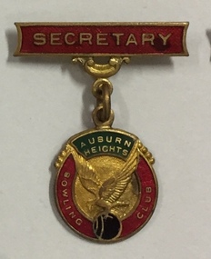
Badge - Badge of Office, Secretary Auburn Heights Bowling Club, 1980-1990
Sports Clubs in Kew in the final decades of the 19th century and in the early 20th century were often umbrella organisations with facilities for a number of sports. Typically in Kew, this included teams in lawn bowls, tennis and croquet. The Kew Bowling Club was formed in 1880 while the privately owned Auburn Heights Recreation Club was opened in 1904. By 1998, the two Clubs decided to amalgamate at the Auburn Heights site in Barkers Road, forming the Kew Heights Sports Club. The combined club was itself taken over by the Melbourne Cricket Club in 2012 becoming MCC Kew Sports Club. In 2017 MCC Kew closed and its landholding was subsequently sold to Carey Baptist Grammar School. Both the Kew and Auburn Heights Clubs assembled important collections. These historically significant and large collections were donated to the Society in 2020. The collections include manuscripts, pictures, trophies, plans, honour boards etc. References Barnard FGA 1910, 'Sports and Pastimes' in Jubilee History of Kew Victoria: Its origin & progress 1803-1910. Chapman J & C 1999, The history of the Auburn Heights Recreation Club, 1904 to 1908. Reeve S 2012, City of Boroondara: Thematic Environmental History, p.216.The combined collections of the four sporting clubs making up the collection number hundreds of items that are historically significant locally. They are also significant to the sporting history of the greater Melbourne area and to the sports of lawn bowls and tennis in Australia in the 19th and 20th centuries. The collection illuminates two of the Victorian historic themes - 'Building community life' through forming community organisations and 'Shaping cultural and creative life' by participating in sport and recreation.One of five metal and enamel medallions, labelled singly AHRC President, AHBC Past President, AHBC Vice President, AHBC Secretary, AHRC Life Member; and AHRC tiepin.AHBC / SECRETARYauburne heights recreation club - barkers road - kew (vic), badges of office -
 Kew Historical Society Inc
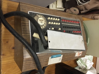
Equipment, City of Kew Switchboard, 1960s
... equipment - a switchboard - in the City's civic offices. office ...The local government area of Kew was established in 1860. Through successive incarnations as a municipality, borough, town and city, its headquarters, at least until 1972, were located in a town hall in Walpole Street. In 1994, the city was amalgamated into a new City of Boroondara. This items served as telephone equipment - a switchboard - in the City's civic offices.Switchboard used in the City of Kew's Civic Offices in Walpole Street. The redundant equipment was donated to the Society in 1988.office equipment, city of kew, switchboards -
 Kew Historical Society Inc
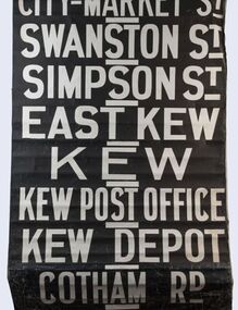
Functional object - Destination Roll, Melbourne & Metropolitan Tramways Board, 1960s
In an era predating the computerisation of equipment on public transport, where trams in Melbourne were driven by drivers and conductors sold fares, destinations were shown at the front and rear of the tram within a glazed box. A driver adjusted the roll to select each new trip destination. Given the length of rolls, in this case approximately nine metres, this could be a time consuming process. In addition to the named destination roll, each tram included a separate roll listing the route numbers.The roll was purchased at a Leski Auction in Armadale as part of a large group of tramways memorabilia including tram 'rolls' from New South Wales, Victoria, South Australia and Tasmania. The auction house described the collection as "The collection of destination blinds or rolls that forms the core of the Railways Trams & Buses Section (Lots 655 – 732) is the best we have ever offered and represents a life-time of collecting by an Adelaide enthusiast, now deceased." Melbourne & Metropolitan Tramways Board Tramways Destination Roll. Black and white paint on linen roll. Forty-eight named destinations including four depots - Camberwell, Hanna Street, Hawthorn, Kew. Multiple destinations in what is now the City of Boroondara (Kew, Hawthorn and Camberwell); including East Kew, Kew, Kew Post Office, Kew Depot, and Cotham Road.Named destinations beginning to end: “Olympic Park / Special / Football / Racecourse / Richmond / Burnley / Riversdale / Wattle Park - Warragul Rd / Wattle Park - Elgar Rd / City / Burwood / Hartwell / Bowen St / Camberwell Depot / Camberwell Jucn / Leura Grove / Gardener / Glenferrie Rd / Chapel St / St Kilda Rd / Camberwell / City / Lonsdale St / University / City via William St / Domain Rd / Hanna St Depot / South Melb & St Kilda Beach / Prahran / North Richmond / Windsor / Hawthorn Depot / Hawthorn / Spencer St / Toorak Rd / Swan & Church St Cnr / North Balwyn / City Flinders & Spencer Sts Corner / City - Market St / Swanston St / Simpson St / East Kew / Kew / Kew Post Office / Kew Depot / Cotham Rd / Malv Tn Hall"melbourne & metropolitan tramways board -
Kew Historical Society Inc
Journal, Kewriosity : July 1992
City of Kew Ward boundaries [map] / p1. Council election Saturday 1st August, 1992 Prospect Ward / p1. Letter from resident 'waste management' / Katrine Keuneman p2. Kew Junction Commercial Centre Precinct 8 / p2. Kew and Hawthorn a place for cyclists / p2. Mayor's Comment / Cr Daryl Oldaker p3. Come rain, hail or sunshine [school crossings] / p3 Kew Lioness Club / p3. Diary Dates for July/August pp.4-5. In Brief [Sold Kew Post Office; Help your postie deliver your mail; Carnsworth Nursing Home volunteers] / p4. In Brief continued [Kew Bowling Club; The Asthma Foundation of Victoria; Work at home as a family day caregiver; Kew Band; Kew Senior Citizens: Lions Club Opportunity Shop] / p5. My feelings on Kew / Chris Howlett p6. Youth homelessness / p6. Kew Festival / p6. Victorian Disabled Skiers' Assoc./ p7. Midwifery commemoration / p7. Vaccination against Haemophilus Influenzae Type B Disease / p7. Quit Quiz / p7. Our [Four Seasons] window [by Alan Sumner, in Kew Library] / p7. Pictures of Kew Kew High School students; Dedication of Burke Hall oval to past Mayor of Kew, the late Jack Gervasoni; Volunteers Reception; Bryan Berry] p8.Kewriosity was a local newsletter combining Kew Council and community news. It was published between November 1983 and June 1994, replacing an earlier Kewriosity [broad] Sheet (1979-84). In producing Kewriosity, Council aimed to provide a range of interesting and informative articles covering its deliberations and decision making, together with items of general interest and importance to the Kew community and information not generally available through daily media outlets.non-fictionCity of Kew Ward boundaries [map] / p1. Council election Saturday 1st August, 1992 Prospect Ward / p1. Letter from resident 'waste management' / Katrine Keuneman p2. Kew Junction Commercial Centre Precinct 8 / p2. Kew and Hawthorn a place for cyclists / p2. Mayor's Comment / Cr Daryl Oldaker p3. Come rain, hail or sunshine [school crossings] / p3 Kew Lioness Club / p3. Diary Dates for July/August pp.4-5. In Brief [Sold Kew Post Office; Help your postie deliver your mail; Carnsworth Nursing Home volunteers] / p4. In Brief continued [Kew Bowling Club; The Asthma Foundation of Victoria; Work at home as a family day caregiver; Kew Band; Kew Senior Citizens: Lions Club Opportunity Shop] / p5. My feelings on Kew / Chris Howlett p6. Youth homelessness / p6. Kew Festival / p6. Victorian Disabled Skiers' Assoc./ p7. Midwifery commemoration / p7. Vaccination against Haemophilus Influenzae Type B Disease / p7. Quit Quiz / p7. Our [Four Seasons] window [by Alan Sumner, in Kew Library] / p7. Pictures of Kew Kew High School students; Dedication of Burke Hall oval to past Mayor of Kew, the late Jack Gervasoni; Volunteers Reception; Bryan Berry] p8.publications -- city of kew (vic.), kewriosity, council newsletters, community newsletters