Showing 1893 items
matching floods
-
 Orbost & District Historical Society
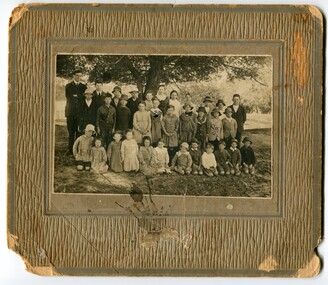
Photograph - Jarrahmond School & pupils c.1914
The Jarrahmond State School No. 2745 near Orbost was one of the earliest in this district. It opened in 1886 at the same time as Orbost and shared a teacher (Campbell McKay who was shortly afterwards replaced by John Rowe who stayed in this position until 1908). The building was financed and built by local farmers on the Stapley property. After a large and damaging flood in the nearby Snowy River in 1893 , the building was shifted to a new location. In 1926, a new building was constructed by the Vic Ed Dept. where it remained until the school was closed in 1948 and children from the Jarrahmond area were then bused to Orbost. Historical significance as one of the earliest photos of Jarrahmond School students.A b/w photo of a group of children and one adult in front of a tree. Children in the front are sitting on the ground, others are standing behind. Photo is mounted onto brown cardboard. On back of photo: Jarrahmond School c.1914. Sally Cole, Angus Cole.education, jarrahmond school, orbost -
 Orbost & District Historical Society
pamphlets, Princes Freeway - Orbost Section, 1976
Opened by the Hon. J A Rafferty, Minister for Transport, 25 November 1976, the bridge was the first of four bridges to be built as part of the freeway bypass of Orbost. Construction cost $2.4 million. This construction was an important development along the Princes Highway corridor through East Gippsland. The original highway approached the Snowy River at a very poor alignment, and several serious accidents had occurred at the Orbost end. In times of heavy flood, the highway on both sides of the river had been cut by floodwaters and during the 1971 floods, the highest ever recorded, the river was a mile wide at the crossing. Construction of the bridges commenced in January 1975, with an expectation to open the bridge across the Snowy River as soon as possible. Less than two years later, on 25 November 1976, the bridge across the Snowy River was opened to traffic, allowing the old bridge to be demolished. The remainder of the Orbost Bypass, both the floodplain crossings and the eastern section around the township itself, was declared ‘Princes Freeway’ and opened to traffic in December 1977. (ref http://mrv.ozroads.com.au) The Country Roads Board was the government authority for the construction and maintenance of main roads in Victoria between 1913 and 1983. It was succeeded by the Road Construction authority on 1 July 1983 and later merged with the Road Traffic Authority on July 1 1989 to form the Roads Corporation. James Cameron, an Orbost farming pioneer and Member of the Legislative Assembly, fathered the Country Roads Board. The opening of this Snowy River Bridge was an important development in the accessibility to the township of Orbost.Three coloured Country Roads pamphlets for the 'Princes Freeway - Orbost Section". On the front is a coloured photograph of the new construction over the Snowy River at Orbost. Inside is a program for a ceremony for the opening of the new Snowy River Bridge. There is also a black print map of the project. -
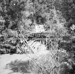
 Eltham District Historical Society Inc
Film - Video (Digital), Geoff Paine, Skipper Cottage: Stories of the Nillumbik Shire with Geoff Paine, June 2020
One of a series of videos "Stories from the Nillumbik Shire with Geoff Paine" A brief overview of the Skipper Cottage or Whitecloud and the Bootmakers cottage (mid 1850s) with Sue Thomas, partner of Adam Skipper who have lived there for about 40 years. Includes a view inside the Bootmaker's cottage. Discusses the flood plain and how the house was moved to its present site on high ground due to flooding. The high ground came about due to dumping of rubble from the quarry where the school car park is which was used to source stone to build the schoolhouse across the road. It was moved on horse and wagon approximately 200 metres. The cottage was previously a Cobb and Co stopping station for mail. When Montsalvat was being built in the 1940s, Lena Skipper who was originally from Sydney invested her money into buying Whitecloud rather than putting money into Montsalvat like many others. Upon her death, Matcham Skipper inherited the house. Seaweed was used as insulation in the ceiling and after Matcham owned it a spark from the fireplace set the seaweed on fire and gutted the front of the house which is now all one big room. Also illustrates some of the changes to the house over the years and its construction. The Elm forest has grown naturally from suckers spread from one tree.MP4 Digital file 00:05:50; 674MBvideo recording, bootmakers cottage, lena skipper, lena thomas, matcham skipper, school residence, skipper house, whitecloud cottage -
 Orbost & District Historical Society
black and white photograph, Howard D. Bulmer, first half 20th century
A new bridge over the Snowy River at Orbost was opened for traffic on June 20th 1922. It was intended as a road and rail bridge, and was again partly washed away by flood waters in 1934. After the end of the first World War the Victorian Railways considered an extension of the railhead across the river at Orbost, and in 1922 a new timber and steel girder structure, a joint Country Roads Board — Victorian Railways venture, was built and completed at a cost of £41,000 (the steel girders came from the Flinders Street viaduct reconstruction). Subsequently it was decided decided not to take the railway across the river, and the bridge was only used by road traffic. This is a pictorial record of an early bridge over the Snowy River at Orbost.A black / white postcard photograph of a bridge across a shallow river with men on horseback underneath.snowy-river-bridge -
 Greensborough Historical Society
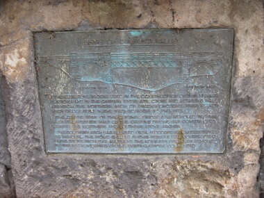
Photograph - Digital image, Dennis Ward, Bridge Plaque - Pioneer Park Greensborough, 27/03/2010
Plaque at Pioneer Reserve Greensborough: "Shire of Diamond Valley. The bluestones used in the construction of this viewing platform and in the carpark entry structure and retaining wall are from the northern arch of Greensborough's first Plenty River Bridge built in the 1860s adjacent to this site. The centre span of the original bridge was removed in 1865 when the western half of the existing bridge was constructed leaving the northern and southern stone arches. The southern arch was retained until floods in 1874 necessitated its removal. The picnic shelter in this reserve was constructed using stone from this abutment. The northern arch was removed in 1983 when widening of the existing bridge commenced."Digital copy of colour photograph.plenty river, pioneer reserve greensborough -
 Eltham District Historical Society Inc
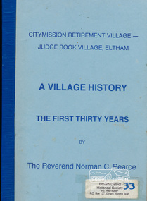
Book, Citymission Retirement Village - Judge Book Village, Eltham: A Village History; the first thirty years / The Reverend Norman C. Pearce, 1986
CityMission Retirement Village, also known as Eltham Retirement Centre, also formerly known as Judge Book Memorial Village, was officially opened on Sunday 28 October 1956. This history documents the first thirty years through to 1986. Founded by the Melbourne City Mission, the significant early history of the "village for the aged" is documented including the various challenges faced including ongoing expansions and building develoment needs and impacts of flooding from the nearby Diamond Creek. It mentions some people associated with the organisation with reference to the Eltham Auxillary which was a group of Eltham residents formed to support the organisation and its residents through activity and fundraising efforts.Softcover; 60p.judge book village, retirement village, melbourne citymission, eltham, aged care, seniors, social service, older people, housing -
 Orbost & District Historical Society
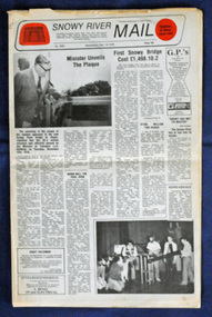
newspaper, Snowy River Mail, 1.12.1976
In early 1974, as an Engineer with the Country Roads Board, David came to Orbost as the Supervising Engineer for the construction of the new bridges which were part of an 8.4km Orbost bypass road design. This was a major project involving not only a new bridge over the Snowy River (including Lochiel Lagoon), but other bridges over Ashby’s Gulch and Watt’s Gulch. These new bridges were opened in November 1976 with the unveiling of a plaque on the eastern end of the $2.4M Snowy River Bridge. The new bridge, built by the CRB at a cost of $2.4 million, is 1.6 metres above the record flood levels of 1971. (ref. May Leatch) This newspaper contains contemporary reports of a significant event in Orbost.A Snowy River Mail newspaper, dated 1.12.1976. It contains news articles, photographs and advertisements. The main article relates to the official opening of the Snowy River Bridge and the unveiling of a plaque on the eastern approach. It also contains a history of the first Snowy River Bridge.snowy-river-bridge orbost-bridges snowy-river-mail -
 Federation University Historical Collection
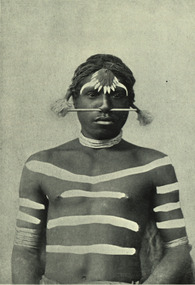
Image - black and white, Barwon River Man (New South Wales)
Digitised directly from 'The Native Races of the British Empire: Victoria' The Barwon River in New South Wales is formed through the confluence of the Macintyre River and Weir River (part of the Border Rivers system), north of Mungindi, in the Southern Downs region of Queensland. The Barwon River generally flows south and west, joined by 36 tributaries, including major inflows from the Boomi, Moonie, Gwydir, Mehi, Namoi, Macquarie, Bokhara and Bogan rivers. During major flooding, overflow from the Narran Lakes and the Narran River also flows into the Barwon. The confluence of the Barwon and Culgoa rivers, between Brewarrina and Bourke, marks the start of the Darling River.Black and white Image of an Aboriginal man from Barwon River, New South Wales. Aboriginal people from six language groups originally occupied the area of the Barwon River wetlands. These were the Ngemba, the Baranbinja, the Murrawari, the Ualayai, the Weilwan, and the Kamilaroi peoples. The Aboriginal people generally used the wetlands for hunting, fishing, and gathering uses, and for cultural association.(Wikipedia) The name "barwon" is derived from the Australian Aboriginal words of barwum or bawon, meaning great, wide, awful river of muddy water; and also baawan, a Ngiyambaa name for both the Barwon and Darling rivers. The history, culture and livelihoods of the local Aboriginal people are closely intertwined with the Barwon River and its associated tributaries and downstream flows. (Wikipedia)aborigine, aboriginal, barwon river -
 Kew Historical Society Inc
Photograph - Willsmere [Kew] Billabong, 1993
Willsmere Park is bounded by the the Yarra River, Green Acres Golf Club, Willow Grove and the Eastern Freeway. The land on which the park is now situated was bought by Thomas Wills at the Crown Land Sales of 1846 (Section 56). From the 1840s to the 1940s it was intensively farmed. The park is dominated by very large playing fields, while planting to the southern boundary was undertaken when the Eastern Freeway was built. It is only along the banks of the Yarra that there is any remnant native vegetation. Willsmere Park is of significance as an area of open land that remains from the flood plain that once dominated northern Kew. (Source: Kew Conservation Study, 1988)Original colour small format polaroid photograph of the 'Kew Billabong' in the Willsmere Park, taken on 16 September 1993."Willsmere Billabong 16.9.93"kew billabong, willsmere park, yarra river -- billabongs -
 Kew Historical Society Inc
Photograph - Willsmere [Kew] Billabong, 1993
Willsmere Park is bounded by the the Yarra River, Green Acres Golf Club, Willow Grove and the Eastern Freeway. The land on which the park is now situated was bought by Thomas Wills at the Crown Land Sales of 1846 (Section 56). From the 1840s to the 1940s it was intensively farmed. The park is dominated by very large playing fields, while planting to the southern boundary was undertaken when the Eastern Freeway was built. It is only along the banks of the Yarra that there is any remnant native vegetation. Willsmere Park is of significance as an area of open land that remains from the flood plain that once dominated northern Kew. (Source: Kew Conservation Study, 1988)Original colour small format polaroid photograph of Willsmere [Kew] Billabong on September 1993."Willsmere Billabong 16.9.93"yarra river -- floods -- kew (vic.), willsmere park -
 City of Greater Bendigo - Civic Collection
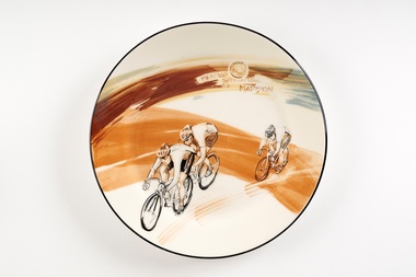
Souvenir - Ceramic platter, Bendigo Pottery, Bendigo International Madison, 2009
First held in 1972 the Bendigo International Madison is an athletics and cycling carvial which takes place in Bendigo ove the March Labour Day long weekend. Events include 400m footraces and the largest outdoor Madison event in the world. The madison is a track cycling race in which 17 pairs of riders race over a hectic 200 laps of the Tom Flood Sports Centre in Bendigo. Riders firstly try to gain a lap advantage over other teams or score sprint points during the 34 sprints dotted throughout the race. At any one time, there are riders sprinting, changing or attacking in this frantic event.Large ceramic plate with hand painted design in underglaze depicting three men bicycle racing.Front; 2009 / Bendigo International Madison Reverse; Signed Faye Brady / 09. Stamped; Bendigo Pottery / 1858 / Australiabendigo pottery, city of greater bendigo sport, city of greater bendigo tourism -
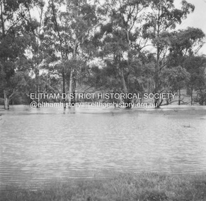
 Eltham District Historical Society Inc
Album - Photograph, J.A. McDonald, Eltham-Diamond Creek Road, 21 Oct. 1953
... floods ...18 October 1956 Proposed upstream line over Diamond Creek from Diamond Creek sideRecord of various Shire of Eltham infrastructure works undertaken during the period of 1952-1962 involving bridge and road reconstruction projects, sometimes with Eltham Shire Council Project Reference numbers quoted. It was during this period that a number of significant improvements were made to roads and new bridges constructed within the shire that remain in place as of present day (2022). In many situations, the photos provide a tangible visible record of infrastructure that existed throughout the early days of the Shire. The album was put together by or under the direction of the Shire Engineer, J.A. McDonald.infrastructure, road construction, shire of eltham, bridge construction, eltham north, floods, floodwater, glen park bridge, 1956-10-18, diamond creek (creek), eltham, railway parade, wattletree road, wattletree road bridge -
 Eltham District Historical Society Inc
Album - Photograph, J.A. McDonald, Eltham-Diamond Creek Road, 21 Oct. 1953
... floods ...18 October 1956 New downstream alignment from Eltham sideRecord of various Shire of Eltham infrastructure works undertaken during the period of 1952-1962 involving bridge and road reconstruction projects, sometimes with Eltham Shire Council Project Reference numbers quoted. It was during this period that a number of significant improvements were made to roads and new bridges constructed within the shire that remain in place as of present day (2022). In many situations, the photos provide a tangible visible record of infrastructure that existed throughout the early days of the Shire. The album was put together by or under the direction of the Shire Engineer, J.A. McDonald.infrastructure, road construction, shire of eltham, bridge construction, eltham north, floods, floodwater, glen park bridge, 1956-10-18, diamond creek (creek), eltham, railway parade, wattletree road, wattletree road bridge -
 Eltham District Historical Society Inc
Album - Photograph, J.A. McDonald, Eltham-Diamond Creek Road, 21 Oct. 1953
... floods ...18 October 1956 Proposed upstream line from Eltham sideRecord of various Shire of Eltham infrastructure works undertaken during the period of 1952-1962 involving bridge and road reconstruction projects, sometimes with Eltham Shire Council Project Reference numbers quoted. It was during this period that a number of significant improvements were made to roads and new bridges constructed within the shire that remain in place as of present day (2022). In many situations, the photos provide a tangible visible record of infrastructure that existed throughout the early days of the Shire. The album was put together by or under the direction of the Shire Engineer, J.A. McDonald.infrastructure, road construction, shire of eltham, bridge construction, eltham north, floods, floodwater, glen park bridge, 1956-10-18, diamond creek (creek), eltham, railway parade, wattletree road, wattletree road bridge -
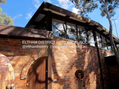 Eltham District Historical Society Inc
Photograph - Digital Photograph, Jim Connor, 21 Brougham Street, Eltham, 18 March 2012
This building at 21 Brougham Street, Eltham, known previously as The Light Factory, now Second Home restaurant, was designed by Alistair Knox and is one of the few commercial buildings he designed. It was a combined residential (rear) and factory (front) development. The Light Factory Gallery; OnlyMelbourne "The Light Factory Gallery was built in 1973 and is a classic example of his design. Exposed soaring six metre Oregon beams, handmade bricks, clerestory windows flood the building with natural daylight giving treetop views of the eucalypts that he designed the building around." The Light Factory Gallery. (2024, March 31). Retrieved from https://www.onlymelbourne.com.au/the-light-factory-galleryjim connor collection, brougham steet, eltham, alistair knox design, industries, restaurants, second home, the light factory gallery -
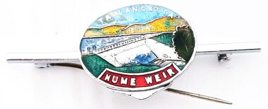 Wodonga & District Historical Society Inc
Souvenir - Tallangatta - Hume Weir Tiepin, 1980s
A wide range of items have been created as souvenirs to represent the Hume Weir on the Murray River. Work on Hume Dam started in 1919 and took 17 years to complete. Souvenir items have included chinaware, ashtrays, placemats and small jewellery items such as this tie pin. This tie pin was created as a souvenir for the town of Tallangatta. In the 1950s, the height of the Hume Weir wall was increased, resulting in a nine metre rise in the level of the water in Lake Hume. This necessitated the moving of most of the town of Old Tallangatta due to flooding. The transfer of the township by the State Rivers and Waters Supply Commission to a new site approximately 8 kilometres to the west was completed on 29 June 1956.This item is representative of many items commemorating the Hume Weir and the township of Tallangatta.A small metal and enamelled oval tie pin. It features and image of the Hume Weir.Around top edge in white: TALLANGATTA Around bottom edge" HUME WEIR"hume weir australia, tallangatta, tallangatta - the town that moved -
 Bendigo Historical Society Inc.
Document - EXTRACT FROM'' WEEKLY TIMES'' RE BOORT AND COPY OF NOTES RE DURHAM OX, 19/04/1941
Handwritten 3-page extract from'' Weekly Times'' (19/4/1941) re early days of Boort - ''Things were tough in Fifty -one (1851) - drought, fire and flood offset Gold''. By E M Webb. On third page is 1/2 page is description of an incident of early days of Gladfield told by Mrs Clarricoates Snr in 1946 - re bogging of beer cargo in creek;. B. copy of notes re early days of Durham Ox, originally written by Charlotte A Ault, Durham Ox and extract from a letter published in the Australian (sic) Post, written by Mr Wm F Sheridan. Reference to the decay of the town due to the railway line going through Pyramid Hill instead of Durham Ox (due to ''private pressure').document, newspaper, weekly times, broot. mrs clarricoates. charlotte a ault. -
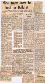 Ballarat Tramway Museum
Newspaper, The Courier Ballarat, "Nine trams may be kept in Ballarat", Aug. 1971
Yields information about the closure of the SEC operated Ballarat system - presented in an unorganised manner and without newspaper dates.Set of about 5 newspaper clippings glued to a sheet of lined paper. Main cutting titled "Nine trams may be kept in Ballarat", from The Courier Ballarat, 18/8/1971 (can read date through the back paper), about the number of trams to be kept in Ballarat, the BTPS, removal of the overhead. Other cuttings note the provision of bus stops in Ballarat, a hail storm the previous day (Friday 17/8/2005), floods, the derailment of a tram while on a tour for the Ballarat North Technical School, employment of those employees who had been retrenched and two letters re the replacement of the trams, including the aims of the BTPS to operate in Wendouree Parade. Letter re the BTPS signed by John Anderson. See also Reg item 3165 and 6665 for similar presentations of cuttings.secv, closure, employment, btps, disposal, storms -
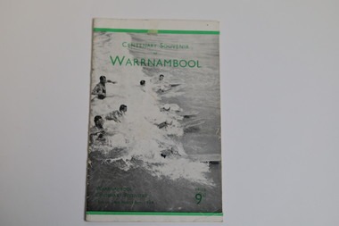 Warrnambool and District Historical Society Inc.
Booklet - Centenary Souvenir of Warrnambool, H. J. Paynter, 1934
In 1934, Victoria and Melbourne celebrated their centenaries. Realising how impossible it would be for the majority of Warrnambool residents to participate in the Victorian celebrations, the organising committee of the Warrnambool Centenary celebrations devised a week long comprehensive programme of activities including exhibitions, a pageant re-enactment at the breakwater and a mass children's display at the showgrounds. Sir Harold Gengoult Smith officially opened the Warrnambool Centenary Exhibition of Arts, Crafts, Antiques and Historical Relics. This booklet was designed and written in 1934 for the Warrnambool Centenary festivities by Frank H. Ford, Lava Street, Warrnambool. The souvenir booklet contains a brief history of Warrnambool, a map and description of Warrnambool and its facilities in 1934.The last three pages include a business directory which would be useful for research.A twenty page booklet printed on shiny paper. The front cover has a black and white photo of nine swimmers in the water (five male & four female) some with surfboards. There is a 4mm green line printed 12mm from the upper edge and a 3mm green line printed 6mm from the lower edge of the cover. There is green printing over the photograph on the front cover. On the rear cover there are two small black and white photographs of an aerial view of the city of Warrnambool and the Hopkins Falls in flood. The green line extend across the rear cover and are intersected by a perpendicular 4mm green line running from the upper to the lower edge 18mm to the left of the spine. Words are printed in black on the rear cover and the printer details are printed in green at the bottom edge.Front cover: Centenary Souvenir of Warrnambool Warrnambool Centenary Festivities 13th to 24th November 1934 Price 9d Rear Cover: Beautiful Warrnambool "City of the West" Victoria Australiawarrnambool, frank h. ford, foyle photos, a. wilkins photos, warrnambool centenary festivities 1934, warrnambool souvenir, warrnambool business directory -
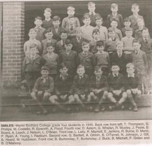 Bendigo Historical Society Inc.
Newspaper - JENNY FOLEY COLLECTION: SMILES
The Marist Brothers arrived in Bendigo in 1893 and began classes for boys in makeshift classrooms at St Killians. By the next year they had moved to a permanent school in McCrae Street. In 1983 Marist amalgamated with St Mary's to form a co-educational school, "Catholic College.Bendigo Advertiser ''The way we were'' from 2003. Smiles: Marist Brothers College grade four students in 1946. Back row from left: T. Thompson, G. Phillips, M. Costello, R. Epworth, A. Flood. Fourth row: D. Astern, G. Whelan, R. Mustey, J. Peate, B. Board, A. Leach, J. Nelson, L. O'Brien. Third row: L. Laity, R. Marriott, E. Jenkins, R. Burns, D. Mann, P. Ryan, A. Young, I. Raeburn. Second row: G. Bartlett, A. Gibbin, B. O'Farrell, N. Johnson, J. Gill, B. Heard, M. Hutchinson. Front row: B. Burtonclay, F Burtonclay, J. Buck, B. Mitchell, F. Green and B. O'Mahony. The clip is in a folder.newspaper, bendigo advertiser, the way we were -
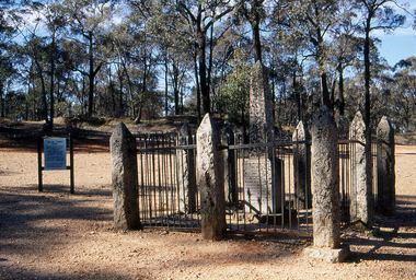 Federation University Historical Collection
Slide, Welcome Stranger Monument, c1970
The first recorded discovery of gold in Moliagul was in September 1852 and, before long, the area was flooded with over 4,000 miners. Two of those miners, John Deason and Richard Oates, had arrived in Bendigo in 1954 seeking their fortune. After eight years of little success, the friends moved to Moliagul and pegged a puddling claim. On 05 February 1869, Deason discovered a nugget near the roots of a tree, just 3cm beneath the soil. With the help of Oates, he uncovered the largest recorded alluvial gold nugget – known as the Welcome Stranger. The 61cm x 31cm nugget was taken to Dunolly to be measured on the bank’s scales, however at 69kg the gold needed to be broken on an anvil to actually fit on the scales.Photograph of the monument for the Welcome Nugget, a large gold nugget found by John Deason and Richard Oates at Moliagul.Obelisk inscription Welcome Stranger Nugget On this spot the largest nugget of gold in the world was discovered on the 5th February 1869 by John Deason and Richard Oates. Weight 2316 oz, Value £9553 Erected by the Mines Department 1897 Henry Foster Minister of Mines, D. J. Duggan M.L.A. Member for Dunollywelcome nugget, welcome nugget monument, john deason, richard oates -
 Kiewa Valley Historical Society
Book - Reference S.E.C. History x4, Brown Power A Jubilee History of the State Electricity Commission of Victoria, first published 1969
Although this book revolves around the supply of power(Electricity) from brown coal it does cover the period 1937 onwards when the Kiewa Hydro Electricity Scheme was first mooted. This area was believed to be far away from aerial bombardment should the coastal power stations be attacked by air in World War II(1939 -1945). After the war, post 1945, the demand for a continual power supply, not affected by seasonal coastal flooding was together with a lower cost of hydro electricity power the major incentive for the Victoria Government of the day to proceed (in the 1940s) with The Kiewa Hydro Electricity Scheme. In 1946 Victorian government sought greater independence from the New South Wales black coal supplies.The significance of this book to the Kiewa Valley and its outlying regions is that it details why the development of an Alpine region was and now still is pocketed with a European flavour both in buildings and in town vegetation(trees and flowers). European (post World War II refugees) where attracted to these alpine areas not only for hard labouring positions but also for their technical skills and some street names offer a distinct European lineage rather than convict or of earlier English settler. The construction phase accommodation continued after completion of the Kiewa Hydro Electricity Scheme to become popular venues for an increasing winter tourism industry. This book has a brown hard cover encapsulated by a cream sleeve with brown and black print. On the front of the sleeve is an embossed circular motif with centre piece S.E.C. emblem and around this the words "50 YEARS OF SERVICE" and below this" STATE ELECTRICITY COMMISSION OF VICTORIA". The book contains 313 double sided pages of black print and black and white photographs.On front of paper sleeve "Brown Power A Jubilee History of the State Electricity Commission of Victoria Cecil Edwards". On the second page, below the Title "Brown Power" there is a pasted, printed presentation certificate, with the S.E.C. emblem and these printed words " Presented by the Chairman and Commissioners to A.G. MILLIST, ESQ. in recognition of long and valued service with the Commission"electricity, victorian power supplies, hydro electricity, brown coal, cecil edwards -
 Tatura Irrigation & Wartime Camps Museum
Video Tapes, Channels
Nine 20 minute video tapes "Channels" prepared by the Rural Water Commission from December 1992 to the end of the Rural Water Commission in June 1994.|Tape 1. Goulburn Murray Region.| Tape 2. New Tatura Office.| Tape 5. Yarrawonga Hydro project, Lake Makoan; Torrumbary Weir.|Tape 6. Ardmona Drain 11; Floods; Torrumbary Weir; Tatura Offices; Big Eildon Project.|Tape 7. Farm Dams.|Tape 8. Water Auction; Channel Ditching; Irrigation Ordering; Tatura Offices; Torrumbarry Weir; Sir Ronald East.|Tape 9. Torrumbary Weir; Mosquito Depression Drain; Eildon Tower Outlet; Farewell Message.9 video tapes prepared by the Rural Water Commission. -
 Eltham District Historical Society Inc
Negative - Photograph, J.A. McDonald, Eltham-Diamond Creek Road, 21 Sep 1959
Bridge construction Eltham-Diamond Creek road over the Diamond Creek (Wattletree Road), Eltham, September 1959 After some delay in receiving funds, work started on the bridge approaches in early September 1959. Traffic was still using the old bridge upstream. On Sunday, 20 September 1959, heavy flooding occurred in the stream and at 3:53 pm the old bridge was washed out. This photo was taken the day after. The bridge was originally built as a replacement for an older private bridge built by a man named Foley around 1880. In 1911 Heidelberg and Eltham agreed to share the costs to build a new bridge. Construction began in June 1915 and it was officially opened by Cr. Taylor on Cup Day, November 1915.Record of various Shire of Eltham infrastructure works undertaken during the period of 1952-1962 involving bridge and road reconstruction projects, sometimes with Eltham Shire Council Project Reference numbers quoted. It was during this period that a number of significant improvements were made to roads and new bridges constructed within the shire that remain in place as of present day (2022). In many situations, the photos provide a tangible visible record of infrastructure that existed throughout the early days of the Shire. The album was put together by or under the direction of the Shire Engineer, J.A. McDonald.infrastructure, shire of eltham, bridge construction, bridge, diamond creek (creek), eltham, eltham north, glen park bridge, 1959-09-21, flood damage, wattletree road bridge -
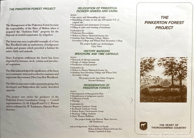 Melton City Libraries
Pamphlet, The Pinkerton Forest Project, 1992
"The Pinkerton family is remembered in Melton in part due to the historic graves of the original settler, Margaret Pinkerton, and four of her grandchildren, which were marked by a memorial cairn in 1931. Changes to sewage flood zoning in the area in the 1990s necessitated that these burials be relocated. Members of the Melton & District Historical Society oversaw a project to relocate the Pinkerton graves and cairn 200 metres from their original site to their current resting place at Mount Cottrell. This relocation ceremony took place on 8 November 1992, with the participation of local school students and with Pinkerton descendants playing a central role. This occasion also marked the opening of the Pinkerton Forest Project, which saw 50 hectares of degraded woodland in Surbiton Park protected for regeneration". Pamphlet about the relocation of the Pinkerton graveslandscapes of significance, local identies, local special interest groups, pioneer families -
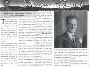 Bendigo Historical Society Inc.
Newspaper - LONG GULLY HISTORY GROUP COLLECTION: THE MINE FLOODING CRISIS - FINALE OF THE VICTORIA QUARTZ
Copy of an article from the Bendigo Weekly titled Discover Bendigo The Mine Flooding Crisis - Finale of the Victoria Quartz by James Lerk. The lack of suitable machinery, insufficient knowledge of where the water was coming from, need for Government support, and the pegged price of gold, all contributed to the cessation of deep mining. The Victoria Quartz decided to allow tributers for work the upper levels. By 1913, the Company found it uneconomic to allow the tributers to continue working the upper levels and the poppet head and machinery were sold. During the Great Depression Ernest Smith, Davic Holden, Jack Harrison and David Patullo worked above the water line and did well enough to help their families from the worst effects of the Great Depression. Later Dave Patullo continued to work at the Victoria Quartz while the other three obtained employment in other mines. The article has a photo of David Patullo.bendigo, history, long gully history group, the long gully history group - the mine flooding crisis - finale of the victoria quartz, bendigo weekly, james lerk, victoria quartz mine, brough smyth, bendigo advertiser, victoria quartz company, great depression, ernest smith, david holden, jack harrison, david patullo, government battery eaglehawk -
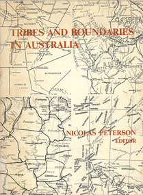 Victorian Aboriginal Corporation for Languages
Book, Nicolas Peterson, Tribes and boundaries in Australia, 1976
Some ecological bases for Australian tribal boundaries /? Norman B. Tindale Man and ecology in the highlands of southeastern Australia : a case study /? Josephine Flood The natural and cultural areas of Aboriginal Australia : a preliminary analysis of population groupings with adaptive significance /? Nicolas Peterson 'The chain of connection' : the material evidence /? D.J. Mulvaney Realities and transformations : the tribes of the Western Desert of Australia /? Joseph B. Birdsell Structure, event and ecology in Aboriginal Australia : a comparative viewpoint /? Aram A. Yengoyan Territoriality and the problem of demarcating sociocultural space /? Ronald M. Berndt Communication and change in mythology /? Kenneth Maddock Levels of organisation and communication in Aboriginal Australia /? D.H. Turner Boundaries and kinship systems in Aboriginal Australia /? F.G.G. Rose Tribes, languages and other boundaries in northeast Queensland /? R.M.W. Dixon Aboriginal language distribution in the Northern Territory /? E.P. Milliken.maps, b&w photographs, diagramsecology, environment, sociology, kinship systems, language distribution -
 Kew Historical Society Inc
Photograph, J F C Farquhar, Dight's Falls, 1891
At the beginning of the 1890s, the Kew businessman and Town Councillor, Henry Kellett, commissioned J.F.C. Farquhar to photograph scenes of Kew. These scenes included panoramas as well as pastoral scenes. The resulting set of twelve photographs was assembled in an album, Kew Where We Live, from which customers could select images for purchase.The preamble to the album describes that the photographs used the ‘argentic bromide’ process, now more commonly known as the gelatine silver process. This form of dry plate photography allowed for the negatives to be kept for weeks before processing, hence its value in landscape photography. The resulting images were considered to be finely grained and everlasting. Evidence of the success of Henry Kellett’s venture can be seen today, in that some of the photographs are held in national collections.It is believed that the Kew Historical Society’s copy of the Kellett album is unique and that the photographs in the book were the first copies taken from the original plates. It is the first and most important series of images produced about Kew. The individual images have proved essential in identifying buildings and places of heritage value in the district.Dight’s Falls in Studley Park is an artificial weir built on a natural rock bar across the Yarra. The weir was built in the 1840s to provide water to the ‘Ceres’ flour mill, one of the earliest industrial sites in Melbourne. The falls were later to be named after the owner of this mill. In 1888, William Guilfoyle, Director of the Melbourne Botanical Gardens had called for fresh water to be piped from above the weir to the Botanical Gardens, using a pumping station on the Kew side of the Falls, a holding reservoir in Walmer Street and a series of pipes from there to the Gardens. This system was opened in May 1891. Farquhar’s photograph of the man-made weir obscures the industrial activity on both sides of the Falls and focusses solely on the river and the surrounding natural vegetation. The photograph probably predates the disastrous flooding of the Yarra River in July 1891, the greatest to have occurred in the Colony since the foundation of Melbourne.Dight's Fallskew illustrated, kew where we live, photographic books, henry kellett, yarra river -
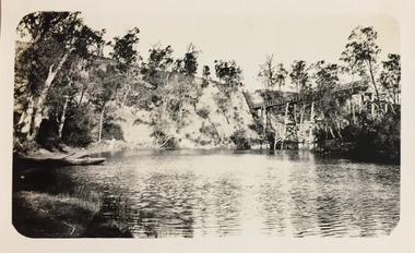 Kew Historical Society Inc
Photograph - Zig-Zag Bridge, 1924
Henry Beater Christian (1886-1962) , was a descendant of one of the earliest settler families in Kew. Employed at the Kew Asylum as a 'public servant', he was a skilled amateur photographer, photographing numerous scenes in Kew and on his travels around Victoria. The majority of his photographs date from 1916 to 1929. His finest photographs are housed in two photograph albums. Digital copy of a photograph from page 8 of the 47-page photograph album containing 261 gelatinous silver images, loaned by Diane Washfold with permission given to digitise and hold a copy in our collection. This photograph reveals how the photographer, Henry Christian, positioned himself to take the photograph from the angle in which he was interested. A skilled canoeist, an empty canoe is on the left of the photo that he apparently he used to access his vantage point. His subject, the Zig-Zag Bridge linked the grounds of the Yarra Bend and Kew Asylums. The wooden bridge was constructed in the 1870s and lasted through numerous floods until its destruction in 1929. A horizontal structure, one climbed steps to reach the higher Yarra Bend bank. At the Studley Park end, the bridge descended via a staircase to reach the much lower bank. "Zig-Zag Bridge"henry beater christian (1886-1962), landscape photography, kew (vic.) — yarra river, christian-washfold collection, photograph albums, zig-zag bridge -
 Kew Historical Society Inc
Photograph - Zig-Zag Bridge, 1924
Henry Beater Christian (1886-1962) , was a descendant of one of the earliest settler families in Kew. Employed at the Kew Asylum as a 'public servant', he was a skilled amateur photographer, photographing numerous scenes in Kew and on his travels around Victoria. The majority of his photographs date from 1916 to 1929. His finest photographs are housed in two photograph albums. Digital copy of a photograph from page 8 of the 47-page photograph album containing 261 gelatinous silver images, loaned by Diane Washfold with permission given to digitise and hold a copy in our collection. This photograph reveals how the photographer, Henry Christian, positioned himself to take the photograph from the angle in which he was interested. A skilled canoeist, an empty canoe is on the left bank that he apparently he used to access his vantage point. His subject, the Zig-Zag Bridge linked the grounds of the Yarra Bend and Kew Asylums. The wooden bridge was constructed in the 1870s and lasted through numerous floods until its destruction in 1929. A horizontal structure, the walkway was reached via a wooden staircase on the Studley Park end. The steps were requires due to the different levels of the banks on this stretch of the river. "Zig-Zag Bridge"henry beater christian (1886-1962), landscape photography, kew (vic.) — yarra river, christian-washfold collection, photograph albums, zig-zag bridge