Showing 110511 items matching " roads"
-
 Camberwell Historical Society
Postcard - Photo postcard, 1989
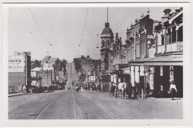
Glossy black and white photograph with white border on a postcard, depicting Burke Road dating around 1923. Photograph shows people crossing tram line surrounded by buildings, with horse and cart in the foreground.Back of postcard: Burke Road, Camberwell, c. 1923. La Trobe Collection, State Library of Victoria. -
![Map, [Plan for road to give J. Allan access to permanent water at Coimadai] circa 1870s](/media/collectors/5e461d8021ea67224c82f2a1/items/67735190d671e67dd573a84c/item-media/6773533dd671e67dd573cd90/item-fit-380x285.jpg) Bacchus Marsh & District Historical Society
Bacchus Marsh & District Historical SocietyMap, [Plan for road to give J. Allan access to permanent water at Coimadai] circa 1870s
The date of this map or plan is uncertain but it appears to be from the early to mid 1870s. One of the landholders identified on the plan, James Allan of Coimadai died suddenly on the 9th July, 1874 (see Bacchus Marsh Express, 11 July, 1874, page. 3). There are mentions of an Allans Road at Coimadai in the Bacchus Marsh Express between 1887 and 1942.Single page map showing an excision of land belonging to Charles Ross which was selected to construct a road to give another landholder, J. Allan access to permanent water. Scale 1 chain to 1 inch. Part of a set of maps which are pasted into a bound volume containing 76 maps or plans in total. High resolution digital image stored on BMDHS computer network. Plan showing Excisions from Ross's selection and 1 chain road thro' the said selection in Coimadai to give J. Allan access to permanent water. Alistair ?? Shire Eng? 6?/5/7?coimadai victoria maps, coimadai roads and streets -
 Marysville & District Historical Society
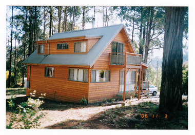
Photograph (Item) - Colour photograph, 11-03-2006
A colour photograph of a house taken in Kings Road in Marysville in Victoria.A colour photograph of a house taken in Kings Road in Marysville in Victoria. This house, along with most of Marysville's buildings, was destroyed in the 2009 Black Saturday bushfires.kings road, marysville, victoria, photograph, 2009 black saturday bushfires -
 Whitehorse Historical Society Inc.
Article, Livingstone School Has Schedule, 21/10/1976 12:00:00 AM
Plans for the new Primary SchoolPlans for the new Primary School in Livingstone Road, Vermont South, due to open in 1978, on display.Plans for the new Primary Schoolprimary schools, walton, trevor, vermont south primary school -
Whitehorse Historical Society Inc.
Map, Map of Mitcham, 1916?
Copy of early map of Mitcham.Copy of early map of Mitcham showing main roads and large blocks of land with owners' namesCopy of early map of Mitcham. mitcham road mitcham, heatherdale road mitcham, whitehorse road mitcham, morton, william, ainger, f, morgan, r. r., harding, w, sergeant, r, mcclelland, john, wilson, w, cook, j -
 Whitehorse Historical Society Inc.
Photograph - Black and white photograph, Williams Road Blackburn circa 1924. Electricity poles showing and unmade road
Williams Road Blackburn. Two early photos in black and white.Two early black and white photographs of Williams Road Blackburn prior to lots being sold.blackburn, williams road, 1924 -
Whitehorse Historical Society Inc.
Article, Traders Trapped, 1985
Eight Businesses at Houston Shopping Centre, Middleborough Road, Box Hill.Eight Businesses at Houston Shopping Centre, Middleborough Road, Box Hill, facing rezoning of land reserved for the Healesville Freeway. Traders say they are being treated unfairly by the Road Construction Authority, owner of the land.Eight Businesses at Houston Shopping Centre, Middleborough Road, Box Hill. land use, anderson camp -
 Whitehorse Historical Society Inc.
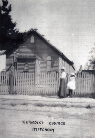
Photograph, Methodist Church - Mitcham
In 1887, land on the south east corner of Whitehorse Road and Richards Street, Mitcham was purchased and in 1888 a weatherboard church was erected. This early church was used until 1921, when the building was moved to a site in Mitcham Road, just north of Whitehorse Road. The church was enlarged and re-opened in 1921Black and white photograph of the Mitcham Methodist Church which was erected in 1888, on the corner of Whitehorse Road and Richard Street, Mitchammethodist church, mitcham -
 Ringwood and District Historical Society
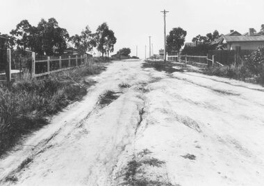
Photograph, Barkly Street, Ringwood - c1948
Black and white photograph of unmade road in poor condition. Houses in background.Typed below photograph, "Barkly St., Ringwood c.1948". Catalogue card states, "Taken about 100 yards down from Wantirna Road. Car probably going south along Wantirna Road. House far right now block of flats (Sept. 1975) but next two houses up street are there. Haig St. just behind car. Fence on house to left still there and curved front path. Shop visible corner Haig St. to left of big pole still there." -
 Phillip Island and District Historical Society Inc.
Photograph, 1978/79
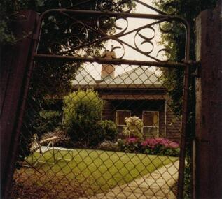
W Reid, a cousin of O Underdown and descendant of Captain David Reid, lived here in Reid Road, Rhyll.Coloured photograph of family home of late W Reid, Reid Road, Rhylllocal history, photographs, buildings - historical, coloured photograph, john cook, phillip island, w reid -
 Melbourne Tram Museum
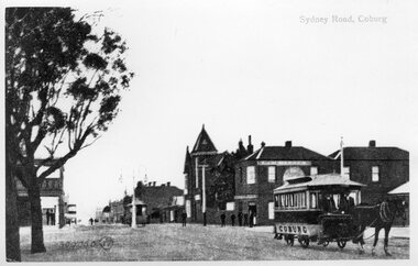
Photograph - Black and White Coburg Horse Tram - Sydney Road and Bell St
Photograph shows a north bound horse tram drawn by a single horse at the corner of Sydney Road and Bell St. This tramline was operated by the Northern Tramway Co. from 1889 to 1915 when it was closed and the line electrified by the Melbourne Brunswick and Coburg Tramways Trust to build their lines. See reference for an extensive history of this horse tram line.Yields information about the Coburg horse tram and the streetscape. Black and White photograph of a horse tram at the corner of Bell St and Sydney Road. Photo has the title of "Sydney Road Coburg"northern tramway co, horse trams, coburg, bell st, sydney road, bell street, trams, tramways -
 Royal District Nursing Service (now known as Bolton Clarke)
Photograph - Photograph, black and white, 23.05.1967
This photograph shows the typical road conditions encountered by RDNS District Sisters during their days work visiting patients to administer nursing care. From its inception in 1885 their Trained nurses (Nurses) of the then named Melbourne District Nursing Society (MDNS), later named Royal District Nursing Service (RDNS) gave high quality nursing care to patients in their own homes. They nursed patients referred by Hospitals and General Practitioners giving treatments, such as injections, wound care and doing other procedures, as well as assisting them with general care when required. District Nursing has had various modes of transport over the last 130 plus years. At first, from 1885 as MDNS, the Nurses walked the streets and lane ways amid the slums of central Melbourne. As the Society expanded public transport was used; bicycles were bought by the Society in 1903 and used in inner areas until 1945. During the Spanish flu epidemic, in 1919, MDNS appealed for assistance to procure Motor vehicles so the Nurses could visit an influx of cases. Through trusts, grants and donations four 'Ford 'T Model' cars were procured which enabled the Nurses to triple their visits. Through constant use the cars were in such a poor state they were sold in 1927. A Motor Auxiliary was formed in 1929 to take their Trained nurses (Sisters) to patients, and some Sisters used their own cars; even a motorcycle was used by one Sister in 1933. All these forms of transport were intermingled until, having received Royal patronage; the now Royal District Nursing Service (RDNS) had its own full fleet of vehicles by the mid 1960s. In many areas there were unsealed roads, in various conditions, which the Sisters negotiated to reach their patients to give care. By 2009 there were 598 cars in the fleet and the nurses travelled 9 million 200,000 kilometres – this is equivalent to 12 trips to the moon and back. In the centre of this black and white photograph is a Royal District Nursing Service, (RDNS) Sister in her RDNS grey car driving up the lower section of a hill on a dirt road. The car's rear black Victorian number plate, with 'JPH - 516' written on it can be seen. Dust is rising on either side of the car. In the foreground the road runs downward to a dip and then up the hill; trees are along either side of the road, and dirt and stones are seen on the side of the road in the left foreground. Photographers stamp. Quote No. GE 95rdns, royal district nursing service, rdns transport -
 Whitehorse Historical Society Inc.
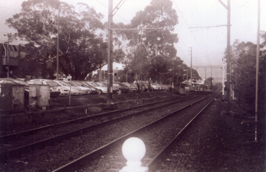
Photograph, Railway Track Looking East, 1/06/2009
One of a collection of photographs taken of the Nunawading Railway Station prior to the lowering of the railway line and building of the new railway station on the western side of Springvale Road so that the Springvale Road Rail Crossing can be eliminated.Black & white photograph of he precinct surrounding the Nunawading Station and the Springvale Road Railway crossing. This photograph is of the railway track looking east from railway crossing in Springvale road. Note the railway station in the distance. See NP 3545 to NP3567 for the complete set of photographsnunawading railway station, springvale road nunawading, redevelopment of railway line/springvale road. -
Stawell Historical Society Inc
Document - Report, Nicole Start, Conservation Status of Roadsides in the Shire of Stawell, 1991
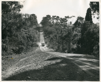
Covers: Shire, roadsides, Assessment: Species, Flora, Grazing, Cropping, Gravel, Noxious weeds, Firebreaks, Road Design. With loos maps X 2 in back. Author Nicole StartPlastic Front Cover. Yellow Paper with Photo of a country road.Nicole Start Biological and Chemical Sciences Ballarat University Collage December 1991 -
 Eltham District Historical Society Inc
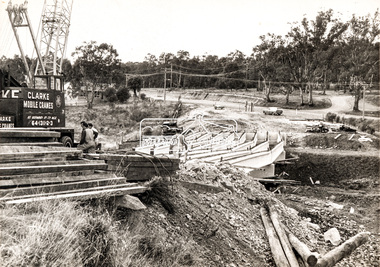
Photograph, Construction of new bridge over the Plenty River, Main Road, Lower Plenty, c.Aug. 1966
Construction of the Main Road bridge over the Plenty River. Includes structural members, construction personnel, vehicles and a Clarke mobile crane.Local significanceBlack and white printMarking on back of photograph - Plenty River Bridge Main Road 1969 (sic)lower plenty, main road, plenty river, bridge, bridge construction, civil engineering, cranes, mobile cranes -
 Eltham District Historical Society Inc
Slide, Thompson Crescent, Research, May 1983
... roads ...One of a series of images of roads and infrastructure taken by Eltham Shire Council Planning and Engineering officers, May 1983 specifically looking at road conditions and drainage in Research (Vic.) around Thompson Crescent.35 mm colour positive transparency (1 of 11) Mount - Kodak Kodachrome Cardroads, infrastructure, research (vic.), thompson crescent, howell court -
 Eltham District Historical Society Inc
Slide, Morelle Street, Research, May 1983
... roads ...One of a series of images of roads and infrastructure taken by Eltham Shire Council Planning and Engineering officers, May 1983 specifically looking at road conditions and drainage in Research (Vic.) around Thompson Crescent.35 mm colour positive transparency (1 of 11) Mount - Kodak Kodachrome Cardroads, infrastructure, research (vic.), finnigan street, morelle street -
 Eltham District Historical Society Inc
Slide, Finnigan Street, Research, May 1983
... roads ...One of a series of images of roads and infrastructure taken by Eltham Shire Council Planning and Engineering officers, May 1983 specifically looking at road conditions and drainage in Research (Vic.) around Thompson Crescent.35 mm colour positive transparency (1 of 11) Mount - Kodak Kodachrome Cardroads, infrastructure, research (vic.), finnigan street, morelle street -
 Eltham District Historical Society Inc
Slide, Brenda Street, Research, May 1983
... roads ...One of a series of images of roads and infrastructure taken by Eltham Shire Council Planning and Engineering officers, May 1983 specifically looking at road conditions and drainage in Research (Vic.) around Thompson Crescent.35 mm colour positive transparency (1 of 11) Mount - Kodak Kodachrome Cardroads, infrastructure, research (vic.), brenda street, research-warrandyte road -
 Eltham District Historical Society Inc
Slide, Thompson Crescent, Research, May 1983
... roads ...One of a series of images of roads and infrastructure taken by Eltham Shire Council Planning and Engineering officers, May 1983 specifically looking at road conditions and drainage in Research (Vic.) around Thompson Crescent.35 mm colour positive transparency (1 of 11) Mount - Kodak Kodachrome Cardroads, infrastructure, research (vic.), norman road, thompson crescent -
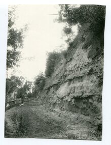 Orbost & District Historical Society
Photograph - Hofen's cutting, Bete Bolong, Orbost district, early 20th century
This photograph is of a cutting on a road at Bete Bolong known as Hofen's Cutting. This photograph was taken c. 1906 when transport was by horse, wagon and prior to cars and railways.This is a pictorial record of early Bete Bolong showing a road through a cutting which was known as Hofen's cutting. Two black / white photographs showing a dirt road heading down a cutting with a post and rail wooden fence on the left side in the background. In 958.1 there is a cut - away hillside beside the dirt road.on back - "Newmerella" (note: this location is at Bete Bolong and not on Newmerella Hill) 958.1 - on back - "Hofen's Bluff 1906"bete bolong, orbost, tracks/roads -
Phillip Island and District Historical Society Inc.
Publication, November, 1969
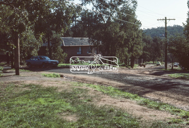
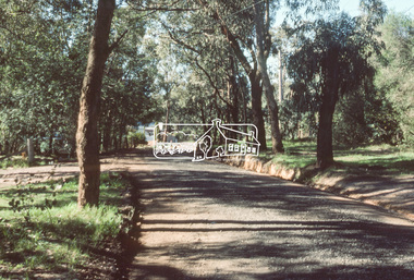
Produced and donated by Country Roads Board, 1969. Presented by Bill Papworth.Brochure produced by the Country roads Board for the Official Opening of the new bridge, November 21, 1969.local history, documents, publications, civil engineering, bridges, history of the phillip island bridge, phillip island bridges -
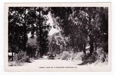 Marysville & District Historical Society
Postcard (item) - Black and white postcard, Murray Views, Murray Views No. 30. Road Scene, Marysville, Vic, Post 1929
An early black and white photograph of a road scene taken in Marysville, Victoria.An early black and white photograph of a road scene taken in Marysville, Victoria. This postcard was produced by Murray Views in Gympie, Queensland as a souvenir of Marysville."Kooringa"/ Monday Dear Mother/ Just a short note/ to say I am well & having a/ good holiday. Went on the/ Cumberland Valley trip last/ week - was very enjoyable./ To-day we are doing the Eildon/ Weir trip - all day. Have had/ fairly good weather - was able/ to go out every day. Will/ ring you later in the week/ about meeting me. If the/ strike is still on will probably/ get you to order a taxi for/ me. Lots of love/ Margaretmarysville, victoria, postcard, murray views, souvenir -
 Lakes Entrance Historical Society
Photograph - Keith Graham of Woodsedge Gallery, Lakes Post Newspaper, 1/06/1994 12:00:00 AM
Keith Graham of Woodsedge Gallery Baades Road Lakes Entrance VictoriaBlack and white photograph of Keith Graham of Woodsedge Gallery Baades Road Lakes Entrance Victoriaarts, exhibition -
 Eltham District Historical Society Inc
Slide, Belmont Crescent, Montmorency, c. Mar. 1981
... roads ...One of a series of images of road infrastructure focussed on Belmont Crescent in Montmorency taken by Eltham Shire Council Planning and Engineering officers. They provide perspective of the changes in housing styles and road development that began sweeping in from the mid 1970s with increasing urbanisation of what was once more outlying suburbs and regions. All images have been identified with GPS35 mm colour positive transparency (1 of 8) Mount - Kodak Kodachrome CardProcessed Mar 1981infrastructure, montmorency, roads, belmont crescent -
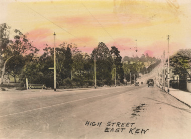 Kew Historical Society Inc
Postcard - High Street, East Kew, c.1927
High Street, Kew is the main Road in Kew. It was once also known as Bulleen Road, or Main Street. This section of the road is in Kew, although the narrow section on the right hand side of the photo is now Kew East. High Street progresses through a number of significant road junctions: beginning at Barkers Road; progressing through the intersection of Studley Park Road, Denmark Street and Princess Street at Kew Junction; branching left at the junction with Cotham Road; before reaching the junction with Valerie Street and Harp Road. It reaches its end at the junction of Burke Road, Kilby Road, Bulleen Road and High Street itself. An early photograph of this iconic Memorial that locates it in its context. Small, colorised real photo postcard of High Street, East Kew. Electric light poles line the road. Victoria Park is on the left and further on the horizon is the Boroondara General Cemetery.high street -- kew (vic.), victoria park, tram lines -- kew (vic.) -
 Clunes Museum
photograph, KODAK
VIEW OF GRAVEL ROAD FROM CLUNES TOWNSHIP TO STATION FLAT. LOWER PART OF PORT PHILLIP MINE ON LEFT OF PHOTO.VIEW OF ROAD LEADING TO STATION FLAT, CLUNES - ANGLICAN CHURCH ON HILL IN BACKGROUNDlocal history, clunes landscape.