Showing 927 items matching " write"
-
 Kew Historical Society Inc
Plan - Subdivision Plan, J R Mathers & McMillan, Glenferrie Road, Cotham Road, Belmont Avenue, Stirling Street, 1910-1930
Pru Sanderson, in her groundbreaking ‘City of Kew Urban Conservation Study : Volume 2 - Development History’ (1988), summarised the periods of urban development and subdivisions of land in Kew. The periods that she identified included 1845-1880, 1880-1893, 1893-1921, 1921-1933, 1933-1943, and Post-War Development. These periods were selected as they represented periods of rapid growth or decline in urban development. An obvious starting point for Sanderson’s groupings involved population growth and the associated economic cycles. These cycles also highlighted urban expansion onto land that was predominantly rural, although in other cases it represented the decline and breakup of large estates. A number of the plans in the Kew Historical Society’s collection can also be found in other collections, such as those of the State Library of Victoria and the Boroondara Library Service. A number are however unique to the collection.The Kew Historical Society collection includes almost 100 subdivision plans pertaining to suburbs of the City of Melbourne. Most of these are of Kew, Kew East or Studley Park, although a smaller number are plans of Camberwell, Deepdene, Balwyn and Hawthorn. It is believed that the majority of the plans were gifted to the Society by persons connected with the real estate firm - J. R. Mathers and McMillan, 136 Cotham Road, Kew. The Plans in the collection are rarely in pristine form, being working plans on which the agent would write notes and record lots sold and the prices of these. The subdivision plans are historically significant examples of the growth of urban Melbourne from the beginning of the 20th Century up until the 1980s. A number of the plans are double-sided and often include a photograph on the reverse. A number of the latter are by noted photographers such as J.E. Barnes.A ‘proposed’ subdivision of the area in the vicinity of Cotham and Glenferrie Roads and Belmont Avenue depicts an alternate vision for how the land might be divided into lots. When comparing this undated proposed subdivision with a modern map, it is possible to see why the subdivision did not eventuate. The right-of-way shown in the plan as beginning in Belmont Avenue was to be extended much further, preventing the lower lots from being created in the proposed shapes. Identifying the date of the name change may assist in the dating of the proposed subdivision. In faded writing at the top of the plan is an annotation referring to ‘Abbotsford’ and Finlayson’s Agency.subdivision plans - kew, glenferrie road, cotham road, belmont avenue, stirling street -
 Kew Historical Society Inc
Plan - Subdivision Plan, Maxwelton, Kew, 1920-1940
Pru Sanderson, in her groundbreaking ‘City of Kew Urban Conservation Study : Volume 2 - Development History’ (1988), summarised the periods of urban development and subdivisions of land in Kew. The periods that she identified included 1845-1880, 1880-1893, 1893-1921, 1921-1933, 1933-1943, and Post-War Development. These periods were selected as they represented periods of rapid growth or decline in urban development. An obvious starting point for Sanderson’s groupings involved population growth and the associated economic cycles. These cycles also highlighted urban expansion onto land that was predominantly rural, although in other cases it represented the decline and breakup of large estates. A number of the plans in the Kew Historical Society’s collection can also be found in other collections, such as those of the State Library of Victoria and the Boroondara Library Service. A number are however unique to the collection.The Kew Historical Society collection includes almost 100 subdivision plans pertaining to suburbs of the City of Melbourne. Most of these are of Kew, Kew East or Studley Park, although a smaller number are plans of Camberwell, Deepdene, Balwyn and Hawthorn. It is believed that the majority of the plans were gifted to the Society by persons connected with the real estate firm - J. R. Mathers and McMillan, 136 Cotham Road, Kew. The Plans in the collection are rarely in pristine form, being working plans on which the agent would write notes and record lots sold and the prices of these. The subdivision plans are historically significant examples of the growth of urban Melbourne from the beginning of the 20th Century up until the 1980s. A number of the plans are double-sided and often include a photograph on the reverse. A number of the latter are by noted photographers such as J.E. Barnes.The subdivision, ‘Maxwelton’, included four lots in East Kew, at the northwest corner of Burke Road and Cotham Road. Lot 3 is identified as the location of an existing house. The site of the subdivision equates to that parcel of land where a contemporary block of three storey apartments at 1245 Burke Road is now located.subdivision plans - kew, mazwelton subdivision, burke road -- kew (vic.), cotham road -- kew (vic.) -
 Kew Historical Society Inc
Plan - Subdivision Plan, Normanby Estate, East Kew, 1913
Pru Sanderson, in her groundbreaking ‘City of Kew Urban Conservation Study : Volume 2 - Development History’ (1988), summarised the periods of urban development and subdivisions of land in Kew. The periods that she identified included 1845-1880, 1880-1893, 1893-1921, 1921-1933, 1933-1943, and Post-War Development. These periods were selected as they represented periods of rapid growth or decline in urban development. An obvious starting point for Sanderson’s groupings involved population growth and the associated economic cycles. These cycles also highlighted urban expansion onto land that was predominantly rural, although in other cases it represented the decline and breakup of large estates. A number of the plans in the Kew Historical Society’s collection can also be found in other collections, such as those of the State Library of Victoria and the Boroondara Library Service. A number are however unique to the collection.The Kew Historical Society collection includes almost 100 subdivision plans pertaining to suburbs of the City of Melbourne. Most of these are of Kew, Kew East or Studley Park, although a smaller number are plans of Camberwell, Deepdene, Balwyn and Hawthorn. It is believed that the majority of the plans were gifted to the Society by persons connected with the real estate firm - J. R. Mathers and McMillan, 136 Cotham Road, Kew. The Plans in the collection are rarely in pristine form, being working plans on which the agent would write notes and record lots sold and the prices of these. The subdivision plans are historically significant examples of the growth of urban Melbourne from the beginning of the 20th Century up until the 1980s. A number of the plans are double-sided and often include a photograph on the reverse. The Normanby Estate, which was adjacent to Normanby Road, Kew East, included thirty-one lots for sale. Streets on the subdivision plan include Adeney Avenue, Park Hill Road, Normanby Road, Weir Street and Wharton Street. Cotham Road and its tramway are shown nearby. The plan is interesting as it shows Wharton Street, named after the architect and town planner George Wharton, who was the first chairman of the Municipality of Kew. The street was to later be renamed Cecil Street. Also shown are proposed ‘Municipal Gardens’ where Parkhill Drive is now located.subdivision plans - kew, normanby estate -
 Kew Historical Society Inc
Plan - Subdivision Plan, Violet Farm Estate, 1927
Pru Sanderson, in her groundbreaking ‘City of Kew Urban Conservation Study : Volume 2 - Development History’ (1988), summarised the periods of urban development and subdivisions of land in Kew. The periods that she identified included 1845-1880, 1880-1893, 1893-1921, 1921-1933, 1933-1943, and Post-War Development. These periods were selected as they represented periods of rapid growth or decline in urban development. An obvious starting point for Sanderson’s groupings involved population growth and the associated economic cycles. These cycles also highlighted urban expansion onto land that was predominantly rural, although in other cases it represented the decline and breakup of large estates. A number of the plans in the Kew Historical Society’s collection can also be found in other collections, such as those of the State Library of Victoria and the Boroondara Library Service. A number are however unique to the collection.The Kew Historical Society collection includes almost 100 subdivision plans pertaining to suburbs of the City of Melbourne. Most of these are of Kew, Kew East or Studley Park, although a smaller number are plans of Camberwell, Deepdene, Balwyn and Hawthorn. It is believed that the majority of the plans were gifted to the Society by persons connected with the real estate firm - J. R. Mathers and McMillan, 136 Cotham Road, Kew. The Plans in the collection are rarely in pristine form, being working plans on which the agent would write notes and record lots sold and the prices of these.The subdivision plans are historically significant examples of the growth of urban Melbourne from the beginning of the 20th Century up until the 1980s. A number of the plans are double-sided and often include a photograph on the reverse. A subdivision plan for nineteen ‘bonny, airy building blocks’ on either side of Violet Grove, Kew East. Violet Grove runs between High Street and Harp Road. Like many other subdivisions in Kew and East Kew, older houses (Lots 1 and 13) were often included in the subdivision. Such houses were in some instances the original properties that were subdivided, or in the case of the Violet Grove subdivision, new houses such as the weatherboard villa on lot 13. This villa is advertised as having a tiled roof, 5 rooms, panelled hall, double doors (Rooms 14 x 12 ft. 6 in. (2) 14 x 12, 12 x 11, 13 x 11). A bricked front verandah, a tiled stove recess and existing sewerage connection added to its saleable potential. Water, electric light and power, and gas were all offered as part of the deal. Violet Grove now has about 35 houses, which indicates that the 19 lots of the subdivision were to be further subdivided by purchasers. [A similar plan is in the Batten & Percy Collection of the State Library of Victoria.]subdivision plans - east kew, violet farm estate, violet grove -- kew (vic.), boorool road -- kew (vic.), harp road -- kew east (vic.) -
 Kew Historical Society Inc
Plan - Subdivision Plan, Flower Farm Estate, East Kew, 1922
Pru Sanderson, in her groundbreaking ‘City of Kew Urban Conservation Study : Volume 2 - Development History’ (1988), summarised the periods of urban development and subdivisions of land in Kew. The periods that she identified included 1845-1880, 1880-1893, 1893-1921, 1921-1933, 1933-1943, and Post-War Development. These periods were selected as they represented periods of rapid growth or decline in urban development. An obvious starting point for Sanderson’s groupings involved population growth and the associated economic cycles. These cycles also highlighted urban expansion onto land that was predominantly rural, although in other cases it represented the decline and breakup of large estates. A number of the plans in the Kew Historical Society’s collection can also be found in other collections, such as those of the State Library of Victoria and the Boroondara Library Service. A number are however unique to the collection.The Kew Historical Society collection includes almost 100 subdivision plans pertaining to suburbs of the City of Melbourne. Most of these are of Kew, Kew East or Studley Park, although a smaller number are plans of Camberwell, Deepdene, Balwyn and Hawthorn. It is believed that the majority of the plans were gifted to the Society by persons connected with the real estate firm - J. R. Mathers and McMillan, 136 Cotham Road, Kew. The Plans in the collection are rarely in pristine form, being working plans on which the agent would write notes and record lots sold and the prices of these. The subdivision plans are historically significant examples of the growth of urban Melbourne from the beginning of the 20th Century up until the 1980s. A number of the plans are double-sided and often include a photograph on the reverse. The subdivision called the ‘Flower Farm Estate’ in Kew East occurred in 1922. It included 61 lots on either side of Boorool Road between High Street and Harp Road. In an advertisement in The Argus in the same year, the proximity of the estate to the newly erected shops at the corner of Harp Road and High Street is noted. The Flower Farm Estate and similar subdivisions in Kew East were assisted by the extension of the High Street tramline in 1924.subdivision plans - east kew, flower farm estate, high street - kew east (vic.), boorool road -- kew east (vic.), harp road -- kew east (vic.) -
 Kew Historical Society Inc
Plan - Subdivision Plan, Palmyra Estate, 1918
Pru Sanderson, in her groundbreaking ‘City of Kew Urban Conservation Study : Volume 2 - Development History’ (1988), summarised the periods of urban development and subdivisions of land in Kew. The periods that she identified included 1845-1880, 1880-1893, 1893-1921, 1921-1933, 1933-1943, and Post-War Development. These periods were selected as they represented periods of rapid growth or decline in urban development. An obvious starting point for Sanderson’s groupings involved population growth and the associated economic cycles. These cycles also highlighted urban expansion onto land that was predominantly rural, although in other cases it represented the decline and breakup of large estates. A number of the plans in the Kew Historical Society’s collection can also be found in other collections, such as those of the State Library of Victoria and the Boroondara Library Service. A number are however unique to the collection.The Kew Historical Society collection includes almost 100 subdivision plans pertaining to suburbs of the City of Melbourne. Most of these are of Kew, Kew East or Studley Park, although a smaller number are plans of Camberwell, Deepdene, Balwyn and Hawthorn. It is believed that the majority of the plans were gifted to the Society by persons connected with the real estate firm - J. R. Mathers & McMillan, 136 Cotham Road, Kew. The Plans in the collection are rarely in pristine form, being working plans on which the agent would write notes and record lots sold and the prices of these. The subdivision plans are historically significant examples of the growth of urban Melbourne from the beginning of the 20th Century up until the 1980s. A number of the plans are double-sided and often include a photograph on the reverse. In 1918, Punch reported the sale of the Palmyra Estate. ‘Adjoining the Findon Estate at Kew is Palmyra, one of the most charming localities in this most desirable of all suburbs. Palmyra has frontages to Findon, Bakewell, Carson and Stevenson streets. Facing Carson street are eight blocks of 60 by 140; on Stevenson-street four of 60 by 232; and there are four of 60 by 233 on Bakewell-street.’ [Bakewell Street and Findon Street were later to be amalgamated into Findon Crescent.]subdivision plans - kew, studley park, palymyra estate, stevenson street -- kew (vic.), carson street -- kew (vic.), bakewell street (findon crescent) -- kew (vic.) -
 Kew Historical Society Inc
Plan - Subdivision Plan, Kewdene Estate, 1937-1939
Pru Sanderson, in her groundbreaking ‘City of Kew Urban Conservation Study : Volume 2 - Development History’ (1988), summarised the periods of urban development and subdivisions of land in Kew. The periods that she identified included 1845-1880, 1880-1893, 1893-1921, 1921-1933, 1933-1943, and Post-War Development. These periods were selected as they represented periods of rapid growth or decline in urban development. An obvious starting point for Sanderson’s groupings involved population growth and the associated economic cycles. These cycles also highlighted urban expansion onto land that was predominantly rural, although in other cases it represented the decline and breakup of large estates. A number of the plans in the Kew Historical Society’s collection can also be found in other collections, such as those of the State Library of Victoria and the Boroondara Library Service. A number are however unique to the collection.The Kew Historical Society collection includes almost 100 subdivision plans pertaining to suburbs of the City of Melbourne. Most of these are of Kew, Kew East or Studley Park, although a smaller number are plans of Camberwell, Deepdene, Balwyn and Hawthorn. It is believed that the majority of the plans were gifted to the Society by persons connected with the real estate firm - J. R. Mathers & McMillan, 136 Cotham Road, Kew. The Plans in the collection are rarely in pristine form, being working plans on which the agent would write notes and record lots sold and the prices of these. The subdivision plans are historically significant examples of the growth of urban Melbourne from the beginning of the 20th Century up until the 1980s. A number of the plans are double-sided and often include a photograph on the reverse. The advertisement for the ‘Kewdene Estate’ subdivision is pasted over a photograph of a property for sale. This is typical of the reuse of promotional materials in the period during, and subsequent to World War I. The subdivision included 14 lots bordered by Belmore Road, Birtles Street and Giles Street. On the other side of the subdivision [Glass] Creek is noted. The subdivision plan also shows part of the Outer Circle Railway and Deepdene Railway Station.subdivision plans - east kew, kewdene estate, belmore road -- kew east (vic.), giles street -- kew east (vic.) -
 Kew Historical Society Inc
Plan - Subdivision Plan, Boulevard Estate - Boulevard Section, 1930-1936
Pru Sanderson, in her groundbreaking ‘City of Kew Urban Conservation Study : Volume 2 - Development History’ (1988), summarised the periods of urban development and subdivisions of land in Kew. The periods that she identified included 1845-1880, 1880-1893, 1893-1921, 1921-1933, 1933-1943, and Post-War Development. These periods were selected as they represented periods of rapid growth or decline in urban development. An obvious starting point for Sanderson’s groupings involved population growth and the associated economic cycles. These cycles also highlighted urban expansion onto land that was predominantly rural, although in other cases it represented the decline and breakup of large estates. A number of the plans in the Kew Historical Society’s collection can also be found in other collections, such as those of the State Library of Victoria and the Boroondara Library Service. A number are however unique to the collection.The Kew Historical Society collection includes almost 100 subdivision plans pertaining to suburbs of the City of Melbourne. Most of these are of Kew, Kew East or Studley Park, although a smaller number are plans of Camberwell, Deepdene, Balwyn and Hawthorn. It is believed that the majority of the plans were gifted to the Society by persons connected with the real estate firm - J. R. Mathers and McMillan, 136 Cotham Road, Kew. The Plans in the collection are rarely in pristine form, being working plans on which the agent would write notes and record lots sold and the prices of these. The subdivision plans are historically significant examples of the growth of urban Melbourne from the beginning of the 20th Century up until the 1980s. A number of the plans are double-sided and often include a photograph on the reverse. This plan shows a subdivision with two sections: the ‘Boulevard Section’ and the ‘Riverside Section’. The first of these sections bordered Burke Road between Kilby Road and the farm beside the Yarra. Kilby Road, Munro Road, Burke Road and Old Burke Road bordered the 102 lots in the Boulevard Section of the plan. The streets within the Section included Walbundry Avenue, Inverness Way, Riverside Avenue, Cascade Street and Kyora Parade. These street names, at least in this subdivision plan linked the two Sections of the subdivision. At a later date, the City of Kew decided to alter the street names. Walbundry, Inverness, Riverside, Cascade and Kyora were all renamed as ‘Drives’ (e.g. Kyora Drive). The subdivision plan is of interest in that it names High Street in Kew as Doncaster Road. It also shows the location of the wooden church that was later removed to Yarraville on the corner of Kilby Road and High Street. The plan predates later developments such as the S. E. Dickens Supermarket.subdivision plans - east kew, boulevard estate, munro road -- kew east (vic.), kilby road -- kew east (vic.), burke road -- kew east (vic.), walbundry avenue -- kew east (vic.), inverness way -- kew east (vic.), riverside avenue -- kew east (vic.), cascade drive -- kew east (vic.), nyora parade -- kew east (vic.) -
 Kew Historical Society Inc
Plan - Subdivision Plan, Goldthorns Hill Estate, 1925
Pru Sanderson, in her groundbreaking ‘City of Kew Urban Conservation Study : Volume 2 - Development History’ (1988), summarised the periods of urban development and subdivisions of land in Kew. The periods that she identified included 1845-1880, 1880-1893, 1893-1921, 1921-1933, 1933-1943, and Post-War Development. These periods were selected as they represented periods of rapid growth or decline in urban development. An obvious starting point for Sanderson’s groupings involved population growth and the associated economic cycles. These cycles also highlighted urban expansion onto land that was predominantly rural, although in other cases it represented the decline and breakup of large estates. A number of the plans in the Kew Historical Society’s collection can also be found in other collections, such as those of the State Library of Victoria and the Boroondara Library Service. A number are however unique to the collection.The Kew Historical Society collection includes almost 100 subdivision plans pertaining to suburbs of the City of Melbourne. Most of these are of Kew, Kew East or Studley Park, although a smaller number are plans of Camberwell, Deepdene, Balwyn and Hawthorn. It is believed that the majority of the plans were gifted to the Society by persons connected with the real estate firm - J. R. Mathers and McMillan, 136 Cotham Road, Kew. The Plans in the collection are rarely in pristine form, being working plans on which the agent would write notes and record lots sold and the prices of these. The subdivision plans are historically significant examples of the growth of urban Melbourne from the beginning of the 20th Century up until the 1980s. A number of the plans are double-sided and often include a photograph on the reverse. The Goldthorns Hill Estate subdivision was first put up for auction in 1925. The subdivision took its name from the mansion ‘Goldthorns’, shown on the plan between Normanby Road and Lady Loch’s Drive. Contemporary advertisements describe forty-three home sites being fro sale, yet only forty-one appear on this plan. Buyers were lured by the prospect of the proposed extension of the Burke Road tram to High Street. Discerning buyers were advised that only one house could be built per allotment, and that houses needed to be constructed of brick, stone or concrete and have a slate or tiled roof.goldthorns avenue -- kew east (vic.), lady loch drive -- kew east (vic.), argyle road -- kew east (vic.), lady brassey drive -- kew east (vic.), campbell street -- kew east (vic.), goldthorns -- kew (vic.), subdivisions -- kew east (viv.), goldthorns hill estate -
 Kew Historical Society Inc
Plan - Subdivision Plan, Rimington Nursery Estate, 1949
Pru Sanderson, in her groundbreaking ‘City of Kew Urban Conservation Study : Volume 2 - Development History’ (1988), summarised the periods of urban development and subdivisions of land in Kew. The periods that she identified included 1845-1880, 1880-1893, 1893-1921, 1921-1933, 1933-1943, and Post-War Development. These periods were selected as they represented periods of rapid growth or decline in urban development. An obvious starting point for Sanderson’s groupings involved population growth and the associated economic cycles. These cycles also highlighted urban expansion onto land that was predominantly rural, although in other cases it represented the decline and breakup of large estates. A number of the plans in the Kew Historical Society’s collection can also be found in other collections, such as those of the State Library of Victoria and the Boroondara Library Service. A number are however unique to the collection.The Kew Historical Society collection includes almost 100 subdivision plans pertaining to suburbs of the City of Melbourne. Most of these are of Kew, Kew East or Studley Park, although a smaller number are plans of Camberwell, Deepdene, Balwyn and Hawthorn. It is believed that the majority of the plans were gifted to the Society by persons connected with the real estate firm - J. R. Mathers and McMillan, 136 Cotham Road, Kew. The Plans in the collection are rarely in pristine form, being working plans on which the agent would write notes and record lots sold and the prices of these. The subdivision plans are historically significant examples of the growth of urban Melbourne from the beginning of the 20th Century up until the 1980s. A number of the plans are double-sided and often include a photograph on the reverse. A number of the latter are by noted photographers such as J.E. Barnes.The house lots in the Rimington Nursery Estate were advertised for sale on Saturday 22nd October 1949. The nine lots in the sale were in Stoke Avenue and Burke Road. Mathers & McMillan of 136 Cotham Road, Kew, offered the lots for sale. [The final sale of lots within the Rimington Nursery Estate occurred as late as 1958.]subdivision plans - kew, rimington nursery estate, monist victor road - kew (vic.) -
 Kew Historical Society Inc
Plan - Subdivision Plan, Erin Heights Estate, East kew, 1917
Pru Sanderson, in her groundbreaking ‘City of Kew Urban Conservation Study : Volume 2 - Development History’ (1988), summarised the periods of urban development and subdivisions of land in Kew. The periods that she identified included 1845-1880, 1880-1893, 1893-1921, 1921-1933, 1933-1943, and Post-War Development. These periods were selected as they represented periods of rapid growth or decline in urban development. An obvious starting point for Sanderson’s groupings involved population growth and the associated economic cycles. These cycles also highlighted urban expansion onto land that was predominantly rural, although in other cases it represented the decline and breakup of large estates. A number of the plans in the Kew Historical Society’s collection can also be found in other collections, such as those of the State Library of Victoria and the Boroondara Library Service. A number are however unique to the collection.The Kew Historical Society collection includes almost 100 subdivision plans pertaining to suburbs of the City of Melbourne. Most of these are of Kew, Kew East or Studley Park, although a smaller number are plans of Camberwell, Deepdene, Balwyn and Hawthorn. It is believed that the majority of the plans were gifted to the Society by persons connected with the real estate firm - J. R. Mathers and McMillan, 136 Cotham Road, Kew. The Plans in the collection are rarely in pristine form, being working plans on which the agent would write notes and record lots sold and the prices of these. The subdivision plans are historically significant examples of the growth of urban Melbourne from the beginning of the 20th Century up until the 1980s. A number of the plans are double-sided and often include a photograph on the reverse. A number of the latter are by noted photographers such as J.E. Barnes.The Erin Heights Estate in Kew included just seven lots in in Valerie Street. These were all that remained of this wartime subdivision, the other 11 allotments on Balfour and Belford Roads having already been sold. Balfour Road was to be only a temporary name as the street is currently called Windella Avenue. Now, the parkland opposite the subdivision is the reserve created from the route of the Outer Circle Railway. This Railway reached Kew East in 1925, but had been planned as far back as 1873. The development focuses on the benefits of living in Kew: being at the highest of Kew’s ‘suburbs’; being a good residential area; its rapid growth; and the proximity of the Kew East tram in High Street. In 1917, the electric tramline only extended to a terminus at the Harp of Erin hotel. The terminus is clearly represented on the plan.subdivision plans - east kew, erin heights estate -
 Kew Historical Society Inc
Plan - Subdivision Plan, J R Mathers & McMillan, Willsmere Park Estate, c.1940
Pru Sanderson, in her groundbreaking ‘City of Kew Urban Conservation Study : Volume 2 - Development History’ (1988), summarised the periods of urban development and subdivisions of land in Kew. The periods that she identified included 1845-1880, 1880-1893, 1893-1921, 1921-1933, 1933-1943, and Post-War Development. These periods were selected as they represented periods of rapid growth or decline in urban development. An obvious starting point for Sanderson’s groupings involved population growth and the associated economic cycles. These cycles also highlighted urban expansion onto land that was predominantly rural, although in other cases it represented the decline and breakup of large estates. A number of the plans in the Kew Historical Society’s collection can also be found in other collections, such as those of the State Library of Victoria and the Boroondara Library Service. A number are however unique to the collection.The Kew Historical Society collection includes almost 100 subdivision plans pertaining to suburbs of the City of Melbourne. Most of these are of Kew, Kew East or Studley Park, although a smaller number are plans of Camberwell, Deepdene, Balwyn and Hawthorn. It is believed that the majority of the plans were gifted to the Society by persons connected with the real estate firm - J. R. Mathers and McMillan, 136 Cotham Road, Kew. The Plans in the collection are rarely in pristine form, being working plans on which the agent would write notes and record lots sold and the prices of these. The subdivision plans are historically significant examples of the growth of urban Melbourne from the beginning of the 20th Century up until the 1980s. A number of the plans are double-sided and often include a photograph on the reverse. A number of the latter are by noted photographers such as J.E. Barnes. In 1910, the Willsmere Park Estate Dairy was lauded in the Box Hill Reporter as ‘an object lesson in dairying’. Ten years later, in 1923, it was to be sold. The first subdivision of the Estate included 77 grand allotments with frontages to Belford and Kilby Roads, Elm and Willow Groves, and Acacia Avenue. Every lot was claimed to be ‘high and dry’, and with panoramic views of Kew and East Kew. The balance of the Estate, and the largest proportion of allotments was to be subdivided and sold from 1940. This second sale included 109 lots fronting Kilby Road and Elm and Willow Groves. Annotations on the plan indicate that the more expensive lots faced Belford Road opposite the Kew Golf Links. Two of these sold for £310. Lots further to the west in Willow Grove were sold for £60 less. Many of the houses to be built on these 109 allotments after the War faced Government restrictions on building materials and the dimensions of each house due to postwar shortages.subdivision plans - east kew, willsmere park estate -
 Kew Historical Society Inc
Plan - Subdivision Plan, Jas R Mathers Son & McMillan, East Kew Tramway Estate, 1915
Pru Sanderson, in her groundbreaking ‘City of Kew Urban Conservation Study : Volume 2 - Development History’ (1988), summarised the periods of urban development and subdivisions of land in Kew. The periods that she identified included 1845-1880, 1880-1893, 1893-1921, 1921-1933, 1933-1943, and Post-War Development. These periods were selected as they represented periods of rapid growth or decline in urban development. An obvious starting point for Sanderson’s groupings involved population growth and the associated economic cycles. These cycles also highlighted urban expansion onto land that was predominantly rural, although in other cases it represented the decline and breakup of large estates. A number of the plans in the Kew Historical Society’s collection can also be found in other collections, such as those of the State Library of Victoria and the Boroondara Library Service. A number are however unique to the collection.The Kew Historical Society collection includes almost 100 subdivision plans pertaining to suburbs of the City of Melbourne. Most of these are of Kew, Kew East or Studley Park, although a smaller number are plans of Camberwell, Deepdene, Balwyn and Hawthorn. It is believed that the majority of the plans were gifted to the Society by persons connected with the real estate firm - J. R. Mathers and McMillan, 136 Cotham Road, Kew. The Plans in the collection are rarely in pristine form, being working plans on which the agent would write notes and record lots sold and the prices of these. The subdivision plans are historically significant examples of the growth of urban Melbourne from the beginning of the 20th Century up until the 1980s. A number of the plans are double-sided and often include a photograph on the reverse. A number of the latter are by noted photographers such as J.E. Barnes.The East Kew Tramway Estate was a subdivision of two separate parcels of land between Adeney Avenue and Normanby Road. The larger section included 54 lots facing Adeney Avenue, Argyle Road, and Campbell, Hunter and Wishart Streets. [Hunter and Wishart Streets were created as part of the subdivision.] A further 17 allotments faced Normanby Road, Hubert and Campbell Streets. [The name of Hubert Street was later to be changed to Cecil Street.] The promotion of the sale referred to the advantages of living between two tram routes, in High Street and Cotham Road. On the plan, quaintly drawn trams mark these routes. Also on the plan is the route of part of the Outer Circle [Railway] Line.east kew tramway estate, subdivision plans - east kew -
 Kew Historical Society Inc
Plan - Subdivision Plan, J R Mathers & McMillan, Clutha Subdivision, 1940
Pru Sanderson, in her groundbreaking ‘City of Kew Urban Conservation Study : Volume 2 - Development History’ (1988), summarised the periods of urban development and subdivisions of land in Kew. The periods that she identified included 1845-1880, 1880-1893, 1893-1921, 1921-1933, 1933-1943, and Post-War Development. These periods were selected as they represented periods of rapid growth or decline in urban development. An obvious starting point for Sanderson’s groupings involved population growth and the associated economic cycles. These cycles also highlighted urban expansion onto land that was predominantly rural, although in other cases it represented the decline and breakup of large estates. A number of the plans in the Kew Historical Society’s collection can also be found in other collections, such as those of the State Library of Victoria and the Boroondara Library Service. A number are however unique to the collection.The Kew Historical Society collection includes almost 100 subdivision plans pertaining to suburbs of the City of Melbourne. Most of these are of Kew, Kew East or Studley Park, although a smaller number are plans of Camberwell, Deepdene, Balwyn and Hawthorn. It is believed that the majority of the plans were gifted to the Society by persons connected with the real estate firm - J. R. Mathers and McMillan, 136 Cotham Road, Kew. The Plans in the collection are rarely in pristine form, being working plans on which the agent would write notes and record lots sold and the prices of these. The subdivision plans are historically significant examples of the growth of urban Melbourne from the beginning of the 20th Century up until the 1980s. A number of the plans are double-sided and often include a photograph on the reverse. A number of the latter are by noted photographers such as J.E. Barnes.The subdivision plan for the Clutha Subdivision is one of the largest in the Society’s collection. The plan includes a map of the proposed allotments, photographic views to the north and south, and information about the kinds of buildings that could be constructed on the allotments. The subdivision was bounded by Studley Park Road, and Carson, Stevenson and Edgecombe Streets. Two new streets, Mackie Court and Younger Street were created as part of the subdivision. The subdivision took its name from ‘Clutha’, the home of John Carson, who was to become Mayor of Kew in 1863. A Report to the City of Boroondara outlined how: ‘The Clutha estate was progressively developed from 1940, with new houses under construction on the Studley Park Road, Carson and Edgecombe Street frontages by 1941. By 1943, directory listings were available for all addresses with the exception of Mackie Court. Building ceased after the government’s prohibition on civilian building was enforced from 1942, with little change in listings until the 1950s when the remainder of the subdivision was developed’."H"subdivisions - kew - studley park, clutha subdivision, studley park road -
 Kew Historical Society Inc
Plan - Subdivision Plan, J R Mathers & McMillan, Glenarbor Estate, 1934
Pru Sanderson, in her groundbreaking ‘City of Kew Urban Conservation Study : Volume 2 - Development History’ (1988), summarised the periods of urban development and subdivisions of land in Kew. The periods that she identified included 1845-1880, 1880-1893, 1893-1921, 1921-1933, 1933-1943, and Post-War Development. These periods were selected as they represented periods of rapid growth or decline in urban development. An obvious starting point for Sanderson’s groupings involved population growth and the associated economic cycles. These cycles also highlighted urban expansion onto land that was predominantly rural, although in other cases it represented the decline and breakup of large estates. A number of the plans in the Kew Historical Society’s collection can also be found in other collections, such as those of the State Library of Victoria and the Boroondara Library Service. A number are however unique to the collection.The Kew Historical Society collection includes almost 100 subdivision plans pertaining to suburbs of the City of Melbourne. Most of these are of Kew, Kew East or Studley Park, although a smaller number are plans of Camberwell, Deepdene, Balwyn and Hawthorn. It is believed that the majority of the plans were gifted to the Society by persons connected with the real estate firm - J. R. Mathers and McMillan, 136 Cotham Road, Kew. The Plans in the collection are rarely in pristine form, being working plans on which the agent would write notes and record lots sold and the prices of these. The subdivision plans are historically significant examples of the growth of urban Melbourne from the beginning of the 20th Century up until the 1980s. A number of the plans are double-sided and often include a photograph on the reverse. A number of the latter are by noted photographers such as J.E. Barnes.The little-known Glenarbor Estate comprised 23 allotments bordering Wellington and Denmark Streets and Fenton Avenue. The auction of the allotments in the Estate was held in the Kew Recreation Hall. The purported advantages to Kew are identified on the plan, such as the close proximity of the entrance to the Kew Railway Station and access to shops in Denmark Street. Due to its location, the subdivision was pitched at commercial as well as residential purchasers. The Estate was to cause a crisis in the Kew Council as a majority of councillors voted on 29 May to acquire the entire Estate as the location of a new Town Hall. The Estate was said to be valued at £50,000. A later meeting was to rescind the vote, instead opting for the compulsory acquisition of South Esk on the corner of Charles Street and Cotham Road. That acquisition was to be overturned by the State Government. The debate about the purchase of the Glenarbor Estate by Council coincided with the decision to widen High Street on the South side between Cotham Road and the Junction."D"subdivision plans - kew, glenarbor estate, wellington street, denmark street -
 Kew Historical Society Inc
Plan - Subdivision Plan, Jas R Mathers Son & McMillan, The Dale Estate, Deepdene, 1918
Pru Sanderson, in her groundbreaking ‘City of Kew Urban Conservation Study : Volume 2 - Development History’ (1988), summarised the periods of urban development and subdivisions of land in Kew. The periods that she identified included 1845-1880, 1880-1893, 1893-1921, 1921-1933, 1933-1943, and Post-War Development. These periods were selected as they represented periods of rapid growth or decline in urban development. An obvious starting point for Sanderson’s groupings involved population growth and the associated economic cycles. These cycles also highlighted urban expansion onto land that was predominantly rural, although in other cases it represented the decline and breakup of large estates. A number of the plans in the Kew Historical Society’s collection can also be found in other collections, such as those of the State Library of Victoria and the Boroondara Library Service. A number are however unique to the collection.The Kew Historical Society collection includes almost 100 subdivision plans pertaining to suburbs of the City of Melbourne. Most of these are of Kew, Kew East or Studley Park, although a smaller number are plans of Camberwell, Deepdene, Balwyn and Hawthorn. It is believed that the majority of the plans were gifted to the Society by persons connected with the real estate firm - J. R. Mathers and McMillan, 136 Cotham Road, Kew. The Plans in the collection are rarely in pristine form, being working plans on which the agent would write notes and record lots sold and the prices of these. The subdivision plans are historically significant examples of the growth of urban Melbourne from the beginning of the 20th Century up until the 1980s. A number of the plans are double-sided and often include a photograph on the reverse. A number of the latter are by noted photographers such as J.E. Barnes.The Dale Estate in Deepdene was made possible by the death of Robert Sparrow Smythe, Australian journalist, newspaper editor/owner and theatrical manager. Smythe lived in his residence ‘Highate’, Deepdene until his death in 1917. In the subdivision proposed one year later, before the end of the First World War, 18 allotments were to be created. The very fragmentary plan in the Society’s collection notes that a large weatherboard [house] will need to be removed. This may be Smythe’s own home. The proposed subdivision included allotments facing Burke and Whitehorse Roads and Dale Street. Bordering the subdivision is the Deepdene Station and the Outer Circle Railway Line. The clear directions on the plan indicate that in 1918 it was possible to travel by train from Deepdene to East Camberwell and Ashburtonsubdivision plans - deepdene, the dale estate -
 Kew Historical Society Inc
Plan - Subdivision Plan, Jas R Mathers Son & McMillan, Clifton Estate, Kew, c. 1916
Pru Sanderson, in her groundbreaking ‘City of Kew Urban Conservation Study : Volume 2 - Development History’ (1988), summarised the periods of urban development and subdivisions of land in Kew. The periods that she identified included 1845-1880, 1880-1893, 1893-1921, 1921-1933, 1933-1943, and Post-War Development. These periods were selected as they represented periods of rapid growth or decline in urban development. An obvious starting point for Sanderson’s groupings involved population growth and the associated economic cycles. These cycles also highlighted urban expansion onto land that was predominantly rural, although in other cases it represented the decline and breakup of large estates. A number of the plans in the Kew Historical Society’s collection can also be found in other collections, such as those of the State Library of Victoria and the Boroondara Library Service. A number are however unique to the collection.The Kew Historical Society collection includes almost 100 subdivision plans pertaining to suburbs of the City of Melbourne. Most of these are of Kew, Kew East or Studley Park, although a smaller number are plans of Camberwell, Deepdene, Balwyn and Hawthorn. It is believed that the majority of the plans were gifted to the Society by persons connected with the real estate firm - J. R. Mathers and McMillan, 136 Cotham Road, Kew. The Plans in the collection are rarely in pristine form, being working plans on which the agent would write notes and record lots sold and the prices of these. The subdivision plans are historically significant examples of the growth of urban Melbourne from the beginning of the 20th Century up until the 1980s. A number of the plans are double-sided and often include a photograph on the reverse. A number of the latter are by noted photographers such as J.E. Barnes.The Clifton Estate was an ambitious subdivision. It included 61 allotments bordering Cotham and Park Hill Roads, and Florence and Adeney Avenues. It is difficult to ascertain the exact year when the ‘Clifton Estate’ was surveyed, subdivided and first auctioned. The uncertainty may be due to allotments being released during the First World War. The subdivision took its name from the house ‘Clifton’ (lot 5) on the corner of Adeney Avenue and Cotham Road. The outline of Clifton (since demolished) and the extent of its land following the subdivision are represented on the plan. The auctioneers have also shown ‘Maryfield’ and ‘Wimba’, the neighbouring properties in Cotham Road, on the plan."B"subdivision plans - kew, clifton estate, cotham road, adeney avenue, florence avenue, park hill road -
 Kew Historical Society Inc
Plan - Subdivision Plan, Plan of Subdivision of Part of Crown Portion 84 / Parish of Boroondara / County of Bourke / Lodged Plan No. 2217, Twentieth Century
Pru Sanderson, in her groundbreaking ‘City of Kew Urban Conservation Study : Volume 2 - Development History’ (1988), summarised the periods of urban development and subdivisions of land in Kew. The periods that she identified included 1845-1880, 1880-1893, 1893-1921, 1921-1933, 1933-1943, and Post-War Development. These periods were selected as they represented periods of rapid growth or decline in urban development. An obvious starting point for Sanderson’s groupings involved population growth and the associated economic cycles. These cycles also highlighted urban expansion onto land that was predominantly rural, although in other cases it represented the decline and breakup of large estates. A number of the plans in the Kew Historical Society’s collection can also be found in other collections, such as those of the State Library of Victoria and the Boroondara Library Service. A number are however unique to the collection.The Kew Historical Society collection includes almost 100 subdivision plans pertaining to suburbs of the City of Melbourne. Most of these are of Kew, Kew East or Studley Park, although a smaller number are plans of Camberwell, Deepdene, Balwyn and Hawthorn. It is believed that the majority of the plans were gifted to the Society by persons connected with the real estate firm - J. R. Mathers and McMillan, 136 Cotham Road, Kew. The Plans in the collection are rarely in pristine form, being working plans on which the agent would write notes and record lots sold and the prices of these. The subdivision plans are historically significant examples of the growth of urban Melbourne from the beginning of the 20th Century up until the 1980s. A number of the plans are double-sided and often include a photograph on the reverse. A number of the latter are by noted photographers such as J.E. Barnes.Undated Plan of Subdivision of Crown Portion 84 in what is now Kew. The area shown is bordered by Burke Road, Harp Road, Arglye Road and Normanby Road.subdivision plans -- kew (vic), harp road, burke road, normanby road, lady loch's drive, gladstone street, second avenue, first avenue -
 Kew Historical Society Inc
Book, Libraries Board of South Australia, Narrative of a Survey of the Coasts of the Intertropical and Western Coasts of Australia performed between the Years 1818 and 1822 in two volumes (Vol.2), 1969
This two-volume work by Captain Phillip Parker King (1791–1856) was published in 1827, and describes the Royal Navy's 1817–22 surveying expedition to chart the coastal regions of Australia. King carried out the surveys in two successive ships, the Mermaid, which was declared unseaworthy in 1820, and the newly commissioned Bathurst. He worked on the charts, which were published by the Hydrographic Office, for two years after his return to England. He was made a Fellow of the Royal Society, and later undertook a similar surveying voyage, in which he was accompanied by Captain Fitzroy on the Beagle, around the coast of South America. The book is derived from the author's journal, and describes not only the voyages but also the towns and settlements of the region. Volume 2 continues the survey along the north and west coasts of Australia, and contains an appendix describing winds, currents, ports and islands.Australian Facsimile Editions No.30. 2 v. : illus., fold. charts, tables. non-fictionThis two-volume work by Captain Phillip Parker King (1791–1856) was published in 1827, and describes the Royal Navy's 1817–22 surveying expedition to chart the coastal regions of Australia. King carried out the surveys in two successive ships, the Mermaid, which was declared unseaworthy in 1820, and the newly commissioned Bathurst. He worked on the charts, which were published by the Hydrographic Office, for two years after his return to England. He was made a Fellow of the Royal Society, and later undertook a similar surveying voyage, in which he was accompanied by Captain Fitzroy on the Beagle, around the coast of South America. The book is derived from the author's journal, and describes not only the voyages but also the towns and settlements of the region. Volume 2 continues the survey along the north and west coasts of Australia, and contains an appendix describing winds, currents, ports and islands.philip parker king, natural history -- australia., australia -- description and travel -- to 1850. -
 Clayton RSL Sub Branch
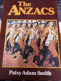
hard cover non-fiction book, The Anzacs
Author is former servicewoman.Gallipoli was the final resting place for thousands of young Australians. Death struck so fast there was no time for escape or burial. And when Gallipoli was over there was the misery of the European Campaign. Patsy Adam-Smith read over 8000 diaries and letters to write her acclaimed best-seller about the First World War. These are the extraordinary experiences of ordinary men – and they strike to the heart. The Anzacs remains unrivalled as the classic account of Australia's involvement in the First World War.hard cover non fiction book with photos and diagrams -
 Mrs Aeneas Gunn Memorial Library
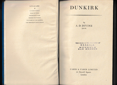
Book, Faber & Faber limited, Dunkirk, 1945
This is the story of Dunkirk and of the men who planned it (insofar as it was planned) and of the men who carried it out, and of their ships. Mr Divine, who was himself with the small boats, writes with the authority of direct knowledge. He had the assistance of the men who were intimately concerned with planning and organising the operation. This is the true story of Dunkirk from its almost nebulous beginnings to the astonishing triumph of its end. Originally published in 1945, this is the best contemporaneous account, detailing all the big and little ships that rescued the men trapped on the beaches in late May 1940.Map, p.307.non-fictionThis is the story of Dunkirk and of the men who planned it (insofar as it was planned) and of the men who carried it out, and of their ships. Mr Divine, who was himself with the small boats, writes with the authority of direct knowledge. He had the assistance of the men who were intimately concerned with planning and organising the operation. This is the true story of Dunkirk from its almost nebulous beginnings to the astonishing triumph of its end. Originally published in 1945, this is the best contemporaneous account, detailing all the big and little ships that rescued the men trapped on the beaches in late May 1940. world war 1939-1945 - naval operations - britain, operation dynamo -
 Royal District Nursing Service (now known as Bolton Clarke)
Photograph - Photograph, sepia, c.1920
A public appeal was made to raise funds for Melbourne District Nursing Society (MDNS) so motor cars could be purchased to assist their Trained nurses, known as 'Nurse' in those days, with their visits during the Spanish Influenza epidemic of 1919. With donations from businesses and individuals four cars were available within a month, and this photograph shows two of them In 1919 parked outside 'Floraston', 39 Victoria Parade, Collingwood, which was the first MDNS Headquarters and Nursing Home purchased by the Society. The MDNS uniform was a grey cotton frock with white collar, a grey coat with lapels, and a grey brimmed hat with a red Maltese cross in the centre of the hatband. From its founding in 1885 until 1891 the Trained nurses, known as 'Nurse' in those days, of the Melbourne District Nursing Society (MDNS) worked from their own homes which were located in the vicinity of their areas (districts). In November 1891 MDNS was able to rent a two story terraced house at 66 Cardigan Street, Carlton, at £65 a year, which contained accommodation for three Nurses and one pupil nurse as well as being used as their Headquarters. They left from their Nurses Home each morning and returned at the end of their shift to write up their book work before retiring for the day. Three years later they moved into a larger terraced house at 49 Drummond Street Carlton which was rented at ‘a very moderate rental’. There was a Board room, apartments for the Nurses and pupil nurse, a large dispensary which patients could attend each evening to have prescriptions signed and bottles refilled with ‘homely remedies’ and elixirs, which were administered to for e.g. Consumptive cases. Doctor’s prescriptions were filled at the Pharmacy. Cupboards containing donated blankets and bedclothes for needy patients were kept in this room, and it was here where the Nurses kept their nursing bags which were refilled at the end of each shift ready for any emergency and for the next day. A list of Doctors the Nurses could call was kept by the telephone. The home also had a kitchen where nourishing soup was made and distributed twice a week to the needy. Milk was also distributed when needed. In 1902 they moved into rented premises at 188 Leicester Street, Carlton and two years later, in 1904, to premises at 5 Royal Terrace, Nicholson Street, Fitzroy. They remained there for ten years. In June 1914 at last the Society had sufficient funding to purchase their own terraced premises, ‘Floraston’ 39 Victoria Parade, Collingwood which was their Headquarters and Nurses Home. In 1926 the After-Care Home for recovering patients, (later called After-Care Hospital) was built by the Society next door, running from 41-47 Victoria Parade (became No. 45); the District nurses continued to live at No. 39. District Nursing has had various modes of transport over the last 130 plus years. At first, from 1885 as Melbourne District Nursing Society (MDNS), the Nurses walked the streets and lane ways amid the slums of central Melbourne. As the Society expanded public transport was used, and bicycles were bought by the Society in 1903 and used in inner areas until 1945. During the Spanish flu epidemic, in 1919, MDNS appealed for assistance to procure Motor vehicles so the Nurses could visit an influx of cases. Through trusts, grants and donations four 'Ford 'T Model' cars were procured which enabled the Nurses to triple their visits. Through constant use the cars were in such a poor state they were sold in 1927. A Motor Auxiliary was formed in 1929 to take Trained nurses, now called 'Sisters' to patients, and some Sisters used their own cars; even a motorcycle was used by one Sister in 1933. All these forms of transport were intermingled until MDNS and, having received Royal patronage, the now named Royal District Nursing Service (RDNS) had its own full fleet of vehicles.Sepia photograph on grey mounting board depicting four Melbourne District Nursing Society (MDNS) Trained nurses (Nurses) sitting in two motor vehicles in front of Melbourne District Nursing Society Headquarters and Nurses Home. In the foreground are the two Ford Model T vehicles with their soft hoods open. Each car has four spoked wheels. A frame where a spare wheel is attached can be seen attached to the rear car's running board. A spare wheel, with white tyre, can be seen standing up resting against the middle of the front car; the lower section of the tyre is sitting on the running board. The steering wheel can be seen on the right hand side of both cars with a Nurse sitting behind it with her hands resting on the wheel. The upper part seen of the two MDNS Nurses in each car shows they are wearing grey uniform coats over their frocks, the white collars of which can be seen. They are all looking at the camera, and are wearing grey hats with a central Maltese cross on the white hatband. Behind the cars the footpath and the metal spiked fence, with a square concrete columns at either end can be seen. '39' is near the top of the left hand column and a white oblong name plate is attached to the fence. On the far right of the photograph a wooden gate runs from the column. A dark name plate is attached with the words 'Patient Entrance' / - 'Melbourne District Nursing Society -/ For Nursing the Sick Poor'. Behind this are a row of shrubs forming a hedge and behind this the two storey terrace building with its three arched arcade veranda on the ground floor and three long widows on the top floor with a veranda with a metal scrolled safety rail. The building has a flat roof with a central raised section with 'Floraston', written in capital letters on it. XJ. 13. is written in black ink on the bottom right corner of the photographPhotographer's stamp on mounting boardmelbourne district nursing society, mdns, transport, nurses home, rdns, royal district nursing service -
 Royal District Nursing Service (now known as Bolton Clarke)
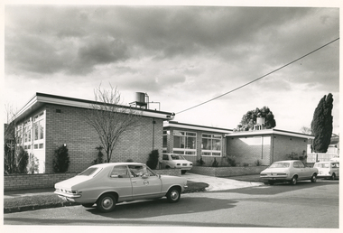
Photograph - Digital image, Barry Sutton, 12.07.1972
The photograph is taken outside the new Royal District Nursing Service (RDNS) Caulfield Centre. RDNS Sisters left in RDNS Torana vehicles from this Centre each morning to give nursing care to patients in surrounding suburbs and returned to the Centre after their visits. Gradually over the years, Melbourne District Nursing Service (MDNS), later known as Royal District Nursing Service (RDNS) from 1966 when they received Royal patronage, opened Centres throughout the Melbourne Metropolitan area and outer suburbs. In 1972 The Melbourne Centre which was conducted from RDNS Headquarters, 452 St. Kilda Road, was relocated to Caulfield and it became the Caulfield Centre. Their Trained nurses (Sisters) left from these Centres each morning to carry out their nursing visits in a specific area (district), taking any sterilized equipment needed with them. They returned at the end of the day to write up their patients nursing histories, clean and reset any equipment used ready for re-sterilization, and contact other medical and community personal as necessary. Most of the RDNS cars were housed at each Centre, only a few being driven home by a Sister. This is a black and white photograph of two RDNS two door grey Torana cars parked on the road outside a flat roof, one storey, light coloured brick building. The building is in three sections with the centre section set back. Part of the back of a white car can be seen in the driveway to the left of the set back section. Three large white framed windows can be seen along the end view of the left hand section and even larger windows are seen in the centre section. A small water tank and piping sit on a platform on the roof of both the left and right hand sections of the building. White fascia with dark trim above it edges the roof on each sections of the building. Some pencil shape type shrubs and a bare tree is seen in front of the building and a low light coloured brick fence runs across the property and down either side of the drive, with the footpath and nature strip in front of this. The back of a white car is seen on the road in the far right of the photograph and part of a wooden fence and parts of two large trees with leaves can be seen.Barry Sutton Photographer's Stamp. Quote KY 5rdns, royal district nursing service, rdns transport, rdns centre -
 Royal District Nursing Service (now known as Bolton Clarke)
Photograph - Document/Letter, 1900
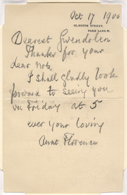
A letter dated 8th May 1973 details how the letter from Florence Nightingale was forwarded to Mrs E.G. (Janet) Wilson in 1955 by Gwendolen, Florence Nightingale's niece. The explanatory letter was forwarded by Elsa Halenstein and given to Royal District Nursing Service and remains in its Archives. From 1948 Mrs. Wilson served on the Committee of Management of Melbourne District Nursing Society (later Service), serving as President from October 1964-1967. In 1949 Mrs. Hallenstein served on the MDNS Committee of Management, becoming President of the now Royal District Nursing Service from 1967-1974. Florence Nightingale was the founder of modern nursing. Melbourne District Nursing Society (MDNS) only employed Trained nurses from its inception in 1885. They followed Florence Nightingale's basic rules of good hygiene, cleanliness, good nutrition and fresh air, which they learned during their Nursing Training at a Hospital, and taught to their patients by instruction and demonstration. In those days Trained nurses were called 'Nurse'. In 1892 MDNS employed Lucy Smith who, through the Nightingale Fund, did her nursing training at the Nightingale Training School at St. Thomas's Hospital in London. She was the first nurse from this school to work at MDNS. Florence Nightingale, born on the 12th of May 1820, was named after the place of her birth in Italy. Born into a wealthy family she was schooled at home where she excelled in her studies; spoke several languages fluently, and was taught home management. She believed she was ‘called’ to reduce human suffering and tended to ill members of her family and tenants on the family estate. She worked as a nurse at Salisbury Infirmary where she learned about nursing sanitation and hospital practice. Florence then enrolled at the Institution of Protestant Deaconesses at Kaiserswerth, Germany where she learned basic nursing skills, the importance of patient observation, and hospital organization. In 1853 she became Superintendent of the Institution for Sick Gentlewomen in Distressed Circumstances in London, where she reformed health care, working conditions, and hospital efficiency. The Crimean War broke out in late 1853 and a newspaper reported the injured and sick soldiers were being cared for by an “incompetent and ineffective medical establishment and that most basic supplies were not available for care”. After an outcry from the public, Florence was asked to lead a group of 38 nurses, whom she had trained, to Scutari where the wounded soldiers were sent. After arriving at the Barrack Hospital in October 1854, she found the soldiers were being cared for in overcrowded and filthy conditions; contaminated water, faeces on the floors and rats running freely. There were few supplies and equipment. Florence bought supplies and equipment and found help to assist in the laundry. The wards were scrubbed from floor to ceiling. Florence set a high standard of care with fresh air, hygiene, clean clothing, sufficient food and regular dressing of wounds being carried out. She realized the importance of psychological needs, and soldiers were assisted to write letters to relatives, and took part in education and recreational activities. Of a night Florence walked through the wards, carrying a lamp to light her way, to check on ill and wounded soldiers and became known as “The Lady with the Lamp”. She gained the respect of the soldiers and the establishment, and later, the public through the soldier’s letters and reports in the newspaper. After visiting Crimea she contracted ‘Crimean Fever’ from which she never really recovered. When she returned to London she was regarded a heroine. The public had given freely to buy her a gift but Florence preferred this money be used to establish a fund, which became known as the Nightingale Fund. Florence had kept excellent records on the running of the Barrack Hospital, medical and nursing staff efficiency, and the causes of illness and death. Many nurses from the training school became Matrons in many countries throughout the world. Florence pushed the Government for legislation to improve drainage and sanitation in homes and in the building of hospitals with fresh air a priority. She wrote the book ‘Notes on Nursing’ and many writings on health reform. She died, aged 90 years, in her home at 10 South Street, Park Lane on the 13th of August 1910. A handwritten letter, written in lead pencil, by Florence Nightingale. It is written to her niece Gwendolen.. The letter is on buff coloured paper and has the date 'Oct 17 1900'/ written in the top right hand corner; below this is, in capital letters, the two line black printed address - '10, South Street,/ Park Lane, W'/ is stamped. The bulk of the letter reads over eight lines: "Dearest Gwendolen",/ "Thanks for your / dear note,/ I shall gladly look / forward to seeing you, / on Friday at 5 ,/ ever your loving, / Aunt Florence./ . rdns, royal district nursing service, miss florence nightingale, mrs e.g. (janet) wilson, mrs d. (elsa) hallenstein -
 Royal District Nursing Service (now known as Bolton Clarke)
Photograph - Photograph, black and white, c.1953
Melbourne District Nursing Society (MDNS) moved into 452 St. Kilda Road, in 1953. Seven Ford Prefect cars were purchased by the Society in the early 1950s which became the beginning of a full MDNS, later called Royal District Nursing Service, fleet of cars which would be used by their District nurses to visit patients in the community over the next years.In 1875 J.B.Scott purchased Crown Land on the corner of St Kilda Road and Arthur Street. During the 1890’s an “unpretentious grey building” was built on the site. Known as ‘Airlie’, major additions were carried out during the 1920s and 30s to this historic mansion. From its founding in 1885 until 1891 the Trained nurse (Nurses) of the Melbourne District Nursing Society (MDNS) worked from their own homes which were located in the vicinity of their areas (districts). In November 1891 MDNS was able to rent a two story terraced house at 66 Cardigan Street, Carlton, at £65 a year, which contained accommodation for three Trained nurses (Nurses) and one pupil nurse as well as being used as their Headquarters. The Nurses left from there each morning and returned at the end of their shift to write up their book work before retiring for the day. Three years later they moved into a larger terraced house at 49 Drummond Street Carlton which was rented at ‘a very moderate rental’. There was a Board room, apartments for the Nurses and pupil nurses, a large dispensary which patients could attend each evening to have prescriptions signed and bottles refilled with ‘homely remedies’ and elixirs, which were administered for e.g. Consumptive cases. Doctor’s prescriptions were filled at the Pharmacy. Cupboards containing donated blankets and bedclothes for needy patients were kept in this room, and it was here where the Nurses kept their nursing bags which were refilled at the end of each shift ready for any emergency and for the next day. A list of Doctors the Nurses could call was kept by the telephone. The home also had a kitchen where nourishing soup was made and distributed twice a week to the needy. Milk was also distributed when needed. In 1902 they moved into rented premises at 188 Leicester Street, Carlton and two years later, in 1904, to premises at 5 Royal Terrace, Nicholson Street, Fitzroy. They remained there for ten years. In June 1914 at last the Society had sufficient funding to purchase their own terraced premises, ‘Floraston’ 39 Victoria Parade, Collingwood which was their Headquarters and Nurses Home. In 1926 the After-Care Home for recovering patients, (later called After-Care Hospital) was built by the Society next door to No. 39, running from 41-47 Victoria Parade (became No. 45); the District Trained nurses (Sisters) continued to live at No. 39. In 1953 ‘Airlie’ at 452 St Kilda Road was offered by the Government as part of an agreement to split the management of the Society and the After Care Hospital. On 26th November 1953 the MDNS moved its Headquarters to 452 St Kilda Road. Renovations and alterations were however restricted by limited funds so it was not until 1/12/1954 that the Hon. W. P. Barry, Minister of Health, officially opened the building. MDNS was given Royal patronage in 1966 and became Royal District Nursing Service (RDNS). In January 1983, Headquarters of the Royal District Nursing Service at 452 St Kilda Road was classified by the National Trust. The citation in support of the classification said “The house is of historical interest as the boyhood home of Stanley Melbourne Bruce, later Lord Bruce, Prime Minister of Australia from 1923-1929.” Black and white photograph of Melbourne District Nursing Society Headquarters, 452 St Kilda Road, Melbourne. The photo, taken on the corner of Arthur street, is of a two storey building and several cars and gives a unique view of St Kilda Road in the 1950s (pre high rise buildings) This large grey two storey Italian style building, has four roman column, arched Arcadia to the right of a polygon shaped bay window on the ground floor; an arched Arcade on the second floor, and three long windows above the bay window on Arthur Street. Turning the corner onto St. Kilda Road is a three arched Arcadia running towards the one window seen on the polygon shaped bay window. Arcadia is repeated on the upper storey. A balustrade is in front of the Arcadia on the upper storey and again around the flat roof. Two chimneys can be seen. A spiked metal fence runs in front of the building. To the left of this building are two white double storey buildings and some medium sized trees. On Arthur Street, two Ford Prefect cars, one with the passenger side door partly open, a Vanguard car and another make of car can be seen.royal district nursing service, headquarters, 452 st kilda road melbourne, melbourne district nursing society, mdns, mdns transport, rdns -
 Royal District Nursing Service (now known as Bolton Clarke)
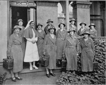
Photograph - Digital image, c.1935
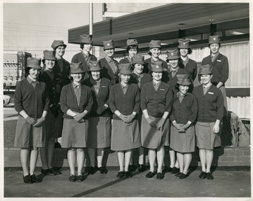
Matron F. L. Gordon and the Sisters are standing in front of the Melbourne District Nursing Society (MDNS) Nurses Home at 39 Victoria Parade, Collingwood. The Nurses lived in this residence from 1914-1953. In 1926 the After-Care Home was built next door. This image was taken twelve months after the name of the Society changed from 'Melbourne District Nursing Society After Care 'Home' to 'Hospital'. The photograph shows the uniform of the District Division of the Melbourne District Nursing Society in the 1930s, with the uniform dress made of grey cotton. Their brimmed hat was made of felt with a cotton hat band with a red Maltese cross in the centre front. From its founding in 1885 until 1891 the Trained nurses, called 'Nurse' in those days, of the Melbourne District Nursing Society (MDNS) worked from their own homes which were located in the vicinity of their areas (districts). In November 1891 MDNS was able to rent a two story terraced house at 66 Cardigan Street, Carlton, at £65 a year, which contained accommodation for three Nurses and one pupil nurse as well as being used as their Headquarters. They left from their Nurses Home each morning and returned at the end of their shift to write up their book work before retiring for the day. Three years later, in 1894, they moved into a larger terraced house at 49 Drummond Street Carlton which was rented at ‘a very moderate rental’. There was a Board room, apartments for the Nurses and pupil nurse, a large dispensary which patients could attend each evening to have prescriptions signed and bottles refilled with ‘homely remedies’ and elixirs, which were administered for e.g. Consumptive cases. Doctor’s prescriptions were filled at the Pharmacy. Cupboards containing donated blankets and bedclothes for needy patients were kept in this room, and it was here where the Nurses kept their nursing bags which were refilled at the end of each shift ready for any emergency and for the next day. A list of Doctors the Nurses could call was kept by the telephone. The Home also had a kitchen where nourishing soup was made and distributed twice a week to the needy. Milk was also distributed when needed. In 1902 they moved into rented premises at 188 Leicester Street, Carlton and two years later, in 1904, to premises at 5 Royal Terrace, Nicholson Street, Fitzroy. They remained there for ten years and an Auction of furniture was held before their next move giving an idea of some of the contents: - Carpets, linoleum, walnut and oak sideboards, dining tables, walnut dining suite, Vienna chairs, walnut bedroom suite, cedar wardrobes, chests of drawers, duchess chests, bedsteads and bedding and general furnishings were for sale. In June 1914 at last the Society had sufficient funding to purchase their own terraced premises, ‘Floraston’ 39 Victoria Parade, Collingwood which became their Headquarters and Nurses Home. In 1926 the After-Care Home for recovering patients, (later called After-Care Hospital) was built by the Society next door, running from 41-47 Victoria Parade (became No. 45); the District Sisters continued to live at No. 39. In November 1953 the District Nursing Division moved into their new Headquarters and Nurses Home at 452 St. Kilda Road, Melbourne, with a change of name to Melbourne District Nursing Service in 1957. With Royal patronage, this changed to Royal District Nursing Service (RDNS) in 1966. As District expanded, and now with outlying districts to service and with a full fleet of District cars, Sisters lived in their own homes and visited their District Centre each morning to collect their work for the day and returned there at the end of their days work in the community to carry out their administrative work. The digital image shows Matron, Miss F.L. Gordon, wearing a white uniform and veil and a dark coloured cape standing amid a group of eleven District Trained nurses (Sisters), from the Melbourne District Nursing Society (MDNS). Two Sisters are to her left and the others to her right. They are standing in front of a grey building. The Sisters are wearing their uniforms of grey long coats with lapels; the coat is secured with a belt around the waist. This is worn over their grey uniforms, with white collars. Each Sister is wearing their uniform grey brimmed hat with a Maltese cross attached to the light hatband, and are carrying a square shaped nursing case. They are standing in two rows, with some on the veranda of the building and some in front on the path; two Sisters are just off the path amid the shrubs. Part of the grey concrete building can be seen behind the Sisters with the open door to the left and part of three long windows seen to its right. One Sister has her lower left arm resting on the veranda rail.'Miss F.L. Gordon, Matron, and some of the District Sisters'mdns, melbourne district nursing society, 39 victoria parade, collingwood, rdns, royal district nursing service, nurses home, miss f.l. gordon, mdns uniforms, mdns matron -
 Royal District Nursing Service (now known as Bolton Clarke)
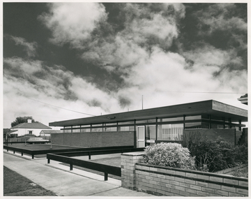
Photograph - Photograph, black and white, 30 06 1965
This photograph is a record of the Melbourne District Nursing Service (MDNS) Moorabbin Centre, situated at 611 South Road, Moorabbin. It was opened in mid 1965 and was the fourth Centre MDNS had opened. Following Royal patronage in 1966, it became known as Royal District Nursing Service (RDNS) Moorabbin Centre.Gradually over the years, Melbourne District Nursing Service, MDNS, later known as Royal District Nursing Service, RDNS, from 1966 when they received Royal patronage, opened Centres throughout the Melbourne Metropolitan area. Their Trained nurses (Sisters) left from these Centres each morning to carry out their nursing visits in a specific area, taking any sterilized equipment needed with them. They returned at the end of the day to write up their patients nursing histories, clean and reset any equipment used ready for sterilization, and to contact other medical personal as necessary. Most of the RDNS cars were housed at each Centre, only a few being driven home by a Sister.Black and white photograph of RDNS Moorabbin Centre. The building is a single story brick building with a flat roof. A row of short glass windows are seen above the brick work to the left of the large glass doors which are on the right of the building. A low standing horizontal fence is seen along the front and along either side of the path leading up to the door. Some bushes are seen in the right hand side garden of the building. A footpath can be seen in front of the fence. On the left of the photograph can be seen a white house with a pitched roof. A dark sky with fluffy white 'cumulus' clouds are seen above the buildings.Photographers stamp. Quote No. DX 18mdns, melbourne district nursing service, mdns centres, royal district nursing service, rdns -
 Royal District Nursing Service (now known as Bolton Clarke)
Photograph - Photograph, black and white, 30 08 1967
This photograph is of RDNS staff taken outside the RDNS Essendon Centre on the day of its opening on the 30th of August 1967. The RDNS Sisters are wearing their uniforms of a red cardigans over their grey cotton frocks. The opening of the RDNS Essendon Centre enabled Sisters to leave from this building to give nursing care in the community. They returned to this building at the completion of their shift.Gradually over the years, Melbourne District Nursing Service (MDNS, later known as Royal District Nursing Service (RDNS) from 1966 when they received Royal patronage, opened Centres throughout the Melbourne Metropolitan area. Their Trained nurses left from these Centres each morning to carry out their nursing visits in a specific areas (districts) taking any sterilized equipment needed with them. They returned at the end of the day to write up their patients nursing histories, clean and reset any equipment used ready for sterilization, and contact other medical personal as necessary. Most of the RDNS cars were housed at each Centre, only a few being driven home by a Sister.Black and white photograph of sixteen Royal District Nursing Service, (RDNS) staff standing in two rows outside the Essendon Centre. The Sisters are wearing uniform dark cardigans over their grey uniforms; an RDNS badge can be seen attached on the upper left hand side front of some of the cardigans. They are wearing their grey peaked uniform hats, which have a round metal silver badge with the capital letter 'RDNS' written in blue across the centre section, attached to the centre front. They are standing in front of a building, which has a flat roof with a dark fascia and below this a large windows down to a short area of brickwork. Part of a light coloured building can be seen in the background on the left hand side of the photograph.Photographers stamp. Quote No. GJ 55rdns, royal district nursing service, rdns centre, rdns uniform -
 Royal District Nursing Service (now known as Bolton Clarke)
Photograph - Photograph, black and white, 30 08 1967
The rock and attached plaque to Caroline Chisholm stand in front of the Royal District Nursing Service (RDNS) Essendon Centre. It was unveiled at the opening of the Centre on the 30 August 1967.The plaque has a deep silver colour background, light silver colour writing with gold coloured edging.Caroline Chisholm visited the goldfields of Victoria in 1854 and was horrified by the conditions en-route. The Memorial plaque to Caroline Chisholm, in front of the RDNS Essendon Centre which is situated on Crown Land, is in recognition for her work in establishing, with Government assistance, shelter sheds about a days walk apart, to enable the prospectors and their families heading for the goldfields shelter on their way. Caroline Chisholm, a Philanthropist, began her work in Madras in 1834 founding a Female School of Industry for the daughters of European soldiers. They were taught to read, write, cook, keep house and were given instructions in nursing. After coming to Sydney in 1838, she set up accommodation for poor young unemployed migrant women and families. This work was extended when she arranged employment for assisted immigrant women and families into the countryside, many times travelling with groups of young women to check their employment conditions. In seven years she placed 11,000 people in homes and employment. On her return to England she fought for, and won, free passage to Australia for wives and children of former convicts, and for children left behind in England by circumstances, when the family migrated. She established the Family Colonisation Loan Society in 1849, which set up a saving scheme for emigrants, and later loaned them half of their passage to Australia. The Society's Agents found them employment on arrival, and the loan was paid back within two years by a humane payment scheme. At first they used emigrant ships, but then the Society provided ships with much improved conditions, and this led to the upgrading of the passenger Act.. The Chisholm's lived in Kyneton for several years, returning to Sydney for health reasons, before going back to England where Caroline died, aged 68 years, on the 25th of March 1877.Black and white photograph of the Memorial plaque to Caroline Chisholm. The rectangular plaque sits on a rough light grey rock, and has light colour writing and edging, on a dark grey background. The inscription on the plaque is in five lines and reads: "On this site in the year 1855"/, "Mrs Caroline Chisholm"/, "Established a Shelter for"/, "Diggers and their families"/ "Travelling to the Goldfields"/.Photographers stamp. Quote No. GJ 56rdns, royal district nursing service, rdns centre, caroline chisholm, memorial plaque -
 Royal District Nursing Service (now known as Bolton Clarke)
Photograph - Photograph, black and white, 30 08 1967
Mrs. R. Gordon is the President of the Victorian branch of the National Council of Women. The Memorial plaque to Caroline Chisholm stands on a rock in front of the Royal District Nursing Service (RDNS) Essendon Centre, and was unveiled at the time of the opening of the Centre on the 30th of August 1967.Caroline Chisholm visited the goldfields of Victoria in 1854 and was horrified by the conditions en-route. The Memorial plaque to Caroline Chisholm, in front of the RDNS Essendon Centre, is in recognition for her work in establishing, with Government assistance, shelter sheds about a days walk apart, to enable the prospectors and their families shelter whilst heading to the goldfields. Caroline Chisholm, a Philanthropist, began her work in Madras in 1834, founding a Female School of Industry for the daughters of European soldiers. They were taught to read, write, cook, keep house and were given instructions in nursing. After coming to Sydney in 1838, she set up accommodation for poor young unemployed migrant women and families. This work was extended when she arranged employment in the countryside for assisted immigrant women and families, many times travelling with groups of young women to check their employment conditions. In seven years she placed 11,000 people in homes and employment. On her return to England she fought for, and won, free passage to Australia for wives and children of former convicts, and for children left behind in England by circumstances, when the family migrated. She established the Family Colonisation Loan Society in 1849, which set up a saving scheme for emigrants, and later loaned them half of their passage to Australia. The Society's Agents found them employment on arrival, and the loan was paid back within two years by a humane payment scheme. At first they used emigrant ships for passage, but then the Society provided ships with much improved conditions, and this led to the upgrading of the passenger Act.. The Chisholm's lived in Kyneton for several years, returning to Sydney for health reasons, before going back to England where Caroline died, aged 68 years, on the 25th of March 1877.Black and white photograph of Mrs. R, Gordon, wearing a dark coloured coat, black shoes, and a beret style white and black hat, pointing with her left hand to the unveiled Memorial plaque to Caroline Chisholm. The dark oblong plaque is adhered to a large rock.The British Flag can be seen in the foreground. Part of a building can be seen in the background; short glass windows can be seen above the brickwork on the left, with dark fascia above, and part of a large glass window to the right.Photographers stamp. Quote No. GJ 58rdns, royal district nursing service, rdns centre, essendon centre, memorial plaque, mrs r. gordon, caroline chisholm