Showing 1248 items
matching bay road
-
 Port Melbourne Historical & Preservation Society
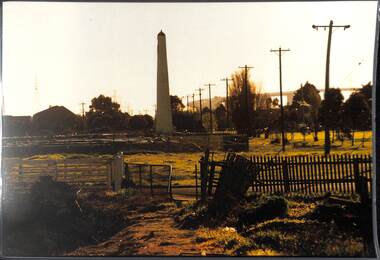
Photograph, James Lauritz, Looking towards the Beacon and Beacon Road housing, 1989 - 1990
Looking towards the Beacon and Beacon Road housing. Shows undeveloped paddocks between Beacon and the railway. Also West Gate Bridge is in the distance James LAURITZ print of Port Melbourne, laminated (one of 18). Copies of slides produced for Port Melbourne Councillocal government - city of port melbourne, built environment, james lauritz, beacon cove, beacons, engineering - bridges, west gate bridge -
 Port Melbourne Historical & Preservation Society
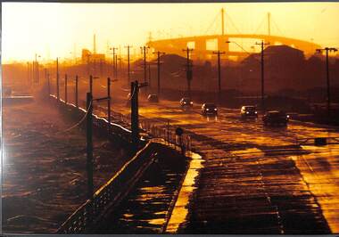
Photograph, James Lauritz, Stormy evening on Beach Rd, 1989 - 1990
Stormy evening on Beach Rd. Waves crash against the shore and West Gate Bridge in distance is very hazy James LAURITZ print of Port Melbourne, laminated (one of 18). Copies of slides produced for Port Melbourne Councilbeach road, local government - city of port melbourne, built environment, james lauritz, engineering - bridges, west gate bridge -
 Port Melbourne Historical & Preservation Society
Document - Photocopy, maps, 1890s maps, 30 April 1890 .01 11 March 1890 .02
.01 Copy of Map 3084B - Port Melbourne, Willamstown Road to Esplanade East; to Graham Street; to Boundary Road & Pickles Street. .02 Copy of map of Port Melbourne, Bay Street to Clark Street; to Foreshore; to Pickle Street & Spring Street..01 for title information see parcels index 47,53,54,55,56 & 57. .02 Parcels index 3084-B 16 (City of Port Melbourne)built environment - commercial, built environment - domestic, city of port melbourne, parish of south melbourne -
 Port Melbourne Historical & Preservation Society
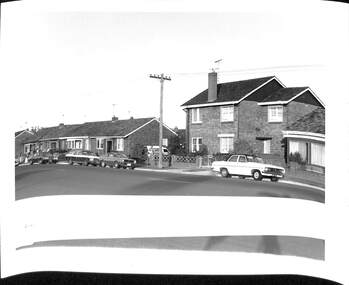
Photograph - Houses in Williamstown Road, Andrew U'REN, C. 1970s - 1980s
From a box of photographs in Nancy U'REN's papers used during research for her thesis, The Early Growth and Development of Sandridge (1976) and/or her book with Noel TURNBULL, A History of Port Melbourne (1983). The print was probably made by her son, Andrew U'REN, and he may have also taken the photograph.Black and white photograph of houses in Williamstown Road, Garden City. There is a large white border at the bottom and the top part of another image."OK" and "Williamstown rd" in blue ink on the front and type of photographic paper and exposure details on the reverse.built environment - domestic, williamstown road, garden city, nancy u'ren nee morris -
 Port Melbourne Historical & Preservation Society
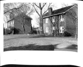
Photograph - The Quartets, Williamstown Road, Andrew U'REN, C. 1970s - 1980s
From a box of photographs in Nancy U'REN's papers used during research for her thesis, The Early Growth and Development of Sandridge (1976) and/or her book with Noel TURNBULL, A History of Port Melbourne (1983). The print was probably made by her son, Andrew U'REN, and he may have also taken the photograph.Black and white photograph of The Quartets in Williamstown Road. There is a large white border at the bottom."OK" and "Williamstown rd elderly citizens flats" in blue ink on the front. Type of photographic paper and exposure details on the reverse.built environment - domestic, williamstown road, the quartets, nancy u'ren nee morris -
Port Melbourne Historical & Preservation Society
Photograph - Proof - Port Melbourne Strong Post in St Kilda Road, waiting for the arrival of Duke and Duchess of York, The Sears Studio, 21 Apr 1927
In 1927 the Duke and Duchess of York (later King George VI and Queen Elizabeth) visited Australia. The Port Melbourne Council established a Strong Post in St Kilda Road to welcome the royal couple. Standing third and fourth from left Mrs CRICHTON, holding an Australian flag, and Cr J P CRICHTON. The tall man in centre of photograph looking at the camera is S S ANDERSON, Town Clerk. Second from right is Cr William HOWE, Mayor. This is a proof version of the final photo also held in the PMHPS collection (293.02) where the oval inset of the royal couple has been swapped from the right hand upper corner in the proof to the upper left corner in final version. Note that the price for copies of the photo is inscribed on the mount. 5/- for this (the large size) and 2/6 for a smaller size.Sepia proof photograph in a cardboard mount of Port Melbourne Council Group in St Kilda Road awaiting the arrival of Duke and Duchess of York - 21 April, 1927. A oval photo of the royal couple is inset (pasted) in the top right corner."This size 5/- each, smaller size 2/6 each" in pencil on the top left corner of the mount. "PROOF" stamped on the right edge of the mount.local government - city of port melbourne, duke of york, duchess of york, william howe, sydney sims anderson, royal visits and occasions, mayors, town clerks, james peter crichton, elizabeth branton crichton nee portbury -
 Port Melbourne Historical & Preservation Society
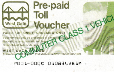
Document - Pre-paid Toll Vouchers for West Gate Bridge, 1980
From the collection of Warren DOUBLEDAY. Bridge tolls were imposed from its opening in 1978 until they were removed in 1985.Two unused white Pre-paid Toll Vouchers.' Commuter Class 1 Vehicle Only' is written in green across both the front and back, The West Gate logo is in the top left corner.transport - motor vehicles, built environment - west gate bridge, transport - roads -
Port Melbourne Historical & Preservation Society
Document - Short Road Ferry ticket, c.1974
From the collection of Warren DOUBLEDAY. The short Road ferry ran between the end of Williamstown Road in Port Melbourne across the narrowest section of the Yarra River to the bottom of the Strand in Williamstown. The name came from it being the 'short road' between the two places. There was a type of ferry service in operation from around 1873 which was modernised in the 20th century to take cars and trucks across the river. It was operated by two heavy chains which sank to the river bed to allow ships to pass.A single trip 15 cent ticket for crossing the Yarra River from Williamstown on the Short Road Ferry. The off white ticket has two diagonal blue stripes and the number F 048261 printed on the side. transport - ferries, short road ferry, williamstown, transport - motor vehicles -
Port Melbourne Historical & Preservation Society
Document - Short Road Ferry ticket, c.1974
From the collection of Warren DOUBLEDAY. The Short Road ferry ran between the end of Williamstown Road in Port Melbourne across the narrowest section of the Yarra River to the bottom of the Strand in Williamstown. The name came from it being the 'short road' between the two places. There was a type of ferry service in operation from around 1873 which was modernised in the 20th century to take cars and trucks across the river. It was operated by two heavy chains which sank to the river bed to allow ships to pass.A single trip 15 cent ticket for crossing the Yarra River from Williamstown on the Short Road Ferry. The off white ticket has two diagonal blue stripes and the number P016322 printed on the side. transport - ferries, short road ferry, williamstown, transport - motor vehicles -
Port Melbourne Historical & Preservation Society
Document - Short Road Ferry ticket 1974, 7 Jan1974
From the collection of Warren DOUBLEDAY. The Short Road ferry ran between the end of Williamstown Road in Port Melbourne across the narrowest section of the Yarra River to the bottom of the Strand in Williamstown. The name came from it being the 'short road' between the two places. There was a type of ferry service in operation from around 1873 which was modernised in the 20th century to take cars and trucks across the river. It was operated by two heavy chains which sank to the river bed to allow ships to pass.A single trip 20 cent ticket for crossing the Yarra River from Williamstown on the Short Road Ferry. The off white ticket has two diagonal blue stripes and the number C049655 printed on the side. On reverse side of ticket -" 8.25 pm trip. 7-1-74 (last East bound for day'"transport - ferries, short road ferry, williamstown, transport - motor vehicles -
Port Melbourne Historical & Preservation Society
Document - Lagoon Confectioners List and Prices of Manufactured LInes, c.1950
Lagoon Confectioners commenced manufacturing in 1921 at 118 Albert Road, South Melbourne. These included Boiled Sweets, Chocolate Novelties Counted Lines and1/2d Novelties. In 1970 they moved to premises in Graham Street, Port Melbourne. Small folded pale green pamphlet listing Lagoon Confectioners range of products and prices.lagoon confectionery pty ltd, industry - manufacturing -
 Port Melbourne Historical & Preservation Society
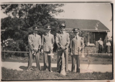
Photograph - Port Melbourne Boys band, Bill Goudie and other band members, c 1942
Bill Goudie was a member of the Port Melbourne Boys Band in the late 1930s. He is on the right of the photo (with trombone) and Harold McLeish (with cornet) is on the left. Goudie was born in 1939 and would be about 13 in the photoBill Goudie and other band members outside 236 Williamstown Roadarts and entertainment - community arts, bill goudie, harold mcleish -
 Port Melbourne Historical & Preservation Society
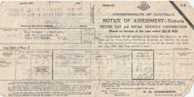
Financial record (Item) - Tax Assessment notice, Commonwealth of Australia, 16 May 1947
The 1946-7 Tax Assessment is for Mr Robert C WATTERS of 400 Williamstown Road, Port Melbourne.60189/993robert cornelius watters, finance -
 Port Melbourne Historical & Preservation Society
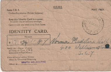
Card (Item) - Australian WW2 Identity Card, c.1940
The WW2 identity card was issued to Norma Madeline WATTERS who lived at 400 Williamstown Road, Port Melbourne and was employed at the Myer Emporium, Bourke Street , Melbourne.norma madeline watters, war - world war ii -
Port Melbourne Historical & Preservation Society
Document (Item) - Collection of documents relating to the WW2 service of Robert Watters, 1940's
A collection of documents relating to the WW2 service of Robert Cornelius WATTERS. These include the civilian identity card issued on his discharge; an application for War Gratuity; the cover for a 1941 airline ticket with Australian National Airways; a envelope addresses to M.M.A.S Melville & re-directed to 400 Williamstown Road, Port Melbourne; an envelope containing a letter addressed to H.M.A.S Lonsdale; a magazine photograph of the Boom Working vessel 'Koala'; a certificate of appreciation from the the Hon Kevin RUDD MP, Prime Minister; a 2005 card of appreciation from The Hon John HOWARD MP , Prime Minister; photocopied documents regarding his WW2 service.war - world war ii, robert cornelius watters, armed services - navy, r.a.n. reserve -
 Port Melbourne Historical & Preservation Society
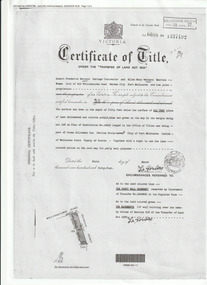
Document (Item), Certificate of Title 400 Williamstown Road, Port Melbourne, 9 Mar 1944
The Certificate of Title states that "Robert Fredrick WATTERS, Cartage Contractor and Ellen Mary WATTERS, Married Woman, both of 400 Williamstown Road, Garden City, Port Melbourne are now Joint Proprietors" of Garden City house & land on the corner of Williamstown and Beacon Roads. in 1963 Ellen became the Surviving Proprietor and 1966 the property passed to Ellen Patricia WATTERS and Norma Madeline WATTERS. Norma was registered as the Surviving Proprietor in 1984. built environment - domestic, garden city, robert fredrick watters, ellen mary watters, ellen patricia watters, norma madeline watters, williamstown road -
 Port Melbourne Historical & Preservation Society
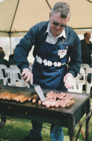
Photograph - Launch of History of a Street Precinct, 25 Sep
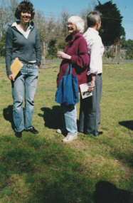
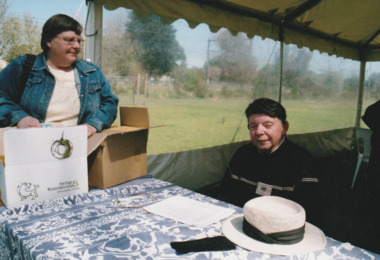
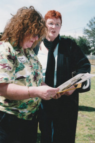
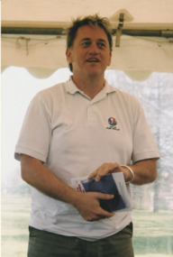
In 2005, members of the PMH&PS undertook a study of the residents of the houses in a Port Melbourne street precinct from the 1880s to 1960. The area is bounded by Evans Street, the E side of Bridge Street, S side of Williamstown Road, Farrell Street both the E & W sides plus the section of Ross Street between Farrell and Bridge and the part of Derham Street between Farrell and Bridge. The resulting map and an interactive CD won the Best Community Research, Registers & Records project at the 2007 Victorian Community History Awards. The project was launched on the railway reserve near the corner of Evans & Farrell streets. Jack BOLT is cooking with Ken TURNER in the background.Jack Bolt cooking sausages at the launch of the History of a Street Precinct25/9/05 Jack Bolt 11jack bolt, ken turner, history of a street precinct -
 Port Melbourne Historical & Preservation Society
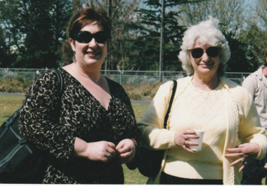
Photograph - Launch of History of a Street Precinct, 25 Sep
In 2005, members of the PMH&PS undertook a study of the residents of the houses in a Port Melbourne street precinct from the 1880s to 1960. The area is bounded by Evans Street, the E side of Bridge Street, S side of Williamstown Road, Farrell Street both the E & W sides plus the section of Ross Street between Farrell and Bridge and the part of Derham Street between Farrell and Bridge. The resulting map and an interactive CD won the Best Community Research, Registers & Records project at the 2007 Victorian Community History Awards. The project was launched on the railway reserve near the corner of Evans & Farrell streets. Liana ThOMPSON is with her mother , Fay BATES/ SHAW nee DEVINE.Liana Thompson & Fay Bates the launch of the History of a Street Precinct. 25/9/05 Liana Thompson, Fay Bates (previously Shaw nee Devine)liana thompson, fay bates, history of a street precinct -
 Port Melbourne Historical & Preservation Society
Photograph - Launch of History of a Street Precinct, 25 Sep
In 2005, members of the PMH&PS undertook a study of the residents of the houses in a Port Melbourne street precinct from the 1880s to 1960. The area is bounded by Evans Street, the E side of Bridge Street, S side of Williamstown Road, Farrell Street both the E & W sides plus the section of Ross Street between Farrell and Bridge and the part of Derham Street between Farrell and Bridge. The resulting map and an interactive CD won the Best Community Research, Registers & Records project at the 2007 Victorian Community History Awards. The project was launched on the railway reserve near the corner of Evans & Farrell streets. LL - R - unknown, Pat GRAINGER, Graham BRIDE.Pat GRAINGER, Graham BRIDE at the launch of the History of a Street Precinct project. 25/9/05 Not Known, Pat Grainger, Graham Bridepat grainger, graham bride, history of a street precinct -
 Port Melbourne Historical & Preservation Society
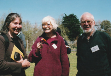
Photograph - Launch of History of a Street Precinct, 25 Sep
In 2005, members of the PMH&PS undertook a study of the residents of the houses in a Port Melbourne street precinct from the 1880s to 1960. The area is bounded by Evans Street, the E side of Bridge Street, S side of Williamstown Road, Farrell Street both the E & W sides plus the section of Ross Street between Farrell and Bridge and the part of Derham Street between Farrell and Bridge. The resulting map and an interactive CD won the Best Community Research, Registers & Records project at the 2007 Victorian Community History Awards. The project was launched on the railway reserve near the corner of Evans & Farrell streets. L- R - Natica SCHROEDER, Pat GRAINGER, Janet BOLITHO.Three members of the PMHPS the launch of the History of a Street Precinct25/9/05 Natica Schroeder, Pat Grainger, Janet Bolithohistory of a street precinct, pat grainger, natica schroeder, janet bolitho -
 Port Melbourne Historical & Preservation Society
Photograph - Launch of History of a Street Precinct, 25 Sep
In 2005, members of the PMH&PS undertook a study of the residents of the houses in a Port Melbourne street precinct from the 1880s to 1960. The area is bounded by Evans Street, the E side of Bridge Street, S side of Williamstown Road, Farrell Street both the E & W sides plus the section of Ross Street between Farrell and Bridge and the part of Derham Street between Farrell and Bridge. The resulting map and an interactive CD won the Best Community Research, Registers & Records project at the 2007 Victorian Community History Awards. The project was launched on the railway reserve near the corner of Evans & Farrell streets. L- R - Val POWER, Jim POWER.Two members of the PMHPS the launch of the History of a Street Precinct25/9/05 Val Power, Jim Powerhistory of a street precinct, val power, jim power -
 Port Melbourne Historical & Preservation Society
Photograph - Launch of History of a Street Precinct, 25 Sep
In 2005, members of the PMH&PS undertook a study of the residents of the houses in a Port Melbourne street precinct from the 1880s to 1960. The area is bounded by Evans Street, the E side of Bridge Street, S side of Williamstown Road, Farrell Street both the E & W sides plus the section of Ross Street between Farrell and Bridge and the part of Derham Street between Farrell and Bridge. The resulting map and an interactive CD won the Best Community Research, Registers & Records project at the 2007 Victorian Community History Awards. The project was launched on the railway reserve near the corner of Evans & Farrell streets. L- R - Robyn ?, Maralyn KOBELTMaralyn & Robin at the launch of the History of a Street Precinct25/9/05 Robyn ?, Maralyn Kobelthistory of a street precinct, maralyn kobelt -
 Port Melbourne Historical & Preservation Society
Photograph - Launch of History of a Street Precinct, 25 Sep
In 2005, members of the PMH&PS undertook a study of the residents of the houses in a Port Melbourne street precinct from the 1880s to 1960. The area is bounded by Evans Street, the E side of Bridge Street, S side of Williamstown Road, Farrell Street both the E & W sides plus the section of Ross Street between Farrell and Bridge and the part of Derham Street between Farrell and Bridge. The resulting map and an interactive CD won the Best Community Research, Registers & Records project at the 2007 Victorian Community History Awards. The project was launched on the railway reserve near the corner of Evans & Farrell streets. Darren Ray, Mayor of City of Port Phillip.City of Port Phillip mayor, Cr Darren Ray at the launch of the History of a Street Precinct25/9/05 Darren Ray Mayor CoPPhistory of a street precinct, darren ray -
 Port Melbourne Historical & Preservation Society
Photograph - Launch of History of a Street Precinct, 25 Sep
In 2005, members of the PMH&PS undertook a study of the residents of the houses in a Port Melbourne street precinct from the 1880s to 1960. The area is bounded by Evans Street, the E side of Bridge Street, S side of Williamstown Road, Farrell Street both the E & W sides plus the section of Ross Street between Farrell and Bridge and the part of Derham Street between Farrell and Bridge. The resulting map and an interactive CD won the Best Community Research, Registers & Records project at the 2007 Victorian Community History Awards. The project was launched on the railway reserve near the corner of Evans & Farrell streets. Janet BOLITHO, former mayor of City of Port Phillip.Former City of Port Phillip mayor, Janet Bolitho, at the launch of the History of a Street Precinct25/9/05 Janet Bolithohistory of a street precinct, janet bolitho -
 Port Melbourne Historical & Preservation Society
Photograph - Launch of History of a Street Precinct, 25 Sep
In 2005, members of the PMH&PS undertook a study of the residents of the houses in a Port Melbourne street precinct from the 1880s to 1960. The area is bounded by Evans Street, the E side of Bridge Street, S side of Williamstown Road, Farrell Street both the E & W sides plus the section of Ross Street between Farrell and Bridge and the part of Derham Street between Farrell and Bridge. The resulting map and an interactive CD won the Best Community Research, Registers & Records project at the 2007 Victorian Community History Awards. The project was launched on the railway reserve near the corner of Evans & Farrell streets. Co-author Graham BRIDE.Co-author, Graham Bride, at the launch of the History of a Street Precinct25/9/05 Graham Bridehistory of a street precinct, graham bride -
 Port Melbourne Historical & Preservation Society
Photograph - Launch of History of a Street Precinct, 25 Sep
In 2005, members of the PMH&PS undertook a study of the residents of the houses in a Port Melbourne street precinct from the 1880s to 1960. The area is bounded by Evans Street, the E side of Bridge Street, S side of Williamstown Road, Farrell Street both the E & W sides plus the section of Ross Street between Farrell and Bridge and the part of Derham Street between Farrell and Bridge. The resulting map and an interactive CD won the Best Community Research, Registers & Records project at the 2007 Victorian Community History Awards. The project was launched on the railway reserve near the corner of Evans & Farrell streets. L - R - Unknown, Norah HOWARD, Mayor Darren RAY.CoPP mayor and PMHPS members at the launch of the History of a Street Precinct25/9/05 Not known, Norah Howard, Darren Ray, Mayorhistory of a street precinct, darren ray, norma howard -
 Port Melbourne Historical & Preservation Society
Photograph - Launch of History of a Street Precinct, 25 Sep
In 2005, members of the PMH&PS undertook a study of the residents of the houses in a Port Melbourne street precinct from the 1880s to 1960. The area is bounded by Evans Street, the E side of Bridge Street, S side of Williamstown Road, Farrell Street both the E & W sides plus the section of Ross Street between Farrell and Bridge and the part of Derham Street between Farrell and Bridge. The resulting map and an interactive CD won the Best Community Research, Registers & Records project at the 2007 Victorian Community History Awards. The project was launched on the railway reserve near the corner of Evans & Farrell streets. l - R - Mayor Darren RAY, David THOMPSON, Margaret BRIDE, Janet BOLITHO, Graham BRIDE.CoPP mayor and PMHPS members involved in the production at the launch of the History of a Street Precinct25/9/05 Mayor, David Thompson, Margaret Bride, Janet Bolitho, Graham Bridehistory of a street precinct, darren ray, graham bride, margaret bride, janet bolitho, david thompson -
 Port Melbourne Historical & Preservation Society
Photograph - Launch of History of a Street Precinct, 25 Sep
In 2005, members of the PMH&PS undertook a study of the residents of the houses in a Port Melbourne street precinct from the 1880s to 1960. The area is bounded by Evans Street, the E side of Bridge Street, S side of Williamstown Road, Farrell Street both the E & W sides plus the section of Ross Street between Farrell and Bridge and the part of Derham Street between Farrell and Bridge. The resulting map and an interactive CD won the Best Community Research, Registers & Records project at the 2007 Victorian Community History Awards. The project was launched on the railway reserve near the corner of Evans & Farrell streets. L - R - Unknown, Janet BOLITHO, Glen STUART.CoPP mayor and PMHPS members at the launch of the History of a Street Precinct25/9/05 Not known, Janet Bolitho, Glen Stuarthistory of a street precinct, janet bolitho, glen stuart -
Port Melbourne Historical & Preservation Society
Photograph - Garrett Gerald TAAFE, c.1925
Garrett Gerald TAAFE (nicknamed 'Son'), trained, drove and rode Trotters and Pacers. The TAAFE family included his wife Martha TAAFE nee GILMORE, her sister, Ellen 'Nell' VALE, and Mary Genevieve VALE, Bridget BENNETT nee TAAFE, Aileen CAMPBELL nee TAAFE. Gerald died in 1935 aged 53 and his wife, Martha died in 1974 aged 92. They lived at 34 Williamstown Road, Port Melbourne.Digital photograph of Garrett Gerald 'Son" TAAFE in his riding silks with a horse.mary genevieve vale, bridget bennett nee taafe, aileen campbell nee taafe, ellen 'nell' vale, mary taafe nee gilmore, garrett gerald taafe -
Port Melbourne Historical & Preservation Society
Photograph - Malcolm Moore advertising, c.1960
Malcolm Moore Engineering Works Pty Ltd was established in Williamstown Road, Port Melbourne in 1927.Digital image of advertising for Malcolm Moore Engineering Works.malcolm moore pty ltd