Showing 2047 items
matching building and construction
-
 Federation University Historical Collection
Photographs - 5 black and white, Ballarat Junior Technical School Social Function - 1975, 1975
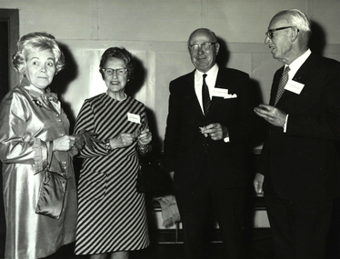
On 28 March 1981 the Ballarat College of Advanced Education 1870 Founders hall was opened. The hall was erected from the proceeds of the Centenary Appeal, held in 1975. It cost approximately $800,000. The hall commemorates the initiative of the founders of the original Ballarat School of Mines and its "descendants", including Ballarat College of Advanced Education, as well as formal technical education in Australia. The hall plans were to erect a building to accommodate 670 persons in a theatre type seating arrangement and to be used for multi-purpose use by community groups as well as by the College. Construction of the hall commenced in 1978. It was opened approximately 110 years after the Ballarat School of Mines (26 October 1870) and 10 years after the opening of the Mt Helen Campus (31 October 1870)..1) Morgan B. John on left with Bill North right. .2) L to R:- Betty Barrell; W.J.North; John Vernon; A.C.Burrow; Mrs North; Dulcie Burrow; Mrs Webb; K.C.Webb; Geoffrey Barrell .3) L to R:- unidentified; E.J. Tippett; Bert Stohr .4) L to R:- Mrs Handford-Stevens; Mrs Nicholson; J Handford-Stevens; Sir A Nicholson, Mayor of Ballarat .5) L to R:- Bill North; unidentified; S Martin-Brown; unidentifiedPhotographer's stamp on back of each photograph. .1) In pencil: "at Centenary Appeal conclusion reception 1975"; "M.B.John, President of (BIAE crossed out) SMB Council; W.J.C.(Bill) North, appeal committee chairman"; 10 - 3. .2) 10 - 4 .3) 10 - 2 .4) 10 - 1 .5) 10 - 5 a.w. nicholson, e.j. tippett, m.b. john, morgan b. john, ballarat junior technical school, ballarat school of mines, ballarat college of advanced education, 1870 founders hall, centenary appeal, 1978, 1981 -
 Federation University Historical Collection
Booklet, Berry Anderson & Co, The School of Mines and Industries, Calendar, 1914, 1913
Contents of the Booklet: Associateship, Calendar, Certificate Courses - Science, Certificate Courses - Art, Draughtsman's Courses, Discipline, Discipline Board, Examination Results, Fees, Full Certificates Issued, General Regulations, Introduction, Junior Technical School, Railway Fares, Teaching Staff, Technical Art and Craft School, Subjects of Instruction - Department of Chemistry and Metallurgy, Geological Department, Engineering Department, Electrical and Electrical Engineering Department, Department of Mathematics, Department of Physics, Electrical Wiring, Electrical Engineering for Post Office Mechanics, Turning, Fitting and Blacksmithing, Telegraphy, Art and Applied Art Subjects, Architecture and Building Construction, Engineering Drawing, Carpentry and Manual Training, Dressmaking and Dresscutting, House Decoration and Signwriting, Photography, Plumbing, Sheet Metal Working Blue covered 176 page booklet relating to the School of Mines and Industries in the year 1914. school of mines and industries, william poole, professor a. mica smith, daniel walker, hubert r. murphy, a. e. c. kerr, e. j. a. mcconnon, john m. sutherland, ralph williams, e. gutheil, t. wlliams, herbert h. smith, a. m. lilburne, m. c. young, h. j. hall, d. t. johnson, e. j. cannon, g. clegg, c. e. campbell, w. j. hall, w. h. steane, j. wright, s. h. hodder, w. j. patterson, h. w. malin, r. v. maddison, science department, associate courses, certificate courses, technical art and craft department, associated trade classes, sir redmond barry, judge rogers, r m. serjeant, thomas bath, e. ballhausen, dr stewart, james oddie, associateship and final certificates, mining engineering course, metallurgy course, applied chemistry course, irrigation engineering course, certificate courses, geology course, electrical engineering course, municipal and hydraulic engineering course, chemistry, agricultural chemistry, technical chemistry, engineering chemistry, physical chemistry, metallurgy, assaying, minerology, petrology, engineering and mining department, turning and fitting, mining, electricity, electrical technology, graphical algebra and analytical geometry, physics, mechanics and heat, sound and light, technical, art, craft and trade schools, teachers' certificates, drawing, modelling, ballarat junior technical school, full certificates issued, examination results - 1910, 1911, 1912 -
 Churchill Island Heritage Farm
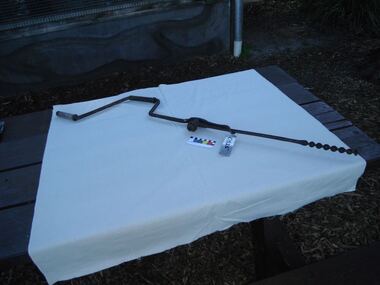
Tool - Brace and auger bit for fencing
Brace and eyed auger bits were used for boring deep holes into timber, providing space for mechanical fasteners, such as bolts or spikes. Made of iron, the pictured tool comprises a Jennings type, double twist auger bit with a threaded point to draw the bit into the wood. The other end of the shank is shaped as an eye and fitted to a hand brace. Sometimes simple cross-bars were used instead of a brace. The eye design provides greater strength than a standard auger bit. This tool’s cradle further secures the bit, preventing unwanted twisting during use. Since the late 1800’s, brace and eyed auger bits such as this were used for boring holes in fence posts, bridge building and other heavy construction.Bit bolted on and held with hook. Brace probably blacksmith made. Bit commercially made. May have been used vertically. Surface pitted.auger, fencing, brace, blacksmith, tool, tools, farm, farming, churchill island -
Unions Ballarat
Framework of flesh : Builders' Labourers battle for health and safety, McQueen, Humphrey, 2009
An oral history. "McQueen uses labourers' own words to retell their battles around scaffolding and shithouses, for the safe removal of asbestos, prompt and adequate compensation, and a decent burial. The stories start in convict times and cover the six states and the ACT. The labourers' struggle for health and safety is followed into their dismantling of the framework of fear erected by the Building and Construction Commission. By tracking on-the-job experiences of demolishers, dog-men, hod-carriers and navvies, McQueen confirms the conviction of an early official of the BLF, Ben Mulvogue: "A union constitutes a school for the working class, wherein they learn self-reliance, learn their rights, privileges, opportunities, as well as their possibilities. Every new demand for better physical protection of the workers ensures a great ideal development for a future generation.'"--Publisher's website. Relevant to the history of health and safety in the building industry and the building unions.Paper; book.Front cover: author's name and title.btlc, ballarat trades hall, ballarat trades and labour council, oh&s, occupational health and safety, workers health, building workers, unions, history, oral history -
Federation University Historical Collection
Poster, Architectural Teaching Aid
Architectural drawings on heavy card. .1 - Parallel of the Corinthian Order .2 - Greek Ionic order of Eleusis .3 - Parallel of the Greek Doric Order - plate 2 .4 - The compsite order of Palladio - plate 20 .5 - Ionic order of the theatre og Marcellus Rome - plate 8 .6 - Parallel of the orders - plate 23 .7 - The Ionic order of the Vignoles - plate 10 .8 - Roman ornament in relief - plate 25 .9 - Choragic Monument of Lysierates - plate 13 .10 - Doric Order of Virginia .11 Selling out of the ionic volute .12 - Parallel of the Greek Ionic Order - plate 6 .12 - Building Construction = plate 33 .13 - Parallel of the Greek IOnic Order - plate 16architecture, ionic, doric -
University of Melbourne, Burnley Campus Archives
Album - Colour 35mm slides, Miscellaneous Burnley Views, 1982-1990
Collection of coloured slides, all from different collections. (1) View from Luffmann Ponds to Administration Building Aug 1981. (2) Construction of Sunken Garden Nov 1982. (3) Mrs Luffmann instructing female students (see other entries used by Winzenreid.) (4) Principal's Residence (see other entries used by Winzenreid) (5) Rose garden Nov 1982. (6) Pear trees in the Quad May. (7) Student group in front of the Pavilion (see other entries used by Winzenreid) (8) Students eating watermelon (see other entries used by Winzenreid) (9) Summer House (see other entries used by Winzenreid) (10) Horticulture for Ladies (see other entries used by Winzenreid). luffmann ponds, administration building, sunken garden, mrs luffmann, female students, principal's residence, rose garden, pear trees, quad, students, pavilion, watermelon, summer house -
 Falls Creek Historical Society
Letter - Chairlift Proposal, 30.07.1962
Bob (Herman) Hymans (a former member of the Royal Netherlands Navy) was born in Bloemendaal, Holland on 30th September 1922. During World War II he fought against the Japanese in the Dutch East Indies (now Indonesia) and was imprisoned in Changi and on the Burma Railway. After gaining qualifications as a Ski Instructor, Bob arrived in Falls Creek in July 1950. Working as an Instructor and Supervisor at Bogong Lodge, Bob decided his future was in accommodation. He was successful in negotiating an indenture for land from the State Electricity Commission (SEC). It took Bob two years to build his Grand Coeur Chalet but, tragically, it was burned down in August 1961. Bob also built the first Chairlift in Australia. This was a single chairlift and the structure was built from wooden electricity poles. He was constantly full of new ideas and proposals for the village. Bob Hymans die on 7th July 2007. This Collection of documents and letters tells the story of Bob's endeavours to develop Falls Creek into the ski village it is today.This item is significant because it documents proposals put forward by Bob Hymans to develop facilities in the Falls Creek Tourist Area.This letter to the Falls Creek Tourist Area Management Committee contains Mr Hymans' application to establish one or the other of two proposals at Falls Creek. Proposal A was for the installation and operation of a double Chairlift with drive station at the top as well as the establishment and operation of an observation lounge and restaurant facilities at the top station. Proposal B was for the establishment and operation of an accommodation building. In either scheme, all patrons of the restaurant would have a panoramic view of the Valley Chairlift and every skiing slope through uninterrupted glass walls. Information regarding structure details and tariffs is included. The capital expenditure was expected to exceed £220.000 for Scheme A or £45,000 for Scheme B. Mr. Hymans proposed that construction would be scheduled for completion by the commencement of the 1963 snow season.falls creek tourist area management committee, bob hymans, falls creek administration -
Ballarat Tramway Museum
Administrative record - Memorandum, Hal Cain, moving of trams to the new depo, Dec. 1971
Copies of reports and notes prepared by Hal Cain on the moving of trams to the new depot, depot access track construction and the construction of the depot. All on foolscap sheets, toner photocopies, with punched holes on the left hand edge. 914.1 - copy of a memo on the method of moving tramcars from the old SEC Depot to the Society's new building. Written on BTPS letterhead (see item 913) over two sheets of paper. Photocopied onto a single foolscap sheet of paper. In top right hand corner has notation "written by HAL 22/12/71". Last point - number 9 did not copy well and has lost most of last line - see 914.2 (Note by WAD - basis of method used for the movement of the first tram, but found to be very difficult and likely to damage the tramcars. Led to the laying of a temporary access track to the edge of the Wendouree Parade, which was used for the movement of the following five tramcars.) 914.2 - as for 914.1 but includes good text of point 9. 914.3 - copy of a report written by Hal Cain about the "Construction of connecting track in South Gardens Reserve from the Society's Depot to Wendouree Parade". On foolscap paper, with two punch holes in the left hand edge. In top right hand corner has notation "written by HAL 22/12/71". (two copies held) 914.4 - copy of a report written by Hal Cain on the: a - quotation received by the Society for the erection of the its Tram Depot b - Formation of the BTPS Cooperative c - Progress of the Preservation Society to date. On foolscap paper, with two punch holes in the left hand edge. In top right hand corner has notation "written by HAL 22/12/71". (two copies held) trams, tramways, btps, btps depot, track construction, btps co-operative -
 Federation University Historical Collection
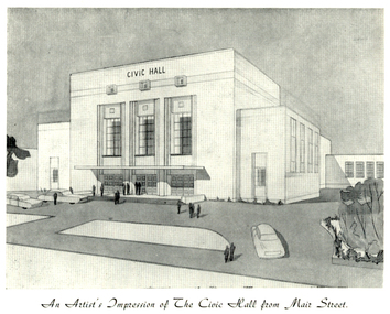
Programme, The Opening of Civic Hall, 1956, 1956
The City of Ballarat unanimously resolved to erect a Civic Hall in Mair Street in 1951. The architects, Gordon Murphy, of Melbourne, and H.L. and L.J. Coburn, of Ballarat, were commissioned in 1952. The Council constructed the foundations and footings for the building under the supervision of the former City engineer, Mr L.H. Finch, in 1953. These footings are of massed concrete. The design for the building took advantage of the cross fall of the land, providing for the Small Hall to be entered from the Doveton Street frontage through a foyer under the Main Stage, the structure is steel with brick panels, with accommodation for 1,592 persons in the Main Hall and 440 persons in the Lower Hall. The front facade faces Mair Street, set back from the building line to provide for the entrance drive-ways and kerbed gardens. Tenders were invited on a firm price basis. A young Ballarat master Builter, Walter Benbow Trahar was the successful tenderer, the contract price being 139,841 pounds. the work was commenced in 1953 and has proceeded in spite of material and labour difficulties until its completion. The following statistics are of interest:- * The foundations contained 200 cubic yards of concrete. * The constructional steel work weighs approximately 270 tons. * The reinforcing steel 47 tons. * Reinforced concrete in the structure, 1,100 cubic yards. * The approximate number of bricks in the building, 580,000. * The flooring is of selected kiln-dried hard wood and totals 40,000 lineal feet. * The dimensions of the Main Auditorium, 100ft by 86 ft, including the side promenades each 82ft by 13ft. *The Main stage, of reinforced concret with parquette finish measures 62 ft by 40ft. *The floor area of the Lower Hall is 74 ft by 38 ft, and has a stage dimensions of 40ft by 20 ft. * Each hall has independent heating and ventillating systems. Where possible the material in the building was furnished from local business houses. The public address installation, which provided for additional microphones, is on the main Stage. There is inter-communication throughout the building connecting the front office, with the bioscope box, the stages in both the large and lower halls, and the Hallkeeper's residence. Local craftsmen have completed the painting, plaster work, and the electrical installation; local produced materials being used in the construction of the buildings with the exception of the timber for the Main Floor, the roofing and the structural steel. The City of Ballarat Councillors in 1956 were Councillors N. T. Callow, F.J. Cutts, K.C. Webb, W.E. Roff, O.W. Curnow, F.T. Woodward, Allan C. Pittard, A.W. Nicholson, J.A. Chisholm, G.L. Scott, F.W. Oliver, A.D. Mason. The Town clerk was H.R. Maddern and the City Engineer was G. Murrowood. A City of Ballarat Council meeting of 25 September 2013 voted to demolish the Ballarat Civic Hall. The Council heard from nearly 50 members of the public during a marathon six-hour meeting. Councilors John Birt, Des Hudson, Amy Johnson, Josh Morris, Peter Innes, John Philips supported the motion to demolish Civic Hall. Councillors Samantha McIntosh, Vicki Coltman and Belinda Coates voted against the motion.Six page souvenir Program of citizens' entertainment on the occasion of the Opening of Ballarat Civic Hall on in August 1956. The front cover features the City of Ballarat Coat of Arms. The programme starts with a message from the Mayor, Cr Neil T. Carrow. It includes the Concert Programme directed by James H. Davey, an asrtist's impression of the Civic Hall from Mair Street, and information relative to the New Civic Hall. The programme features images of the City of Ballarat Coat of Arms, Cr N.T. Callow, , James H, Davey, and an artist's impression of the Ballarat Civic Hall. Mayor Neil Callow's Message: "To-day, our citizens witness the fulfilment of the most extensive Municipal undertaking in the City's period of recent prosperity and development. Their Hall now fills a requirement of which they have been deprived since the Coliseum building was destroyed by fire over 20 years ago. The building has been designed as an all purpose structure and I am hopeful the citizens will use it and enjoy it to its fullest extent. Your Council and its Architects have planned as broadly as possible for the benefit of all to-day and for years to come. We are proud of the work executed by a Ballaarat Master Builder whose work is a monument to the City's craftsmen. I feel I should also remind this assembly that the women of Ballaarat, back in 1951, provided funds which have been applied in the purchase of a Grand Piano and two Upright Pianos which are now installed in this building. The sincere hope of myself and your Councillors is that this Hall and its amenities will prove of immense value to the development of the cultural and artistic tastes of this community and that it will be freely used for these and many other purposes. From now on this magnificent building and its furnishings and equipment will be available to all. I strongly exhort you to use and protect it. My hope is that the citizens will, for many years to come, enjoy the amenities which it has to offer. ballarat civic hall, civic hall, architecture, finch, art deco, city of ballarat, coat of arms, city of ballarat coat of arms, callow, shugg, lemke, oates, gullan, tuuri, john, robertson, sorrell, antonio, gordon murphy, walter benbow trahar, trahar, coburn, h.l. coburn, l.j. coburn, n.t. callow -
 Orbost & District Historical Society
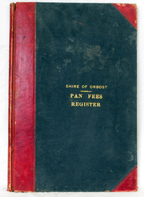
ledger, 1906
This ledger was used by the Shire of Orbost from 1906 to 1910. The item was donated to Orbost & District Historical society from P.R.O.V. as a Place of Deposit (POD) item for safe keeping by a local history group or museum. The shire covered an area of 9,347 square kilometres and existed from 1892 until 1994 when it became part of the East Gippsland Shire Council. Orbost was at first included in the Bairnsdale Shire from 1882 and was later part of the Tambo Shire. Because of travelling distances the Croajingalong Shire was created in 1892 (name changed to Orbost Shire 17.2.1893 with James Cameron as the first Shire President. In 1994 it amalgamated to become part of East Gippsland Shire Council. In Australian suburbs and rural towns where the sewer wasn't connected, people usually had an outside toilet. The toilet seat was made of a plank of wood secured at its ends to the walls of the building with a large round hole in the middle. Underneath was the removable sanitary pan and on a regular basis, usually weekly, the full pan was taken away and replaced with an empty one. This was the job of the sanitary carter. the sanitary depot was in Martins Lane, Orbost Development of the Orbost Wastewater Treatment Facility began in the 1960’s with the construction of four treatment lagoons. Shortly after the construction of the lagoons the sewerage system was installed throughout Orbost.This item is a record of accounting for the local government. The collection of sanitary pans was a necessary service before the Orbost township was had its own wastewater treatment facility.A large register of pan fees for the Shire of Orbost. A black hard cover book with red binding and marbled end pages. Entries are hand-written in black ink.On spine - "PAN FEES REGISTER: in gold lettering. In centre of front cover in gold - "SHIRE OF ORBOST (underlined) PAN FEES REGISTER"orbost-shire-council ledger-pan-fees sewage orbost-township-sanitary-service -
Glen Eira Historical Society
Document - CAULFIELD RSL
This file contains two items pertaining to the property housing the Caulfield RSL: 1/A photocopy (2 pages) of an assessment of the property, dated 01/1997, by Andrew Ward, for purposes of ascertaining its historical significance. The assessment describes the architectural features of the property, offers a brief history of it, specifies why it should be considered significant, and recommends that it be added to the National Estate Register. Included is a black-and-white photograph of the exterior of the building. 2/An assessment (17 long pages plus appendix) of the car parking issues procured as a result of the decision to refurbish the Caulfield RSL. Prepared by Grogan Richards Pty Ltd, dated 13/11/2002, reviewed by Joanna Gauetty, and authorised by Rody Jude. Included is a description of the Club’s location and surrounding motorways as they existed at the time, a description of the Club itself (eg its opening hours and rate of patronage as per each opening hour), occupancy surveys, descriptions of other recent car parking construction within the same area, a description of the extensions the RSL is aiming to construct, and descriptions of the considerations any new construction must take into account. Included is a black-and-white map of Caulfield noting the RSL’s location, and two black-and-white photographs showing the view to the north and south of St. George’s Road, respectively.caulfield, caulfield returned servicemen league (rsl), exservice organisations, clubs and associations, ward andrew, glen eira heritage management plan, historic buildings, architectural, styles, national trust company, st. leonard’s, elsternwick club, grogan richards pty ltd, returned servicepeople, armed forces, soldiers, aged people, senior citizens centres, st. george’s road, elsternwick, english domestic revival style, moderne style, brick houses, bay windows, architectural features, prendergast ellen mrs., ford grylis, dl design group, gauetty joanna, jude rody, parking, glen eira planning scheme -
 Parks Victoria - Gabo Island Lightstation
Insulator
Modern communication technologyarrived on gabo Island with the construction of the telegraph line from Eden to Gabo Island in 1870. The insulator is associated with the telegraph station. Used at the H.F Radio Beacon. The items of telegraphic equipment comprise a number of ceramic and glass insulators of varying age and type. In addition to insulators, there is a telephone insulator bracket made of metal with wooden pins. It was once attached to the top of a steel pole and some of these remain in situ along the former telegraph line (0044). Telegraphic communication commenced at the Gabo Lightstation in 1870, just eight years after the lightstation opened. The line from Sydney reached Eden, NSW by 1868 and was then extended to Gabo with the costs shared equally by NSW and Victoria. It was initially carried on posts across the sea to the island but was changed to a line along the seabed after the posts were washed away. The first telegraph office was a timber building on east side of the assistants’ quarters. In 1887 a new concrete telegraph office was built which included quarters for the operator, with Victoria and NSW sharing the construction costs. The 1992 CMP identified remnants of the line from its various phases of operation,and these were seen in 2016. Other ceramic insulators in the collection are associated with lines supported on utility poles for the transmission of high voltage electricity. The various insulators have second level significance for their historic value and provenanceFour armed cross shaped insulator with two holes through diagonally opposite sections. It is ceramic with a clear glaze. -
 Eltham District Historical Society Inc
Negative - Photograph, "The Barn", built by Jelbart, c.1945, 93 Arthur Street, Eltham, 1998c
Statement of Significance Last updated on - January 5, 2010 REVISED STATEMENT OF SIGNIFICANCE, CONTEXT, 2010 What is significant? The c1950s Jelbart residence and the c1945 barn, the garden and the gate posts and the surrounding site to the extent of the title boundaries. How is it significant? The Jelbart house and barn are historically and architecturally significant to the Shire of Nillumbik. The garden and the gate posts are historically and aesthetically significant to the Shire of Nillumbik. Why is it significant? The Jelbart house and barn are historically significant because they are unusually large and because together they comprise one of the oldest groups of substantial mud brick buildings erected during the 20th century in the Shire of Eltham and foreshadow the large mud brick residences of the 1960s and 1970s for which the area is well known (Criteria A & B). The buildings are architecturally significant because their construction (using timber post framing and mud brick walling) is a characteristic feature of what became known as the 'Eltham style'- which was prevalent in the area during the mid and latter parts of the 20th century (Criteria D & A). The garden and the gate posts - The garden is historically significant because it is a remainder of a large holding of 200 acres associated with the house (Criterion A).The gate posts are historically and aesthetically significant because they were taken from a 19th-century Toorak mansion and because their removal and re-use illustrates the practice of recycling material from demolished buildings that was one of the characteristic features of 'Eltham-style' architecture (Criteria A, D & E).Roll of 35mm colour negative film, 8 strips and associated 10 x 15 cm colour printKodak Gold 100-5arthur street, eltham, jelbart barn -
 Kew Historical Society Inc
Slide - Residences, 99 Princess Street, 1 Fellows Street, 1979
One of a group of slides taken by members of the Society of built heritage in Kew in 1979-80. The selection of subject matter reflects the priorities of the period. The colour of some slides has degraded. 99 Princes sStreet (1 Fellows Street) was built by the architects Oakden, Addison and Kemp. The Kew Conservation Study (1988) noted that: Erected By Bennie And Olivers, these Two Attached Houses Attracted An Initial Construction N.A.V. of £260. The houses were originally owned and occupied by the architect Henry Kemp, however Kemp appears not to have lived there long because, while he retained ownership for at least a decade, by 1891 George Martin, merchant and bank manager, was recorded as the tenant of No.1 Fellows Street. At that date the N.A.V. for this individual building was £83 and Kemp remained the owner of both properties until at least 1910. Kemp had arrived in Australia in 1886 and this was therefore one of the first of the many buildings he was to design in Melbourne. While late Victorian in date, the houses are of a unified design that is an interesting precursor of the Edwardian architecture produced by Kemp. Somewhat awkwardly composed with steep gables, a rectangular castellated tower and slated single storeyed verandahs projecting from the overall boxlike form, the house contains features common to the 1880s such as the use of polychromy in the brickwork and slates cladding the roof. The building departs from the norm of the time with the use of terracotta tile ridge cappings, and strapwork to the corbelled chimneys.The slides represent a snapshot in time of built architecture in Kew, much of which has changed in the forty-plus period since they were created.Colour positive transparency (slide) of the pair of residences on the corner of Princess Street and Fellows Street in Kew. The point of view is the Fellows Street frontage.comaques, historic houses -- kew (vic.), glenferrie road -- kew (vic.) -
 The Beechworth Burke Museum
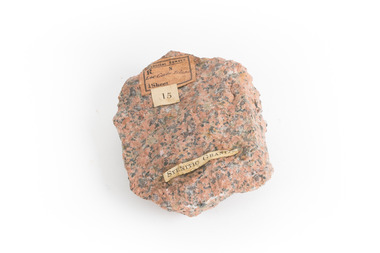
Geological specimen - Granite
Gabo Island sits off the coast of East Gippsland in Victoria, with cliffs of granite in a relatively unique red/pink colour. Early attempts to build a lighthouse on the island were abandoned due to poor foundations, but when a ship ran aground on the nearby Tullaberga Island in 1853 and led to the death of 37 people, efforts were reignited. Construction of a new lighthouse was completed by 1858, using Gabo Island granite. The lighthouse is Australia's second tallest in Australia and continues to play an important role in guiding boats around the coast as they journey between Melbourne and Sydney. The distinct pink colour from the granite means the lighthouse continues to be a defining feature of the island. Gabo Island granite was also used to construct the Treasury Building at 117 Macquarie Street in Sydney, now the Intercontinental Hotel.Granite in the pink colour of this specimen is relatively rare. The connection to the lighthouse on Gabo Island also gives the specimen historic significance and social significance regarding the maritime history of Victoria. This specimen is part of a larger collection of geological and mineral specimens collected from around Australia (and some parts of the world) and donated to the Burke Museum between 1868-1880. A large percentage of these specimens were collected in Victoria as part of the Geological Survey of Victoria that begun in 1852 (in response to the Gold Rush) to study and map the geology of Victoria. Collecting geological specimens was an important part of mapping and understanding the scientific makeup of the earth. Many of these specimens were sent to research and collecting organisations across Australia, including the Burke Museum, to educate and encourage further study.A solid palm-sized mineral, coloured by flecks of pink, red, and grey. Granite is formed by the slow crystallisation of magma below the earth's surface. It is typically composed of a mix of quartz, feldspar, and other minerals, though syenitic granite like this sample has a smaller amount of quartz than typical granite. This different mineral composition leads to the more distinct pink and red colouring.First sticker: [torn]logical survey / R........ S........ / Loc Gabo Island / 1/4 Sheet / Second Sticker: 15 Third Sticker: Syenitic Graniteburke museum, beechworth, indigo shire, beechworth museum, geological, geological specimen, mineralogy, gabo island, gabo island lighthouse, lighthouse, granite, coast, coastal, granite specimen, victoria, coastal cliffs -
 Warrnambool and District Historical Society Inc.
Financial record - Ledger: Warrnambool Water works Trust, Circa 1900
This ledger contains entries which relate to waterworks and associated expenses: construction, pumping schemes, water from stand pipes, meter rent arrears, interest payments, pumping scheme. Early residents in Warrnambool relied on tanks and wells for their water supply and in 1880 the first water supply scheme was implemented from a well on Cannon Hill. Using a windmill the water was pumped up and stored in a small reservoir nearby then piped to the corner of Timor and Liebig Streets where a stand pipe allowed the filling of water carts. Similar supplies were also installed at Albert Park, the Botanic Gardens and the Cattle markets and from 1893 to 1939 water was drawn from the Merri River. Drainage works commenced with the building of the Japan Street tunnel in 1856. The Warrnambool Waterworks Trust was the body responsible for administering these works.The supply and storage of fresh water and drainage of the area was an important factor in the development and sustainability of the town. This ledger provides an insight into the daily operations of this organisation. Large suede covered journal. Tan in colour with pink, green and white on edge of pages. Faded black stylised border around front cover. Inside front covers are patterned in green and tan. Printed sheet with Warrnambool waterworks Trust is pasted inside front cover. Warrnambool Waterworks Trust stamp on sheet inside front cover.warrnambool water works, warrnambool water supply 1900, warrnambool water works ledger 1900, warrnambool waterworks trust -
![Photograph - Digital image, Kelly Garden Supplies [Greensborough], 02/05/2013](/media/collectors/4f729f5697f83e03086015b8/items/5729bced2162f108e8de6b52/item-media/5729bd212162f108e8de74aa/item-fit-380x285.jpg) Greensborough Historical Society
Greensborough Historical SocietyPhotograph - Digital image, Kelly Garden Supplies [Greensborough], 02/05/2013
This photograph of the former site of Kelly Garden Supplies was taken in 2013 to show changes over 40 years, based on Ron Reynold’s sketches in the 1973 publication “Greensborough and Greenhills” published by Cypress Books. The site is now part of the Civic roundabout at the top of the Greensborough By-pass. Civic Drive was associated with the building of Diamond Valley Council Offices opened by Governor Rohan Delacombe on 26/2/1972. Previously it was known as Kelly's Track which wound its way around to a house that overlooked the aqueduct bridge. Kelly's Sandpit (quarry) was the local go to place to obtain road, driveway fill and red sand for local construction. For 80 years previous Kelly's quarry supplied sand to the greater Melbourne area for the surfacing of school grounds, parks etc. Digital copy of colour photograph.greensborough and greenhills, civic drive greensborough, kelly garden supplies, ron reynolds -
 Otway Districts Historical Society
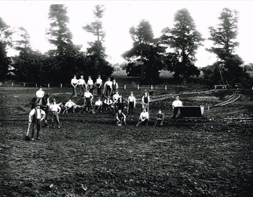
Photograph, Narrow gauge construction camp near Colac, c.1900
Construction of the Colac-Beech Forest railway line commenced in 1900 and the first activities were the work gangs and their camps. About 100 men were engaged in laying and ballasting the track while others formed the earthworks and the building of culverts and bridges. The first camp was established eight kilometres from Colac, the second 12 km south, and the remainder spaced at similar distances as the work progressed. The camps were served by butchers and bakers from Colac that visited them as many times each week to satisfy the mens' requirements. Many of the men had their families with them. They all lived in tents that consisted of a wooden floor around which the canvas cover was built. A calico partition divided the eating and sleeping quarters, and all cooking was done in camp ovens or at open fires.B/W. 158mm x 203mm. Near Colac, a narrow gauge construction camp comprising 21 workmen, a horse, and two tipping trays.construction camp; railways; colac; -
NMIT (Northern Melbourne Institute of TAFE)
DVDs: Promotional DVDs NMIT 1990-2010
Instructional and promotional DVDs ranging in date from 1990-2010 promoting courses and services of NMIT. 1990s An Introduction to NMIT 1996 X 2 Building & Construction Heidelberg 1992 Building & Construction Heidelberg 1992 1, 2, 3 (Umatic) Concrete pour - Heidelberg 1992 Greensborough Music Promotional 1994 Making the move 1996 (also booklet) NMCOT College Promotion 1990 NMCOT College promotion 1992 NMCOT Corporate Video 1992 NMCOT Corporate video 1994 NMCOT Enrolment form 1991 (Umatic) NMCOT Enrolment Form 1992 NMCOT To Market to Market Promotional video 1993 NMCOT To Market to Market Promotional video 1994 NMIT School of Arts & Social Sciences 1996 NMIT School of Building & Construction 1996 NMIT School of Business 1996 NMIT School of Electrical, Electronics & Sciences 1996 NMIT School of Horticulture & Rural Studies 1995 NMIT School of Horticulture & Rural Studies 1996 NMIT School of Manufacturing Engineering 1996 NMIT School of Mechanical Manufacturing 1996 NMIT School of Tourism & Hospitality 1996 NMIT Faculty of Earch Sciences 1998 NMIT The Electrical Connection 1995 Open Day 1992 Student Information 2003-2008 Advanced Diploma of Music Performance (undated) Challenges accepted, NMIT Roadshow 2005 Mechanical manufacturing 2003 Promotional video (master) 2006 Songwriting competition NMIT 2008 The Electrical connection 2003 2009 Animal Studies 2009 Bachelor of Viticulture & winemaking 2009 Certificate III in Aged Care 2009 Children’s Services 2009 Courses through Design Drafting & Interior Fittings 2009 X2 Equine Studies 2009 (also accompanying book) Erection and Dismantling procedure for an Oldfields Mobile Scaffold 2009 Facilitate Individual Learning Activity The REV shop Case Study 2009 Formwork to Columns and Beams 2009 Green skills Centre of Excellence : Contributing to sustainability directly through the design, our actions and by educating future generations on sustainable technology, [DVD], NMIT Epping Campus, [2009] Interior design 2009 Locksmith Apprenticeships 2009 Secondary to Tertiary: the Journey begins 2009 X 2 Visual Arts at NMIT 2009 2010 Advanced Diploma of Building design 2010 Bachelor of Accounting 2010 Bachelor of Equine Studies 2010 Certificate III in Farriery (Trade) 2010 Civil Engineering 2010 Cloisonne Enamel 2010 Conservation and Land Management 2010 Health & Community studies 2010 Horticulture 2010 How to check and adjust a single stage Liquid Petroleum Gas Regulator 2010 Locksmithing more than a trade 2010 Music, Sound & Television 2010 Pragmatic Failures in Intercultural Communication 2010 Technical Education Centre, Youth Unit, NMIT 2010 Viticulture & Winemaking 2010 Why study Community Services at NMIT 2010 courses, handbooks, nmit -
 Ballarat Tramway Museum
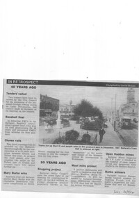
Newspaper, The Courier Ballarat, "In Retrospect", 20/09/1994 12:00:00 AM
Newspaper cutting from The Courier, Ballarat, Tuesday 20/9/1994 of the reproduction of a postcard photograph showing an ESCo tram soon after opening running west bound in Sturt St with the Town Hall in the background. Shows the development of the Gardens at the time and buildings on either side of Sturt St. and type of poles etc. The tram is fitted with a destination board on the front dash - the type used soon after opening in 1905. Caption of the photo says "Trams run up Sturt St and people relax in this postcard sent in December 1907. Ballarat's Town Hall is pictured at right." Also has an item in the "In Retrospect" section of the newspaper, about the construction of a new road to avoid two level crossings between Talbot and Clunes. Item compiled by Lorrie BrownIn bottom right hand corner, in blue ink "Tues 20/9/94".trams, tramways, sturt st, esco, town hall -
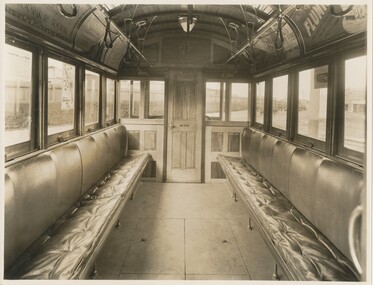 Ballarat Tramway Museum
Photograph - Black & White Photograph/s, Sutcliffe Pty Ltd, c1929
Black and white photograph of the interior a W2 end saloon showing the longitudinal seats upholstered in leather. Photo taken at Preston Workshops, shows interior fit out at the time of construction, with central strap hangers (leather), light fittings. Tram would appear to have been service for some time as it is fitted with advertisements and M&MTB posters. Destination City, 4th Edition page 42 notes that W2 329, 331, 332, 335 were fitted with leather seating in 1929. Keith Kings identified that the tram is 329 in a photo held by the Melbourne Tram Museum. Taken by Sutcliffe Pty Ltd. Photographers. Has "Sutcliffe Pty. Ltd. Photographers Cromwell buildings 366a Bourke St. Melbourne" stamp in purple on back of photo.On rear in pencil "Interior W2 upholstered in leather", "M&MTB" and "40".trams, tramways, mmtb, w2 class, upholstery, interiors, tram 329 -
 Kew Historical Society Inc
Plan, Melbourne & Metropolitan Board of Works : Borough of Kew : Detail Plan No.1569, 1905
The Melbourne and Metropolitan Board of Works (MMBW) plans were produced from the 1890s to the 1950s. They were crucial to the design and development of Melbourne's sewerage and drainage system. The plans, at a scale of 40 feet to 1 inch (1:480), provide a detailed historical record of Melbourne streetscapes and environmental features. Each plan covers one or two street blocks (roughly six streets), showing details of buildings, including garden layouts and ownership boundaries, and features such as laneways, drains, bridges, parks, municipal boundaries and other prominent landmarks as they existed at the time each plan was produced. (Source: State Library of Victoria)This plan forms part of a large group of MMBW plans and maps that was donated to the Society by the Mr Poulter, City Engineer of the City of Kew in 1989. Within this collection, thirty-five hand-coloured plans, backed with linen, are of statewide significance as they include annotations that provide details of construction materials used in buildings in the first decade of the 20th century as well as additional information about land ownership and usage. The copies in the Public Record Office Victoria and the State Library of Victoria are monochrome versions which do not denote building materials so that the maps in this collection are invaluable and unique tools for researchers and heritage consultants. A number of the plans are not held in the collection of the State Library of Victoria so they have the additional attribute of rarity.Original survey plan, issued by the MMBW to a contractor with responsibility for constructing sewers in the area identified on the plan within the Borough of Kew. The plan was at some stage hand-coloured, possibly by the contractor, but more likely by officers working in the Engineering Department of the Borough and later Town, then City of Kew. The hand-coloured sections of buildings on the plan were used to denote masonry or brick constructions (pink), weatherboard constructions (yellow), and public buildings (grey). This plan covers parts of Sackville Street, John Street, Thomas Street and Cotham Road, and includes several very large houses in Sackville Street. Job Smith built ‘Berrington’ in about 1888-90 for himself, and ‘Pomeroy’ (now ‘Merridale’) in 1885 for James Mickleburgh. ‘Heathfield’ was built in 1888 for Henry Eeles, and was one of many fine homes in Kew, Hawthorn and surrounding suburbs designed by prolific architect John Beswicke; it later became “La Verna” and was a Franciscan monastery. Similarly, in Cotham Road, we can see ‘Bella Vista’ (now demolished), and ‘Charleville’, with its double-storeyed arcade frontage, built in 1889 for Charles Donaldson whose family occupied it until 1939. This was renamed ‘Ross House’ by the second owner, Dr. Thomas King, and then substantially restored in the 1960s by the Stillwell family, well known as car drivers and dealers. Bella Vista (later ‘Malinda’) was originally designed by the architect Robert Haddon and built for Abel Hoadley, inventor of the Violet Crumble Bar and many other delicious delicacies. He began by manufacturing jams and pickles in South Melbourne using fruit from his own orchard in East Burwood.melbourne and metropolitan board of works, detail plans, mmbw 1569, cartography -
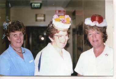 Kiewa Valley Historical Society
Photographs – Photographs of staff from Tawonga District General Hospital & Alpine Health – Set of 13 colour photographs
In the early stages of the Kiewa Hydro-Electric Scheme the State Electricity Commission took over the financial and construction responsibility of the Tawonga District General Hospital building at a cost of 27,000 pounds. This included the removal and re-erection of the ex-military Bonegilla ward from Wodonga while in addition they carried out all the necessary building works that allowed the hospital to operate as a functional unit. The work was completed and handed over to the Hospital Committee of Management on September 1, 1949. Local residents raised 3,400 pounds through fund raising. The balance was met by the SEC and the Hospital and Charities Commission. The initial project was to provide for a basic temporary hospital which was later to include an Operating Theatre, Offices, Store, Mortuary and a Nurse’s Home, until the establishment of a permanent medical premises. Following the opening, 455 patients were admitted to the Tawonga District General Hospital and 254 operations were performed in the first year. The hospital relocated to Mount Beauty in the former SEC administration offices located in the town centre. Official opening of the 18 bed Tawonga District General Hospital on April 29 in 1961. Kiewa Valley House nursing home was officially opened on March 6th, 1985, with a new lounge extension opening in May, 1993. Prior to this, residents had to travel to Beechworth, Wangaratta or Wodonga for care. The old weatherboard building was demolished around the late 1900’s to early 2000’s and replaced with a new modern brick building. Alpine Health CEO Mr Lyndon Seys oversaw the opening of the new Mount Beauty Hospital in November 2001 alongside Board of Management President Mr Andrew Randell, other board members and politicians.The Kiewa Hydro-Electric Scheme the State Electricity Commission played a pivotal part in the planning and initial funding of the Tawonga District General Hospital, with a view to providing medical support for its many workers on the Hydro scheme. Later, spouse and family members of workers were also able to access medical assistance. Many SEC workers and their families have received high medical care at Tawonga District General Hospital and Alpine Health and/or as residents of Kiewa Valley House over the years. A number of family members of SECV workers as well as other dedicated staff have provided high quality medical attention and support in all three facilities as nursing staff, support staff and volunteers. Many past staff members and their families still remain living in the Kiewa Valley area Set of 13 colour photographs of past nursing staff and support staff from Tawonga District General Hospital, Kiewa Valley House & Alpine Health 1. Marg Hickey, Barbara Clark & Margaret Ranton 2. Cheryl Clutterbuck & Rosemary Forrest 3. Margaret Ranton 4. Margaret Ranton holding unknown infant 5. Gwen Goss 6. Barbara Clark & Margaret Ranton 7. Margaret Ranton, Sue Zeinert & Jenny Piera 8. Margaret Ranton, Gloria Ryder & Jenny Piera 9. Sue Wesley, Ruth Barton, Margaret Ranton, Rosemary Forrest & Nola Henry 10. F Bogaski & H Sigmund 11. Maintenance Supervisor H Sigmund 12. Gardener Fred Keat & Handyman Joe Trezise (1977) 13. Nursing staff in new hospital 1-9 No markings 10 F Bogaski & H Sigmund 11. Maintenance Supervisor H Sigmund 12. Gardener Fred Keat & Handyman Joe Trezise (1977) 13. Nursing staff in new hospital tawonga district general hospital, kiewa valley house, alpine health -
 Eltham District Historical Society Inc
Photograph - Digital Photograph, Marguerite Marshall, Wingrove Cottage, Main Road, Eltham, 8 June 2006
Wingrove Cottage built 1858-1859 of hand made bricks is historically significant for its long association with Charles Wingrove, a prominent figure in Victorian local government, as secretary to the Eltham District Road Board and Shire Council from 1858 to 1904, and Shire Engineer and Secretary to the Heidelberg Road Board. The cottage was used as the office of the Eltham District Road Board and Council for many years It is one of the Shire's oldest dwellings, and one of the few surviving 19th century buildings associated with early Eltham and located in the original Eltham Village Reserve. The symmetrical planting of a pair of Pencil Pines (not visible in photo) is also historically and aesthetically significant as characteristic of the early period of planting in the district and because they are a distinctive landscape feature. In October 2002 new owners demolished the outbuildings attached to the rear of the cottage. Community protest at the demolition resulted in Council issuing a Stop Work order. The owner was issued with a court order in September 2003 to develop a conservation management plan and restore the heritage listed property. The owner sold the property in 2005 to Cameron Construction in 2005 who undertook the restoration work. In 2007 a planning application to build two offices and seven dwellings at the rear of the property was ultimately rejected. The cottage is now the main office for Cameron Construction. Covered under Heritage Overlay, Nillumbik Planning Scheme. Published: Nillumbik Now and Then / Marguerite Marshall 2008; photographs Alan King with Marguerite Marshall.; p57This collection of almost 130 photos about places and people within the Shire of Nillumbik, an urban and rural municipality in Melbourne's north, contributes to an understanding of the history of the Shire. Published in 2008 immediately prior to the Black Saturday bushfires of February 7, 2009, it documents sites that were impacted, and in some cases destroyed by the fires. It includes photographs taken especially for the publication, creating a unique time capsule representing the Shire in the early 21st century. It remains the most recent comprehenesive publication devoted to the Shire's history connecting local residents to the past. nillumbik now and then (marshall-king) collection, cameron construction, charles symons wingrove, eltham, eltham road district board, eltham shire council, main road, wingrove cottage -
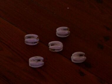 Parks Victoria - Gabo Island Lightstation
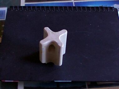
Insulators
Modern communications technology arrived on Gabo Island with the construction of the telegraph line from Eden to Gabo Island in 1870. This type of insulator was usually used with radio antennae wires, telegraph and radio antennae equipment. The items of telegraphic equipment comprise a number of ceramic and glass insulators of varying age and type. Five, knuckle-shaped white glazed ceramic examples are associated with radio antennae wires. In addition to insulators, there is a telephone insulator bracket made of metal with wooden pins. It was once attached to the top of a steel pole and some of these remain in situ along the former telegraph line. Telegraphic communication commenced at the Gabo Lightstation in 1870, just eight years after the lightstation opened. The line from Sydney reached Eden, NSW by 1868 and was then extended to Gabo with the costs shared equally by NSW and Victoria. It was initially carried on posts across the sea to the island but was changed to a line along the seabed after the posts were washed away. The first telegraph office was a timber building on east side of the assistants’ quarters. In 1887 a new concrete telegraph office was built which included quarters for the operator, with Victoria and NSW sharing the construction costs. The 1992 CMP identified remnants of the line from its various phases of operation, and these can still be seen in 2016. Other ceramic insulators in the collection are associated with lines supported on utility poles for the transmission of high voltage electricity. .The various insulators have second level significance for their historic value and provenanceFive white glazed ceramic insulators. Knuckle bone sized, oval shaped with one opening at either end. All five are the same. -
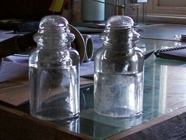 Parks Victoria - Gabo Island Lightstation
Insulators
Modern communication tecnology arrived on Gabo Island with the construction of the telegraph line from Eden to Gabo Island in 1870. These and other cylindricial insulators were associated with the original 1870 copper wire telegraph line and later the P.M.G. line. The items of telegraphic equipment comprise a number of ceramic and glass insulators of varying age and type. Two bell-shaped insulators are made of clear glass, one with remains of wooden dowel inside. In addition to insulators, there is a telephone insulator bracket made of metal with wooden pins. It was once attached to the top of a steel pole and some of theseremain in situ along the former telegraph line. Telegraphic communication commenced at the Gabo Lightstation in 1870, just eight years after the lightstation opened.The line from Sydney reached Eden, NSW by 1868 and was then extended to Gabo with the costs shared equally by NSW and Victoria. It was initially carried on posts across the sea to the island but was changed to a line along the seabed after the posts were washed away. The first telegraph office was a timber building on east side of the assistants’ quarters. In 1887 a new concrete telegraph office was built which included quarters for the operator, with Victoria and NSW sharing the construction costs. The 1992 CMP identified remnants of the line from its various phases of operation,231 and these can still be seen in 2016. Other ceramic insulators in the collection are associated with lines supported on utility poles for the transmission of high voltage electricity. The various insulators have second level significance for their historic value and provenance1. Clear glass insulator. Cyndrical bottle shape with smaller dome -like knob on top. Hollow with inscription on lower edge. Has remains of wooden dowell inside. 2.Clear glass insulator. Cyndrical bottle shape with smaller dome -like knob on top. Hollow with inscription on lower edge.Around lower edge on opposite sides,"C.C / 42" -
 Eltham District Historical Society Inc
Photograph - Digital Photograph, Alan King, Eltham Court House, 730 Main Road, Eltham, 28 December 2007
The Eltham Court House is Eltham's oldest public building. It was classified by the National Trust in 1977. In 1857 five Eltham residents petitioned the licensing magistrates of the Heidelberg district asking for better police protection, including from itinerant gold prospectors who turned to crime when their quest was unsuccessful. In response the Eltham Courthouse was constructed in 1860. Over the years it has also been used for other activities, including for electoral polling purposes, inquests, early meetings of the Eltham Roads Board and even as an overflow classroom. This type of localised solution is characteristic of the self-reliance preserved in Eltham today. The court house is an important symbol of the spirit which makes Eltham distinctive as a community. The Eltham Courthouse is historically significant because its construction was intended to emphasise the centralised control over law and order in the Colony of Victoria in the wake of the 1852 Snodgrass committee report on the Victorian police force and the resulting Police Regulation Act (1853). The nature of the Court House planning and use of architectural devices make the building's function easily interpreted. The arrangement of rooms, with public entry and clerical rooms to the rear, and the use of raised floor levels throughout these spaces to signify relative rank is easily perceived. The distinction in entries, public, magistrate and person-in-custody, and the existing court furniture enhances appreciation of this building. The Eltham Court House is one of only two intact examples in the state of this simple design with projecting entry. The building is of architectural significance because it retains intact early features. These include use of handmade bricks, simple decoration, roof trusses, timber ceiling boards, original windows, doors and associated hardware and a collection of court furniture. Additions to the court house have been done in a manner which did not interfere with the fabric of the original building. Typical cases heard before the Court of Petty Sessions included financial debt, straying livestock, theft, assault, drunkenness, public disorder, truancy, motor vehicle offences, unregistered animals and failing to have children attend school, or be vaccinated. The courthouse operated for over 120 years before it closed in 1985. In April 2021, Nillumbik Shire Council authorised restoration of the building and furnishings. The extensive works required for the total restoration of this highly valued heritage building was undertaken by Ducon Building Solutions and other specialist contractors. Covered under Heritage Overlay, Nillumbik Planning Scheme. Victorian Heritage National Trust of Australia (Victoria) State significance Published: Nillumbik Now and Then / Marguerite Marshall 2008; photographs Alan King with Marguerite Marshall.; p65This collection of almost 130 photos about places and people within the Shire of Nillumbik, an urban and rural municipality in Melbourne's north, contributes to an understanding of the history of the Shire. Published in 2008 immediately prior to the Black Saturday bushfires of February 7, 2009, it documents sites that were impacted, and in some cases destroyed by the fires. It includes photographs taken especially for the publication, creating a unique time capsule representing the Shire in the early 21st century. It remains the most recent comprehenesive publication devoted to the Shire's history connecting local residents to the past. nillumbik now and then (marshall-king) collection, eltham, eltham court house, main road -
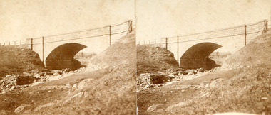 The Beechworth Burke Museum
Photograph - Stereoscopic Photograph, Unknown c1875
Depicted in the photograph is Newtown Bridge or the Newtown Falls Bridge, in Beechworth, Victoria. Noted for its location, detailed craftsmanship and stonemasonry by Scottish stonemasons the Newtown Bridge was built in the 19th century provincial town of Beechworth (completed in 1875). The bridge was built over Spring Creek, spanning 6.3 meters wide and 24.8 meters tall. Beechworth held a distinct role in the administrative and commercial management of Victoria's north-eastern goldfields, with many objects and structures still well preserved from the towns establishment. The bridge indicates the growth of the town, replacing a previous timber structure as well as its association to the mining activity in the area and the rapid increase in Australia's economy that led to investment and development of roads and railways. The local granite used in the construction of the single arch Newtown Bridge makes the bridge and other buildings made with the granite unique to the area, the honey-toned material distinct to Beechworth. This photograph is historically significant as it provides insight into the industrial development of Beechworth and the surrounding area, contributed to by the goldfields. The photograph further captures the representation of vernacular engineering traditions and Scottish stonemasonry.Two sepia-toned rectangular photographs featuring a bridge in the background printed on matte photographic paper mounted on card.Reverse: 97.2324/ Newtown Bridge/ Beechworthbridge, newtown beechworth, newtown bridge, newtown, beechworth, beechworth falls bridge, beechworth mining district, spring creek, -
 The Beechworth Burke Museum
Photograph, c.1927-1930
This image shows the Punt (a kind of small boat) that took residents of Bethanga across the Murray River before the Bethanga Bridge was built. Bethanga Bridge was built between 1927 and 1930, and was made a necessity by the building of the Hume Dam. The Hume Dam, formerly known as the Hume Weir, was in construction between 1919 and 1936, which swelled the Murray River into the floodplain to the East of the dam permanently, creating Lake Hume, and isolating the residents of Bethanga and nearby towns, for whom the trip all the way around the new lake to another river crossing was a massive undertaking. The person who wrote on the back of this card instead chose to cross the river on a boat until the Bethanga Bridge became available. Interestingly, partially submerged trees can be seen in the lake in the background of this photograph, illustrating that the dam had already begun to fill the floodplain even before the bridge was built. This photograph shows the methods the residents of Bethanga used while the Bethanga Bridge was being built. This record is associated with the Heritage Listed sites of the Hume Dam and the Bethanga Bridge, and shows the environment during the process of construction and the creation of Lake HumeSepia rectangular photograph printed on matte photographic paperReverse: 1997.3189 / 84 -19 -1 / This is the snap of the Punt. / Our only means of getting out / of Bethanga for the present / Until the bridge is completed / it is 2 miles above the junction / of the Mitta + Murray. It is / 1/2 a mile wide + runs across / the Murray into NSW / Kodak Print / bethanga, bethanga bridge, hume, hume dam, artificial lake, lake hume, hume weir, flood, floodplain, boat, punt, weir, pier, dock, transport, transportation -
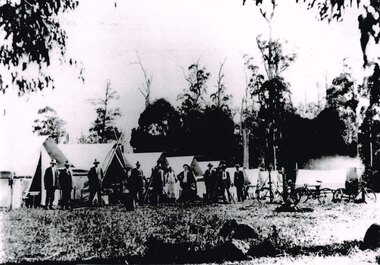 Otway Districts Historical Society
Photograph, Knox Collection, Survey camp for Colac-Beech Forest railway, 1901, 1901
Plans for a rail connection between Colac and Beech Forest had been drawn up in 1884 and 1889 but proofed inconclusive because of the enormous cost involved in building a railway in such difficult terrain. Because of the financial depression in the early 1890s such expenditure went of hold. Towards the end of the decade planners recognised that a narrow gauge could be a viable alternative and it was taken up by the community, Parliamentary representatives and the government, although Victorian Railways administration was against the idea. This was overridden. The 1898 Parliament approved a 2 foot 6 inch gauge from Colac to Beech Forest although strict financial limits were set. The route was to be the most direct and the infrastructure the most basic. Construction began in 1900 entailing very steep grades and myriad curves until it finished in 1902. Surveyors and their assistants came before and during the track laying for the whole distance.B/W. Survey camp for the Colac-Beech Forest railway in 1901, showing nine tents, ten men including a cook, survey instruments, and three bicycles. Note the cooking fire on the right.colac: beech forest; railways; survey;