Showing 1830 items
matching church buildings
-
 Kew Historical Society Inc
Plan, Melbourne & Metropolitan Board of Works : Borough of Kew : Detail Plan No.1568, 1905
The Melbourne and Metropolitan Board of Works (MMBW) plans were produced from the 1890s to the 1950s. They were crucial to the design and development of Melbourne's sewerage and drainage system. The plans, at a scale of 40 feet to 1 inch (1:480), provide a detailed historical record of Melbourne streetscapes and environmental features. Each plan covers one or two street blocks (roughly six streets), showing details of buildings, including garden layouts and ownership boundaries, and features such as laneways, drains, bridges, parks, municipal boundaries and other prominent landmarks as they existed at the time each plan was produced. (Source: State Library of Victoria)This plan forms part of a large group of MMBW plans and maps that was donated to the Society by the Mr Poulter, City Engineer of the City of Kew in 1989. Within this collection, thirty-five hand-coloured plans, backed with linen, are of statewide significance as they include annotations that provide details of construction materials used in buildings in the first decade of the 20th century as well as additional information about land ownership and usage. The copies in the Public Record Office Victoria and the State Library of Victoria are monochrome versions which do not denote building materials so that the maps in this collection are invaluable and unique tools for researchers and heritage consultants. A number of the plans are not held in the collection of the State Library of Victoria so they have the additional attribute of rarity.Original survey plan, issued by the MMBW to a contractor with responsibility for constructing sewers in the area identified on the plan within the Borough of Kew. The plan was at some stage hand-coloured, possibly by the contractor, but more likely by officers working in the Engineering Department of the Borough and later Town, then City of Kew. The hand-coloured sections of buildings on the plan were used to denote masonry or brick constructions (pink), weatherboard constructions (yellow), and public buildings (grey). Plan No.1568 covers the area bounded by Cotham Road, John Street, Sackville Street, and Edward Street. Alfred Street and Rowland Street are in shown in the middle of the plan. The two most notable buildings shown are ‘St Helliers’, the home of the Dumaresq family, and St Hilary’s Church and school. While the colours used to indicate St Hilary’s are grey as in other civic/public buildings, the first St Hilary’s Anglican Church was at this stage constructed in weatherboard. At the left of the plan, facing Sackville Street is a house named ‘Glencara’. The 1988 ‘Kew Conservation Study’ recorded that “The first documentary evidence of this house comes from Rate Books which record that in 1893 a Mrs Treadway was the owner of this building with an N.A.V. of £81? At that date the occupier of the house was Charles B. Kelly, a clerk, while by 1910 Kelly had become the owner of the property described in that year ‘as a six-roomed stone, brick and wood house with stables and outbuildings’”. Contrary to this description, the 1905 plan indicates that the house was entirely constructed of masonry.melbourne and metropolitan board of works, detail plans, mmbw 1568 -
 Kew Historical Society Inc
Plan, Melbourne & Metropolitan Board of Works : Borough of Kew : Detail Plan No.1574, 1905
The Melbourne and Metropolitan Board of Works (MMBW) plans were produced from the 1890s to the 1950s. They were crucial to the design and development of Melbourne's sewerage and drainage system. The plans, at a scale of 40 feet to 1 inch (1:480), provide a detailed historical record of Melbourne streetscapes and environmental features. Each plan covers one or two street blocks (roughly six streets), showing details of buildings, including garden layouts and ownership boundaries, and features such as laneways, drains, bridges, parks, municipal boundaries and other prominent landmarks as they existed at the time each plan was produced. (Source: State Library of Victoria)This plan forms part of a large group of MMBW plans and maps that was donated to the Society by the Mr Poulter, City Engineer of the City of Kew in 1989. Within this collection, thirty-five hand-coloured plans, backed with linen, are of statewide significance as they include annotations that provide details of construction materials used in buildings in the first decade of the 20th century as well as additional information about land ownership and usage. The copies in the Public Record Office Victoria and the State Library of Victoria are monochrome versions which do not denote building materials so that the maps in this collection are invaluable and unique tools for researchers and heritage consultants. A number of the plans are not held in the collection of the State Library of Victoria so they have the additional attribute of rarity.Original survey plan, issued by the MMBW to a contractor with responsibility for constructing sewers in the area identified on the plan within the Borough of Kew. The plan was at some stage hand-coloured, possibly by the contractor, but more likely by officers working in the Engineering Department of the Borough and later Town, then City of Kew. The hand-coloured sections of buildings on the plan were used to denote masonry or brick constructions (pink), weatherboard constructions (yellow), and public buildings (grey). This plan shows several very large houses, particularly along Glenferrie Road, and the area now occupied by Ruyton Girls’ School. ‘Tarring’ (incorrectly spelled here as ‘Karring’) was built for Henry Henty in 1872, on part of his original allotment of 20 acres, and ‘Mount View’, which retains its original building and the fountain in the front garden, is part of Ruyton’s Junior School. The most significant change to Tarring and its grounds since 1903, involve the removal of a number of the outbuildings, including a Burmese temple, bought by Henty from the Burmese Exhibit at the Great Exhibition of 1880. It is shown on the plan as a summerhouse. The two-storey mansion, on the corner of Glenferrie Road and Wellington Street, was built in 1891 by leading architect Alfred White as his own home. Having an initial N.A.V. of £160, the house was purchased by a warehouseman Henry Lister, by 1900, when the N.A.V. was recorded at £111. By the turn of the century the house was known as ‘Comaques’. By contrast, much smaller houses are shown in Scott and Byron Streets, including a tiny Mission Hall in Byron Street, which belonged to the Anglican Church from at least 1903 to 1917.melbourne and metropolitan board of works, detail plans, maps - borough of kew, mmbw 1574, cartography -
 Kew Historical Society Inc
Plan, Melbourne & Metropolitan Board of Works : Borough of Kew : Detail Plan No.1581, 1904
The Melbourne and Metropolitan Board of Works (MMBW) plans were produced from the 1890s to the 1950s. They were crucial to the design and development of Melbourne's sewerage and drainage system. The plans, at a scale of 40 feet to 1 inch (1:480), provide a detailed historical record of Melbourne streetscapes and environmental features. Each plan covers one or two street blocks (roughly six streets), showing details of buildings, including garden layouts and ownership boundaries, and features such as laneways, drains, bridges, parks, municipal boundaries and other prominent landmarks as they existed at the time each plan was produced. (Source: State Library of Victoria)This plan forms part of a large group of MMBW plans and maps that was donated to the Society by the Mr Poulter, City Engineer of the City of Kew in 1989. Within this collection, thirty-five hand-coloured plans, backed with linen, are of statewide significance as they include annotations that provide details of construction materials used in buildings in the first decade of the 20th century as well as additional information about land ownership and usage. The copies in the Public Record Office Victoria and the State Library of Victoria are monochrome versions which do not denote building materials so that the maps in this collection are invaluable and unique tools for researchers and heritage consultants. A number of the plans are not held in the collection of the State Library of Victoria so they have the additional attribute of rarity.Original survey plan, issued by the MMBW to a contractor with responsibility for constructing sewers in the area identified on the plan within the Borough of Kew. The plan was at some stage hand-coloured, possibly by the contractor, but more likely by officers working in the Engineering Department of the Borough and later Town, then City of Kew. The hand-coloured sections of buildings on the plan were used to denote masonry or brick constructions (pink), weatherboard constructions (yellow), and public buildings (grey). The streets and built structures in this plan were surveyed in 1903 and released to contractors in 1904. In addition to the designation of building types by colour, the plan includes detailed descriptions of land use and ownership. While many buildings remain from this period, a number of the buildings represented have been demolished including the original Kew Town Hall, and the Congregational and Roman Catholic churches in Walpole Street. While the mansion ‘Illapa’ in Princess Street is still extant – now part of ‘Rylands’ – the neighbouring mansion ‘Elsmere’ was demolished some decades ago. Rivalling Illapa and Elsmere in size were two mansions in Walpole Street, one named on the plan as ‘Gnarlbine’. Over time, Kew Junction and the south side of High Street have been reconfigured and widened, so that the commercial buildings on the corner of Princess and High Street no longer exist. A surprising feature of this part of central Kew to the northwest of Kew Junction is the amount of vacant land. In a number of cases, this land is noted by the contractor as used for vegetable gardens.melbourne and metropolitan board of works, detail plans, maps - borough of kew, mmbw 1581, cartography -
 Kew Historical Society Inc
Plan, Melbourne & Metropolitan Board of Works : Borough of Kew : Detail Plan No.1582, 1904
The Melbourne and Metropolitan Board of Works (MMBW) plans were produced from the 1890s to the 1950s. They were crucial to the design and development of Melbourne's sewerage and drainage system. The plans, at a scale of 40 feet to 1 inch (1:480), provide a detailed historical record of Melbourne streetscapes and environmental features. Each plan covers one or two street blocks (roughly six streets), showing details of buildings, including garden layouts and ownership boundaries, and features such as laneways, drains, bridges, parks, municipal boundaries and other prominent landmarks as they existed at the time each plan was produced. (Source: State Library of Victoria)This plan forms part of a large group of MMBW plans and maps that was donated to the Society by the Mr Poulter, City Engineer of the City of Kew in 1989. Within this collection, thirty-five hand-coloured plans, backed with linen, are of statewide significance as they include annotations that provide details of construction materials used in buildings in the first decade of the 20th century as well as additional information about land ownership and usage. The copies in the Public Record Office Victoria and the State Library of Victoria are monochrome versions which do not denote building materials so that the maps in this collection are invaluable and unique tools for researchers and heritage consultants. A number of the plans are not held in the collection of the State Library of Victoria so they have the additional attribute of rarity.Original survey plan, issued by the MMBW to a contractor with responsibility for constructing sewers in the area identified on the plan within the Borough of Kew. The plan was at some stage hand-coloured, possibly by the contractor, but more likely by officers working in the Engineering Department of the Borough and later Town, then City of Kew. The hand-coloured sections of buildings on the plan were used to denote masonry or brick constructions (pink), weatherboard constructions (yellow), and public buildings (grey). Public buildings, coloured grey on the Plan 1582 include the police station and post office, churches and schools. The earliest church school, Common School No.356 was located at the rear of the Congregational Church in Peel Street. It was constructed in 1859. The first buildings of Kew Primary School No.1075 on the other side of Peel Street were constructed in 1871. The school in 1903 only occupied a small fraction of its current site. In 1903, where the rear playground is now located, were two weatherboard and one brick villa. Trinity Grammar School was founded in 1902 and opened in the Parish Hall at the rear of Holy Trinity Anglican Church. It was not to move to its current site until 1906. The outline of the building housing the Kew Fire Brigade in the centre of the north side of Walton Street is shown but not named on the plan. Further down Pakington Street stood the two-storey Italianate mansion ‘Overton’. The home of Stanford Chapman, it was to be featured in the Imperial Institute series of bromide photographs of Victoria, Vol. 1: Homes and scenery. It was later to become a boarding house before it was later demolished.melbourne and metropolitan board of works, detail plans, maps - borough of kew, mmbw 1582, cartography -
 Kew Historical Society Inc
Plan, Melbourne & Metropolitan Board of Works : Borough of Kew : Detail Plan No.1591, 1905
The Melbourne and Metropolitan Board of Works (MMBW) plans were produced from the 1890s to the 1950s. They were crucial to the design and development of Melbourne's sewerage and drainage system. The plans, at a scale of 40 feet to 1 inch (1:480), provide a detailed historical record of Melbourne streetscapes and environmental features. Each plan covers one or two street blocks (roughly six streets), showing details of buildings, including garden layouts and ownership boundaries, and features such as laneways, drains, bridges, parks, municipal boundaries and other prominent landmarks as they existed at the time each plan was produced. (Source: State Library of Victoria)This plan forms part of a large group of MMBW plans and maps that was donated to the Society by the Mr Poulter, City Engineer of the City of Kew in 1989. Within this collection, thirty-five hand-coloured plans, backed with linen, are of statewide significance as they include annotations that provide details of construction materials used in buildings in the first decade of the 20th century as well as additional information about land ownership and usage. The copies in the Public Record Office Victoria and the State Library of Victoria are monochrome versions which do not denote building materials so that the maps in this collection are invaluable and unique tools for researchers and heritage consultants. A number of the plans are not held in the collection of the State Library of Victoria so they have the additional attribute of rarity.Original survey plan, issued by the MMBW to a contractor with responsibility for constructing sewers in the area identified on the plan within the Borough of Kew. The plan was at some stage hand-coloured, possibly by the contractor, but more likely by officers working in the Engineering Department of the Borough and later Town, then City of Kew. The hand-coloured sections of buildings on the plan were used to denote masonry or brick constructions (pink), weatherboard constructions (yellow), and public buildings (grey). That area of Kew bordered by Cotham Road, Park Hill Road, Ermington Lane (now Ermington Place), and Belmont Avenue contained some of the significant homes owned by Kew pioneers. Chief among these was ‘Park Hill’ on an enormous lot facing Park Hill Road. The Jubilee History of 1910 noted, six years after this plan was drawn, that: ‘Park Hill Road, forming the southern boundary of the cemetery, takes its name from Park Hill, the residence of Mr. Thomas Judd, who has resided there since December, 1852.’ Other named houses on the plan include ‘Ferndale’ facing Cotham Road; ‘Ermington’ adjacent to Judd’s Park Hill, facing Park Hill Road; and ‘Gilden’ and ‘Mont Belmont’ facing Belmont Avenue. Mont Belmont was designed by the architectural firm of Reed, Henderson and Smart for William George Lilley in 1887 and was completed in 1888. Lilley was Mayor of Kew in 1887-88, a Justice of the Peace and a member of the first Board of Guardians of Kew’s St. Hilary’s Church of England.melbourne and metropolitan board of works, detail plans, survey plans - borough of kew, mmbw 1591, cartography -
 Kew Historical Society Inc
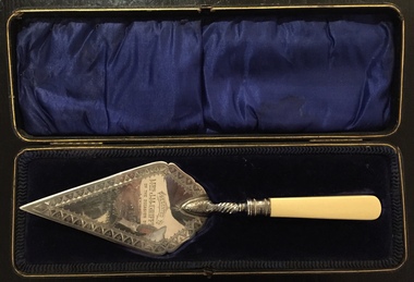
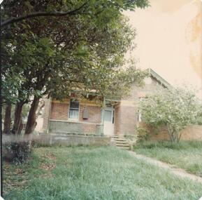
Ceremonial object - Presentation Trowel, Kew Baptist Church School Hall, Phillip Ashberry & Sons, 1905
"Infant Department The interest in this branch of the school work (under the able guidance of Misses F. Chapman and A.E. Ratten) is well maintained. It is largely through the generosity of Nr. and Mrs. Griffiths that the officers were enabled to have a new brick school hall built. The foundation stone was laid on 21st October, 1905, by Mrs. John M. Griffiths, the new building being erected on the site of the old church. It is both attractive and comfortable and is well lighted. It is also used for the week-night services. The old building which for so long had served as a schoolroom for the little ones was not considered suitable and was in 1905 disposed of for removal. When removed it was renovated, and is now used as a mission church in a neighbouring district." Source: Kew Baptist Church History 1856-1906The trowel is historically significant for its association with the Kew Baptist Church and its ownership by and association with the Griffiths family of Kew who were important tea merchants in Australia.Silver-plated commemorative trowel with bone handle, in black leather case lined with blue velvet. The trowel is engraved with information about the occasion.It was presented to Mrs J.M. Griffiths, who lived at Goldthorns, Normanby Road, Kew. [The trowel in its case was presented to the Kew Historical Society on 24 April 2018 by the Manager of Bupa Aged Care, Edithvale.]Engraved front: "Presented to Mrs. J.M. Griffiths on the occasion of her laying the foundation stone of the Baptist School Hall, Kew, Oct 21st 1905". Maker mark on reverse: "PA & S E P"griffiths family - kew (vic), mrs. j.m. griffiths, commemorative objects, baptist church (kew), presentation trowels -
 Kew Historical Society Inc
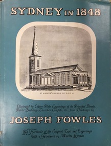
Book, Ure Smith, Sydney in 1848 : a facsimile of the original text and copper-plate engravings of its principal streets, public buildings, churches, chapels, etc, 1966
... engravings of its principal streets, public buildings, churches ...Sydney in 1848 : illustrated by copper-plate engravings of its principal streets, public buildings, churches, chapels, etc. Originally published in 20 parts in 1848-50. First published in one volume in 1878.--Publishers' note.Sydney : Ure Smith, 1966 104 p., [40 leaves] : ill. ; 29 cm. non-fictionSydney in 1848 : illustrated by copper-plate engravings of its principal streets, public buildings, churches, chapels, etc. Originally published in 20 parts in 1848-50. First published in one volume in 1878.--Publishers' note.joseph fowles, sydney - history, sydney. description & travel. early works -
 Kew Historical Society Inc
Plan - Subdivision Plan, Raheen Estate Subdivision, 1960
Subdivision plans are historically important documents used as evidence of the growth of suburbs in Australia. They frequently provide information about when the land was sold on which a built structure was subsequently constructed as well as evidence relating to surveyors and real estate and financial agents. The numerous subdivision plans in the Kew Historical Society's collection represent working documents, ranging from the initial sketches made in planning a subdivision to printed plans on which auctioneers or agents listed the prices for which individual lots were sold. In a number of cases, the reverse of a subdivision plan in the collection includes a photograph of a house that was also for sale by the agent. These photographs provide significant heritage information relating house design and decoration, fencing and household gardens.The Raheen Estate Subdivision of 1960 involved the creation of 36 residential allotments and the sale of 34 of these. The land on which the subdivision was created had until 1960 formed part of the grounds of the mansion Raheen in Studley Park Road. In 1917, the Catholic Church had purchased Raheen and its lands. It was to become the home of Archbishop of Melbourne, Daniel Mannix, for 46 years. The sale of the subdivision took place three years before the Archbishop’s death. Subsequent archbishops were to reside at Raheen until its sale to the Pratt family in 1981. When the sale of the Estate was reported in the newspapers in 1960, it was described as the last big subdivision near Melbourne. At the auction, 33 of the 36 allotments were sold. The auction realised £315,750. Purchasers were advised that the vendor intended to keep lots 22 and 23. The alllotments in the subdivision required the construction of new roads. These included Eamon Court and Raheen Drive. The justification provided by the Church for the sale was that the estate was being sold to finance school building projects.subdivision plans - kew, studley park, raheen estate, eamon court, studley park road, coombes avenue, raheen drive -
 Kew Historical Society Inc
Photograph, J E & B L Rogers, 'Ivy Grange', Malmsbury Street, c. 1965
... a fete was held at Ivy Grange in aid of building a new church... in aid of building a new church (Sacred Heart, Kew): "Garden Fete ...Rate Book evidence records that by 1870 Charles Vickers, architect, was the occupier of this house, having an NA.V. at that date o f£1105, although it is apparent that the house was in fact built by 1864, from the dat; set in the brickwork above the main door. In 1873 the property was purchased by David Beath, a merchant, and it was in the following year that the house was first recorded as 'Ivy Grange'. Beath was a deeply religious man and was a foundation member of both the Congregational and the Presbyterian (the Church of Scotland) Churches of Kew . He added, probably the tower wing, to the house in 1877 when architects Crouch and Wilson called tenders in that year 'for the erection of bluestone additions to (a) villa at Kew, for Davis Beath Esq.' The house was again added to in 1885 by the leading firm Reed, Henderson and Smart. For a number of years in the 1920s 'Ivy Grange' was used as a private mental hospital and is currently a guest house. In 1921 a fete was held at Ivy Grange in aid of building a new church (Sacred Heart, Kew): "Garden Fete in Aid of New Church, Kew. A SUCCESSFUL FUNCTION. Beautiful weather favoured the opening of a garden fete at "Ivy Grange," the residence of Mr. and Mrs. J. Lawlor, Malmsbury and Princess streets, Kew, on last Saturday afternoon, in aid of the fine new Church of the Sacred Heart, Kew, which is now receiving its finishing touches. Not content to wait for the official opening, the lady stallholders did a good business on the previous evening. The ceremony was performed" by the Very Rev. Dean Hegarty, P.P., V.F. (Carlton), with whom were associated the Rev. J. Manly, P.P. (Kew), and the Rev. R. S. Benson, P.P. (South Yarra), Mr. and Mrs. J. Lawlor, and others. Fr. Manly, who was cordially received, said he desired to thank Mr. and Mrs. Lawlor for lending their charming grounds, and for the trouble, time and expense they had given to preparing for the fete. He wished to thank Dean Hegarty for coming to open the fete. The Dean had been a dear and lifelong friend of the late Fr. O'Donoghoe, the beloved pastor of the Kew parish. Next June the Dean would celebrate the golden jubilee of his priesthood, so they could see that he was not a young man. (Laughter.) He hoped that the fete would be a great success, and that when his Grace the Archbishop —: (applause) — should open the new church, he (the speaker) would be able to present a satisfactory financial statement. (Applause.) Dean Hegarty, who was very cordially received, said it was a source of great pleasure to him to come to Kew, of which he entertained many pleasant recollections. The new church would have delighted the heart of their late beloved pastor, but it had pleased God to take him to a holler temple. His mantle had fallen on worthy shoulders, in the person of Fr. Manly—(applause)—who was carrying on the work of the parish well and vigorously. (Applause.) Some wondered how these great works were successfully accomplished. The prime factor in the wonderful progress of the Church— the work of the people, priests and nuns—was their deep, abiding Catholic faith. (Applause.) Kew was not by any means a large parish, yet look at the magnificent church that Fr. Manly was building on the hill! He said to his people, "Come, follow me, and we shall win through." (Applause.) It gave him great pleasure to declare the fete open, and he wished it the highest measure of success. (Prolonged applause.) Mr. J. Lawlor, who was greeted with applause, in moving a hearty vote of thanks to Dean Hegarty for his presence and support, said he knew of the great work done by the Dean in Gippsland, where he (the speaker) lived when a young man. The Dean ministered to a parish at that time as large as was the diocese of Sale to-day. The Dean and Fr. Manly reflected credit on the pioneer priests, who had laid well and solidly the foundations, of religion in Victoria. (Applause.) He was glad that reference had been~made to the work of their late beloved pastor, Fr. O'Donoghoe. : Mr. Pierce Cody seconded the motion, which, was carried by acclamation. The Dean,* in acknowledging the compliment, paid a tribute to Mr. and Mrs. Lawlor for their great generosity in connection with the fete, and complimented them on their successful efforts. (Applause.). A cafe chantant, organised by Mr. John. Sullivan, was contributed to by Misses G. Hornal, M. O'Donnell, Ella Burke, Eileen Burke, Alice Marsh, and M. Carrucan, and Messrs. T. Hammond, J. Donovan, J. Sullivan, and Fr. Lanigan. Mrs. J. Donovan was at the piano. St. Vincent de Paul Boys' Orphanage Band (South Melbourne) rendered selections. The stalls ware as follow:—Cake and Sweets Stall: Mesdames Needham, Treacey, Lynch and Cody. Fancy Stall: Mesdames Lawlor, J. P. Martin, M. Treacey, Simpson, Giddons and A. Molton, and Miss, Shirley. Refrestiment Stall: Mesdames Shiels, Hunter, Kealy, Duane and the Misses Turner and Delahunty; Produce Stall: Mesdames O'Sullivan, Mareli, Carrucan, and Kennedy. Mr. P. J. Kennedy acted as hon. general secretary. The fete was continued in the evening, the grounds being brilliantly illuminated. (Advocate (Melbourne, Vic. : 1868 - 1954), Thursday 7 April 1921, page 13) In 1930 it was acquired by the Carmelite Fathers for use as a novitiate: "IVY GRANGE," KEW." Acquired for Carmelite Novitiate. The valuable property, "Ivy Grange," Kew. which" belonged to the McGuiness family has been acquired by the Carmelite Fathers for a novitiate." (Advocate (Melbourne, Vic. : 1868 - 1954), Thursday 18 September 1930, page 18This work forms part of the collection assembled by the historian Dorothy Rogers, that was donated to the Kew Historical Society by her son John Rogers in 2015. The manuscripts, photographs, maps, and documents were sourced by her from both family and local collections or produced as references for her print publications. Many were directly used by Rogers in writing ‘Lovely Old Homes of Kew’ (1961) and 'A History of Kew' (1973), or the numerous articles on local history that she produced for suburban newspapers. Most of the photographs in the collection include detailed annotations in her hand. The Rogers Collection provides a comprehensive insight into the working habits of a historian in the 1960s and 1970s. Together it forms the largest privately-donated collection within the archives of the Kew Historical Society.Ivy Grange, cnr Malmsbury and Princess Streets, Kew. Ivy Grange. Home of David Beath. Commenced 1864, Tower Wing added 1877. Chap 38.ivy grange, malmsbury street, dorothy rogers, david beath, charles vickers, crouch and wilson, kew houses -
 Kew Historical Society Inc
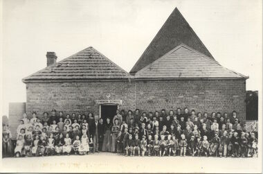
Photograph, Kew Common School, c. 1863
The Kew Common School, which had erected a new building in Peel Street only two years before the passing of the Education Act 1872, was retained and re-badged asState School No 1075, with numerous additions being made over the next few decades. This work forms part of the collection assembled by the historian Dorothy Rogers, that was donated to the Kew Historical Society by her son John Rogers in 2015. The manuscripts, photographs, maps, and documents were sourced by her from both family and local collections or produced as references for her print publications. Many were directly used by Rogers in writing ‘Lovely Old Homes of Kew’ (1961) and 'A History of Kew' (1973), or the numerous articles on local history that she produced for suburban newspapers. Most of the photographs in the collection include detailed annotations in her hand.The Rogers Collection provides a comprehensive insight into the working habits of a historian in the 1960s and 1970s. Together it forms the largest privately-donated collection within the archives of the Kew Historical Society.School photograph - The Kew Common School, located on the west side of Peel Street, Kew."Common School - Congregational Church. No.356. Photo taken early 1860s. School 356. Peel St., Rear of Congregational Church. Photo taken in early 1860s"kew common school, peel street (kew), dorothy rogers, education, kew state school -
 Kew Historical Society Inc
Journal, Kewriosity : May 1984
Bringing back the memories - in style [William Martin, Elder Care] / p1. Petrie Square / p1. Billabong Club / p2. Kew Garden Club / p2. Gone Bush! [Native Plant Group] / p2. Kew Bowling Club / p2. The Rheumatism and Arthritis Association Kew Self Help Group / p2. National Arthritis Week in Victoria / p2. Kew (Daytime) Garden Club / p2. Hockey [Kew Women's Hockey Club] / p2. Scouts / p2. May School Holiday Programme [Mobile New Trailer Games; Drop-in Centre; Kew Traffic School; Building or renovating; / p3. Kew Youth Resource Centre / p3. How Green is Our Valley - a continuing saga [S.E.C. Yarra Valley Powerlines] / p4. Mayoral Comment - Kew, its park and the SEC / Cr Jill O'Brien p5. Kew heritage [proposed heritage study] / p5. Philharmonic [Kew Philharmonic Orchestra] / p6. Kew Holiday Programme [Sacred Heart Church] / p6. The Gibbs Wathen Family re-union / p6. Yarra River Study - Dights' Falls to Burke Road / p6. Starlight Theatrical Company / p6. Kew Community House - 2nd Term Programme / p7. Public meeting - information sharing in Kew [Kewriosity Editorial Committee] / p7. Recyclotron / p7. Public Meeting - SEC Power Line / p8. Datelines [KPSA auction of pre-loved goods; A.L.P.; Guide Dogs Toastmasters Club, Kew - 100th meeting] / p8. Building? [regulations] / p8.Kewriosity was a local newsletter combining Kew Council and community news. It was published between November 1983 and June 1994, replacing an earlier Kewriosity [broad] Sheet (1979-84). In producing Kewriosity, Council aimed to provide a range of interesting and informative articles covering its deliberations and decision making, together with items of general interest and importance to the Kew community and information not generally available through daily media outlets.non-fictionBringing back the memories - in style [William Martin, Elder Care] / p1. Petrie Square / p1. Billabong Club / p2. Kew Garden Club / p2. Gone Bush! [Native Plant Group] / p2. Kew Bowling Club / p2. The Rheumatism and Arthritis Association Kew Self Help Group / p2. National Arthritis Week in Victoria / p2. Kew (Daytime) Garden Club / p2. Hockey [Kew Women's Hockey Club] / p2. Scouts / p2. May School Holiday Programme [Mobile New Trailer Games; Drop-in Centre; Kew Traffic School; Building or renovating; / p3. Kew Youth Resource Centre / p3. How Green is Our Valley - a continuing saga [S.E.C. Yarra Valley Powerlines] / p4. Mayoral Comment - Kew, its park and the SEC / Cr Jill O'Brien p5. Kew heritage [proposed heritage study] / p5. Philharmonic [Kew Philharmonic Orchestra] / p6. Kew Holiday Programme [Sacred Heart Church] / p6. The Gibbs Wathen Family re-union / p6. Yarra River Study - Dights' Falls to Burke Road / p6. Starlight Theatrical Company / p6. Kew Community House - 2nd Term Programme / p7. Public meeting - information sharing in Kew [Kewriosity Editorial Committee] / p7. Recyclotron / p7. Public Meeting - SEC Power Line / p8. Datelines [KPSA auction of pre-loved goods; A.L.P.; Guide Dogs Toastmasters Club, Kew - 100th meeting] / p8. Building? [regulations] / p8. publications -- city of kew (vic.), kewriosity, council newsletters, community newsletters -
Kew Historical Society Inc
Journal, The Kewriosity Sheet Vol.1 No.7 : December 1979
What's doing in Kew for December / p1. Kew Elder Citizens [Members; The building; Activities; The Choir; Over 80s; Opportunity Shop; Outings; Supervisor; "For Friends of the Aged"] / Gwlad Wade p1. Your news s good news / p1. Village without a name [Edgevale Road] / Barbara Giles p2. Kew Joggers Group / p2. Kinder contributes to the International Year of the Child [Davis Street Kindergarten] / p2. Christmas Church Services / p2. Australian Kite Association / Helen Bushell p2. A.R.A.F.E.M.I. - A new association for Victoria [Association of Relatives and Friends of the Emotionally and Mentally Ill] / p2. Other meetings of local interest / p2. Council News [Roadworks for the year; Municipal Offices - Access for the disabled; Parks and recreations areas; Human Services; Christmas Holiday Programme] / p2. Kew Croquet Club / p2.The Kewriosity Sheet (1979-83) was first published in the City of Kew (Victoria) in June 1979 as a two-sided 'community newssheet'. It aimed to: 'share news about Kew happenings and Kew people, and to exchange ideas about living in Kew'. Later issues gradually evolved into a 4-page, quarto sized publication. The Kewriosity Sheet was superseded by the Kew Council publication 'Kewriosity' (1983-1994).non-fictionWhat's doing in Kew for December / p1. Kew Elder Citizens [Members; The building; Activities; The Choir; Over 80s; Opportunity Shop; Outings; Supervisor; "For Friends of the Aged"] / Gwlad Wade p1. Your news s good news / p1. Village without a name [Edgevale Road] / Barbara Giles p2. Kew Joggers Group / p2. Kinder contributes to the International Year of the Child [Davis Street Kindergarten] / p2. Christmas Church Services / p2. Australian Kite Association / Helen Bushell p2. A.R.A.F.E.M.I. - A new association for Victoria [Association of Relatives and Friends of the Emotionally and Mentally Ill] / p2. Other meetings of local interest / p2. Council News [Roadworks for the year; Municipal Offices - Access for the disabled; Parks and recreations areas; Human Services; Christmas Holiday Programme] / p2. Kew Croquet Club / p2. community publications --- kew (vic.), the kewriosity sheet, newsletters - kew (vic.) -
Kew Historical Society Inc
Journal, The Kewriosity Sheet Vol.2 No.6 : November 1980
Kew Voluntary Helpers Building Project Opportunity Shop [Kew Elderly Citizens; Hamer Court] / p1. Kew Philharmonic Society / p2. Kew City Bowmen / p2. Kew Women's Amateur Athletic Club / p2. What's doing in Kew for November / p2. Art, Craft & Home Produce Market [Kew High School] / p3. Fete [St Paul's Church] / p3. 100 years of bowling [Kew Bowling Club] / p3. A famous farm in Kew [William Wade; Belford Farm] / Elizabeth Mackie p3. Scrabble [Kew Scrabble Club] / p3. Primary School Fete [Kew Primary School] / p4. Invitation to an exhibition / p4. Council News [Report on the Development of Hay's Paddock by Landscape Architectural Consultants - Gerner, Sanderson, Faggetter Cheesman; Kew Traffic School] / p4.The Kewriosity Sheet (1979-83) was first published in the City of Kew (Victoria) in June 1979 as a two-sided 'community newssheet'. It aimed to: 'share news about Kew happenings and Kew people, and to exchange ideas about living in Kew'. Later issues gradually evolved into a 4-page, quarto sized publication. The Kewriosity Sheet was superseded by the Kew Council publication 'Kewriosity' (1983-1994).non-fictionKew Voluntary Helpers Building Project Opportunity Shop [Kew Elderly Citizens; Hamer Court] / p1. Kew Philharmonic Society / p2. Kew City Bowmen / p2. Kew Women's Amateur Athletic Club / p2. What's doing in Kew for November / p2. Art, Craft & Home Produce Market [Kew High School] / p3. Fete [St Paul's Church] / p3. 100 years of bowling [Kew Bowling Club] / p3. A famous farm in Kew [William Wade; Belford Farm] / Elizabeth Mackie p3. Scrabble [Kew Scrabble Club] / p3. Primary School Fete [Kew Primary School] / p4. Invitation to an exhibition / p4. Council News [Report on the Development of Hay's Paddock by Landscape Architectural Consultants - Gerner, Sanderson, Faggetter Cheesman; Kew Traffic School] / p4. community publications --- kew (vic.), the kewriosity sheet, newsletters - kew (vic.) -
Kew Historical Society Inc
Journal, The Kewriosity Sheet Vol.4 No.4 : November 1982
Kew Philharmonic Orchestra / p1. Kew Garden Club / p1. Native Plant Group / p1. Early Planning for Retirement Group / p1. An Advent Carol Service [The Ministers of the Kew Fraternal; Trinity Grammar School] / p1. Kew Library / p1. 66th anniversary of Hyde Park Uniting Church] / p2. Hyde Park Fellowship [Hyde Park Uniting Church] / p2. What's doing in Kew for November / p2&3. Trash and Treasure [Holy Trinity] / p3. Toddler-Kindy Play Gym [Group] / p3. East Kew Bowling Club / p3. Inner East Foster Care [Agency] / p3. School Fair [East Kew Primary School] / p3. The Way We Were [Kew history] / Barbara Giles p4. Building confidence through movement / p4. Exercise the rhythmic way [Rosemary Smart] / p4.The Kewriosity Sheet (1979-83) was first published in the City of Kew (Victoria) in June 1979 as a two-sided 'community newssheet'. It aimed to: 'share news about Kew happenings and Kew people, and to exchange ideas about living in Kew'. Later issues gradually evolved into a 4-page, quarto sized publication. The Kewriosity Sheet was superseded by the Kew Council publication 'Kewriosity' (1983-1994).non-fictionKew Philharmonic Orchestra / p1. Kew Garden Club / p1. Native Plant Group / p1. Early Planning for Retirement Group / p1. An Advent Carol Service [The Ministers of the Kew Fraternal; Trinity Grammar School] / p1. Kew Library / p1. 66th anniversary of Hyde Park Uniting Church] / p2. Hyde Park Fellowship [Hyde Park Uniting Church] / p2. What's doing in Kew for November / p2&3. Trash and Treasure [Holy Trinity] / p3. Toddler-Kindy Play Gym [Group] / p3. East Kew Bowling Club / p3. Inner East Foster Care [Agency] / p3. School Fair [East Kew Primary School] / p3. The Way We Were [Kew history] / Barbara Giles p4. Building confidence through movement / p4. Exercise the rhythmic way [Rosemary Smart] / p4. community publications --- kew (vic.), the kewriosity sheet, newsletters - kew (vic.) -
Kew Historical Society Inc
Journal, The Kewriosity Sheet Vol.4 No.8 : April 1983
Easter at Kew Library / p1. Easter Services / p1. Hyde Park Fellowship (Hyde Park Uniting Church) / p1. Easing the loneliness of language (Migrant Education; Adult literacy) / p1. The Park Reserve of Boroondara [James Bonwick; Studley Park) / Barbara Giles p2. Save the Children Fund / p2. Kew Garden Club / p2. North Kew Playgroup / p2. Kew Citizens' Advice Bureau / p2. East Kew Uniting Church (calendar of events) / p3. Kew Self Help Group / p3. Treasure and Trash sale / p3. Family and Community Services programme (F.A.C.S.) / p3. Exercise: the rhythmic way (Rosemary Smart) / p3. Native Plant Group / p3. Day Centre for elderly people / p3. Building confidence through movement (Rosemary Smart) / p3. Drivers or non-drivers - do you live in this part of Kew? (Meals on Wheels; Volunteering) / p4. Community Aid Abroad / p4. Kew Philharmonic Society / p4. Call for new members - Merlan Voluntary Services / p4. Scrabble / p4. Easter Service (East Kew Inter Church Council) / p4. Anyone for hockey? / p4.The Kewriosity Sheet (1979-83) was first published in the City of Kew (Victoria) in June 1979 as a two-sided 'community newssheet'. It aimed to: 'share news about Kew happenings and Kew people, and to exchange ideas about living in Kew'. Later issues gradually evolved into a 4-page, quarto sized publication. The Kewriosity Sheet was superseded by the Kew Council publication 'Kewriosity' (1983-1994).non-fictionEaster at Kew Library / p1. Easter Services / p1. Hyde Park Fellowship (Hyde Park Uniting Church) / p1. Easing the loneliness of language (Migrant Education; Adult literacy) / p1. The Park Reserve of Boroondara [James Bonwick; Studley Park) / Barbara Giles p2. Save the Children Fund / p2. Kew Garden Club / p2. North Kew Playgroup / p2. Kew Citizens' Advice Bureau / p2. East Kew Uniting Church (calendar of events) / p3. Kew Self Help Group / p3. Treasure and Trash sale / p3. Family and Community Services programme (F.A.C.S.) / p3. Exercise: the rhythmic way (Rosemary Smart) / p3. Native Plant Group / p3. Day Centre for elderly people / p3. Building confidence through movement (Rosemary Smart) / p3. Drivers or non-drivers - do you live in this part of Kew? (Meals on Wheels; Volunteering) / p4. Community Aid Abroad / p4. Kew Philharmonic Society / p4. Call for new members - Merlan Voluntary Services / p4. Scrabble / p4. Easter Service (East Kew Inter Church Council) / p4. Anyone for hockey? / p4. community publications --- kew (vic.), the kewriosity sheet, newsletters - kew (vic.) -
 Kew Historical Society Inc
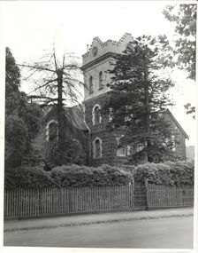
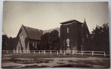
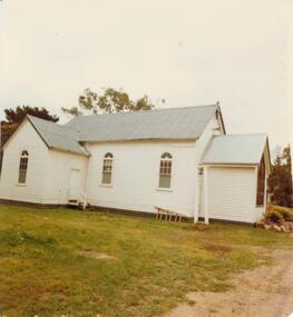
Postcard, Holy Trinity Church, 1905-1913
Holy Trinity Anglican Church is one of the parishes of the Diocese of Melbourne in the Anglican Church of Australia. Services of worship began in this building in March, 1863. The Vicarage was built in 1873, and both carry National Heritage classifications. The church contains many stained glass windows dating from the 19th century.Monochrome postcard showing the exterior of Holy Trinity Church, High Street, Kew. The western exterior of the church is viewed from High Street, Kew. The Church is surrounded by extensive vegetation, some later removed. The postcard predates 1913 when the tower was completed."Reg-No-KHS-411. Holy Trinity Church Kew - Prior to tower completion (1913)"holy trinity church -- kew (vic.), churches -- kew (vic.), postcards -- kew (vic.), postcards -- churches (vic.) -
 Kew Historical Society Inc
Booklet, Kew Baptist Church, Kew Baptist Church : The Achievements and Progress during 75 years, 1960s
This work forms part of the collection assembled by the historian Dorothy Rogers, that was donated to the Kew Historical Society by her son John Rogers in 2015. The manuscripts, photographs, maps, and documents were sourced by her from both family and local collections or produced as references for her print publications. Many were directly used by Rogers in writing ‘Lovely Old Homes of Kew’ (1961) and 'A History of Kew' (1973), or the numerous articles on local history that she produced for suburban newspapers. Most of the photographs in the collection include detailed annotations in her hand.The Rogers Collection provides a comprehensive insight into the working habits of a historian in the 1960s and 1970s. Together it forms the largest privately-donated collection within the archives of the Kew Historical Society.A booklet produced to celebrate the 75th anniversary of the Kew Baptist Church in Highbury Grove. The 24-page booklet includes a history of the church and its groups. Photographs of the buildings, office bearers and members are includedbaptist church (kew), churches -- kew (vic) -
 Kew Historical Society Inc
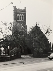
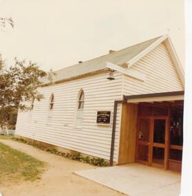
Photograph, Progress Press, Holy Trinity Church, High Street, c.1978
Holy Trinity Anglican Church is one of the parishes of the Diocese of Melbourne in the Anglican Church of Australia. Services of worship began in this building in March, 1863. The Vicarage was built in 1873, and both carry National Heritage classifications. The church contains many splendid stained glass windows dating from the 19th century.Holy Trinity Church, High Street, Kew. Inscription on reverse: "KH-224. Holy Trinity COFE Kew. Entered to the Heritage Register 1978. Photo presented by Progress Press."churches -- kew (vic.), holy trinity church -- high street -- kew (vic.) -
 Kew Historical Society Inc
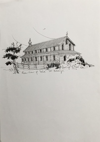
Drawing, Dione McIntyre, Rear view of 'old' St Hilary's, 2013
The first St. Hilary’s Church of England (Kew) was a timber building on the corner of John and Rowland Streets, designed in 1888 by Albert Purchas. This timber building was demolished in the 1940s to make way for a new church and tennis courts. The drawing was made to accompany a newsletter article by Dione McIntyre.Pen and ink drawing of the rear view of ‘old’ St Hilary’s, drawn by Dione McIntyre, 2013. "Rear view of 'old' St Hilary's"st hilary's church (kew), dione mcintyre, churches -- kew (vic) -
 Sunbury Family History and Heritage Society Inc.
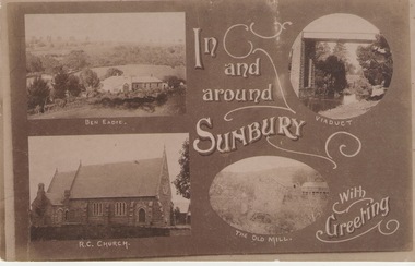
Post Card, Inb and around Sunbury
The post card is one of a set of commercial cards produced for Sunbury. Each card featured particular buildings or places of interest in the town. This card included Ben Eadie winery, Our Lady of Mt. Carmel Catholic Church, the former old mill by Jacksons Creek and the railway viaduct and bridge at Rupertswood. All the buildings featured on the card are of historical significance to Sunbury's early development.A post card featuring a collage four sepia views of Sunbury. The following greeting is written on the card: In and around Sunbury with Greeting. ben eadie winery, our lady of mount carmel catholic church, railway viaduct, the old mill -
 Sunbury Family History and Heritage Society Inc.
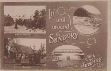
Post Card, In and around Sunbury with Greeting
The post card is one of a set that were produced by Chris Christainsen, who had a pharmacy in Sunbury and was also a photographer. The four photos featured on the card are the Rupertswood Mansion, St Mary's Church of England, Jacksons Creek in floods ands Sunbury Railway station.The buildings and places featured on the card are of historical significance in the Sunbury town precinct. A post card with four sepia photographs of interesting sites which can be seen in the Sunbury township. IN AND AROUND SUNBURY WITH GREETING. christainsen, chris., rupertswood mansion, st. mary's church of england., jacksons creek, sunbury railway station -
 Sunbury Family History and Heritage Society Inc.
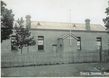
Photograph, C1880 - 1910
The building in the photograph was the first Sunbury State School No.1002. Prior to the school being built, lessons were conducted in the Presbyterian Church. After parents organised a petition in 1869 for the school to be housed in a proper building and a committee of management was formed, work on a new school building commenced. The old building had many structural deficiencies and the red brick building was built on the same site in 1911. A black and white photograph of an austere looking rendered building with a flagpole attached to a small portico at the entrance of the building. The roof is corrugated iron and has two air vents and two chimneys on it. There is a picket fence with a gate across the front and a tree is growing in the front.sunbury state school no. 1002., macedon street, stawell street -
 Sunbury Family History and Heritage Society Inc.
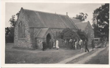
Photograph, c 1930s
St. Mary's Anglican Church at Bulla originally occupied a site along Oaklands Road, adjacent to 'Woodlands' homestead. It was established in 1859. With there building of the Melbourne Airport at Tullamarine it was found that the church on its existing site was directly under the flight path of the aircraft so the building was demolished stone by stone and rebuilt in the Bulla township adjacent to the Alistair Clark Rose Garden. The original site has not been developed because some early graves are there.St. Mary's Church at Bulla is one of the earliest to be established in the Bulla district. Its mother church, St Pauls Church of England at the original Broadmeadows township was established in 1850 and it still stands and operates on its original site.A black and white photograph with a cream border of a stone church with the congregation members entering the church. A saloon car is parked near the church.st. mary's church of england, bulla., churches. -
 Ringwood and District Historical Society
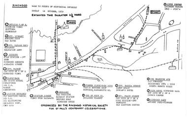
Pamphlet, Ringwood Walk - Points of Historical Interest, 1979
Sketch of walking route for 17 historical points of interest organised by the Ringwood Historical Society for St. Paul's Church Centenary Celebrations - 14 October 1979, estimated duration 2-1/4hours.1 - Start 2 - Cnr Braeside Avenue, old township, brickworks 1881-1916, Guests, Herrys, Hills 3 - Club Hotel, Ringwood Hall, 1st site of C of E church corner 4 - Ringwood Lake, Anthony Ford - pioneer 5 - Opposite Bardia Street, Sandy Gully, Duncan's Hotel 6 - Opposite Pratt Street, 2nd site of C of E, 2nd fire station, Bentleys, old shopping centre 7 - Warrandyte Road, Former Clocktower site, Pratts butcher shop, Bamfords 8 - End of Pitt Street, building viaduct 9 - Bedford Road, Webdales, old crossing, railway station 10 - Station Street, views over railways 11 - Station entrance, old shopping centre, 2nd Postoffice, 2nd blacksmiths, Mechanics Institute, Town Hall 12 - Clocktower, 3rd State School, coolstores, 3rd Postoffice, market, Kenworthys 13 - Opposite market, 3rd site of C of E, Ringwood views 14 - Adelaide Street, Dickens, 1st fire station, Ringwood Reserve 15 - Opposite squash courts, Matlocks, Salvation Army 16 - Opposite library, bowling club, old baths 17 - Outside C of E, Ringwood views, Brittens, Glamorgan -
 Flagstaff Hill Maritime Museum and Village
Functional object - Vase, circa 1944
This vase, one of a part of a pair of organ vases, was part of the original furnishings of the St Nicholas' Mission to Seamen's Church at 139 Nelson Place, Williamstown, Victoria. THE MISSIONS TO SEAMEN (Brief History: for more, see our Reg. No. 611, Set of Pews) The Missions to Seamen, an Anglican charity, has served seafarers of the world since 1856 in Great Britain. It symbol is a Flying Angel, inspired by a Bible verse. Today there are centr4es in over 200 ports world-wide where seamen of all backgrounds are offered a warm welcome and provided with a wide range of facilities. In Victoria the orgainsation began in Williamstown in 1857. It was as a Sailors’ Church, also known as ‘Bethel’ or the ‘Floating Church’. Its location was an old hulk floating in Hobson’s Bay, Port of Melbourne. It soon became part of the Missions to Seamen, Victoria. In the year 2000 the organisation, now named Mission to Seafarers, still operated locally in Melbourne, Portland, Geelong and Hastings. The Ladies’ Harbour Lights Guild was formed in 1906 to support the Missions to Seamen in Melbourne and other centres such as Williamstown. Two of the most significant ladies of the Guild were founder Ethel Augusta Godfrey and foundation member Alice Sibthorpe Tracy (who established a branch of the Guild in Warrnambool in 1920). The Guild continued its work until the 1960s. In 1943 a former Williamstown bank was purchased for the Missions to Seaman Club. The chapel was named St Nicholas’ Seamen’s Church and was supported by the Ladies’ Harbour Lights Guild, the Williamstown Lightkeepers’ Auxiliary and the League of Soldiers’ and Sailors’ Friends. It ceased operation in 1966. A Missions to Seamen Chapel and Recreation Room was a significant feature of ports during the late 1800s and into the 1900s. It seemed appropriate for Flagstaff Hill to include such a representation within the new Maritime Village, so the Melbourne Board of Management of Missions to Seamen Victoria gave its permission on 21st May 1979 for the entire furnishings of the Williamstown chapel to be transferred to Flagstaff Hill. The St Nicholas Seamen’s Church was officially opened on October 11, 1981 and closely resembles the Williamstown chapel. This vase, and its pair, is significant through its association with the St Nicholas' Mission to Seamen Church in Williamstown, Melbourne, established in 1857. The items in our collection from the Missions to Seamen in Williamstown, Victoria, have historical and social significance. They show that people of the 1800s and 1900s cared about the seafarers’ religious, moral, and social welfare, no matter what the religion, social status or nationality. It had its origins in Bristol, England when a Seamen's Mission was formed in 1837. The first Australian branch was started in 1856 by the Rev. Kerr Johnston, a Church of England clergyman, and operated from a hulk moored in Hobson’s Bay; later the Mission occupied buildings in Williamstown and Port Melbourne. Vase, one of a pair, of organ vases, polished brass church vases with truncated conical shapes. White sticker under vase with hand written number "136" This is one of the original items in our ‘St Nicholas Seamen's Church Williamstown Collection’.White sticker under vase with hand written number "136" flagstaff hill, warrnambool, shipwrecked-coast, flagstaff-hill, flagstaff-hill-maritime-museum, maritime-museum, shipwreck-coast, flagstaff-hill-maritime-village, vase, church vase, brass vase, conical vase, religion, religious service, sailors rest, bethel sailors’ church, bethel floating church, ladies harbour light guild, missions to seamen victoria, mission to seafarers, st nicholas seaman’s church williamstown, st nicholas mission to seamen church williamstown, mission to seamen williamstown, st nicholas seamen’s church flagstaff hill, 139 nelson place williamstown, flying angel club, organ vase -
 Greensborough Historical Society
Document - Leaflet, Introducing the Monty Hub Project, 2021 c
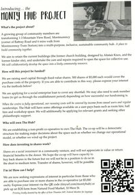
... Proposal to develop the site with existing buildings at 1-3... as a community hub. The buildings are a former church and kindergarten ...Proposal to develop the site with existing buildings at 1-3 Mountain View Road Montmorency as a community hub. The buildings are a former church and kindergarten designed by Alistair Knox. 2 p., printed in black both sides on off white paper, plan, photographmontmorency hub, monty hub project -
 Phillip Island and District Historical Society Inc.
Photograph, 1959
Donated by Jack JennerBlack & White photograph of Chapel Street Cowes with Catholic church and houses in background. Corner Co-Op site in foreground immediately before building. Glencoe Guest House next to Co-Op.On Back: "Co-op Corner & C. Church. 1960"phillp island co-op cowes, glencoe guest house, chapel street, cowes phillip island, phillip island, jack jenner -
 Phillip Island and District Historical Society Inc.
Photograph, 1978/79
The house was built with bricks made by Robert Anderson, a Scottish engineer who had a Hoffman Brick Kiln on the corner of McHaffie Drive and Church Street, Cowes.Brick house in Walpole Street, Cowes made of local Anderson bricks.local history, photographs, buildings, historic, buildings - historical, coloured photograph, john cook, phillip island -
 Phillip Island and District Historical Society Inc.
Photograph, 1978/79
The site on the corner of Thompson Avenue and Church Street, Cowes was reserved on the 12th April 1869 and the church was erected by the end of the year. Financed by the Island Church of England people. Dean McCartney preached the first sermon and performed the dedication service on 30th January 1870. Prior to this time services were held at the McHaffie homestead, Ventnor. Mrs S D (Georgianna) McHaffie, wife of the first European settlers, wrote in her diary "30th January 1870. Drove to Cowes, opened the Church, fine day". the large Bible presented by her is on loan and displayed in the Museum of the Phillip Island & District Historical Society.The timber Anglican Church of St Philips was built by Alex McLardy Sen. in 1869. It is still situated in Thompson Avenue on the corner of Church Street. The Vestry was added by Mr Alex McLardy in 1903 at the cost of 21 pounds. In 1912 a Sanctuary was added to the church and a Memorial Stained Glass Window donated by Miss Rose in memory of her father and two brothers was installed.local history, photographs, buildings, historic, buildings - historical, coloured photograph, john cook, phillip island, anglican church -
 Phillip Island and District Historical Society Inc.
Photograph, 1978/79
The land in Chapel Street was granted by the Presbyterian Church in 1869. A church was finally built by Alex McLardy at a cost of £127 and was dedicated in august 1895. The first Presbyterian Church services held on Phillip Island in 1889 were conducted under a tree in the open air. May 1890 Dr. Alexander Robb was appointed the first Minister and continued until his death 11 years later. 1929 an annex was built providing more accommodation. 1968 the joint Presbyterian and Methodist congregation was formed. In 1975 a new building was dedicated.St John's Uniting Church, Chapel Street, Cowes. Large wooden structure combining Church and Hall. In 1971 the building committee commissioned an architect who designed the building with an unusual roof structure which reflected the concept of a keel of a ship - appropriate for the setting of a building by the sea. The bell is from the wrecked ship "The Speke".local history, photographs, buildings, historic, buildings - historical, coloured photograph, john cook, phillip island, st john's church cowes, uniting church cowes phillip island