Showing 8418 items
matching no. 37
-
 Bendigo Historical Society Inc.
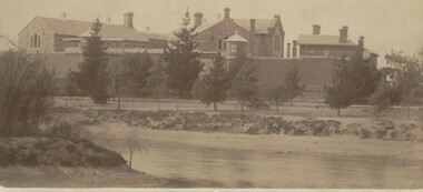
Photograph - BENDIGO GAOL, FROM COMMISSIONER'S GULLY, c.1880
Sepia photograph of the Bendigo Gaol looking across from Barnard Street, Mining dam in foreground. . Conifers along Northern bank of creek with gaol buildings in the background. All buildings are of masonry. Inscriptions: '37' in red ballpoint ink top RH corner. On back of mount: stamped in circle 'Royal Historical Society of Victoria, Bendigo Branch' In blue ballpoint ink above circly '1959' In red ballpoint ink above circle '37'. In blue ballpoint ink in one corner '1880'. Inclusions in storage envelope: Bendigo Gaol, J Lerk, 28/02/2000. The Bendigo Gaol looking across Commissioner's Gully c1880. The grey granite cell blocks contrast with the red brick exterior walls. Photograph courtesy Bendigo Historical Sociery (No. 136, texta on back). Machine printed inclusion worded as above entry. Another inclusion written in pencil states ' Bendigo Gaol about 1880. Granite from Big Hill was used to construct the cell blocks about 1860. Prisioners did not have heating, beds, seats or eating utensils. A public meeting in 1862 called for the debtor's quarters at the gaol to be lit with gas, handsomely furnished throughout and that inmates be provided with a bottle of wine, one bottle of brandy daily and tobacco and pipes availabe at liberty. (from Butcher, 'Annals of Bendigo 1862, Vol. 1, 76B).buildings, government, watch house, sandhurst -
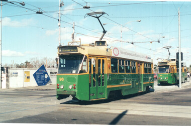
 Ballarat Tramway Museum
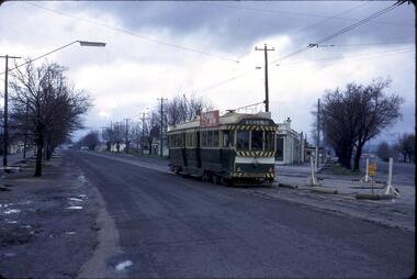
Photograph - Digital image set of 6, 27/06/1971 12:00:00 AM
Yields information about the SEC Ballarat trams in the months before the closure of the SEC Tramway system. Yields information about the streetscape.Set of six Digital images, scanned from slides by Graeme Cleak, scanning by Peter Winspur 9/2011. .1 - Slide FQ16 - No. 41, outbound at the south end of Drummond St south about to turn into Skipton St, with the destination of Bell St. .2 - slide FQ18 - No. 41, outbound to Sebastopol terminus, Albert St, just before the terminus itself. .3 - slide FQ21 - No. 41, inbound Albert St Sebastopol with the Sebastopol Town Hall in the background. Tram has a "Bliss Bombs" roof advertisement on the side, "Make Bliss, Not Love". .4 - slide FQ22 - Trams 26 and 41, crossing at Grey St Sebastopol Loop. No. 41 has destination of Grey St. .5 - slide FQ27 - Trams 27 and 37, crossing at the Hamilton Ave loop, No. 41 inbound - with destination of Victoria St at the Hamilton Ave loop with the "Stonehenge" fence house in the background. Sturt St West. .6 - slide FS29 - No. 37 at Grenville St, Sturt St intersection with Bridge St in the background. Tram has the destination of View Point and is entering the loop itself. The destination was no longer in use at the time of the photograph and would indicate that the destination has been arranged. In the background is the Woolworths Big W store and the Dickins Food Store. All photos taken on 27/6/1971. trams, tramways, drummond st sth, sebastopol, grey st, albert st, sturt st west, grenville st, tram 41, tram 26, tram 27, tram 37 -
 Eltham District Historical Society Inc
Photograph - Aerial Photograph, Landata, Research, Vic, Apr. 1963
Centred on present day Marconi Court, Research bounded by Maroondah Aqueduct to north, Thompson Crescent to south, Joselyn Drive to east and Eltham Research Oval to west. Historic Aerial Imagery Source: Landata.vic.gov.au Aerial Photo Details: Project No :486 Project : MELBOURNE (1963) PROJECT Run : 5 Frame : 62 Date : 04/1963 Film Type : B/W Camera : RC8 Flying Height : 5100 Scale : 9600 Film Number : 1805 GDA2020 : 37°42'24"S, 145°10'43"E MGA2020 : 339434, 5825157 (55) Melways : 22 F3 (ed. 42)aerial photo, neil webster collection, 1963-04, joselyn drive, marconi court, melway 22f3, research (vic.), research oval, thompson crescent -
 Eltham District Historical Society Inc
Photograph - Aerial Photograph, Landata, Research, Vic, Apr. 1972
Centred on present day Maroong Drive, Research bounded by Allendale Road to north, Thompson Crescent to south, Eltham College to east and Parsons Road to west. Historic Aerial Imagery Source: Landata.vic.gov.au Aerial Photo Details: Project No :985 Project : MELBOURNE 1972 Run : 26 Frame : 193 Date : 04/1972 Film Type : B/W Camera : RC10 Flying Height : 5700 Scale : 9600 Film Number : 2636 GDA2020 : 37°42'04"S, 145°10'33"E MGA2020 : 339187, 5825794 (55) Melways : 22 F1 (ed. 42)aerial photo, neil webster collection, 1972-04, allendale road, eltham, eltham barrel, eltham college, maroong drive, melway 22f1, parsons road, research (vic.), thompson crescent -
 Eltham District Historical Society Inc
Photograph - Aerial Photograph, Landata, Eltham, Vic, Apr. 1972
Centred on present day Ryans Road at Sandra Avenue, Eltham bounded by Progress Road to north, Brougham Street to south, Bible Street to east and Outlook Crescent to west. Historic Aerial Imagery Source: Landata.vic.gov.au Aerial Photo Details: Project No :985 Project : MELBOURNE 1972 Run : 27 Frame : 48 Date : 04/1972 Film Type : B/W Camera : RC10 Flying Height : 5700 Scale : 9600 Film Number : 2636 GDA2020 : 37°42'41"S, 145°08'38"E MGA2020 : 336392, 5824574 (55) Melways : 21 H4 (ed. 42)aerial photo, neil webster collection, 1972-04, eltham, bible street, brougham steet, melway 21h4, outlook crescent, progress road, ryans road, sandra avenue, montmorency -
 Eltham District Historical Society Inc
Photograph - Aerial Photograph, Landata, Montmorency, Vic, Apr. 1972
Centred on present day Olympic Avenue at Grand Boulevard, Montmorency bounded by Meruka Drive to north, Main Road to south, Main Road to east and Alban Street to west. Historic Aerial Imagery Source: Landata.vic.gov.au Aerial Photo Details: Project No :985 Project : MELBOURNE 1972 Run : 28 Frame : 206 Date : 04/1972 Film Type : B/W Camera : RC10 Flying Height : 5700 Scale : 9600 Film Number : 2635 GDA2020 : 37°43'21"S, 145°07'46"E MGA2020 : 335154, 5823329 (55) Melways : 21 E7 (ed. 42)aerial photo, neil webster collection, 1972-04, eltham, alban street, grand boulevard, lower plenty, main road, melway 21e7, meruka drive, montmorency, olympic avenue -
 Eltham District Historical Society Inc
Photograph - Aerial Photograph, Landata, Eltham, Vic, Apr. 1972
Centred on present day Mays Road at Stringybark Road, Eltham bounded by Nyora Road to north, Yarra River to south, Reynolds Road to east and Bible Street to west. Historic Aerial Imagery Source: Landata.vic.gov.au Aerial Photo Details: Project No :985 Project : MELBOURNE 1972 Run : 28 Frame : 209 Date : 04/1972 Film Type : B/W Camera : RC10 Flying Height : 5700 Scale : 9600 Film Number : 2635 GDA2020 : 37°43'33"S, 145°09'28"E MGA2020 : 337647, 5823013 (55) Melways : 22 B8 (ed. 42)aerial photo, neil webster collection, 1972-04, eltham, bible street, mays road, melway 22b8, nyora road, reynolds road, stringybark road, yarra river -
 Eltham District Historical Society Inc
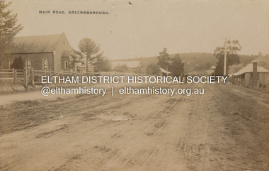
Postcard - Photograph postcard, Main Road, Greensborough, c.1910
View looking northeast along Main Street. The Greensborough Methodist Church stood at the present-day entrance to Greensborough Plaza shopping centre at 25 Main Street, Greensborough. It was opened in 1873. The Main Street Church served the congregation well, but by the 1960s it was decided to sell the old building and invest in a new home. The land at 37 Grimshaw Street for the current Uniting church was purchased in 1962 from the estate of Mrs White. Construction commenced on 31 July 1965 and the new church was opened on February 5, 1966. (https://www.churchhistories.net.au/church-catalog/greensborough-vic-uniting)Digital file only Postcards scanned from the collection of Michael Aitken on loan to EDHS, 2 Sep. 2022michael aitken collection, postcards, greensborough, main street, methodist church -
 Eltham District Historical Society Inc
Photograph - Aerial Photograph, Landata, Eltham, Main Road; Henry St to Bellevue Rd, Dec. 1945
Eltham, Main Road; Henry St to Bellevue Rd, and east along Luck St to present day Eltham East School Historic Aerial Imagery Source: Landata.vic.gov.au Aerial Photo Details: Project No :5 Project : MELBOURNE AND METROPOLITAN AREA PROJECT Run : 36 Frame : 60549 Date : 12/1945 Film Type : B/W Camera : EAG4 Flying Height : 10200 Scale : 6000 Film Number : 228 GDA2020 : 37°42'45"S, 145°08'59"E MGA2020 : 336903, 5824465 (55) Melways : 21 K4 (ed. 42)aerial photo, arthur street, bellevue road, bible street, diamond street, dudley street, elsa court, eltham, eltham east primary school, gahan house, henry street, livingstone road, luck street, main road, pryor street, neil webster collection -
 Warrnambool and District Historical Society Inc.
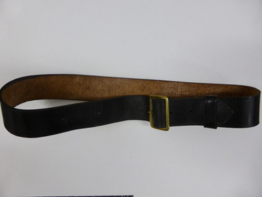
Clothing, Warrnambool Urban Fire Brigade Belt, Mid 20th century
This belt was worn with the jacket issued to members of the Warrnambool Fire Brigade in the mid 20th century. The jacket was part of the uniform that served both as a dress uniform and a work uniform. The Warrnambool Fire Brigade was formed in 1863 following unsuccessful attempts to establish a permanent fire service in the town. It was prompted by a fire at the Flying Buck Hotel in Liebig Street. The Warrnambool Fire Brigade, now located on the Mortlake Road, has been successful in Victorian Fire Brigade competitions and demonstrations, particularly in the 19th century. The owner of the belt and uniform was John (Jack) Sizeland, a member of the Warrnambool Fire Brigade for over 37 years. This belt is of interest as it was part of a Warrnambool Fire Brigade uniform during the second half of the 20th century. It also has individual local provenance as it belonged to Jack Sizeland, a member of the Warrnambool Fire Brigade who retired in 1977 after 37 years of service. This is a brown leather belt with a gold metal buckle and nine punched holes on the buckle, two of them hand-punched. It has a leather attachment to keep the belt end in place. It has the name of the owner, John Sizeland, written in biro on the inside of the belt. This belt is meant to be worn with the Warrnambool Fire Brigade jacket with the brass buttons. ‘J. Sizeland, W’bool’warrnambool fire brigade, jack sizeland, history of warrnambool -
 Melbourne Tram Museum
Photograph - Set of 6 colour prints of trams at Corner of Flinders and Swanston Streets, George Bishop, c1999
Set of six colour photographs of trams at the corner of Swanston and Flinders Streets. In the background can be seen the construction of the Federation Square project which commenced in 1999. 1 - Z 96 (Route 3, University) at Flinders and Swanston Streets. 2 - Z 37 (University route 5) 3 - SW6 888, City Circle, westbound. 4 - Z3 140 (East Coburg Route 1) - would appear that the car is not doing their hook turn properly 5 - B2 2037 westbound (Route 70, City Flinders St) 6 - Z 41 (Route 72, University)Yields information about the operation of Melbourne trams during the late 1990s.Set of six Colour prints printed on Kodak paperDetails of the photograph and photographer on the rear in ink.trams, tramways, z3 class, z class, tram 96, tram 37, city circle, tram 888, hook turns, tram 140, b2 class, tram 2037 -
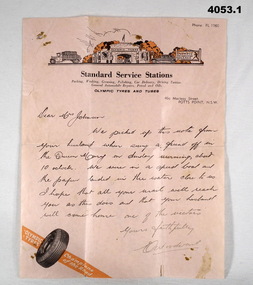 Bendigo Military Museum
Letter - LETTERS WW2, 2) 20.10.1940
Harold James Thomas Johnson TX3956 enlisted on 25.7.1940, aged 37. Served with the 7th Division Ammunition Supply Coy A.A.S.C as a driver. He was discharged om 30.11.1945 with the rank of L/Cpl. .1) Letter is to 'Dear Mrs Johnson". The contents of the note relate to the writer picking up the note which was thrown over the side of the Queen Mary and they picked it up form the water and later posted it on. .2) Note torn in half from "TX3956 B Section 7 DIV AMN COY 2nd AIF ABROAD" To "Mrs H. JOHNSON HOLLAND HOUSE WILMOT ST BURNIE TASMANIA, Husband on Queen Mary Everything okay, Love Harold". This is believed to be the note thrown overboard in .1). .3) The letter from H, Johnson is to "Brooks McGlashan & ?? PTY LTD", thanking them for parcels received VIA the Aust. Comforts Fund. Point .1) on the rear has three handwritten names in pencil: "TX3930, Thomas Charles Munn, 7th AFG Brighton" "TX3422, Pte. K.V. Smith 6th Rfts I.T.D Brighton" "30337 AC1 Sayer Group 37 - Ascot Vale" All three enlisted in 1940. Munn was discharged 23.6.1946 in 8 Div AASC Smith was discharged 12.11.1945 in 2/8 Fld Regt. Sayer was discharged 9.11.1945 in 7 AIRCRAFT Depot (RAAF) Refer to Cat. No. 4052.7P for photos. .1) Letter, pink paper, letterhead, "STANDARD SERVICE STATIONS" with drawing above, tyre at bottom, letter written in ink. .2) Letter, yellowed, ruled lines, map of Australia with Red Shield centre "The Salvation Army". Note written in pencil. Note has been torn from rest of page. .3) Letter, yellowed paper, hand written in ink from H. Johnson.letters, 7th, aasc -
 Emerald Museum & Nobelius Heritage Park
Administrative record - Nobelius Nursery Cash book, October 1903- December 1910, 16/10/1903 - 18/12/1910
The Cash Accounts contain the names and transaction details of all Gembrook Nursery clients. As well as private individuals, clients also included the following: Fitzroy City Council (p.2, 23, 41, 58. 93); Collingwood Council (p.2, 11, 54, 62, 71, 93); Lands Dept (p.2,5, 28, 30, 45, 61, 73); Melbourne Water Supply (p. 2); Victorian Railways (p.4, 6, 7,17,19, 20, 21, 22, 23, 24, 25, 27, 29, 31, 32, 33, 35, 37, 47......); Salvation Army (p.5, 36, 72, 94); Hawthorn Council (p.11, 37, 57, 69); Kew Council (p.12, 34, 55); Caulfied Shire Council (p.14, 35, 37,53, 69, 90, 93, 108); City of Melbourne (p. 26, 54, 96); Narre Warren Library (p. 44)., Public Works Dept (p. 55); Nunawading Shire Council (p. 70); Prahran Shire Council (p. 91, 102, 108); Dept of Agriculture N.Z.(p. 93); Hawkesbury Ag College (p. 93); Cremorne Nursery (p. ......., 94); Stawell Shire Council (p. 95); Monbulk Jam Factory (p. 100, Euroa shire Council (p. 108))The accounts also track Nobelius' travel expenses.The cash account books are historically, and socially significant as the entries give an insight into the growth of the company and the details payments from local and other government offices and overseas customers as well as significant companies associations and people. The earlier account books also detail wage payments.Hard cover cash book, brown leather binding, black cover, pink marbled end paper, book has 239 pages all used, date starts 16th October 1903 and ends 18th December 1910. c. a. nobelius & sons, gembrook nurseries, horticulture, accounting, emerald -
 Emerald Museum & Nobelius Heritage Park
Administrative record - Nobelius Nursery Cash Book, 1895-1908, 21 August 1895 - 12 October 1903
The Cash Accounts contain the names and transaction details of all Gembrook Nursery clients. As well as private individuals, clients also included the following: Fitzroy City Council (p.2, 23, 41, 58. 93); Collingwood Council (p.2, 11, 54, 62, 71, 93); Lands Dept (p.2,5, 28, 30, 45, 61, 73); Melbourne Water Supply (p. 2); Victorian Railways (p.4, 6, 7,17,19, 20, 21, 22, 23, 24, 25, 27, 29, 31, 32, 33, 35, 37, 47......); Salvation Army (p.5, 36, 72, 94); Boroondara Council (p.11, 37, 57, 69); Kew Council (p.12, 34, 55); Caulfied Shire Council (p.14, 35, 37,53, 69, 90, 93, 108); City of Melbourne (p. 26, 54, 96); Narre Warren Library (p. 44)., Public Works Dept (p. 55); Nunawading Shire Council (p. 70); Prahran Shire Council (p. 91, 102, 108); Dept of Agriculture N.Z.(p. 93); Hawkesbury Ag College (p. 93); Cremorne Nursery (p. ......., 94); Stawell Shire Council (p. 95); Monbulk Jam Factory (p. 100, Euroa shire Council (p. 108))The accounts also track Nobelius' travel expenses.The cash account books are historically, and socially significant as the entries give an insight into the growth of the company and the details payments from local and other government offices and overseas customers as well as significant companies associations and people. The earlier account books also detail wage payments.Hard cover cash book, with maroon embossed cover (alligator print cover), inner cover marbled front and back, cash book has a total of 139 pages all used, date starts 1895 and concludes in 1908c. a. nobelius & sons, gembrook nurseries, horticulture, accounting, emerald -
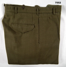 Bendigo Military Museum
Uniform - TROUSERS, ARMY, Australian Defence Industries, 1969
Trousers - Khaki, wool serge fabric, plastic buttons, five buttons, fly, fob pocket, two side pockets, one back pocket with flap. Lining - cotton and polyester fabric. Cotton manufacturers label, inside on back pocket lining, with black print information.Cotton label information - black ink print. "CONWAY BROS. PTY LTD/ ADELAIDE 1969/^/ CLASS 8405-66-025-6188/ SIZE WAIST 325/ MATCHING JACKET 37-395/ DRY CLEAN ONLY/ RE-PRESS ON ORIGINAL SEAMS/ Creases set by Si-va-set/ mending Patch attached/ NAME/ ARMY NO". NAME - HANDWRITTEN ON LABEL - BLACK INK - ILLEGIBLE.uniform, army, battle dress trousers -
 City of Greater Bendigo - Civic Collection
Leisure object - Netball ball, Australian Diamonds Netball Team, 2014
The Australian Women's netball team the Diamonds, played England in Bendigo on Sunday October 19, 2014. 'Fresh from a four-Test Constellation Cup clean sweep against New Zealand last week, the Diamonds started the game at a blistering pace, with wing attack Madi Robinson running rings around her rivals. England tried to go with them but the trade-off was a high error count and while they settled in the second quarter they still trailed 29-17 at halftime'. www.theguardian.com/sport/2014/oct/19/australian-diamonds-crush-england-in-first-netball-testSigned 'Gilbert' netball in acrylic display case. Wooden base with plaque on front.Australian Diamonds Team / International Test Series Netball / Australian Diamonds V England / 19 October 2014, Bendigo Stadium / Score Australia 55 - England 37 (Signed) Caitlin Bassett, Laura Geitz, Kim Ravaillion, Madi Robinson, Caitlin Thwaites, Susan Pettitt, April Brandley, Courtney Bruce, Jo Weston, Gabi Simpson, Liz Watson, Stephanie Wood.city of greater bendigo sport, bendigo stadium -
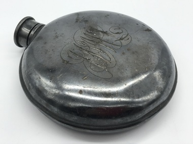 Melbourne Legacy
Functional object - Ephemera, Flask and ID Badge
A group of items including an identification tag on a leather wrist strap, flask and boot hook. Also a circular ID tag possibly made to be worn around the neck. Also a Ypres souvenir that seems incomplete. These were with other World War 1 memorabilia that has come from Private John Basil McLean, 2nd Reinforcements, 37th Battalion, A.I.F. Possibly these were with him during his time in the First World War and he kept them as a mementos. J.B. McLean (Service No. 13824) was from near Maffra, Victoria and enlisted on 22 January 1916. He embarked on 16 December 1916 for Europe. He spent time with the Australian Field Artillery (Pack Section). At the end of the war he worked for a year at the A.I.F. Headquarters in London before returning to Australia on the 'Ceramic', arriving in Portsea in 1920. His full war record is available from the National Archives of Australia (B2455, MCLEAN JBM).Mementos brought back with a soldier after serving in Europe in World War One.A metal flask, an identification tag, a boot hook, a circular identification tag, a souvenir from Ypres all from the collection of JB McLean.01126.1 Flask has monogram 'JBMCL' engraved on it. 01126.2 Identification tag has 'No. 13824 JB M McLean, ASC, AIF, RC' engraved on it. 01126.3 The boot hook has 'BAILLEUL' engraved on it. 00126.4 The circular tag with a central star has 'PTE J B M McLean A Coy 37 Bat' pressed into the metal. 00126.5 A metal tube with the letters 'Ypres' adhered to the outside. world war one, souvenir -
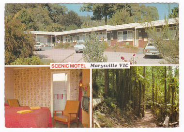
 Marysville & District Historical Society
Postcard (item) - Colour postcard, R. Bell, SCENIC MOTEL Marysville VIC, Unknown
A colour postcard of the Scenic Motel in Marysville. The postcard was produced by Bellevue Color Views Australia as a souvenir of Marysville.A colour postcard of the Scenic Motel in Marysville. The postcard was produced by Bellevue Color Views Australia as a souvenir of Marysville.Produced/ and/ Printed/ in/ Australia Bellevue Color Views Australia Colour photography by R. Bell/ Box 37, Ormond Vic. SCENIC MOTEL/ 5 DARWIN STREET,/ MARYSVILLE, VICTORIA, 3779/ Phone: (059) 633 247 "The little Motel with the big view" Quite location, all facilities, Barbeque,/ parking at door, moderate tariff, personal/ attention from your hosts. BV 366marysville, victoria, australia, scenic motel, accommodation, postcard, souvenir, bellevue color views australia, r. bell -
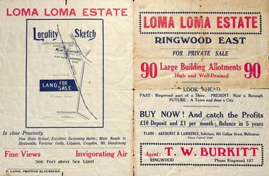 Ringwood and District Historical Society
Flyer, Land Sale Brochure, Loma Loma Estate, Ringwood East, Vic. - circa 1924
Flyer includes extract from "The Sun" 30/10/1924. "Ringwood has been created a Borough with capital value of £680,000. In 1908 there were 173 houses, 8 shops and 720 people. In 1918 the respective figures were 520, 45 and 2,080. For twelve months ended June, 1924, £51,000 worth of Home Sites were sold and £26,000 worth of new buildings were erected. Outward (train) passenger journeys have increased from 94,000 in 1919 to 182,000 in 1923. Train services have been almost doubled and time to Melbourne reduced from 60 to 37 minutes."Bi-fold double-sided land sale advertisement for Loma Loma Estate, Ringwood East, including area map, layout of the estate, and summary of local facilities and services.Subdivision includes Loma Street, Highton Street, Morinda Street, and Station Street (later Railway Avenue) Ringwood East. Agent: T.W. Burkitt, Ringwood, Phone Ringwood 157. -
 Eltham District Historical Society Inc
Photograph - Aerial Photograph, Landata, Eltham / Research, Vic, Jan. 1951
Centred on Brinkkotter Road opposite Yarramie Reserve, Eltham bounded by Maroondah Aqueduct to north, Nyora Road to south, Eltham College to east and Leane Drive to west. Historic Aerial Imagery Source: Landata.vic.gov.au Aerial Photo Details: Project No :65 Project : MELBOURNE AND METROPOLITAN PROJECT NO. 2 Run : 7 Frame : 8 Date : 01/1951 Film Type : B/W Camera : EAG9 Flying Height : 12200 Scale : 12000 Film Number : 1419 GDA2020 : 37°42'32"S, 145°10'41"E MGA2020 : 339408, 5824924 (55) Melways : 22 F3 (ed. 42)Historical aerial photos and photo maps provide viusal evidence of the chronology of changes to the built landscape of the district and assist in dating other imagesaerial photo, 1951-01, eltham, neil webster collection, brinkkotter road, eltham college, leane drive, maroondah aqueduct, melways 22f3, nyora road, yarramie reserve -
 Eltham District Historical Society Inc
Photograph - Aerial Photograph, Landata, Eltham, Vic, Jan. 1951
Centred on Beard Street between Main Road and Frank Street, Eltham bounded by Maroondah Aqueduct to north, Arthur Street to south, Maroong Drive to east and Catholic Ladies College to west. Historic Aerial Imagery Source: Landata.vic.gov.au Aerial Photo Details: Project No :65 Project : MELBOURNE AND METROPOLITAN PROJECT NO. 2 Run : 7 Frame : 9 Date : 01/1951 Film Type : B/W Camera : EAG9 Flying Height : 12200 Scale : 12000 Film Number : 1419 GDA2020 : 37°42'23"S, 145°09'39"E MGA2020 : 337874, 5825170 (55) Melways : 22 B3 (ed. 42)Historical aerial photos and photo maps provide viusal evidence of the chronology of changes to the built landscape of the district and assist in dating other imagesaerial photo, 1951-01, eltham, neil webster collection, arthur street, beard street, catholic ladies college, frank street, main road, maroondah aqueduct, maroong drive, melway 22b3, research (vic.) -
 Eltham District Historical Society Inc
Photograph - Aerial Photograph, Landata, Eltham North, Feb. 1956
Centred on present day 54 Kelway Crescent, Eltham North bounded by Glen Gully Road to north, Meruka Drive to south, Eltham College to east and Leach Street to west. Historic Aerial Imagery Source: Landata.vic.gov.au Aerial Photo Details: Project No :250 Project : MELBOURNE OUTER SUBURBS PROJECT Run : 17 Frame : 113 Date : 02/1956 Film Type : B/W Camera : EAG9 Flying Height : 10000 Scale : 12000 Film Number : 1176 GDA2020 : 37°42'16"S, 145°08'08"E MGA2020 : 335650, 5825336 (55) Melways : 21 G2 (ed. 42)aerial photo, 1956-02, eltham, eltham north, glen gully road, leach street, main road, melway 21g2, meruka drive, montmorency, neil webster collection -
 Eltham District Historical Society Inc
Photograph - Aerial Photograph, Landata, Montmorency, Feb. 1956
Centred on present day Tahlee Place Reserve and Sherbourne Preschool, Montmorency bounded by Progress Road to north, Withers Way to south, Main Road to east and Leach Street to west. Historic Aerial Imagery Source: Landata.vic.gov.au Aerial Photo Details: Project No :250 Project : MELBOURNE OUTER SUBURBS PROJECT Run : 17 Frame : 114 Date : 02/1956 Film Type : B/W Camera : EAG9 Flying Height : 10000 Scale : 12000 Film Number : 1176 GDA2020 : 37°42'50"S, 145°08'02"E MGA2020 : 335512, 5824286 (55) Melways : 21 F5 (ed. 42)aerial photo, 1956-02, neil webster collection, central park, eltham, leach street, main road, melway 21f5, montmorency, progress road, withers way, sherbourne preschool, tahlee place reserve -
 Eltham District Historical Society Inc
Photograph - Aerial Photograph, Landata, Lower Plenty, Feb. 1956
Centred on present day 217 Old Eltham Road, Lower Plenty bounded by Pitt Street to north, Yarra River to south, Main Road to east and Bonds Road to west. Historic Aerial Imagery Source: Landata.vic.gov.au Aerial Photo Details: Project No :250 Project : MELBOURNE OUTER SUBURBS PROJECT Run : 17 Frame : 116 Date : 02/1956 Film Type : B/W Camera : EAG9 Flying Height : 10000 Scale : 12000 Film Number : 1176 GDA2020 : 37°43'58"S, 145°07'49"E MGA2020 : 335237, 5822186 (55) Melways : 21 E10 (ed. 42)aerial photo, 1956-02, neil webster collection, eltham, main road, bonds road, elham, lower plenty, melway 21e10, pitt street, yarra river -
 Eltham District Historical Society Inc
Photograph - Aerial Photograph, Landata, Eltham, Feb. 1956
Centred on present day Shalbury Avenue, Eltham bounded by Leane Drive and Parsons Road to north, Nyora Road to south, Reynolds Road to east and the Diamond Creek to west Historic Aerial Imagery Source: Landata.vic.gov.au Aerial Photo Details: Project No :250 Project : MELBOURNE OUTER SUBURBS PROJECT Run : 18 Frame : 95 Date : 02/1956 Film Type : B/W Camera : EAG9 Flying Height : 10000 Scale : 12000 Film Number : 1176 GDA2020 : 37°41'57"S, 145°09'51"E MGA2020 : 338145, 5825965 (55) Melways : 22 C1 (ed. 42)aerial photo, 1956-02, neil webster collection, eltham, diamond creek (creek), melway 22c1, nyora road, parsons road, reynolds road, shalbury avenue -
 Eltham District Historical Society Inc
Photograph - Aerial Photograph, Landata, Research, Vic, Feb. 1956
Centred on present day Thompson Crescent, Research bounded by Maroondah Aqueduct to north, Thompson Crescent and Nyora Road to south, Bells Hill Road to east and Eucalyptus Road to west Historic Aerial Imagery Source: Landata.vic.gov.au Aerial Photo Details: Project No :250 Project : MELBOURNE OUTER SUBURBS PROJECT Run : 19 Frame : 6 Date : 02/1956 Film Type : B/W Camera : EAG9 Flying Height : 10000 Scale : 12000 Film Number : 1176 GDA2020 : 37°42'38"S, 145°11'02"E MGA2020 : 339927, 5824736 (55) Melways : 22 H4 (ed. 42)aerial photo, 1956-02, neil webster collection, bells hill road, eltham, eucalyptus road, maroondah aqueduct, melway 22h4, nyora road, research (vic.), thompson crescent -
 Eltham District Historical Society Inc
Photograph - Aerial Photograph, Landata, Research, Vic, Apr. 1963
Centred on present day Thompson Crescent and Nicholson Close, Research bounded by Maroondah Aqueduct to north, Nyora Road to south, Eltham College to east and Eltham Gateway Hotel to west. Historic Aerial Imagery Source: Landata.vic.gov.au Aerial Photo Details: Project No :486 Project : MELBOURNE (1963) PROJECT Run : 5 Frame : 61 Date : 04/1963 Film Type : B/W Camera : RC8 Flying Height : 5100 Scale : 9600 Film Number : 1805 GDA2020 : 37°42'24"S, 145°10'06"E MGA2020 : 338528, 5825143 (55) Melways : 22 D3 (ed. 42)aerial photo, neil webster collection, eltham, 1963-04, eltham college, eltham gateway hotel and conference centre, maroondah aqueduct, melway 22d3, nicholson close, nyora road, research (vic.), thompson crescent -
 Eltham District Historical Society Inc
Photograph - Aerial Photograph, Landata, Eltham, Vic, Apr. 1963
Centred on present day John Street, Eltham between Main and Bible streets bounded by Elsa Court to north, Main Road Bridge to south, Wattle Grove to east and Bolton Street to west. Historic Aerial Imagery Source: Landata.vic.gov.au Aerial Photo Details: Project No :486 Project : MELBOURNE (1963) PROJECT Run : 6 Frame : 123 Date : 04/1963 Film Type : B/W Camera : RC8 Flying Height : 5100 Scale : 9600 Film Number : 1805 GDA2020 : 37°43'12"S, 145°08'54"E MGA2020 : 336800, 5823623 (55) Melways : 21 J6 (ed. 42)aerial photo, neil webster collection, 1963-04, bolton steet, elsa court, eltham, john street, main road, main road bridge, melway 21j6, wattle grove -
 Eltham District Historical Society Inc
Photograph - Aerial Photograph, Landata, Eltham, Vic, Apr. 1963
Centred on present day Eltham Ridge, Bolton Street, Eltham bounded by Elsa Court to north, Main Road to south, Bible Street to east and Reichelt Avenue and Rattray Road to west. Historic Aerial Imagery Source: Landata.vic.gov.au Aerial Photo Details: Project No :486 Project : MELBOURNE (1963) PROJECT Run : 6 Frame : 124 Date : 04/1963 Film Type : B/W Camera : RC8 Flying Height : 5100 Scale : 9600 Film Number : 1805 GDA2020 : 37°43'12"S, 145°08'16"E MGA2020 : 335876, 5823604 (55) Melways : 21 G6 (ed. 42)aerial photo, neil webster collection, 1963-04, bible street, bolton street, eltham, eltham ridge, main road, montmorency, rattray road, reichelt avenue