Showing 10749 items
matching plan
-
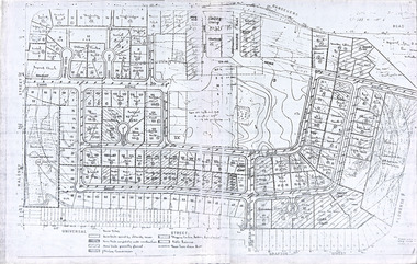
 Port Melbourne Historical & Preservation Society
Plan - US Military use of Port Melbourne Cricket Ground, Sverdup & Parcel, Architects and Engineers, 1940s
American military plan of Port Melbourne Cricket Ground, alterations to grandstand and rooms during WWII, 1940s.Plan drawn up by Sverdup & Parcel, Architects and Engineers.war - world war ii, sport - australian rules football, sport - cricket, sport - recreational grounds -
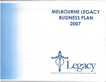 Melbourne Legacy
Booklet, Melbourne Legacy Business Plan 2007, 2007
This booklet outlines the objectives of Melbourne Legacy for the year 2007. The notations seem to indicate that a review was being done to determine how successful the the plan is, notes to make improvements and whether objectives are being achieved. The booklet sets out to give direction, on an annual basis, to the purpose of Legacy.Clear plastic cover, booklet bound with blue spiral binder, title printed in blue, Legacy symbol in blue bottom of front page, white pages.Red notations throughout the booklet, some yellow highlighter used.planning, annual summary -
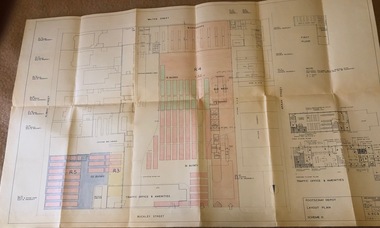 Melbourne Tram Museum
Drawing, Melbourne & Metropolitan Tramways Board (MMTB), "Footscray Depot - Layout Plan - Scheme II", 23/03/1960 12:00:00 AM
Drawings - coloured - titled "Footscray Depot - Layout Plan - Scheme II", signed by D. H. Eakins on 23-3-1960 showing a proposed layout of the depot following the closure of the Footscray system and the use of the entire block of land for buses. Has drawings of the Traffic Office and Amenities.trams, tramways, footscray, buses, depots -
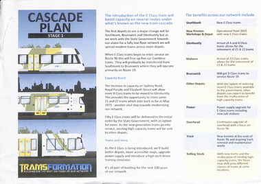 Melbourne Tram Museum
Pamphlet, Yarra Trams, "Cascade Plan Stage 1 - Tramsformation", c2012
Single A4 sheet - colour copy - titled "Cascade Plan Stage 1 - Tramsformation" giving details of the introduction of the E class trams and the impacts on the various depots, including notes on power supply overhead, track and rolling stock. Includes notes on the retirement of Z1 and Z2 trams.trams, tramways, e class, new trams, depots, z class -
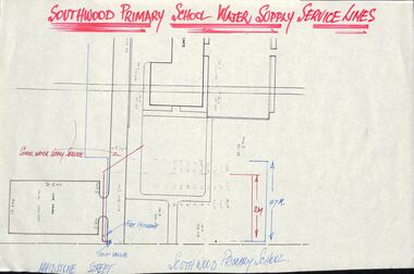 Ringwood and District Historical Society
Plan - Plans, Southwood Primary School, Ringwood, Collection of plans for water supply, sewerage and drainage
folder of paper plansSouthwood P.S. Water Supply, Sewerage & Drainage Plans. Permanent File. To be archived at P.R.O. when no longer required. -
 Robin Boyd Foundation
Document, Plan
Plan of Eastlakes development NSW (north of Botany) with home units, housing commission, shopping centre and public reserve between Gardeners RD, Universal Street, Grafton Street, Florence Street and Maloney Street.Photocopy, double page taped on reverse. Handwritten and typewritten. -
National Wool Museum
Book, Report to the Australian Wool Board: A proposal for handling the Australian wool clip under an acquisition plan
"A proposal for handling the Australian wool clip under an acquisition plan." Report to the Australian Wool Board: - J S Smith, committee chairman. Includes a covering letter from J S Smith to Sir William Gunn.wool sales wool brokering wool marketing, australian wool board, wool sales, wool brokering, wool marketing -
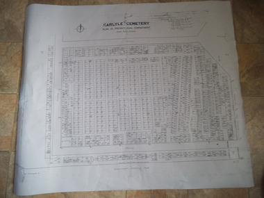 Rutherglen Historical Society
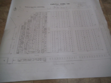
Carlyle Cemetery Map, Plan of Presbyterian Compartment, 1952
This is a map produced to attempt to bring order to the cemetery. Originally the layout was not well defined and it is difficult to use this plan to locate a particular grave, also the fact that not all graves are marked and foot paths are not defined has exacerbated this issue. Photocopy, White paper, black printing, black line work showing lot and compartment boundariesReferences Grid Survey points at 50 feet centres shown (as a cross with the reference mark number in brackets) Lot Number shown at left side of graves. Burial Number shown at right side of grave. Lots with unidentified burials show with dashed cross with in the lot. topographic survey, cadastral survey, carlyle cemetery, burials, graves, lot boundary, rotunda -
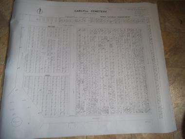 Rutherglen Historical Society
Carlyle Cemetery Map, Plan of Roman Catholic Compartment, 1952
This is a map produced to attempt to bring order to the cemetery. Originally the layout was not well defined and it is difficult to use this plan to locate a particular grave, also the fact that not all graves are marked and foot paths are not defined has exacerbated this issue. Photocopy, White paper, black printing, black line work showing lot and compartment boundariesReferences Grid Survey points at 50 feet centres shown (as a cross with the reference mark number in brackets) Lot Number shown at left side of graves. Burial Number shown at right side of grave. Lots with unidentified burials show with dashed cross with in the lot. topographic survey, cadastral survey, carlyle cemetery, burials, graves, lot boundary, rotunda -
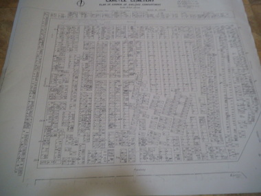 Rutherglen Historical Society
Carlyle Cemetery Map, Plan of Church of England Compartment, 1952
This is a map produced to attempt to bring order to the cemetery. Originally the layout was not well defined and it is difficult to use this plan to locate a particular grave, also the fact that not all graves are marked and foot paths are not defined has exacerbated this issue. Photocopy, White paper, black printing, black line work showing lot and compartment boundariesReferences Grid Survey points at 50 feet centres shown (as a cross with the reference mark number in brackets) Lot Number shown at left side of graves. Burial Number shown at right side of grave. Lots with unidentified burials show with dashed cross with in the lot. topographic survey, cadastral survey, carlyle cemetery, burials, graves, lot boundary, rotunda -
 Rutherglen Historical Society
Carlyle Cemetery Map, Plan of Wesleyan Compartment, 1952
This is a map produced to attempt to bring order to the cemetery. Originally the layout was not well defined and it is difficult to use this plan to locate a particular grave, also the fact that not all graves are marked and foot paths are not defined has exacerbated this issue. Photocopy, White paper, black printing, black line work showing lot and compartment boundariesReferences Grid Survey points at 50 feet centres shown (as a cross with the reference mark number in brackets) Lot Number shown at left side of graves. Burial Number shown at right side of grave. Lots with unidentified burials show with dashed cross with in the lot. topographic survey, cadastral survey, carlyle cemetery, burials, graves, lot boundary, rotunda -
 Ringwood and District Historical Society
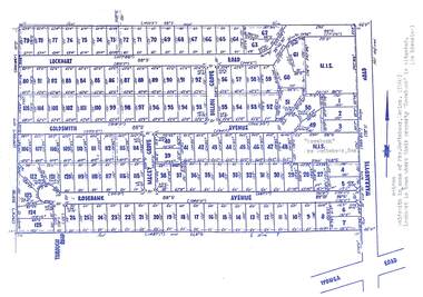
Map, Subdivision Plan - Rosebank Avenue area, North Ringwood, Vic. - circa 1960s
Single page plan printed on green background showing allotments included in un-named subdivision layout surrounding "Rosebank" property, Warrandyte Road, Ringwood North. Subdivision includes Through Road, Rosebank Avenue, Macey Grove, Goldsmith Avenue, Dillon Grove, Lockhart Road, and Warrandyte Road.Typewritten notation against "Rosebank" property - "Mrs Godbehear, Snr.". "Goldsmith is maiden name of Mrs. Godbehear, Senior. (1960). Lockhart is town where their property "Rosebank" is situated. (In Riverina)". -
Federation University Historical Collection
Document - Report, Ballarat School of Mines and Industries Ballarat Limited 1995 College Plan, 01/1995
Blue covered report stapled at top left corner. Contents include a profile and focus of the School, Training Context, Regional Influences, training priorities, budget summary, organizational structure, corporate goals and objectives, Statement of purpose and key initiatives, Activity Profiles, Performance monitoring, Capital Works Plan. ballarat school of mines, objectives, social and community studies, building studies, rural studies, business studies, vocational arts, hospitality studies, applied science, further education, tafe, technical and further education, ararat campus, ararat prison, langi kal kal prison, ron wild, keith boast, planning services, ross furness, human resources, john kemp, david nicholson, ann mccaggrey, brian webber, martin hill, max palmer, brian mclennan, mary molloy, david flintoff, andrew sullivan, ross holton, hoticulture, bill king, plumbing, les comley, alistair heighway, verity higgins, michael bracher, bob o'shea, derek wren, frank sordello, john ferrier, viginia fenelon, lorraine yeomans, terry o'neil, irene warfe, david manterfield, rocky hazlett, mark bevelander, kevin martin, ian harris, performance monitoring, campus plan -
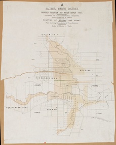
 Bacchus Marsh & District Historical Society
Map, Lerderderg District Proposed Irrigation and Water Supply Trust (A). Plan showing boundaries of Trust District
The 1886 Irrigation Act in Victoria introduced the first legislation in Australia designed to enable the creation of a detailed scheme for agricultural irrigation. Part of the legislation saw the use of government funds for local irrigation projects. These local projects were managed by local irrigation trusts. The Lerderderg Irrigation and Water Supply Trust] was formed in 1890. This map depicts the proposed area of the Trust.Printed paper map of the proposed Lerderderg District Irrigation and Water Supply. Plan showing boundaries of Trust District. The Lerderderg District lies within the Parishes of Korkuperrumul and Merrimu in the County of Bourke. At the top of the map above its title is the letter 'A; in capital lettering. Scale: 40 Chains = 1 inch.irrigation, water supply, lerderderg irrigation and water supply trust -
 Melbourne Legacy
Document, Junior Legacy Endowment Plan, 1960s
A copy of a letter addressed to Junior Legacy to be used by donors when donating money to the Endowment Plan. Was compiled in a folio of proforma stationery. Junior Legacy Club the name of Melbourne Legacy for many years. A similar set of proformas are at 00338.A record of forms and items used in Legacy's business practices in the 1960s.Pale yellow letter proforma to Junior Legacy with spaces for date and donor information, pasted on brown paper from a folio of forms and brochures from the 1960s.Pencil mark saying 1960/1proformas, stationery, forms -
Clunes Museum
Plan - PLANS, YUNCKEN, FREEMAN & FREEMAN, CLUNES PUBLIC HOSPITAL ALTERNATIONS & ADDITIONS, 1935
SHEET OF PAPER, HAND DRAWN PLANS IN BLACK INK, INCLUDES ELEVATION VIEWSWRITTEN IN PENICL ON REVERS "PLANS RECONSTRUCTION CLUNES HOSPITAL (COPY) 1935clunes public hospital, yuncken, freeman -
 University of Melbourne, Burnley Campus Archives
Plan, Burnley Gardens 1945, 1945
"Plan of School of Horticulture. Burnley Gardens 1945," handwritten on reverse. Also, photocopy of part of it, enlarged.Plan of School of Horticulture. Burnley Gardens 1945, handwritten on reverse.burnley gardens, burnley school of horticulture -
 Melbourne Tram Museum
Document - Report, Australian Railway Union and others, "Melbourne Transportation Study - The Transportation Plan - 1970 to 1985", 1970
A series of four reports regarding the implementation and work done by the Metropolitan Transportation Committee completed in 1969. Prepared by Australian Railways Union, Boilermakers and Blacksmiths Society, Tramway Employees' Association and the Amalgamated Engineering Union. .1 - Bulletin No. 1 - 18 white sheets duplicated - looks at the plan, results, services, motor vehicles and public transport. .2 - Bulletin No. 2 - 14 - yellow sheets duplicated - The Press and the Plan. .3 - Bulletin No. 3 - 10 pink sheets duplicated - The Underground loop - to be or not to be. .4 - Report on the Teach-in held on 15/5/1970 - 3 green sheets stapled - refers to the above documents and the 4th - The MMTB - its past and present - what of its future (that was in course of preparation)trams, tramways, public transport, history, mmtb, transportation plan, unions, melbourne, railways -
 Federation University Historical Collection
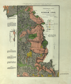
Plan, Durham Lead, 1870
Geological Map of portions of Durham Lead. durham lead, reginald a.f. murray, plan, garibaldi, garibaldi company, geology, chryseis company, hardies hill, city of manchester company, williamson's creek, south grenville company, enfield company, pioneer company, duke of northumberland company, monmowth gully, extinct volcano crater, mount mercer basalt -
Ringwood and District Historical Society
Book - Eureka Plan, Farmer, Mr, Eureka Plan, c. 1930
Created to assist in promotion and sale of land near Ringwood Railway station, following completion of the electric rail to Ringwood..Book containing details of seven delightful and valuable Ringwood properties - Bestpart, Paradur, Hill Top, Greenwood, Creek, Station and School estates. The book has 16 photos and 20 plans and 20 pages. There are multiple copies of pages 20x2; 19x2; 18x4; 17x4 and 20x2. +Additional Keywords: Farmer, Mr -
 Ringwood and District Historical Society
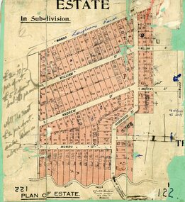
Map, Subdivision Plan, Loughnans Road, Ringwood - circa 1922
Green card with cut-out map of residential allotments, some marked "sold". "Plan of Estate" includes Wonga Road, Loughnans Road, William Street, Andrew Street, Harrison Street, and Munro Street, Ringwood. (Surrounding area is part of Ringwood Park Estate featured in seperate 1922 auction flyer).Handwritten notations - (northern section) {£2-10/- per foot. £5 deposit bal £1 per month} All the rest £2 per foot, value same as above. Licensed Surveyors - W.J. & A.W. Kenhardt, 352 Collins Street, Melbourne. -
 Kew Historical Society Inc
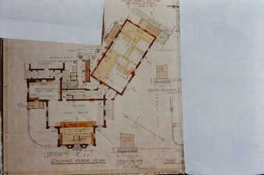
Slide - Architectural Drawing, Kew Public Offices, 1887
A civic campaign for new public offices developed in Kew in the 1880s. After much deliberation, the location chosen was the junction of Bulleen and Cotham Roads. The buildings were designed by George Watson and John Henry Harvey, architects within the Department of Public Works (Victoria). Building was commenced in 1887, and after one year, the buildings were opened. The Post Office was transferred to the new Commonwealth Government in 1901. The Police Station and Court House, sold by the Victorian Government to the City of Boroondara in 2007, are now a community cultural centre and performing arts venue.The buildings were listed on the Victorian Heritage Register Register (HO885) in 1991. They are historically and architecturally significant to the State Of Victoria because Watson and Harvey's designs exhibit diversity in integrating civil offices, they accommodate the apex of road junctions, and they demonstrate a departure from the contemporaneously favoured High Victorian Classical to the Queen Anne style in the design of civic buildings. 35mm colour transparency of an original plan by George Watson and John Henry Harvey, architects of the Department of Public Works (Victoria), in 1887 for New Public Offices at Kew. This plan was copied by the donor from an original held at the Commonwealth Archives in Brighton (Vic). The copy was made to illustrate a report that the donor made on ‘The functional planning design, building materials and construction methods of the Kew Post Office’ as part of course work at RMIT.GROUND FLOOR PLANkew court house, kew police station, kew post office, architectural drawings, khs - slides, new public offices -- kew (vic.), architecture — queen anne style -
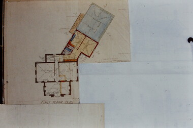 Kew Historical Society Inc
Slide - Architectural Drawing, Kew Public Offices, 1887
A civic campaign for new public offices developed in Kew in the 1880s. After much deliberation, the location chosen was the junction of Bulleen and Cotham Roads. The buildings were designed by George Watson and John Henry Harvey, architects within the Department of Public Works (Victoria). Building was commenced in 1887, and after one year, the buildings were opened. The Post Office was transferred to the new Commonwealth Government in 1901. The Police Station and Court House, sold by the Victorian Government to the City of Boroondara in 2007, are now a community cultural centre and performing arts venue.The buildings were listed on the Victorian Heritage Register Register (HO885) in 1991. They are historically and architecturally significant to the State Of Victoria because Watson and Harvey's designs exhibit diversity in integrating civil offices, they accommodate the apex of road junctions, and they demonstrate a departure from the contemporaneously favoured High Victorian Classical to the Queen Anne style in the design of civic buildings. 35mm colour transparency of an original plan by George Watson and John Henry Harvey, architects of the Department of Public Works (Victoria), in 1887 for New Public Offices at Kew. This plan was copied by the donor from an original held at the Commonwealth Archives in Brighton (Vic). The copy was made to illustrate a report that the donor made on ‘The functional planning design, building materials and construction methods of the Kew Post Office’ as part of course work at RMIT.FIRST FLOOR PLANkew court house, kew police station, kew post office, architectural drawings, khs - slides, new public offices -- kew (vic.), architecture — queen anne style -
 Melbourne Tram Museum
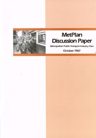
Document - Report, The Met, "MetPlan discussion Paper - Metropolitan Public Transport Industry Plan, Oct. 1987
Report or discussion paper, 76 pages printed on off white paper, with card cover, centre stapled, titled "MetPlan discussion Paper - Metropolitan Public Transport Industry Plan - October 1987". Prepared by Metropolitan Transit authority and Ministry of Transport, signed by the Kevin Shea as Managing Director the MTA. Has a summary of contents, table of contents, many figures and tables (see images 2 and 3). Looks at the current policies and objectives, Melbourne's urban development and public transport system, financial and staff picture, future public transport needs and planning the development of a future service. Gives details of book designers and printers on the last page. Second copy from donation of John Prideaux added 24-6-2016trams, tramways, metplan, minister for transport, public transport, the met, mta, melbourne -
Ballarat Tramway Museum
Newspaper, The Courier Ballarat, "Plan for return of Trams", 16/01/1980 12:00:00 AM
Newspaper clipping from The Courier, Ballarat, Wednesday 16/1/1980, titled "Plan for return of Trams". Item describes a handwritten proposal that had been sent to the City of Ballarat by a Mr Daryl Jones for a tramway from the Botanic Gardens to Sovereign Hill. Proposals to be reviewed by Council, who had not heard of them before.tramway proposals, sovereign hill -
 Bendigo Historical Society Inc.
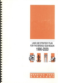
Book - LAND USE STRATEGY PLAN FOR THE BENDIGO SUV-REGION 1990-2020, 1991
Land Use Strategy Plan for the Bendigo Sub-Region, 1990 - 2020. Bendigo 2020 Strategy. Prepared by three consulting firms for the Loddon-Campaspe Regional Planning Authority Inside front cover are: 1 Cover sheet, 3 stapled reports covering Bendigo 2020 land use strategy plan, Issues Report, Environment, also a 5 page booklet planning for the future with information and maps.Loddon-Campaspe Regional Planning Authoritybendigo, planning, 2020 strategy. -
 Bacchus Marsh & District Historical Society
Map, Bacchus Marsh District (A). Proposed Irrigation and Water Supply Trust. Plan shewing boundaries of Trust District
The 1886 Irrigation Act in Victoria introduced the first legislation in Australia designed to enable the creation of a detailed scheme for agricultural irrigation. Part of the legislation saw the use of government funds for local irrigation projects. These local projects were managed by local irrigation trusts. The Bacchus Marsh Irrigation and Water Supply Trust was formed in 1889. This map depicts the proposed area of the Trust.Printed paper map of the proposed Bacchus Marsh Irrigation and Water Supply district. Circa 1889. Plan showing boundaries of Trust District. The District lies within the Parishes of Korkuperrimul, Merrimu, Parwan and Gorrockburkchap in the Counties of Bourke and Grant. At the top of the map above its title is the letter 'A; in capital lettering. Scale: 40 Chains = 1 inch.irrigation, water supply, bacchus marsh irrigation and water supply trust -
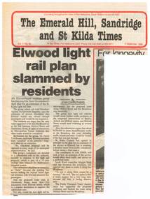 Melbourne Tram Museum
Newspaper, The Emerald Hill, Sandridge and St Kilda Times, "Elwood light rail plan slammed by residents", 8/09/1988 12:00:00 AM
Newspaper clipping from "The Emerald Hill, Sandridge and St Kilda Times", titled "Elwood light rail plan slammed by residents", 8 September 1988, about the proposed extension of the St Kilda Light rail line into Elwood; the residents using such terms as appalled, ridiculous, futile, traffic problems, though the City of St Kilda was supportive.trams, tramways, st kilda, elwood, light rail, new tramway -
Federation University Historical Collection
Book, The Australian Assistance Plan in he Central Highlands Region (Masters Thesis), 1979
Thesis (M.A.) - La Trobe University, 1979. Submitted to the Politics Dept. This thesis is an analysis of the Australian Assistance Plan as a substantive policy. Framed to achieve regional coordination of social develpment and social welfare, the key elements in the policy were participation, comunity develiopment and regional accountability. Blue hard covered thesis undertaken at LaTrobe University Melbourne frank hurley, thesis, pulic welfare, central highlands of victoria, ballarat, ararat, local government, politics, strategy -
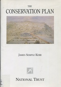 Surrey Hills Historical Society Collection
Book, The Conservation Plan: a guide to the preparation of conservation plans for places of European Cultural Significance, 1996
This guide is about gathering, analysing and assessing information that bears upon policy decisions and on the process of making those decisions. It offers a common ground for debate, a method and a common language to help resolve differences and achieve a balance between the old and the new. The result of these processes is a conservation plan.historic sites - australia - conservation and restoration, historic buildings - conservation and restoration - ausation of places of cultural significancetralia, monuments - australia - conservation and restoration, australia/icomos charter for the conserv