Showing 17872 items
matching show
-
 Glenelg Shire Council Cultural Collection
Photograph - Photograph - Sheet of 6 contact prints, c. 1964
Port of Portland Authority ArchivesFront: 28-10-64 127 28-10-64 126 28-10-64 133 28-10-64 115 28-10-64 126 28-10-64 128 - in white under each print Back: 133 (ticked) 128 (crossed out) in pencilport of portland archives -
 Ballan Shire Historical Society
Map - Map. Bungal, Department of Lands and Survey, Bungal, County of Grant, 09/09/1926
A map of Bungal in the 1920's showing the allotments, and the size, with the names of the residents. It shows the roads and the Western and Eastern Moorarbool River, and the Whipstick State Forest.Cream coloured map of Bungal in the County of Grant, bounded by the the East Moorarbool River on the East, and the State Forest on the South. It is marked with the scale of chains and the number L.358. Lithographed at the Department of Lands and Survey. Melbourne by W. J. Butson on 9.9.1926. It shows the land allotments with names of owners.Coloured pen marks and circled numbers on various areas. Price 2 shillings marked on bottom right hand edge.bungal, kerrit bareet, egerton, lal lal, borhoneyghurk, bungeeltap, ballark, yaloak, gorong, moorarbool west -
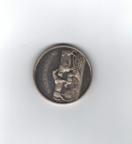 Warrnambool and District Historical Society Inc.
Medal, Villiers and Heytesbury Agricultural Association (Daniel Hourigan 1877), C 1877
This medal was awarded at the Villiers and Heytesbury Agricultural Association Annual Show to Daniel Hourigan in 1877 for his yearling colt by 'Prince of the Isles'. The formation of the Villiers and Heytesbury Agricultural Association arose out of a meeting at Woodford in 1853 and the first Show was held in Warrnambool in 1855 on a green bound by Fairy, Henna and Koroit Streets. It was held there until 1875 when it moved to the present Warrnambool Showgrounds in Koroit Street. At the 37th Annual Show in 1890 Warrnambool held its first Grand National Show, a title granted by the Chamber of Agriculture in Victoria. The Villiers and Heytesbury Agricultural Association became known as the Warrnambool Agricultural Show in 1911. Daniel Hourigan was a farmer, road contractor, poundkeeper and auditor who lived in the Tower Hill area in the 19th century. This medal is of considerable interest as it is a memento of the Villiers and Heytesbury Agricultural Association Annual Show in the 19th century. Annual Agricultural Shows have been an important feature of agricultural life in Victoria since the early days of European settlement and a feature of agricultural life in the Warrnambool district since the 1850s. The medal is also of great interest because it was awarded to Daniel Hourigan, a prominent settler in the Warrnambool district in the 19th century. .1 Circular silver disc with image of horse, bull, sheep, wheat sheaf and plough on the reverse with script around edge of obverse with awardees details engraved in the centre. Edge of the medal is plain. .2 Square maroon leather case with small metal clasp and hinge. Lined on the interior with blue velvet and cream silk.Obverse :" Warrnambool" engraved above image of cattle. W J Taylor London Reverse : Villiers & Heytesbury Agricultural Association in low relief around the edge. 1st prize awarded to Daniel Houriganfor yearling colt , "Prince of the Isles Annual Show 10th October 1877.warrnambool, villiers and heytesbury, daniel hourigan, prince of the isles, 1877, villiers & heytesbury agricultural show -
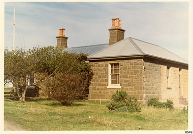 Flagstaff Hill Maritime Museum and Village
Photograph - Historical, Flagstaff Hill, The Lighthouse Keeper’s Cottage showing re-roofing carried out by Council, 1970s
The coloured photograph shows the Lighthouse Keepers' Quarters at Flagstaff Hill, Warrnambool. The building was erected in the 1850s on Middle Island, Lady Bay. It was relocated to its current location in the late 1870s along with the two lighthouses, the chart room and the privy. The Warrnambool City Council replaced the iron roof on the cottage in the 1970s and further work has since been carried out. The picture shows the poor condition of the stonework on the right hand side of the cottage. After the cottage ceased to be used by lighthouse keepers, it was rented out by various organisations and later became disused. The Historical Society requested the re-connection of power. The right hand side of the cottage was repurposed for use by Flagstaff Hill Maritime Museum and Village. in the 2020s it was restored and fitted out as the Alexander Farncombe room, which is used for temporary exhibitions. This photograph, a print, is one of a set of five that show the site of Flagstaff Hill. It is presumed to have been taken by John Lindsay, Founding Director of Flagstaff Hill Maritime Museum and Village. One of the photographs in the set has the pencil inscription "Photo J Lindsay". It was taken in the early 1970s during the initial stages of the development of Flagstaff Hill as a Museum and Maritime Village. The photographs belonged to the donor's grandparents, who lived in the Warrnambool district of Allansford/Naringal. The photograph is a record of the Lighthouse Keepers' Quarters at Flagstaff Hill Maritime Museum and Village before its development and opening in 1975. It shows the condition of the building at the time and some of the recent re-roofing. The photograph is significant for recording the condition of the original heritage listed building at that point in time.Coloured photograph, glassy print, one of a set of five. Photograph shows the Lighthouse Keepers' Quarters, focused on the Assistant's Quarters on the right. It shows the a new iron roof that had been installed by the Warrnambool City Council, and the condition of the bluestone,walls. There are clay chimney pots on the two chimneys. A set of steps are at the entry on the right hand side. The flagstaff is on the left of the photograph. The photograph's paper has the printer's watermark on the back. The early 1970s picture is presumed to have been photographed by John Lindsay, Warrnambool.Label on the back: "THE BLUESTONE COTTAGE SHOWING RE-ROOFING CARRIED OUT BY COUNCIL. The Historical Society has requested Council to have S.E.C. power re-connected"flagstaff hill maritime museum and village, warrnambool, maritime museum, shipwreck coast, 1970s, photograph, lady bay, flagstaff hill site, john lindsay, cannon emplacement, middle island, flagstaff, lighthouse keepers' quarters, lighthouse keepers' residence, alexander farncombe, re-roofing, s.e.c. connection -
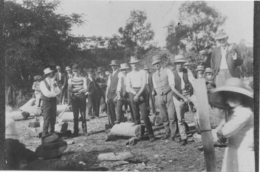 Halls Gap & Grampians Historical Society
Photograph - B/W, C early 1900s
The photo shows a woodchopping competition in an unknown location in the Grampians. The identity of the people in the photo is unknown.The photo shows a large group of men standing in a clearing , around a cut log with a crow bar lodged in it. Other similar logs lie around the clearing. Many of the men are holding axes. There is a woman in a large hat standing beside a post in the right foreground and a man standing on a rock or log behind her with a pipe in his mouth.recreation, woodchopping competition -
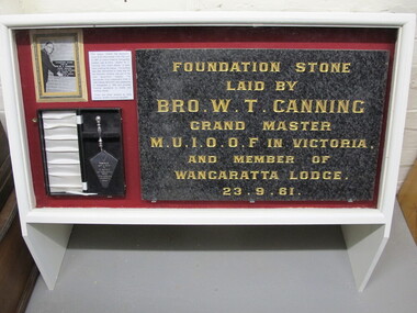 Wangaratta Historical Society
MUIOOF Foundation Stone, MIOOF Foundation Stone, Early 1960's
This photo shows the foundation stone that was erected on the Manchester Unity Hall site when it was built in 1961. The building was demolished to make way for the Local Government Center, presently housing the Rural City of Wangaratta. The first meeting of Manchester Unity members was held in Wangaratta 1863. This was an important sociocultural group in Wangaratta during the mid 20th Century.This photo shows the foundation stone that was erected on the Manchester Unity Hall site when it was built in 1961. The building was demolished to make way for the Local Government Center, presently housing the Rural City of Wangaratta and other government departments.manchester unity hall wangaratta muioof -
 Ringwood and District Historical Society
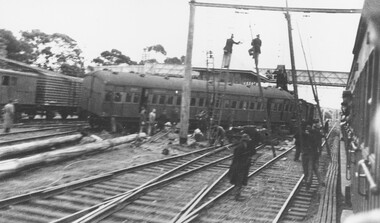
Photograph, Ringwood railway station precinct - derailment 22/6/1945
A porter illegally in the signal box moved the points under a train coming into the south platform from a siding. The 5th carriage took two lines as shown, and brought down the overhead stanchions over both the passenger and goods lines. For about 36 hours, the service beyond Mitcham was maintained by steam trains connecting with electrics at Mitcham. Men are pictured putting up temporary overhead stanchions over the passenger lines around 10 a.m. on Saturday 22/6/1945 and another photograph shows the steam crane near the signal box lifting the Melbourne end of the derailed carriage. Accompanying typed sheet reads, "...shows the steam crane about outside the signal box lifting the Melbourne end of the derailed carriage". -
 Bendigo Military Museum
Photograph - CENOTAPH RESTORATION WORKS, C. 1987 - 1988
This is the sixth in a series beginning with Cat No 8255 showing the progress towards the Restoration of the Bendigo Cenotaph over the Bendigo Creek. All in the photos are Bendigo RSL Committee personal except Councilor Mary Hall. .1) People from left to right. Rex Willis, Roy Thurlow, Max O' Haloran, Jack Plant, Cr Mary Hall. .2) People from left to right, Jack Barnes, Rex Willis, Max O' Haloran, Norm Smart, Cr Mary Hall, unknown. .3) The wording on the sign. City of Bendigo. Project: Restoration of the Cenotaph. Consultants. Architect. Robinson LOO WYSS & Schneder PTY LTD. Engineer. R Kelleher & Associates. Bridgework. TE & FA HPD. Cenotaph Stone Mason. Lodge Bros PTY LTD. Builder. HF. Yuncken PTY LTD Bendigo..1) Photograph colour, shows 5 people one with a mallet on the Bendogo Cenotaph. .2) Photograph B&W shows 6 people on the same structure. .3) Photograph colour shows signage at the Cenotaph restoration site..1) On rear in red pen, "Cenotpah - laying last brick", stamped on rear, "17 March 88". .2) On rear in blue pen, "March 88". .3) On rear in red pen, "Renovating Cenotaph Dec 87 - taken by Frank Thomas"brsl, smirsl, cenotaph, bendigo -
 Mont De Lancey
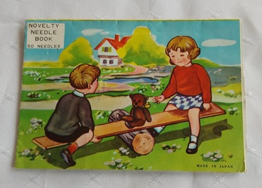
Functional object - Novelty Needle Book, Unknown
A home sewing needle kit. These paper sleeved novelty needle books were available in the late 19th Century. They were often free as a promotional give-away. In the 1900's they were colourful and fun.A vintage Novelty Needle Book made in Japan with 50 needles mounted inside a pop up card. The needles are presented in gold and red strips attached to a coloured card depicting two small children playing on a see-saw with their teddy bear in a garden. Five needles are missing. The back of the card is yellow and shows a girl holding a red rose.'Novelty Needle Book 50 Needles' is printed on the front of the card which shows two children playing on a see-saw with their teddy bear. 'Made in Japan' is printed at the bottom right on the front of the card.sewing equipment, sewing, sewing needles -
 City of Kingston
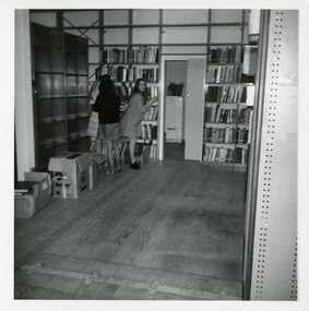
Photograph - Black and white, c.1973
This photograph shows a library interior with three women in the back corner. Black and white photograph of the interior of a library. There are empty shelves along the left hand wall with boxes on the floor in front of them. Three women are standing in the back corner, two facing away from the camera and one looking towards it. An open door shows a refrigerator in another room. The back wall is shelved with books. There is a large amount of open floor space in the foregroundPrinted in grey ink: | 526B / 15.11.78library, libraries -
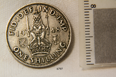 Flagstaff Hill Maritime Museum and Village
Coin, 1948
Coin, One Shilling, dated 1948. Obverse shows George V1, Reverse shows a loin with sword and sceptre sitting on a crown.. flagstaff hill, warrnambool, shipwrecked-coast, flagstaff-hill, flagstaff-hill-maritime-museum, maritime-museum, shipwreck-coast, flagstaff-hill-maritime-village, one shilling, coin, british currency -
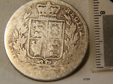 Flagstaff Hill Maritime Museum and Village
Coin, 1845
Coin, Half Crown, dated 1845. Obverse shows the "Young Head" of Queen Victoria. Reverse shows British Coat of Arms.flagstaff hill, warrnambool, shipwrecked-coast, flagstaff-hill, flagstaff-hill-maritime-museum, maritime-museum, shipwreck-coast, flagstaff-hill-maritime-village, half crown, coin, british currency -
Clunes Museum
Map, DEPARTMENT OF MINES, Untitled, c1859
All maps show names and locations of mines operating in the district (see reference section link to article).1 Map of Creswick Clunes - lists 45 mines in the Clunes enlargement and 100 mines in the Creswick enlargement .2 Department of Mines map of Clunes Creswick and shows the McDonald & Co. Pre-emptive area. Indexes for quartz and alluvial mine locations .3 Topographical map Ref GF23 Clunes Mt. Greenock Talbot.1 360 Scale 1:2500 .2 303/59 33 hand written in ink "received 15 October 1859" signed by R Broughton, James Stevenson - District Mining Surveyor .3 40 chains to an Inchgold mining, dept of mines -
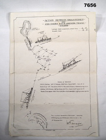 Bendigo Military Museum
Map - BATTLE MAP - SYDNEY EMDEN, Possibly 1928
This is a medium size poster. It is drawn in black ink. It shows an image of HMAS SYDNEY, SS BURESK (Collier) and SMS EMDEN. It shows the tracks the two ships took through the battle. It shows dotting lines throughout the drawing - possibly indicating when shots were exchanged. It shows a list in the centre, showing basic specs of the two warships and their battle casualties. It also shows relative positions of Keeling Island and Direction Island.ww1, sms emden, hmas sydney -
 Lakes Entrance Historical Society
Photograph - Woodsedge Art Centre Colour Gang Art Show, Lakes Post Newspaper, 4/04/1991 12:00:00 AM
Woodsedge Art Centre Colour Gang Art Show Frank Powell Richard Peach ABC radio Sale Grace Jobling Pres Newayung Debbie Heystratten Stephen Smith Lawrence Licctone Lakes Entrance VictoriaBlack and white photograph at Woodsedge Art Centre Colour Gang Art Show Frank Powell Richard Peach ABC radio Sale Grace Jobling Pres Newayung Debbie Heystratten Stephen Smith Lawrence Licctone Lakes Entrance Victoriaarts, exhibition -
 Halls Gap & Grampians Historical Society
Photograph - B/W
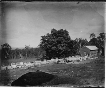
The photos show the Russell bee-hives at Roses Gap. The tree near the hut is the present site of Chinaman Lodge home. One of the copies is a transparency located at No 243 in the slide box.The photos show a group of bee-hives lined up in front of a timber shed. The hives and shed are in a clearing. There is a large tree near the shed and the clearing is edged with thick bush in the background. The two copies are of two photos taken at slightly different angles and distances from the shed.misc industries, bee-keeping, scenery, cherrypool -
 Halls Gap & Grampians Historical Society
Photograph - B/W, C 1900s
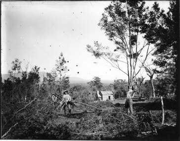
The photo shows wattle-bark stripping, taking place at Roses Gap (western end). The identity of the men is unknown.The photo shows three men in a cleared area of bush, one is standing holding a bundle of wattle bark, another is behind and to the left of him also holding bark and a third is standing to the right and is scrapping bark from a tree above his head with a long stick . There is a hut in the background, the right side of which is just a frame. timber industries, wattlebark stripping, scenery, roses gap -
Federation University Historical Collection
Plan - Plan (copy), Melbourne Road Ballaarat, 1857
This map shows the vicinity of the site of the Eureka Stockade. A3 black and whole photocopy of a plan of Ballarat's Melbourne Road. The plan shows Melbourne Road, Proposed Melbourne Road (later Eureka Street), Chamberlain Street, Queen Street, Allotments between Rodier Street and Stawell Street (William Collard Smith, J & T Oddie, F.A. Edward A. Wynne, David Fitzpatrick, Robert Walsh, Charles Spencer, Alfred Lester, Free Trade Hotel)william collard smith, oddie, wynne, fitzpatrick, walsh, spencer, lester, free trade hotel -
 Halls Gap & Grampians Historical Society
Photograph - B/W, C 1919-1920
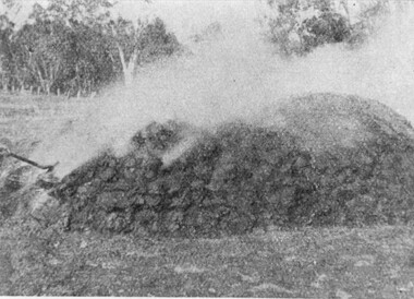
Photo has been taken from Stawell Sec. College magazine 'The Pinnacle' published 1920Photo shows a smouldering pile of charcoaltimber industries, charcoal burning -
 Halls Gap & Grampians Historical Society
Photograph - B/W
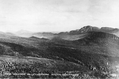
This is a photo of the Wannon Valley, looking south. It may be a copy of a postcard.The photo shows a valley with a range in the background."The Wannon Valley, looking south, Grampians. No. 29" inscribed on bottom of photo.scenery, grampians ranges -
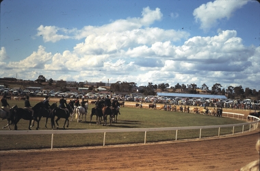 Bendigo Historical Society Inc.
Slide - BENDIGO SHOW, 1970
Slide.Bendigo Show. Equestrian events on the arena.slide, bendigo, bendigo show., bendigo show. -
Clunes Museum
Negative - NEGATIVES
LEONARD CARTER WAS A PHOTOGRAPHER. HE ORININALLY LIVED IN CLUNES AND LATER IN APOLLO BAY. FAMILY HOME WHERE ROBERT CAMPBELL NOW LIVES.1 NEGATIVE OF THE ROMSEY SHOW - 1907local history, photography, photographs, negative, -
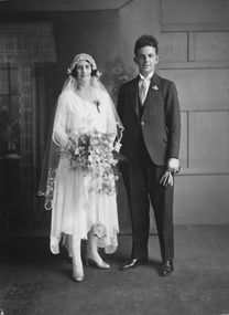 Stawell Historical Society Inc
Photograph, Mr John Alexander Hall & Miss Margaret Mary Frawley wedding 1930, 1930
Hall Wedding 1930. John Alexander Hall & Margaret Mary Frawley 1930Shows a Bride and Groom in Studio SettingOn Rear: MARGARET MARY ( FRAWLEY) {13.12} with a line through the numbers. JACK { MAY } Ccrossed out (JOHN ALEXANDER) d. 13 /12/1980 Married 1930stawell portrait -
Federation University Art Collection
Bookplate, 'Ex Libris'
After a quiet period, interest in bookplates in Australia began to increase in the early 1970s, Entrepreneurial art and book collectors such as Edwin Jewell and others commissioned multiple Bookplate designs from a range of well known fine artists. At a 1997 meeting in Melbourne of the Ephemera Society of Australia Edwin Jewell and others announced the formation of the Australian Bookplate Society. The society was instrumental in promoting the art of the bookplate through establishment of the Australian Bookplate Design competition. The competition includes a design award for secondary schools students.The print shows a black and white platypusAmy B at bottom rightbookplate, printmaking, australian bookplate design award, keith wingrove memorial trust -
Federation University Art Collection
Book Plate, 'Ex Libris'
After a quiet period, interest in bookplates in Australia began to increase in the early 1970s, Entrepreneurial art and book collectors such as Edwin Jewell and others commissioned multiple Bookplate designs from a range of well known fine artists. At a 1997 meeting in Melbourne of the Ephemera Society of Australia Edwin Jewell and others announced the formation of the Australian Bookplate Society. The society was instrumental in promoting the art of the bookplate through establishment of the Australian Bookplate Design competition. The competition includes a design award for secondary schools students.The print shows a bird with a long beakKHYLE along right hand edgeprintmaking, bookplate, australian bookplate design award, keith wingrove memorial trust -
Federation University Art Collection
Bookplate
After a quiet period, interest in bookplates in Australia began to increase in the early 1970s, Entrepreneurial art and book collectors such as Edwin Jewell and others commissioned multiple Bookplate designs from a range of well known fine artists. At a 1997 meeting in Melbourne of the Ephemera Society of Australia Edwin Jewell and others announced the formation of the Australian Bookplate Society. The society was instrumental in promoting the art of the bookplate through establishment of the Australian Bookplate Design competition. The competition includes a design award for secondary schools students.The print shows a kangaroo alongside a fenceChelsea Couzner bottom right hand cornerprintmaking, bookplate, australian bookplate design award -
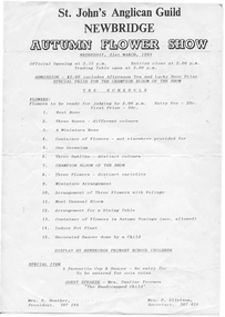 Tarnagulla History Archive
Flyer: Newbridge Flower Show, 1994
Donald Clark Collection.A flyer for the Newbridge Flower Show in 1993 -
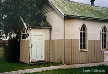 Melton City Libraries
Photograph, Front section of the Opportunity Shop, 1985
Rear of Church shows fibrolite sectionchurches -
Federation University Historical Collection
Photograph, Neville Bunning, Black and White Photgraphs of Campervan
Neville Bunning was a lecturer in Ceramics at the UniversityBlack and White photographs of Campervan and man. White envelope with handwritten note. .1 Shows van with roof popped and man beside the van. .2 Shows a man looking at the front of the van .3 Shows man in front of vanphotograph, black and white photograph, neville bunning, campervan, envelope -
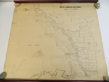 Kiewa Valley Historical Society
Map - Kiewa Valley, Parish Map of Mullindolingong, 12/10/1906
The map shows the names of people living in the parish of Mullindolingong in 1906. These people had leases or licences giving the reader an insight into the number of people in the area and an understanding of the size of their holdings. Infrastructure is also given including shops, schools, churches etc. Presumably it was used by the Ryder family.This map gives an historical insight into the parish of Mullindolingong as it names people and the infrastructure - roads, buildings etc. as it was in 1906. This enables the reader to compare the area at the time with other times and other places and to have an understanding of the early settlers in the area.This is a very old paper or parchment map with wooden rods top and bottom. The top rod has ribbons attached to enable hanging. The map shows the current leases and licences and when they were held by during this period, circa 1906.Mullindolingong County of Bogong. This plan has been prepared by The Most Reliable Data in the Possession of the Department up to the date of its Compilation. Information respecting Leases or Licences which await Final Completion is not recorded.parish of mullindolingong map; ryder family; early settlers;