Showing 1675 items
matching the grove
-
 Bendigo Historical Society Inc.
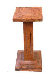
Decorative object - Display Pedestal
A wooden construction of three pieces. The lower piece is eleven centimetres square and two centimetres high, there's a one centimetre right angle edge then angled two centimetre long and rising one centimetre section, then there's half centimetre high and seven centimetre square flat section. The middle piece nineteen centimetres high and four centimetres square at the bottom tapering to three centimetres square at the top, each side has two eleven centimetre groves in it that start and finish four centimetres from each end. The upper piece is a smaller inverted copy of the lower piece, it has four centimetre square attached to the middle piece and an eight centimetre flat square on top. It has a clear coating applied to it which is deteriorating. woodwork, small display pedestal -
 Kew Historical Society Inc
Photograph - 'Mount Eri', 9 Highbury Grove, 1919
Subdivision plans are historically important documents used as evidence of the growth of suburbs in Australia. They frequently provide information about when the land was sold on which a built structure was subsequently constructed as well as evidence relating to surveyors and real estate and financial agents. The numerous subdivision plans in the Kew Historical Society's collection represent working documents, ranging from the initial sketches made in planning a subdivision to printed plans on which auctioneers or agents listed the prices for which individual lots were sold. In a number of cases, the reverse of a subdivision plan in the collection includes a photograph of a house that was also for sale by the agent. These photographs provide significant heritage information relating house design and decoration, fencing and household gardens.A photograph of Mount Eri, 9 Highbury Grove, an 11-room house for sale near the junction of Cotham and Glenferrie Roads. The substantial red brick, slate-roofed house and its location are not identified in the photograph, although the extent of the house is noted. It was described then as ‘well situated’ and close to 3 trams. Mathers, a financial agent in Cotham Road, placed advertisements about the sale of the property in The Argus in May and June 1919. The advertisement additionally refers to a billiard room and asserts that the house has every modern convenience. An annotation on the plan indicates that the house, with tennis court, was sold for £1960. Following extensive research, the house has now been conclusively identified, albeit extended and rendered. The house was originally built in the 19th century as a school and for much of the 20th century was used as a venue for receptions. -
 Kew Historical Society Inc
Photograph - 'Fernhurst', 13 Fernhurst Grove, 1978
George Wharton arrived in Melbourne in 1844. An architect and surveyor, he was appointed to lay out the 'Village of Kew' by N.A. Fenwick following the land sales of 1851. A protagonist for Kew's separation from the Boroondara District Road Board, he was elected chairman when Kew achieved municipal status in December 1860. His home, 'Fernhurst', was built in 1866 on eight acres in Studley Park, with a four-storey tower and pyramidal roof. The Italianate home was a prominent Kew landmark. It was demolished in 1979 and replaced by St Paul's College in 1980.Rare colour photograph of what was once a significant mansion in Kew.Original colour positive photograph (Kodak print) of 'Fernhurst' in 1978. Photographed by Stewart West in May 1978, one year before it was demolished, the photograph gives little idea of the large landholding once surrounding the house. Originally accessed from near the corner of Princess Street and Studley Park Road, its gardens had been subdivided in the 1900s and its footprint restricted to 13 Fernhurst Grove. Like many other grand houses, by the 1970s it had been converted into apartments. From the photograph, one can see that the house had retained many of its original features such as the distinctive tower and the wide bow-fronted verandah. The slates on the roof (apart from those on the tower) had been replaced by tiles and the cement render of the exterior painted white. Annotated reverse: "View of Fernhurst Home Taken from Street / 10"fernhurst, 13 fernhurst grove -- kew (vic.), george wharton, italianate architecture, vila maria society, st paul's school for the blind -
 Kew Historical Society Inc
Photograph - 'Fernhurst', 13 Fernhurst Grove, 1978
George Wharton arrived in Melbourne in 1844. An architect and surveyor, he was appointed to lay out the 'Village of Kew' by N.A. Fenwick following the land sales of 1851. A protagonist for Kew's separation from the Boroondara District Road Board, he was elected chairman when Kew achieved municipal status in December 1860. His home, 'Fernhurst', was built in 1866 on eight acres in Studley Park, with a four-storey tower and pyramidal roof. The Italianate home was a prominent Kew landmark. It was demolished in 1979 and replaced by St Paul's College in 1980.Rare colour photograph of what was once a significant mansion in Kew.Original colour positive photograph (Kodak print) of 'Fernhurst' in 1978. Photographed by Stewart West in May 1978, one year before it was demolished, the photograph gives little idea of the large landholding once surrounding the house. Originally accessed from near the corner of Princess Street and Studley Park Road, its gardens had been subdivided in the 1900s and its footprint restricted to 13 Fernhurst Grove. Like many other grand houses, by the 1970s it had been converted into apartments. From the photograph, one can see that the house had retained many of its original features such as the distinctive tower and the wide bow-fronted verandah. The slates on the roof (apart from those on the tower) had been replaced by tiles and the cement render of the exterior painted white. Annotated reverse: "Fernhurst from higher ground level side shot / 7"fernhurst, 13 fernhurst grove -- kew (vic.), george wharton, italianate architecture, vila maria society, st paul's school for the blind -
 Kew Historical Society Inc
Photograph - 'Fernhurst', 13 Fernhurst Grove, 1978
George Wharton arrived in Melbourne in 1844. An architect and surveyor, he was appointed to lay out the 'Village of Kew' by N.A. Fenwick following the land sales of 1851. A protagonist for Kew's separation from the Boroondara District Road Board, he was elected chairman when Kew achieved municipal status in December 1860. His home, 'Fernhurst', was built in 1866 on eight acres in Studley Park, with a four-storey tower and pyramidal roof. The Italianate home was a prominent Kew landmark. It was demolished in 1979 and replaced by St Paul's College in 1980.Rare colour photograph of what was once a significant mansion in Kew.Original colour positive photograph (Kodak print) of 'Fernhurst' in 1978. Photographed by Stewart West in May 1978, one year before it was demolished, the photograph gives little idea of the large landholding once surrounding the house. Originally accessed from near the corner of Princess Street and Studley Park Road, its gardens had been subdivided in the 1900s and its footprint restricted to 13 Fernhurst Grove. Like many other grand houses, by the 1970s it had been converted into apartments. From the photograph, one can see that the house had retained many of its original features such as the distinctive tower and the wide bow-fronted verandah. The slates on the roof (apart from those on the tower) had been replaced by tiles and the cement render of the exterior painted white. Annotated reverse: "Back view of Fernhurst / 8"fernhurst, 13 fernhurst grove -- kew (vic.), george wharton, italianate architecture, vila maria society, st paul's school for the blind -
 Kew Historical Society Inc
Photograph - 'Fernhurst', 13 Fernhurst Grove, 1978
George Wharton arrived in Melbourne in 1844. An architect and surveyor, he was appointed to lay out the 'Village of Kew' by N.A. Fenwick following the land sales of 1851. A protagonist for Kew's separation from the Boroondara District Road Board, he was elected chairman when Kew achieved municipal status in December 1860. His home, 'Fernhurst', was built in 1866 on eight acres in Studley Park, with a four-storey tower and pyramidal roof. The Italianate home was a prominent Kew landmark. It was demolished in 1979 and replaced by St Paul's College in 1980.Rare colour photograph of what was once a significant mansion in Kew.Original colour positive photograph (Kodak print) of 'Fernhurst' in 1978. Photographed by Stewart West in May 1978, one year before it was demolished, the photograph gives little idea of the large landholding once surrounding the house. Originally accessed from near the corner of Princess Street and Studley Park Road, its gardens had been subdivided in the 1900s and its footprint restricted to 13 Fernhurst Grove. Like many other grand houses, by the 1970s it had been converted into apartments. From the photograph, one can see that the house had retained many of its original features such as the distinctive tower and the wide bow-fronted verandah. The slates on the roof (apart from those on the tower) had been replaced by tiles and the cement render of the exterior painted white. Annotated reverse: "Front view of Fernhurst showing tower to advantage / 9"fernhurst, 13 fernhurst grove -- kew (vic.), george wharton, italianate architecture, vila maria society, st paul's school for the blind -
 Kew Historical Society Inc
Photograph - 'Fernhurst', 13 Fernhurst Grove, 1978
George Wharton arrived in Melbourne in 1844. An architect and surveyor, he was appointed to lay out the 'Village of Kew' by N.A. Fenwick following the land sales of 1851. A protagonist for Kew's separation from the Boroondara District Road Board, he was elected chairman when Kew achieved municipal status in December 1860. His home, 'Fernhurst', was built in 1866 on eight acres in Studley Park, with a four-storey tower and pyramidal roof. The Italianate home was a prominent Kew landmark. It was demolished in 1979 and replaced by St Paul's College in 1980.Rare colour photograph of what was once a significant mansion in Kew.Original colour positive photograph (Kodak print) of 'Fernhurst' in 1978. Photographed by Stewart West in May 1978, one year before it was demolished, the photograph gives little idea of the large landholding once surrounding the house. Originally accessed from near the corner of Princess Street and Studley Park Road, its gardens had been subdivided in the 1900s and its footprint restricted to 13 Fernhurst Grove. Like many other grand houses, by the 1970s it had been converted into apartments. From the photograph, one can see that the house had retained many of its original features such as the distinctive tower and the wide bow-fronted verandah. The slates on the roof (apart from those on the tower) had been replaced by tiles and the cement render of the exterior painted white. Annotated reverse: "Fernhurst corner shot through trees / 12-22"fernhurst, 13 fernhurst grove -- kew (vic.), george wharton, italianate architecture, vila maria society, st paul's school for the blind -
 Kew Historical Society Inc
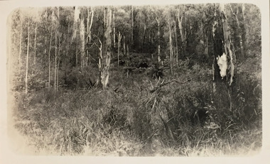
Photograph - Stand of Mountain Ash and tree ferns between Glen Wills and Lightning Creek, c.1925
Henry Beater Christian (1886-1962) , was a descendant of one of the earliest settler families in Kew. Employed at the Kew Asylum as a 'public servant', he was a skilled amateur photographer, photographing numerous scenes in Kew and on his travels around Victoria. The majority of his photographs date from 1916 to 1929. His finest photographs are housed in two photograph albums. Digital copy of a photograph from page 32 of the 47-page photograph album containing 261 gelatinous silver images, loaned by Diane Washfold with permission given to digitise and hold a copy in our collection. John Chapman has written in 'Bushwalking Clubs - A Brief History', about the establishment in Victoria of the first bushwalking club in 1888, and the popularisation of bushwalking during the interwar period. Henry Christian's 'walks' appear to have been undertaken solely or with a companion/s. This black and white photo is part of a group of photos taken in the Victorian High Country. The page is labelled 'Near Glen Wills & Lightning Ridge" and includes photos of bush tracks, family groups, and natural features. The small black and white photo depicts a grove of native mountain ash with a group of tree ferns in the middle distance."NEAR GLEN WILLS & LIGHTNING CRK"henry beater christian (1886-1962), landscape photography, christian-washfold collection, photograph albums, bushwalking, northeast victoria, victorian high country, glen wills, lighting creek -
 City of Kingston
Photograph - Colour, Circa 1993
Edithvale is a suburb in the City of Kingston. It is located between Aspendale and Chelsea on the Port Phillip Bay and built within remnant areas of the Carrum Carrum swamp. The foreshore precinct comprises a wide sandy beach, with low sand dunes and numerous historic boat sheds. The suburb consists of older style dwellings and former holiday houses, combined with mid-century housing and newer homes. The large blocks are increasingly subdivided and the existing dwellings demolished to accommodate units and townhouses, thus changing the landscape of the area and reducing the tree canopy.The beachside suburb of Edithvale was previously part of the extensive Carrum Carrum Swamp. The area was once a source of fish and eels for the Mayone-Bulluk clan of the Bunurong people. Over time the area was drained and predominantly devoted to dairy farming and holiday houses. The farms were gradually sold and subdivided with a large number of homes built after World War II and in the 1960s. Edithvale is mainly residential with a shopping strip along Nepean Highway but little significant industry was ever established in the area apart from a plaster works and confectionary factory, both now closed.Aerial colour photograph of Edithvale as viewed from Alexandra Avenue in the north to Ella Grove Chelsea/Edithvale in the south. The area is built-up with residential housing and facilities including Edithvale Primary School, numerous churches and the Edithvale Railway station. Large sections depict the remnant Carrum Carrum swamp. Edithvale Common and the former "Duck Inn" (Melbourne Water/Friends of Edithvale Seaford Wetlands) can be seen. Edithvale Recreational reserve, the valodrome and Edithvale Public Golf Course are prominent. The image shows vacant land in the area now known as Aspendale Gardens and the newer residential section of Chelsea Heights is not developed. A bike path has been established to cover the secondary drain. The Golf Links Court residential development located off Hughes Avenue is a large vacant block.Yellow circular adhesive sticker on plastic Black ink (marker): * (asterisk) Black type on white adhesive sticker: P000108edithvale, aspendale, chelsea, carrum carrum swamp -
 Eltham District Historical Society Inc
Photograph, The Stokes family home and orchard blanketed with snow, corner Nyora and Eucalyptus roads, Eltham, Winter 1951, 1951
Taken from outside the family home on the southest corner of the intersection of Nyora Road and Pitt Street with Eucalyptus Road. Frank Stokes first traveled to the district by train in 1944 to find land with the intention to establish an orchard. By chance he met Arthur Bird of Bird Orchard (bounded by Pitt Street, Eucalyptus Road and Wattle Grove) and they got talking over their common interest. Arthur put Frank up for the night and pointed out the land, part of Crown Allotment 15, Section 5, Parish of Nillumbik (CA15) somewhat diagonally opposite Bird Orchard. Frank bought the land and for the next two years would travel by train from Melbourne to Eltham every weekend establishing Stokes Orchard and building a home for his family, which they eventually moved into in 1946. Marjorie North remembered well the winter of 1951, when she took children, including son John together with the Shallard and Squire children “in the Austin A40 up the Main Rd., Eltham to farmer Bell’s property alongside the Eltham College. They were able to make a snow man and throw snowballs. (Diamond Valley News, August 5, 1986.p.42) In the mid 1970s the Shire of Eltham divided the orchard up into numerous rate-able parcel lots, which became affordable for Frank. As a consequence Stokes Orchard was turned into a housing development by Macquarie Builders and marketed as the Stokes Orchard Estate in two stages; Stage 1 encompassing Scarlet Ash Court, Ironbark Close and Peppermint Grove bounded by Nyora and Eucalyptus roads c.1976 and Stage 2 encompassing Stokes Place, Orchard Way, The Crest and The Lookout bound by Nyora and Diosma roads c.1979. The development of Orchard Way, The Crest and The Lookout did not proceed as planned due to the lack of the sewer along Diosma Road and so many of the proposed lots were incorporated into five-acre parcels instead.Representative of the orchard growing areas of Eltham. One of the rare times it has snowed in Eltham.Digital file only - Digitised by EDHS from a scrapbook (containing commercially printed photos of digital scans) on loan from Beryl Bradbury (nee Stokes), daughter of Frank Stokes.1951, beryl bradbury (nee stokes) collection, eltham, nyora road, eucalyptus road, snow, stokes family home -
 Ringwood and District Historical Society
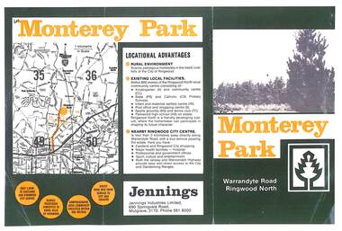
Flyer, Subdivisional Land Sale Brochure, Monterey Park, Warrandyte Road, Ringwood North, Vic. - circa 1980s
Two A4 size gloss paper pages advertising residential development including outline of local facilities and services, with locality map and layout of Monterey Park streets.Monterey Park - Jennings Industries Limited, 690 Springvale Road, Mulgrave, 3170, Phone 5618000. Subdivision includes Parkwood High School, Tortice Drive, Heape Way, Appleberry Place, Stringybark Court, Conifer Court, Crawley Grove, Monterey Close (later Monterey Place), Lucy Place, Middlebrook Drive, Gahnia Close, Glanfield Court, Cone Close, Jull Parade, Pinus Close (later Pinetree Court), Radiata Close, Old Warrandyte Road, and entry from Warrandyte Road. -
 City of Moorabbin Historical Society (Operating the Box Cottage Museum)
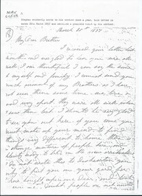
Document, Photocopy Letter Stephen Charman to Michael Charman UK 1857, 1857
Stephen Charman, aged 21years, arrived in Melbourne in 1842 as one of Henry Dendy's Emigrants. 1852 he purchased 160 acres for £328 bounded by Charman Rd and Balcome Rd. 'The Spring' was an important water source for the local Aboriginal people and then for the early settlers. Charman's first wife Harriet and their infant child died and in 1850 he married a widow with 5 children, Mary Gettens. Their first home was made of wattle and daub and they had 7 more children. Later a weatherboard cottage was built c 1855 Together they developed a market garden and specialized in marigolds which were sold for medicinal purposes to the Melbourne Chemists - Martin & Pleasance . The first Methodist Church Services were held at Spring Grove and the Charmans donated land in 1857 for the first Chapel, Cemetery and Primary School . Mary died 1870 and Stephen married again and moved to Gippsland where he died aged 85 in 1906 Stephen and Mary Charman were pioneer market gardeners in Moorabbin Shire 1842 and were involved in the development of Church, school and community in the area now called Cheltenham. Charman Road Cheltenham was a boundary of their land. Letter, handwritten from Stephen Charman to his brother Michael in UK 1857 x 3 pageshandwrittenmoorabbin, cheltenham, dendy henry, dendy's special survey 1841, assisted emigrants, early settlers, pioneers, market gardeners, marigold flowers, pharmacy, charman stephen, gettens mary, charman harriet, methodist church, primitive methodists, box william, box elizabeth, state schools, education, moorabbin shire, moorabbin roads board, city of moorabbin, kingston city council, charman michael, cancel -
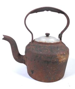 Bendigo Historical Society Inc.
Domestic object - Cast Iron Kettle with non-matching lid
This kettle was made in the 1880s.Cast iron kettle 16 centimetres diameter at its base and 18 centimeters diameter at its widest point 11 centimeters above the base, it then curves up another three centimetres where there is a ten centimetre diameter hole. A non-matching metal lid with a one and a half centimetre knob covers the hole. Three centimetres from the base of the kettle there is a two and a half centimetre diameter spout which tappers to one and a half centimetres, it's 14 centimetres long and has two bends. A handle is attached to the top of the kettle, it is two centimetres wide, it extends two centimetres straight up at both ends that are 12 centimetres apart then forms an open oval 20 centimetres wide and nine centimetres high, it's one and a half centimetres thick for 11 centimetres at the top and has groves for fingers on the under edge.K23.1kettle, cast iron -
Kew Historical Society Inc
Archive (Sub-series) - Subject File, Baptist Church, 1958
Various partiesReference, Research, InformationKHS OrderSubject file including a number of original and reproduced primary sources relating to the Kew Baptist Church in Highbury Grove, and the East Kew Baptist Church in Woodlands Avenue. These include ‘Kew Baptist: Young People’s Society of Christian Endeavour - Golden Jubilee 1890 to 1940’ [bound photocopy], ‘Kew Baptist Church: The Achievements and Progress during 75 years’ [bound photocopy], ‘Kew Baptist Church History 1856-1906’ [bound photocopy], ‘Kew Baptist Church: A Record of 75 Years 1856-1931’ [1st edition], and ‘Tested Recipes: Compiled by the Members of the East Kew Baptist Ladies Guild’ [original copy donated by Christine Pitt, Nunawading, 2013). In addition to these publications, three of which were donated in 1982 by Rev and Mrs Manton, the file contains research notes on Ministers (2015) and a letter relating to Church records.kew baptist church, churches - kew (vic.), highbury grove - kew (vic.)kew baptist church, churches - kew (vic.), highbury grove - kew (vic.) -
City of Kingston
Photograph - Colour, 6 March 1993
Edithvale is a suburb in the City of Kingston. It is located between Aspendale and Chelsea on the Port Phillip Bay and built within remnant areas of the Carrum Carrum swamp. The foreshore precinct comprises a wide sandy beach, with low sand dunes and numerous historic boat sheds. The suburb consists of older style dwellings and former holiday houses, combined with mid-century housing and newer homes. The large blocks are increasingly subdivided and the existing dwellings demolished to accommodate units and townhouses, thus changing the landscape of the area and reducing the tree canopy.The beachside suburb of Edithvale was previously part of the extensive Carrum Carrum Swamp. The area was once a source of fish and eels for the Mayone-Bulluk clan of the Bunurong people. Over time the area was drained and predominantly devoted to dairy farming and holiday houses. The farms were gradually sold and subdivided with a large number of homes built after World War II and in the 1960s. Edithvale is mainly residential with a shopping strip along Nepean Highway but little significant industry was ever established in the area apart from a plaster works and confectionary factory, both now closed.Laminated aerial colour photograph of Edithvale as viewed from Alexandra Avenue in the north to Ella Grove Chelsea/Edithvale in the south. regents Park Aspendale can be seen in the top left. The area is built-up with residential housing and facilities including Edithvale Primary School, numerous churches and the Edithvale Railway station. Large sections depict the remnant Carrum Carrum swamp. Edithvale Common and the former "Duck Inn" (Melbourne Water/Friends of Edithvale Seaford Wetlands) can be seen. Edithvale Recreational reserve, the valodrome and Edithvale Public Golf Course are prominent. The image shows vacant land in the area now known as Aspendale Gardens and the newer residential section of Chelsea Heights is not developed. A bike path has been established to cover the secondary drain. The Golf Links Court residential development located off Hughes Avenue is a large vacant block.Black type on white adhesive label: 6-3-93 Black type on white adhesive label: 25/9211, 6/3/93, 11.20 am Black type on white adhesive label: 9211 Yellow circular adhesive sticker Black pencil: 9211 6-3-93 arrow pointing Nedthvale, carrum carrum swamp, aspendale, chelsea -
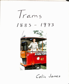 Melbourne Tram Museum
Album - Photo Album, Colin Jones, "Trams 1883 - 1993", 1990's
Photo Album, grey decorative front cover with a grey heavy card slip case, 30 leaves of heavy paper, each separated by a semi clear protective sheet. Compiled by Colin Jones with a title sheet "Trams 1883 - 1993" with Colin standing in the front of Brisbane Tramway Co. No. 47 at the Ferny Grove Museum. Bound with end papers. Photos retained by clear photo corners. Features photos by Colin of: Victor Harbor Surabaya Indonesia Melbourne cable trams, Sydney Steam tram in the UK Ballarat Bangkok Semarang Indonesia Adelaide Brisbane Melbourne Sydney Bendigo Launceston Osaka Japan Perth Kyoto Dalian Japan Fukuoka Japan Kanazawa Japan Hong Kong Sendai Kita Kyushu Hobart Lopburi Kobe Hiroshima Tokyo Matsuyama Japan Nagaski Various Museums in Australia. Sample pages only scanned.trams, tramways, melbourne, album, japan, indonesia, australian tramways -
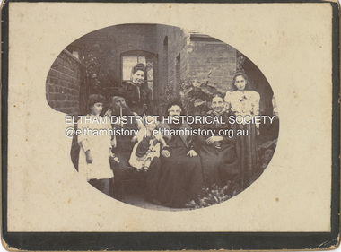 Eltham District Historical Society Inc
Photograph - Cabinet Photograph, William Ingram family, Birmingham, England, c.1880
William Ingram with possibly his wife Pamela Thomas and family members. William is second from left with pipe, the others unidentified. The family lived in Birmgham, England. William, a baker died in 1905. William and Pamela had six children; William George Grove (1861-1939), Elizabeth (1865), Evan Thomas (1867-1956), Joseph (1868-1934), Louis (1870-1941) and John (1872-1958). John Ingram learnt his trade from his father but following a quarrel with his father, he ran away and worked his passage to Australia as a ships baker. His elder brother Evan was already in Australia living in Malvern. It was here that he met Ada Key. John and Ada were married in Fremantle, Western Australia. They travelled to England then Cape Town, a family already started. They returned to Melbourne and in 1901 bought land at Research where he worked to establish an orchard and worked at night asa baker in Eltham. The fashion and hairstyles appear trypical of around 1880ingram family, birmingham, william ingram, baker, pam thoonen (nee ingram) collection -
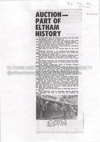 Eltham District Historical Society Inc
Document - Property Binder, 816 Main Road, Eltham
Newspaper article: Auction part of Eltham History, Diamond Valley News, 11 March 1980, auction on 15 March of The Hawthorns and other properties by the Burgoyne family. On same page another article :"The unusual on a hill" about Robert Marshall, Shire Councillor and architect's own home. On reverse side real estate advertising including several Woodridge Estate properties. Newspaper article: Centre becomes a second home, Diamond Valley News, Tuesday, September 23, 1986, p3 about new child minding centre. On same page "residents carry on fight for road works" about planned road works in Kirwana Grove, Montmorency and "Advice bureau needs volunteers" about Eltham Citizens Advice Bureau. On reverse side (page 4) advertising for Kentons Shoes closing down sale at Shop 3 Eltham Mall, Arthur Street and article "Nursing mums donate books" featuring Eltham Branch of Nursing Mothers Association (with photo).main road, eltham, property, the hawthorns house, burgoyne family, harry burgoyne, hawthorn hedges, 816 main road eltham, advertising, avril benson, child minding centre, eltham citizens advice bureau, eltham high school, eltham rsl sub-branch, eltham shire council, john stevens, kaye mount, kirwana grove, main road child minding centre, montmorency, montmorency primary school, roadworks, rob stanley, ruth kirkpatrick, angela hennel, arthur street mall, banner project, diamond valley childbirth education association, kentons shoes, nursing mothers association, sue gavan, woodridge estate, mudbrick, robert marshall, st andrews -
 Bendigo Military Museum
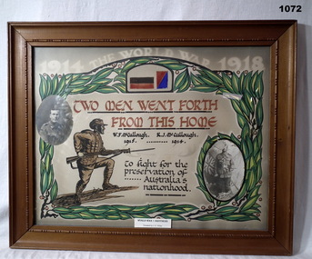
Certificate - CERTIFICATE, FRAMED, Post 1920
Reginald Joseph McCULLOUGH No 2203 enlisted in the AIF in 15th reinforcements 3rd LHRegt on 15.11.1915 age 28 years 7 months. Embarked for Egypt 16.3.1916, transfers to Artillery Details 15.5.1916, embark for England 28.6.1916, attached to 5th Div Artillery, embark for France 4.9.1916, transfer to 14th FAB 11.10.1917, WIA 2.11.1917, SW to right leg fracture, rejoin unit 19.7.1918, hospital 25.10.1918 with Cellulitis left knee then classified as Synovitis, transfer to AHQ 9.12.1918, hospital 20.12.1919, died Grove Military hospital England classed as Excema and Syncope 30.12.1919. William Francis McCULLOUGH No 2863 enlisted in the AIF in 6th reinforcements 24th Battalion on 12.7.1915 age 21 years. Embark for Egypt 27.10.1915, transfer to 7th Bn 24.2.1916, embark for France 26.3.1916, hospital 18.6.1916 Dental, rejoin unit 25.6.1916, hospital 4.11.1916 with Diarrehoea, rejoin unit 9.11.1916, hospital 22.4.1917 (unclear) rejoin unit 13.5.1917, transfer to 1st Aust Div Signals, discharged from the AIF 28.7.1919.WWI Brothers - W F McCullough & R J McCullough. Frame, tan wooden, glass front, cardboard backing. Certificate, painted, coloured with a photo of each brother inserted.On certificate: TWO MEN WENT FORTH FROM THIS HOME W F McCullough 1915 R J McCullough 1914 On sticker at bottom of glass: WORLD WAR I BROTHERS Donated by J E Wilesdocuments - certificates, frame accessories -
 Old Colonists' Association of Ballarat Inc.
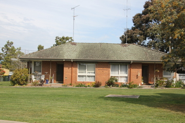
Image, Ballarat Old Colonists' Association Retirement Village - Joe White Homes, 23/09/2017
These homes were built in 1969. One of the first objectives of the Association was "to provide the shelter of a those for those Pioneers of the Goldfields whom the reverses of fortune have deprived of the means of procuring the comforts of life in their declining years." The first home at Charles Anderson Grove was built in 1925. Before that time the Association provided relief for needy pioneers. relief included monthly monetary payments, loads of firewood, medical assistance and distribution of Christmas bosed of groceries to deserving pensioners, and in some cases payment of burial costs. ::a) The dominant purpose of the Association is to give public benevolent relief as a charity, but providing independent living accommodation in our Retirement Village for person in need who are over 65. ::b) To raise funds by membership subscription, commercial and residential rents, donations, gifts and voluntary work, for the purpose of providing direct relief of poverty, distress, misfortune or helplessness. ::c) To maintain the important heritage and ongoing viability of the Old Colonists' Association. (Revised Rules of the Old Colonists' Association of Ballarat Inc., 2016) The Joe White Cottage in the Ballarat Old Colonists' Association Retirement Village.old colonists' association, ballarat, ballarat old colonists' club, joe white, charles anderson grove, joe white cottage -
 Old Colonists' Association of Ballarat Inc.
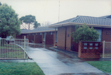
Image, Ballarat Old Colonists' Association Residence - Unit 1-6 Ascot Street, Ballarat, c2000
These units were built in 1991. One of the first objectives of the Association was "to provide the shelter of a hose for those Pioneers of the Goldfields whom the reverses of fortune have deprived of the means of procuring the comforts of life in their declining years." The first home at Charles Anderson Grove was built in 1925. Before that time the Association provided relief for needy pioneers. relief included monthly monetary payments, loads of firewood, medical assistance and distribution of Christmas bosed of groceries to deserving pensioners, and in some cases payment of burial costs. ::a) The dominant purpose of the Association is to give public benevolent relief as a charity, but providing independent living accommodation in our Retirement Village for person in need who are over 65. ::b) To raise funds by membership subscription, commercial and residential rents, donations, gifts and voluntary work, for the purpose of providing direct relief of poverty, distress, misfortune or helplessness. ::c) To maintain the important heritage and ongoing viability of the Old Colonists' Association. (Revised Rules of the Old Colonists' Association of Ballarat Inc., 2016) Colour photograph of the former Old Colonists' Association of Ballarat Inc homes in Ascot Street, Ballarat.ballarat old colonists' association, homes, ascot street units -
 Kew Historical Society Inc
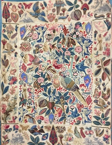
Decorative object - Cotton chintz applique on linen wall hanging [Broderie Perse], 19th Century
This broderie perse' wall hanging was donated to the Kew Historical Society in 1980 by Mrs Joy Ivory. The hanging had belonged to her mother - Amy Grigg - and was used by the latter to demonstrate skills in darning (the red stitching). Provenance includes a certificate dating from 1889 which records an award to Amy Grigg of Pakington Street (Kew) for skills in needlework, issued by the Kew Floral Industrial & Art Society. Amy Grigg later married Albert Watson, the son of John Watson. The latter was an early pastor of the Kew Methodist Church in Highbury Grove, Kew. Both the Watson and Grigg families were early pioneers of Kew. While the hanging was modified by Amy Grigg in 1889, the original textile dates from an earlier period when 'Broderie Perse' (Persian embroidery) was used to create quilts and wall hangings. It is estimated that the hanging dates from the first half of the 19th century. An exact dating will require a detailed examination of the cotton chintz fabrics used to embroider the hanging. This appliquéd wall hanging is one of the earliest textiles in the Kew Historical Society's fashion & textiles collection. Similar examples are held in major international collections such as the Victoria & Albert Museum. This example of broderie perse is significant for the cross-cultural influence of Indian textiles on European taste, not unusual given the English foothold in India during this period. Additional interest is due to the mixing of Indian and European textiles in the design, while staying true to the derivation of the design. The textile is both well-provenanced and rare. While it is unlikely to be Australian-made, it is probably an example of a textile brought to Australia during the colonial period that indicates a desire to decorate interiors using items created in and for the English home. On another level, the wall hanging is a fine example of 'women's work' in the first half of the nineteenth century.Small wall hanging, comprised of five panels that are each appliquéd by hand in herringbone stitch using a range of decorative figurative motifs including flora and fauna. The design is based on an Indian palimpore representing a tree of life design. The base textile is a cream linen while the appliquéd figures or shapes are cut from cotton chintz. These additions are probably a mix of Indian and European designs. The quality of the herringbone stitching is very fine. Later stitching in red wool was added in the 1890s to demonstrate skill in darning. The main panel is bordered by a narrow green and ecru braid. It has a narrow tan braid at the top and bottom of the two side panels. A surrounding tan braid around the entire textile is missing in some places. textiles, applique, broderie perse, amy grigg, wall hangings, migration -
 Kew Historical Society Inc
Album - Scrapbook, Eva Grant, Historic Buildings, Kew, 1958-78, 1970s
One of three scrapbooks of photographs and newspaper cuttings taken and or collected by Eva Grant, a past member of the Kew Historical Society, which were donated by her niece, Julie Thomson. The albums include many photographs of Kew from the 1950s to the 1970s. Buildings included in the scrapbook include: Billy Hughes' house - 167 Cotham Road Congregational Church - Walpole Street (c.1978) Country Roads Board - Denmark Street (1960) Dorothy Rogers Reserve - Studley Park Road Ellsmere (also Ellesmere/Ellsmore) - Princess Street Field Place - 3 Henty Court Fernhurst - 13 Fernhurst Grove Kew Civic Centre (1959) Kew Junction (1958) Kew Railway Station (1902, 1959) Kew Recreation Hall - Wellington Street (1960) Neama (Hall) - Studley Park Road Southesk (formerly Ordsall) - Cotham Road (c.1960) St Anthony's Home for Babies (formerly Madford) - 43 Wellington Street (c.1976) Studley House - Nolan AvenueThe scrapbook contains historically significant, rare and sometimes unique images of significant heritage buildings in Kew, including their erection and demolition. 11-page scrapbook of photographs and newspaper clippings with annotations by Eva Grant, a past member of the Kew Historical Society. The pages of the album can be viewed in the image carousel above. Based on the text and known dates of demolition of a number of the buildings, the scrapbook was assembled over a twenty year period between c.1958-c.1978.Includes letter from donoreva grant, billy hughes' house - 167 cotham road, congregational church - walpole street - kew, country roads board - denmark street - kew, dorothy rogers reserve - studley park road - kew, field place - 3 henty court - kew (vic), ellsmere (also ellesmere/ellsmore) - princess street - kew, fernhurst - 13 fernhurst grove - kew (vic), kew civic centre - civic drive - kew (vic), kew junction - kew (vic), kew railway station - denmark street - kew (vic), recreation hall - wellington street - kew, neama - hall - studley park road - kew (vic), southesk - ordsall - cotham road- kew (vic), st anthony's home for babies - madford - 43 wellington street (vic), studley house - nolan avenue - kew (vic) -
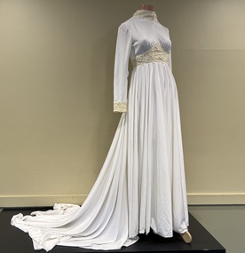 Kew Historical Society Inc
Clothing - Wedding dress, The House of Franke, Stuart, c.1975
At 5pm on 2 May 1975 at Christ Church, Hawthorn, the wedding took place between Kathryn Gwynn Marx of Mason Street, Hawthorn, and William Peter Reeve of Mountain Grove, Kew. The bride's dress was purchased from the 'House of Franke, Stuart', 612 Glenferrie Road, Hawthorn, a very popular place in the 1970s for brides. Kathryn was educated at Ruyton Girls' School with Margaret Franke so it was a nice connection. Margaret's family business had been in operation since 1926. I loved my wedding dress. It was soft and comfortable to wear and kept me warm on the May evening. It was elegant and I knew I would never get the chance to wear something with a long train again. Walking down the staircase at the Windsor Hotel in Melbourne felt very grand; a memory I still hold today. (Kate Reeve, 2022) [Note: Two photos and a newspaper article which are viewable in the image carousel are held in the donation file]Strong local provenance to Hawthorn, Kew and Boroondara due to owner and retailer. It is a representative example of wedding dresses sold in the 1970s. The wedding dress is made of fine soft white jersey with guipure lace around the neckline, wrists and bodice. The long train has three small discreet loops along the hemline which can be slipped onto a finger for a draped effect giving ease of movement for dancing etc. A satin trimmed veil covered the length of the train and was secured on the head with a satin coronet. White leather shoes were worn. The bouquet Phalaenopsis orchids. (Note: the veil and shoes were not part of the donation)Label: Franke Stuart / Hawthornfashion & design - 1970s, wedding dresses, kate reeve, peter reeve, franke stuart, retailers - glenferrie road - hawthorn (vic.) -
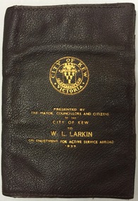 Kew Historical Society Inc
Functional object - Presentation Wallet, City of Kew, 1939, 1939
William 'Bill' Leo Larkin (b. 19.09.1898) was born in Hawthorn (Vic). [His World War I enlistment papers give details of the Hawthorn birthdate, as well as Ballarat, but his birth records state his birth as Hawthorn). After leaving St Patrick's College in Ballarat in 1917, he enlisted in the army serving in England and France. At the time of his enlistment in the army in the Second World War (17 April 1940), he was recorded as living in Kew. His service number was VX11459. The Sands & McDougall Directory of 1938 gives his address as 31 Fernhurst Grove. In the army he served in the Middle East and in New Guinea. He was to attain the rank of Lieutenant Colonel in 1942. He was made an Officer of the Order of the British Empire (O.B.E) in 1946. Enlistment Presentation Wallets were presented by the City of Kew from 1940 to men who enlisted in the war. Typically, these wallets are dated 1939, even though the enlistment may have occurred at a later date.Memento presented to citizens of Kew (vic.) on enlistmentRectangular brown leather single fold wallet with eight internal pockets. The front includes an embossed City of Kew logo and the words ‘Presented by the Mayor, Councillors and Citizens of the City of Kew to W. L. Larkin on Enlistment for Active Service Abroad, 1939'.second world war 1939-1945, world war two, city of kew, william leo larkin, bill larkin, presentation wallets -
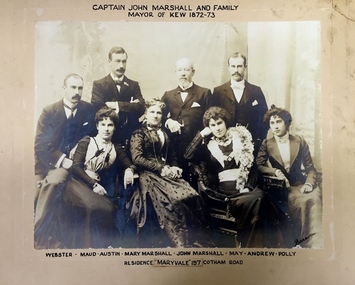 Kew Historical Society Inc
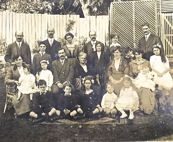
Photograph - Family Portrait, Captain John Marshall and Family, Mayor of Kew 1872-73, 1890s
Captain John Marshall was born in Dundee, Scotland c.1833. Within eleven years of his arrival in Melbourne in 1852, he had established an important colonial shipping company, Anderson & Marshall, and married Mary Austin, the eldest daughter of Thomas Austin Esq of Clifton Villa in Cotham Road. Elected to the Kew Borough Council in 1869, he remained an active member until 1875. During this period, he was elected Mayor of Kew in 1872. A Scottish Protestant by birth and conviction, John Marshall was, with David Beath, a member of the inaugural committee that began planning for a separate Presbyterian Church in Kew, lending the Committee the funds to purchase land on the corner of Cotham Road and Highbury Grove. John Marshall lived at his home, 'Maryfield', at what was then 239 [now 197] Cotham Road until shortly before his death at the age of 70 in January 1903. He was buried on 14 January in Grave 493, Presbyterian Compartment A, Boroondara General Cemetery.Family portrait of an important civic figure in Kew in the 19th century who was also a notable businessman and shipowner in the Colony of Victoria.Albumen Silver photograph on card of Captain John Marshall and family, Mayor of Kew 1872-73.The inscription was added by the family and at one stage modified. In addition to the title, the sitters' names are inscribed beneath the photograph on the mountCaptain John Marshall and family / Mayor of Kew 1872-73 Webster - Maud - Austin - Mary Marshall - John Marshall - May - Andrew - Polly / Residence “Maryvale” 197 Cotham Road. john marshall, maryvale (cotham road, kew), maryfield (cotham road, kew), webster marshall, maud marshall, austin marshall, mary marshall, may marshall, andrew marshall, polly marshall -
 Kew Historical Society Inc
Photograph - Family portrait, The Marshall Family, 1903-1914
Captain John Marshall was born in Dundee, Scotland c.1833. Within eleven years of his arrival in Melbourne in 1852, he had established an important colonial shipping company, Anderson & Marshall, and married Mary Austin, the eldest daughter of Thomas Austin Esq of Clifton Villa in Cotham Road. Elected to the Kew Borough Council in 1869, he remained an active member until 1875. During this period, he was elected Mayor of Kew in 1872. A Scottish Protestant by birth and conviction, John Marshall was, with David Beath, a member of the inaugural committee that began planning for a separate Presbyterian Church in Kew, lending the Committee the funds to purchase land on the corner of Cotham Road and Highbury Grove. John Marshall lived at his home, 'Maryfield', at what was then 239 [now 197] Cotham Road until shortly before his death at the age of 70 in January 1903. He was buried on 14 January in Grave 493, Presbyterian Compartment A, Boroondara General Cemetery.Family portrait of the relatives of an important civic figure in Kew in the 19th century who was also a notable businessman and shipowner in the Colony of Victoria.Albumen silver photograph on card of the Marshall family grouped in three rows in a garden setting. The twenty-three members of the extended family do not include John Marshall so the photograph presumably dates from after his death in 1903. His wife, Mary Marshall, is in the middle row, five from left. marshall family, john marshall -- mayor of kew -
 Ringwood and District Historical Society
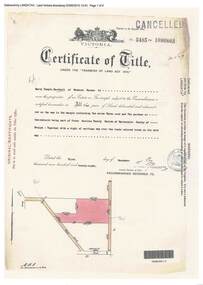
Document, Certificate of Title - Harry Temple Marshall, Wesburn Farmer, Vic. - part of Crown Section 20, Parish of Warrandyte, County of Evelyn - 1928
A4 copies of Landata Victoria Historical Search documents - Vol 5485 Fol 1096803. Harry Temple Marshall is now the proprietor of an Estate in Fee-simple subject to the Encumbrances notified hereunder ... 10 acres 3 roods 10 perches or thereabouts, together with a right of carriage way over roads coloured brown. Subdivision map includes un-named roads - western side is Wonga Road (later Warranwood Road), and eastern side is Grandview Grove (later Bemboka Road), both north of Plymouth Road, Ringwood, Vic. Transfers include Harold Claude Howship, 1st December, 1928 James Bell McAlpin, 26th March, 1939. -
 Victoria Police Museum
Police Stations (Armadale)
Armadale is an inner suburb of Melbourne, Victoria, Australia, 7 km south-east of Melbourne's Central Business District, located within the City of Stonnington local government area. Armadale Police Station opened, in Melbourne Police District, on 11 May 1885. Its original location is unknown, but in 1890 it is listed in the Sands & McDougall directory as at 295 Hight Street. From 1985-1920 it was located at 20/22 Auburn Grove, 1925-1930 at 769 High Street and 1935-1946 at 3 Cheel Street. The station closed on 28 January 1946. The sub-division east of Orrong Rd was incorporated into Malvern Sub-district and west of Orrong Road into Prahran Sub-district. In a special 1930 issue of the Victoria Police Gazette the Armadale Police Station was described as a seven-roomed brick dwelling with a tiled roof on land measuring 127' x 104' x 98'. There was also a bathroom and W.C., a wash-house, office, and a lock-up (one cell). This is probably a description of the Cheel Street police station. It was staffed by one senior constable and three foot constables.12 photographs comprising 8 coloured images and 4 black and white images 1 sketch plan of Old Armadale Police Stationpolice stations; armadale police station -
 Melton City Libraries
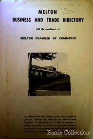
Booklet, Melton Business and Trade Directory, c.1965
BUSINESS TRADE AND DIRECTORY MAP NORTH of High Street RALIEGHS Road - Early settlers Oliver Reierson ( Norwegian) Raliegh SHEBLER Court Auguste EMIL Court Jongebloed Family residence “Hemlich” ALEXANDRA Street Coronation King, Queen Alexandra - 1903 O’NEILS Road Farmer OLDERSHAW Road CORR Grove Early landowner, Teacher at the Common School – Denominational Churches, 1850’s Wesleyan (Methodist) BRYAN Court 1850’s resident renamed from earliest town site - Flat HURLEY Street Early settler and farmers - CHESNEY Road was named Minns, due to duplication altered to Chesney (Minns) SOUTH of High ALKEMADE Drive. Family name ARNOLD Court Family BARRIES Road Charles Ernest Barrie “Darlingsford” 1911 Residence KILPATRICKS Road became Barries Road west of Station Road BLACKWOOD Drive Alexander, Early settler CALLANAN Drive Surveyor early LUBY Court John Luby - Crown Grant Land title KERWIN Street Michael - Crown Grant land title (deleted due to Freeway)Pamphlet of Melton Businesses and map of the townlocal identities, misc., council