Showing 33937 items
matching building-fittings
-
 Bendigo Historical Society Inc.
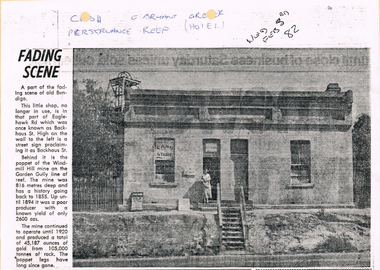
Newspaper - LONG GULLY HISTORY GROUP COLLECTION: E BRYANT - GROCER
BHS CollectionCopy of a newspaper article titled Fading Scene. Photo shows a building with a stairway leading down to the road in front of it and a lady standing in the doorway. One window has Cash Store printed on it and there are two placards leaning on the building to the left of the lady. Each side of the building are shrubs and picket fence. In the background to the left is the poppet of the Windmill Hill Mine on the Garden Gully line of reef. It is in that part of Eaglehawk Rd which was once known as Backhaus St. High on the wall to the left is a street sign proclaiming it as Backhaus St. Written above the photo is C-sh, E Bryant, Gro-er (there are holes through the words), Perseverance Reef (Hotel). Wed Feb 3rd 82. Article is mounted on yellow card which is mounted on purple card and laminated.bendigo, history, long gully history group, the long gully history group - e bryant - grocer, windmill hill mine, garden gully line of reef, e bryant, perservance reef (hotel) -
 Greensborough Historical Society
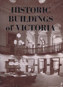
Book, Historic Buildings of Victoria, 1966_
A listing of National Trust listed buildings from around Victoria in 1966. Each entry has a photograph and caption with some history of the building. Arranged by region.The development of architectural style in Victoria.278 pages, black and white illustrations. Hard cover. Dust jacket has illustration of interior of the Library of the Supreme Courtmelbourne architecture, victoria architecture, historic buildings victoria, national trust of australia, victoria -
 Bendigo Historical Society Inc.
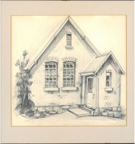
Drawing - Epsom Primary School
Initially serviced by a weatherboard building as school No. 221, the brick building was opened by the Minister of Education in February 1881. It was renumbered No. 2367 and built to accommodate 130 children.Pencil sketch of the Epsom primary school no. 2367 it shows the front of the school with a tree to the left. Signed by the author David Tunley. David was a music teacher at Epsom in the 1980's.On the back: drawing by David Tunley early 1980's. 24/04/2004 Dear Jayne and Anna (Sutherland) it was in this little school that you displayed so much flair, potential and artistic ability. Much love David.epsom, epsom primary school, drawing -
 St Kilda Historical Society
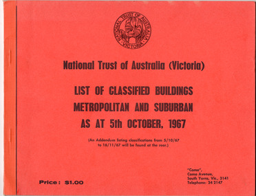
Booklet - List of Classified Buildings, National Trust of Australia (Victoria), List of Classified Buildings Metropolitan and Suburban, 1967
National Trust of Victoria List of Classified Buildings, Metropolitan and Suburban, as at 5th October 1967. Includes more than 20 significant buildings in St Kilda30 page booklet with orange coverwh greaves collection, greaves, city of st kilda, st kilda council, historic buildings, national trust -
 Flagstaff Hill Maritime Museum and Village
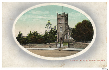
Postcard - Historical, Warrnambool, Christ Church, Warrnambool, Early 20th century
The nine postcards in this set were donated together and date to the early 1900s. All but one postcard in this set shows images of Warrnambool, in the Western District of Victoria; the other has a London image. The postcards were all printed in Great Britain according to that country’s postal regulations. The fronts of all cards have titles printed in red. Most of the images on the cards are attributed to photographer Joseph Jordan and belong to the Jordan Series. The back of these cards has an outline for a postage stamp, a vertical dividing line and a heading on each side of the line to separate the Correspondence from the Address. Postcards or ‘correspondence cards’ appeared in Britain in 1894. They were plain cards with a space for the message on one side and an address on the other; regulations didn’t allow anything but the address to be written on the ‘address’ side. In 1902 the British regulations then allowed a picture to be printed on the front and the address on the back, so messages had to be written on the picture side. Soon, the regulations changed and the back was divided for a message and the address. Christ Church Warrnambool – The image on this card shows Christ Church, a stone building built in 1856. The Anglican church is in Henna Street, Warrnambool. The church, outer buildings and grounds are heritage-listed. Its bell tower harbours German bells. Joseph Jordan - Joseph Jordan was born in 1841 in Leicester England. When he was 16 he joined the 7th Queen's Own Hussars and was sent to India at the outbreak of the mutiny. He took part in the relief of Lucknow and remained in India for eleven years. It was during this time, he became interested in photography. He was posted to New Zealand and later came to Victoria, becoming a sergeant major of the Mounted Rifles. In the mid-1880s he came to the Western district where he was responsible for establishing units of the Mounted Rifles in various country towns such as Dunkeld, Mortlake, Panmure, Bushfield, Koroit etc. He resigned from the army in 1889 and set up a professional photography studio in Liebig Street, Warrnambool. He became very well known in the Western District for family photographs, official photographs of local councillors and groups as well as views of local scenery. In 1891 he photographed the wrecked barque ‘Fiji’ at ‘Wrecks Beach’ near Princetown. His business was taken over by his son Arthur around 1917. Joseph was a keen rifle shot and in 1924 he donated the "Jordan Shield" as a prize to the Victorian Rifle Association. He was made a "Life Honorary Member" of the Warrnambool Returned Soldiers League and in 1933 he was recognised as being the oldest living soldier in Victoria. Joseph died in 1935 aged 95.This card is the only one of the nine cards with the location of Warrnambool added to the name 'Joseph Series'. It is also the only one that has text within the outline for the postage stamp. The font used for the test of the headings is slightly different to the other cards. Joseph Jordan is a significant figure in Warrnambool history as he helped to establish early units of the Mounted Rifles (G Company) in local towns during the late 1880's and later, photographed local scenes, groups and citizens of early Warrnambool. This postcard of Christ Church Warrnambool is significant for its connection to the church. The early building of the church in 1856, within the first decade of Warrnambool being proclaimed a town, shows the strong religious desire of the community. The church is part of Warrnambool's life events and the historical significance of the building,Postcard, one of nine, landscape orientation, coloured print within an oval border and mauve-toned shading. The cameo image is a stone castle-top bell tower beside a church building flanked by trees. A stone fence is across the front, with pedestrian and vehicle white picket gates. The title is in red print on the front of the card. There is no correspondence written on the card. The reverse has inscriptions and outlines for a postage stamp. Jordan Series, printed in Great Britain.Front, in red: “CHRIST CHURCH, WARRNAMBOOL” Back in black: “Jordan Series” “POST CARD” “PRINTED IN GREAT BRITAIN” “For correspondence” “The Address only to be written here”flagstaff hill maritime museum, flagstaff hill maritime village, flagstaff hill maritime museum and village, maritime museum, warrnambool, great ocean road, warrnambool and district, warrnambool scenes, local scenes, views of warrnambool, joseph jordan, jordan series, jordan photography, postcard, souvenir, correspondence, cameo postcard, landscape, christ church, bell tower, german bells, warrnambool church, religious building, stone building, anglican church, parish of warrnambool -
 Flagstaff Hill Maritime Museum and Village
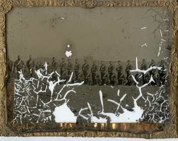
Photograph - Glass plate, circa 1866
This glass plate photograph shows good detail of members of the Warrnambool Garrison posing for their photograph in front of a young township. There are other well-dressed citizens behind them. The three men with frogging on their sleeves were commanders were likely to be commanders. The men are facing north with Cannon Hill and the fortification area in the background. It dates from the 1860s. The firearms held appear to be 1853 pattern Lee Enfield muskets used by the British army in Crimea at this time and in Australia, rather than the later Martini Henry cartridge rifles. The uniforms match other photos of the Warrnambool Garrison Militia and Band in our Collection, taken up until the 1880s. The three storey building in the photograph is likely to be the Manifold & Bostock flour mill, built in 1854 near the ‘cutting’ in Merri Street, which was one of the main streets at the time; if one faced the building’s front from a vantage point and looked south to south-east, the hills around Flagstaff Hill and Cannon Hill would be behind that mill, and the Harbour behind the hills. This is the area of the Fortifications. The glass plate method of photography was widely used during the mid-19th to early-20th century. The donor and maker of the photograph are unknown. Around this time the citizens of Victoria were prospering from the gold rush but felt isolated and uneasy about their security in the colony. In 1854 the Volunteer Act was passed to provide some military defence. In 1858 the Warrnambool Volunteer Rifle Corps was established, disbanded in 1863, then a new Warrnambool Detachment was formed in September 1866. Legislation was passed in 1884 that replaced the volunteers’ corps with a partly paid, permanent Militia Defence Force. The batteries manning the coastal forts of Victoria were termed Garrison Artillery Companies. When the Army was federated in 1901 there were eight Militia Companies in Victoria. Warrnambool and Port Fairy together were known as 8 Coy AGA (Australian Garrison Artillery). Changes to formation and name continued into the 20th century.This photograph is a record of the very early local defence force, circa 1866. The photograph signifies the connection of the colony in Victoria to the growing need for security due to the unrest in Europe at that time. The photograph is also locally significant to the industry of the young township of Warrnambool, showing what is likely to be one of the first flour mills in the town. The photograph is also the only example of the early methods of glass plate photography in our collection. Photograph, rectangular glass plate, positive sepia image. Photograph has brass framed edges that fold over to the back, with mitred corners. The front edges are pressed with a decorative floral pattern. The photograph shows a group of thirty military men, standing or kneeling, in dark uniforms with pillbox forage caps, round-collared jackets with light buttons, light sashes worn from top left shoulder to bottom right side of waist belt, and long, straight-legged trousers. Three of these men have light braid around the buttons on the front of their jackets, light frogging on their sleeve cuffs and stripes on the outside seams of their trousers. The other twenty-seven men have plain uniforms and are holding firearms in their right hands, steadied with their left hands. Other figures are standing behind this group of soldiers, including three or four men wearing top hats, jackets and ties. In the background is a row of buildings. The central building is three stories high. Bare hills are in the far background. The foreground is uneven ground with patches of short grass. Photographer looking towards the south east and Cannon Hill, with the Warrnambool Garrison facing north, ca.1860s.flagstaff hill, warrnambool, shipwrecked coast, flagstaff hill maritime museum, maritime museum, shipwreck coast, flagstaff hill maritime village, great ocean road, glass plate, photography 19th century, colonial forces, military defence, volunteer act 1854, volunteer rifle, garrison artillery, volunteer corps, militia, militia garrison band, pillbox forage caps, helpmann, manifold and bostock, 1853 lee enfield musket, tintype, warrnambool garrison, 1860s, cannon hill, manifold & bostock, flour mill, 3-storey building -
 Ballarat Heritage Services
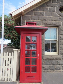
Photograph - Photograph - Colour, Clare Gervasoni, Koroit Post Office, 2015, 21/12/2015
The town borrows its name from the Koroitch Gundidj people who occupied the area prior to European settlement. (https://en.wikipedia.org/wiki/Koroit, accessed 21 December 2016) Koroit was first surveyed as a township in 1847. Around the 1850 the district had the highest population of Irish immigrants in rural Australia. The Koroit Post Office was designed by architect and engineer John Mason of Port Fairy. (Moyne Shire Heritage Study 2006 Stage 2, Volume 2: Environmental History, Prepared for Moyne Shire Council Helen Doyle in association with Context Pty Ltd, 2006.) Rosebrook Bridge, Rosebrook (1853; replaced) Post Office buildings, Bank Street, Port Fairy (c.1857) The author Henry Handel Richardson lived in the Koroit Post Office as a child after her family moved to Koroit in 1878. Remembering Koroit from her youth, the third volume in her The Fortunes of Richard Mahony trilogy is set in the town. When the author was six, her father Walter died in Koroit on 1 August 1879 and was buried at the Koroit cemetery. (https://en.wikipedia.org/wiki/Koroit, accessed 21 December 2016) In 1878 Mary Richardson was appointed postmistress of the Koroit Post Office at a salary of 72 pounds with free quarters, firewood and kerosene. She lived at the back of the Post Office. (From a Green and Pleasant Land by H. McCorkell and P. Yule.) Photographs showing the bluestone Koroit Post Office, phone box and postbox. It is located at 99 Commercial Road, Koroit. "Historic Area Statement of Significance: The significance of Koroit derives from its role as the urban centre of one of the most concentrated Irish Roman Catholic rural districts in Australia, noted for its mixed livestock and cropping argicultural patterns. This is reflected in two separate and distinctive areas in the town - the administrative/commercial area and the church precinct. The administrative and commercial area (focussing on the Boundary-Commercial Road/High Street intersection and the Koroit Hotel) consists of a number of significant public buildings and leads to a street of relatively intact humble shopfronts and kerbline verandahs, visually punctuated by opposing bank facades. The church precinct is dominated by a group of Catholic buildings larger in scale and more complete in range than those in any comparably sized Victorian town." http://vhd.heritagecouncil.vic.gov.au/places/69338#sthash.ELLuSMvg.dpuf, accessed 21 December 2016."koroit, post office, phone box, payphone, bluestone, henry handel richardson, koroit post office -
 The Beechworth Burke Museum
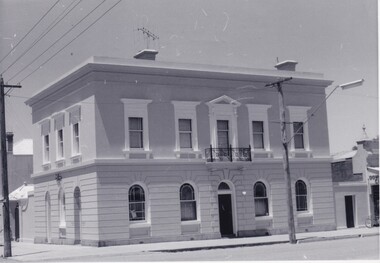
Photograph, Saunders, Unknown
The photograph depicts the two-storey building of the Bank of Victoria which was built in 1858 and was replaced in 1867 after a fire destroyed the original building. The branch had originally opened under John Farran in 1856 before the office building was erected in Beechworth. The building was located on the corner of Ford and Camp streets and embodied the dignified appearance of Beechworth during the mid-1800s due to the building's features. The Bank of Victoria was designed by "Smith and Watts" and built from white brick and render, which cost three thousand and seven hundred pounds to construct. The building was inspired by a formal Italian villa, including square-headed windows, cornices, and a parapet. The ground floor consisted of banking chambers, a strong room, and servants' quarters. The residential quarters were located on the second floor.The photograph is significant as it depicts not only depicts a building of importance to the town of Beechworth but it also shows aesthetic significance due to the style it was built in. As the Bank of Victoria was constructed in the classic Italian style, it exemplifies the classic quality and refined manner of this architectural style. This building style represents the image Beechworth held for itself at that time, which was a sophisticated and distinguished town.Black and white rectangular photograph printed on paper.Reverse: 23/80 / Beechworth / (Indecipherable) / Banking to (Indecipherable) / Sydney / “Bank of Victoria” / BMM 8692.1 / [Stamped: ILFORD]bank of victoria, beechworth, banks, beechworth bank, 1858, 1867, ford street, camp street, victoria, john farran, smith and watts, italian architecture, italian style building, brick building, brick, banking, money, fire, building destroyed -
 Federation University Historical Collection
Photograph - Colour, Steve Bracks, Premier of Victoria, opens the University of Ballarat Arts Academy, Camp Street, 22/07/2008
The University of Ballarat inherited the Camp Street Arts Precinct. As the functions of the former public buildings were moved elsewhere, the Victorian Government of the time recognised the importance of maintaining the heritage buildings and the opportunity to create a cultural precinct extending from the Art Gallery. The 19th century architecture along Lydiard Street and the dogleg bend of Camp Street define the precinct. With substantial financial assistance from both State and Commonwealth Governments, the Art Gallery Ballarat has been extended through to include the 1884 Police Station on Camp Street. The Post Office building (1864-1887) was acquired for the University. The 1904 and 1941 Courthouses and the c1900 Public Library building were also included. Two new buildings have been constructed. These six buildings will house the University's Visual and Performing Arts Programs.3 Panorama photograph of the opening of the University of Ballarat Arts Academy, Camp Street. .2 Poster .1) L to R Kerry Cox (Vice Chancellor); Brendan Nelson (Federal Minister - Education); Chancellor David Caro; Steve Bracks, Premier of Victoria. Photographer Ian Reiduniversity of ballarat, camp street, victorian government, commonwealth government, ballarat fine art gallery, police station, courthouse, public library, post office, art gallery ballarat -
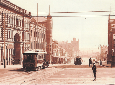 Melbourne Tram Museum
Photograph - Bourke St from William St looking west - cable trams, c1910
Photograph shows the view from William St looking west along Bourke St. Has two cable tram sets in the view, along with on the south side of Bourke Street the former St. James Building, Gollin & Company Building, then over King Street, Bourke Street West Police Station, McLean Bros. & Rigg Ironmongery & Hardware Store, (later Hudon's Store) and the Tramways Head Office Building. On the northside of Bourke Street is the Massey-Harris Building, John Connell & Co. Pty Ltd "Gresham House" and over King Street, H.V. McKay Harvester's Sunshine Head Office. Also in the distance is the Spencer Street Railway Station buildings. The Archway visible through the St. James Building led into the former Lt. James Street. Yields information about Bourke Street between 1909 and 1913Photograph - sepia toned on A4 sheetHas TMSV Sales stamp on rear.trams, bourke st, william st, cable trams, tramways, tram 402, st. james building -
 Royal District Nursing Service (now known as Bolton Clarke)
Photograph - Photograph, black and white, Barry Sutton, 22.06.1977
Royal District Nursing Service (RDNS) Sisters worked from this, their rented Collingwood Centre at 98 Charles Street, Collingwood, which opened in 1977. The Sisters left each morning taking any sterilized equipment needed with them to carry out their nursing visits in a specific area (district), They returned at the end of the day to write up their patients nursing histories, clean and reset any equipment used ready for re-sterilization, and contact other medical and community personal as necessary. From its inception as Melbourne District Nursing Society (MDNS), in 1885, their Trained nurses (Nurses) worked in specific areas, 'districts'. The first Nurse worked east and west, between Victoria Parade and Flinders Street and, north and south, between Spencer Street and Spring Street. When a second Nurse was employed they divided this area at Elizabeth Street so each Nurse could attend to patients in the same area giving continuity of care. Gradually over the years, Melbourne District Nursing Service (MDNS), later known as Royal District Nursing Service (RDNS) from 1966 when they received Royal patronage, opened Centres throughout the Melbourne Metropolitan area and outer suburbs with Heidelberg Centre opening in 1971. Their Trained nurses (Sisters) left from these Centres each morning to carry out their nursing visits in a specific area (district), taking any sterilized equipment needed with them. They returned at the end of the day to write up their patients nursing histories, clean and reset any equipment used ready for sterilization, and contact other medical and community personal as necessary. Through its expansion quality of care was not lost, the RDNS nursing staff gave best practice care in many fields of nursing and to people of many cultures with their patients ranging in age from babes, children, adults to the elderly. Some of the care provided was – Post-Natal care, Diabetic Care, Wound Care, Giving of injections and medications, Catheterizations on children and adults, Stoma care, Dementia care, Palliative Care, General care, Rehabilitation, Spinal care, Cystic Fibrosis care, Haemo-Oncology care, Home Enteral Feeding care, and IV therapy at home. Assisting with rehabilitation with an aim towards independence remained at the forefront of the Sister’s minds. All care included giving advice and support to the patient and their Carers. Black and white photograph showing the front facade of the Royal District Nursing Service (RDNS), Collingwood Centre. It is a Victorian style, single story, light coloured painted concrete faced building built around the 1870s. To its left is the front wooden door with a small central glass section in the upper center, and a wire door in front of this. To its right is an Electricity Department meter attached to the wall, and under this a large "98" and to its right, and a little lower is an attached rectangular white sign, with black capital letters, saying "Royal District Nursing Service" and below this in smaller letters "Collingwood". To the right sits a long sash window with dark frame. At either end of the building white concrete face extensions, with embellishments, support a corrugated iron straight veranda roof, with wrought iron embellishment attached to its outer edge. This sits above the window and door and runs along the building protecting the small porch. Above this, along the building, is deep decoration, including a row of concrete balusters and above and central is a concave shell shaped structure. A short dark metal spiked fence runs along the edge of the narrow garden bed. In the foreground the footpath and part of a road can be seen. A small bare tree can be seen on the left hand side of the building and a small bush on the right hand side.Photographer stamp. Quote No. DO 66royal district nursing service, rdns, rdns centre -
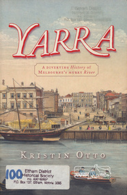 Eltham District Historical Society Inc
Book, Kristin Otto, Yarra : a diverting history of Melbourne's murky river / Kristin Otto, 2005
"It was John Wedge, Batman's private surveyor, who named the Yarra Yarra. In September 1835 he was at the Turning Basin with some Kulin and heard them identify the river as it came over the Falls as, he wrote, 'Yarrow Yarrow'. It was only some months later that Wedge discovered they had been referring to the pattern and movement of water over the Falls, not the river itself. And ever since, it has been the Yarra's fate to be misunderstood: maligned for its muddiness, ill-used as sewer and tip; scooped, sculpted, straightened and stressed, 'cleaned up' to the detriment of its natural inhabitants; built-over, under and beside; worked mercilessly and then bridged almost to maritime extinction. In Kristin Otto's superbly entertaining new history, the whole sorry tale is laid bare. From the creation stories of Kulin owners and geologist blow-ins (and Robert Hoddle's bad-tempered expedition to the headwaters) to the twenty-first-century waterside building boom, Otto traces the course of Melbourne's murky river. Erudite, affectionate and witty, with more meanders and diversions than the river itself, Yarra is both a fascinating read and a fitting tribute to the 'noble stream'." -- Publisher's website.Paperback; [viii], 245 p. : illus., maps ; 24 cm.ISBN 1920885781yarra river -
 Ringwood and District Historical Society
Photograph, Ringwood Reserve. Looking to SE Corner and Dickins Store, mid 1960's
3 copies of same photo. Written on backing sheet of one, "Ringwood Reserve. SE corner, 1962". On another "Ringwood Reserve Looking South 1966". On Another: "NBE Corner Rwd Reserve. Building on Right is "Dickins" Facing Melb St. " 1962 -
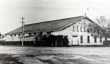 Williamstown High School
Old Naval Drill Hall
Copy of black and white photograph mounted on board. Accompanied by a captionCaption reads: The Old Naval Drill Hall Assemblies, physical education, social occasions and fund-raising activities happened in this old hall. Some other buildings on the site were used for classrooms and examination areas when there was no space left on the school site.drill hall, williamstown high school, 1960s -
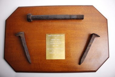 Dandenong/Cranbourne RSL Sub Branch
Souvenir - Burma Rail Bridge Bolt & Railway Spikes.On wooden plaque
Plaque with metal railway bridge bolt and 2 metal railway line spikes.Spikes have lip on top to hold rail lines down with chisel shaped ends to by driven into sleepers. Metal bolt used to hold railway sleepers to bridgesNo markings on spikes or bolt. Plaque brass plate engraved-: BURMA RAILWAY BRIDGE BOLT & RAILWAY SPIKES Recovered 1987 By Ex P.O.W V.X. 30397 BILL TOON Approximatly 7,000 Australians Lost Their Lives Building This Railway Line 1942-1945. -
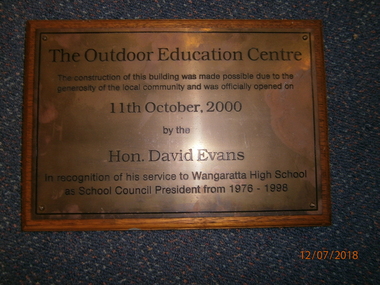 Wangaratta High School
WHS Building Opening Plaque, 2000
Rectangular wooden plaque with a bronze metal plate on the front and black engraved text reading:The Outdoor Education Centre The construction of this building was made possible due to the generosity of the local community and was officially opened on 11th October, 2000 by the Hon. David Evans In recognition of his service to the Wangaratta High School as School Council President from 1976-1998 -
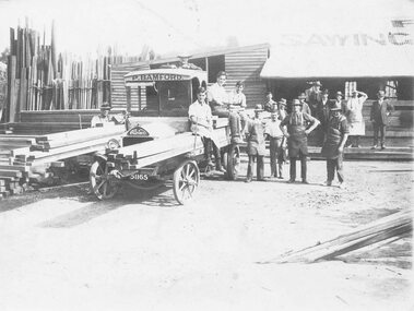 Ringwood and District Historical Society
Photograph, Maroondah Highway Central, Ringwood. Bamford's Timber Yard, c.1915
Black and white photograph (3 copies- 1 large, 2 smaller) Typed below large photograph: "Bamford's Timber Yard. Cnr. Warrandyte and Main Rds. (Later to become Safeway Site). c1915". Image shows men standing outside building. Timber stacked to left and utility vehicle with P. Bamford written on cabin. -
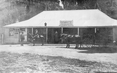 Kiewa Valley Historical Society
Photo - Lagoon Hotel Kiewa - C.A. White
Kiewa is a country town located on the Kiewa River. The hotel was built to supply the local people and those beyond with goods. The hotel continued operating until the 1970s.The town, Kiewa, is in the Kiewa Vally. Lawson's store was a busy place in the 1860s supplying goods to settlements up the river valleys. The Kiewa Post Office opened in 1871. Both businesses continued to operate as the town grew, the post office still providing a service to the local community.Black and white photo of C. A. White's Lagoon Hotel next to the Kiewa Post Office. This photo is published on pages 41 and 42 of 'A History of the Kiewa Valley' by Esther Temple and David LloydOn the back 'From Mrs E. Temple ' Tangambalanga 3691 / President of Kiewa Valley Historical Society' And below - 'Lagoon Hotel, Kiewa / Built by James Lawson 1860 / Post Office opened March 1871 / Building destroyed by fire Jan. 21st 1971'kiewa town, lagoon hotel, kiewa post office, james lawson -
 University of Melbourne, Burnley Campus Archives
Album - Digitised, Joanne Morris, Visit to Burnley April 2014, 2014
Collection of digitised photographs taken in preparation for the Class of 1973 Reunion in 2014. Garden views and buildings. Donated by Joanne Morris, former student, in June 2014. See Digitised photos- Garden Views folder- Visit to Burnley April 2014. (1) Luffmann Ponds. (2) Administration Building. (3) Emily Gibson Beds and Ginkgo biloba. (4) Looking towards Native Garden. (5) Oak tree. (6) Looking towards Rose Garden. (7) Looking towards Stream Garden and Fern Garden. (8) Looking towards Rose Garden. (9) Plaque at entrance to Field Station. (10) New gates at entrance to Field Station donated by the Friends of Burnley Gardens. (11, 12) Field Station. (13) Plaque in Herb Garden commemorating Enid Carberry. (14) Fountain in Herb Garden commemorating Enid Carberry. (15) Forestry Building. (16-18) Inside Forestry Building. (19) Sugar Gum Table Setting donated by the Friends of Burnley Gardens. (20) Plaque on Sugar Gum Table commemorating Geoff Olive. (21, 22) View of Luffmann Ponds and Summer House. (23) Plaque at Luffmann Ponds. (24) Luffmann Ponds. (25) View of former Egg-Curator's Residence from Nursery. (26) Back of Nursery. (27,28) The Burnley entry for the Melbourne International Flower and Garden Show 2014. (29) Back of Administration Building. (30) Plant Science Laboratories. (31) Student Amenities Building. (32-34) Plant Science Laboratories. (35) Citriodora Court. (36) Eucalyptus maculata at entrance to Native Garden. (37) Native Garden, James Hitchmough Grasslands. (38) Garden view. (39) Inside the Hall. (40,41) Roof Garden. (42,43) Library. (44-50) Views of the Quad and classrooms. (51) Dairy. (52) Building 904,(Centre for Urban Horticulture) now Waterway Ecosystem Research Group. (53) Yarra Boulevard entrance.class 1973, class reunion, garden views, buildings, joanne morris, students, luffmann ponds, administration building, emily gibson beds, ginkgo biloba, native garden, oak tree, rose garden, stream garden, fern garden, field station, friends of burnley gardens, plaques, herb garden, enid carberry, fountain, forestry building, sugar gum table, geoff olive, summer house, egg-curator, residence, nursery, melbourne international flower and garden show, 2014, plant science laboratories, student amenities building, citriodora court, eucalyptus, james hitchmough grasslands, roof garden, library, quad, classrooms, dairy, centre for urban horticulture, waterway ecosystem research group, yarra boulevard entrance -
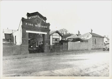 Kew Historical Society Inc
Photograph, Kew Fire Brigade, Walton Street, c.1912
The Walton Street Fire Brigade building was constructed in 1893 (Rogers, 1973) replacing an earlier building on the site constructed for the Kew Volunteer Fire brigade. The building was demolished in 1941. In the background of the photo is a nouse on the corner of Peel and Walton Street which was also constructed in 1893 and which was to house a fireman from the brigade.This work forms part of the collection assembled by the historian Dorothy Rogers, that was donated to the Kew Historical Society by her son John Rogers in 2015. The manuscripts, photographs, maps, and documents were sourced by her from both family and local collections or produced as references for her print publications. Many were directly used by Rogers in writing ‘Lovely Old Homes of Kew’ (1961) and 'A History of Kew' (1973), or the numerous articles on local history that she produced for suburban newspapers. Most of the photographs in the collection include detailed annotations in her hand. The Rogers Collection provides a comprehensive insight into the working habits of a historian in the 1960s and 1970s. Together it forms the largest privately-donated collection within the archives of the Kew Historical Society.A photographic print of the Kew Fire Brigade, presumably copied from W.D. Vaughan's 'Kew's Civic Century' (1960)."2nd Fire Brigade, Walton St., taken shortly before Belford Rd., built. (Demolished). 2nd fire brigade, Walton St., Kew. No photo of 1st except on membership certificate."kew fire brigade, walton street - kew -
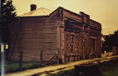 Buninyong Visitor Information Centre
Photograph - Folio of Photographs, Old Buninyong Library
Images of the Old Buninyong Library show the building in a semi-dilapidated condition. The images were taken fifteen before the efforts began to restore the building for public and commercial use. Refer to the Information Folders within the BVIC Archives records for further information. The Buninyong Community website includes a brief history of the building. A red folder containing a group of photographs of the Old Buninyong Library taken by Barry Cox in October 1964. Old Buninyong Libraryold buninyong library, heritage buildings, libraries, heritage preservation -
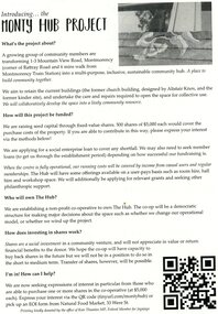 Greensborough Historical Society
Document - Leaflet, Introducing the Monty Hub Project, 2021 c
Proposal to develop the site with existing buildings at 1-3 Mountain View Road Montmorency as a community hub. The buildings are a former church and kindergarten designed by Alistair Knox. 2 p., printed in black both sides on off white paper, plan, photographmontmorency hub, monty hub project -
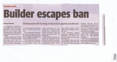 Greensborough Historical Society
Newspaper Clipping, Diamond Valley Leader, Builder escapes ban, 24/05/2017
A Building practitioner who defied orders and is under investigation by the Victorian Building Authority is still allowed to practice, infuriating home owners in Diamond Creek's Rangeview Estate.News article 1 page, black text.diamond creek, rangeview estate -
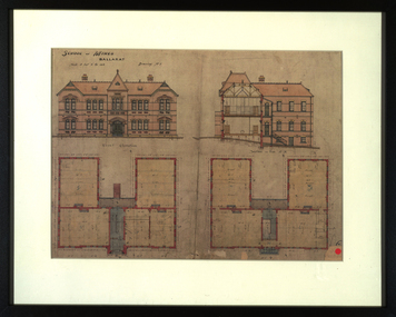 Federation University Historical Collection
Drawing - Architectural Drawing, Plans for the Ballarat School of Mines New Classrooms, c1899 (print), c1899
The new classrooms at the Ballarat School of Mines were started in 1899 and completed in 1901. In 2014 this building is known as The Administration Building on the Federation University Australia SMB Campus.Framed print of original plans for new double storey classrooms at the Ballarat School of Mines. The plans include the front elevation and a side section.ballarat school of mines, buildings, administration building, new classrooms, prov, plans, architecture, architectural drawings, a building -
 Galen Catholic College
Galen Catholic College Art & Technology Extension, 2000
The intense development of buildings and other infrastructure of the 1990s at Galen Catholic College continued into the 2000s. In 2000, new Art & Technology wings were added to the main building.galen catholic college, galen college, art, art classrooms, technology, technology classrooms, demolition, development -
 Robin Boyd Foundation
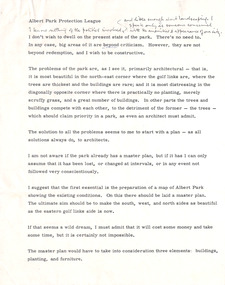
Document - Manuscript, Robin Boyd, Albert Park Protection League
Criticism of the state of Albert Park, Melbourne, preparation of a current map, the need for a Master Plan of buildings, plantings, furniture. Criticism of buildings. Suggests a plan to plant and paint.This appears to be a lecture.Typewritten with pencil edit and notes, quarto, 4 pages. (Two copies)Small paper square included with Monday, January 24 calendaralbert park, macrobertson girls high school, planting, building, furniture, robin boyd, manuscript -
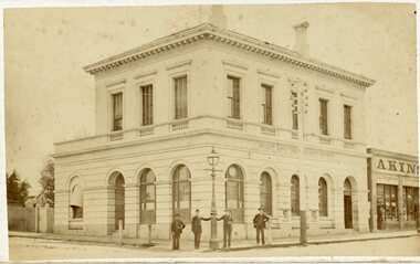 Stawell Historical Society Inc
Photograph, Stawell Post Office Cnr Wimmera and Main Street
The Stawell Post office, an impressive building by any standards. It was built in 1875. It's Foundations are solid granite and cost ₤1300. the completed building cost over ₤ 4500.Stawell Post Office on Corner of Wimmera and Main Street. Four men standing on the corner two either side of A Gas Lamp stawell, post office -
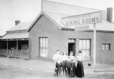 Stawell Historical Society Inc
Photograph, Schneider's boarding house cnr. Victoria & Georges Street. Stawell c 1901
Schneider’s Boarding House with family group outside building Corner of Victoria Street and St Georges Street. Building was also the Victorian Coffee Palace, then the Doll Factory.Two photos of the Schneider Family outside their boarding house and beside a sign Dinning Rooms, on the corner of Victoria St. & George St. Stawell. c 1901. The small photo is a black & white photo, the other a enlarged print of the same photo in a purply colour.Written on the enlarged print, beside the image is the wording "When Peter died in 1901 Isabella was left to support fer family. Charles was only one year old so Isabella ran a Boarding House at the corner of Victoria St. & George St. Stawell".stawell business -
 Unions Ballarat
Photograph - Photographs: New Flag Poles - Trades Hall - 2018, 26 April 2018
The Ballarat Trades Hall building was erected in 1887 - the foundation stone being laid on 15 October of that year. The photographs show new flag poles that were installed to the building on 26 October 2018. Flags shown in the photos are the Red Flag and the Flag of the Southern Cross. Scaffolding was erected to undertake restoration of the building façade. Significant to the character of the Ballarat Trades Hall building.Electronic photographs - jpeg.ballarat trades hall, ballarat regional trades and labour council, btlc, flags - red, flags - southern cross, flags - btlc, building works -
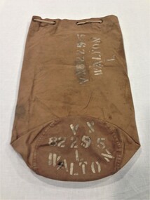 Montmorency/Eltham RSL Sub Branch
Accessory - Kitbag, Australian Army, WW2
Held by Montmorency/Eltham sub branch for some time; background details uncertain. Likely donated by by family member. Owner was Leslie 'Rocky' Walton (b. 9 Jun 1921) who enlisted at Casino (NSW) on 2 Aug 1942, living at East Preston at the time. He was discharged on 15 April 1946 while posted to 2/43 Aust. Inf. Bn.The kitbag consists of a long, brown, canvas cylinder closed at the bottom. The top has an internal canvas flap and eight brass grommets to allow a drawstring type rope (fitted on this item) to securely close the bag. A metal D-shaped hinged clasp (see photo; 13 cm x 8 cm) to enable fitting of a padlock. A canvas loop (see photo) is sewn to bottom edge of bag to enable rope to be passed through for bag to be slung on shoulder. The name and army serial number of the owner are stenciled in white paint on the side and bottom of the bag. Stenciled on side and bottom of bag ... VX82295 WALTON Laccessory, personal items