Showing 32282 items
matching building
-
 Malmsbury Historical Society
Photograph (Item), Mhs At Cemetery Working Bee C1995, Malmsbury c1995
Associated with - Mhs Buildings - Graves -
Malmsbury Historical Society
Photograph (Item), Mhs At Cemetery Working Bee C1995, Malmsbury c1995
Associated with - Mhs Buildings - Graves -
Malmsbury Historical Society
Photograph (Item), Mhs At Cemetery Working Bee C1995, Malmsbury c1995
Associated with - Mhs Buildings - Graves -
Malmsbury Historical Society
Photograph (Item), Malmsbury Structures, Malmsbury ca2003
Associated with - M.H.S Buildings - Structures -
Malmsbury Historical Society
Photograph (Item), Hand Emroidered & Collectables Display, Malmsbury ca1990
Buildings - Malmsbury Town Hall -
Malmsbury Historical Society
Photograph (Item), Kerosene Lamp & Collectables, Malmsbury ca1990
Buildings - Malmsbury Town Hall -
Malmsbury Historical Society
Photograph (Item), Collectables Display, Malmsbury ca1990
Buildings - Malmsbury Town Hall -
Malmsbury Historical Society
Photograph (Item), Collection Of Old School Records & Photo's, Malmsbury c1990
Buildings - Malmsbury Town Hall -
Malmsbury Historical Society
Photograph (Item), "Chamber Pots, Jug & Water Basin's", Malmsbury ca1990
Buildings - Malmsbury Town Hall -
Malmsbury Historical Society
Photograph (Item), Craft Exhibition At Malmsbury Heritage Week, Malmsbury ca1990
Buildings - Malmsbury Town Hall -
Malmsbury Historical Society
Photograph (Item), Crochet & Tapestry At Malmsbury Heritage Week, Malmsbury ca1990
Buildings - Malmsbury Town Hall -
Malmsbury Historical Society
Photograph (Item), Ceramic Display At Malmsbury Heritage Week = 1exh0052r, Malmsbury ca1990
Buildings - Malmsbury Town Hall -
Malmsbury Historical Society
Photograph (Item), Quilting Display At Malmsbury Heritage Week, Malmsbury ca1990
Buildings - Malmsbury Town Hall -
Malmsbury Historical Society
Photograph (Item), Artefacts Collection At Malmsbury Heritage =1exh0073r, Malmsbury ca1990
Buildings - Malmsbury Town Hall -
Malmsbury Historical Society
Photograph (Item), Display Collection At Malmsbury Heritage = 1exh0071r, Malmsbury ca1990
Buildings - Malmsbury Town Hall -
Rutherglen Historical Society
Door lock
Presumably from a Rutherglen buildingLocking and opening mechanism for a door, with brass knobs & keyhole but no key, with snip for locking on inside. In working order.door lock, locking mechanism -
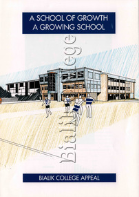 Bialik College
Booklet (Item) - Bialik College Appeal c1992 booklet
School Appeal for building funds1990s, judaism, bialik college -
 Buninyong & District Historical Society
Photograph - Original Photograph, Crown Hotel, Buninyong, from Learmonth St. in 1980's
Historic building in 1980'sColour photo of Crown Hotel Buninyong from Learmonth St. in 1980's. Original polychrome brickwork painted dark blue in 1960, and then cream after alterations 1980. Chimneys unpainted, show original brickwork.buninyong, crown hotel -
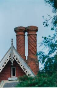 Buninyong & District Historical Society
Photograph - Original Photograph, Clifton Villa (1859) Eyre St. Buninyong, close-up of chimneys, 9/11/1991
detail of feature of historic buildingColour photograph, Clifton Villa (1859) Eyre St. Buninyong, close-up of chimneys.buninyong, clifton villa, chimney -
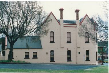
 Buninyong & District Historical Society
Photograph - Original Photograph, Clifton Villa (1859) Eyre St. Buninyong, front (east side), 9/11/1991
historic building, after restorationColour photograph, Clifton Villa (1859) Eyre St. Buninyong, front (east side), 3/4 view.buninyong, clifton villa, chimney -
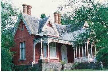
 Buninyong & District Historical Society
Photograph - Original Photograph, Clifton Villa (1859) Eyre St. Buninyong, front (east side), full on, 9/11/1991
historic building, after restorationColour photograph, Clifton Villa (1859) Eyre St. Buninyong, front (east side).buninyong, clifton villa, chimney -
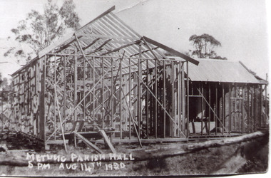 Lakes Entrance Historical Society
Photograph - Metung Hall, 1920
Building of Hall commenced 1920.Black and white photograph of the Metung Parish Hall under construction. Metung VictoriaMetung Parish Hall 5pm August 14 1920, Working Beereligion, halls -
 Lakes Entrance Historical Society
Photograph - Bruthen Cottage Hospital Main Street Bruthen Victoria, M Holding, 1/07/2009 12:00:00 AM
This building is now a private home.Colour photograph of old Bruthen Cottage Hospital Main Street Bruthen Victoriaaccommodation -
 Flagstaff Hill Maritime Museum and Village
Document - Framed Poster, Borough of Warrnambool, Victoria, Australia, after 30/06/1875
This document, also referred to as a word picture or Tablet, is framed in glass and timber with gilt trim, is handwritten with colour highlights. The penned letters rest on ruled guide lines, decorated where the lines intersect. The writing gives a description of the state of Borough of Warrnambool around 1875; its location, the area it covers, its population, Harbour and facilities, public buildings and institutions, imports and exports, financial worth, number of houses, connection with other areas of the Colony. A possible reason and origin for the document is found in an article ‘Link with US Exhibition’ from the Warrnambool Standard of December 19, 1981, written by local historian Bruce Morris. The writer mentions that the Warrnambool Borough Council met on 15th June 1875 and recorded a letter from G.C. Levey , secretary to the Melbourne group of commissioners representing the Colony, and Victoria in particular, for the Philadelphia Centennial Exhibition of 1876. The letter asks Council to provide “statistics as to the population, social condition and commercial and industrial state of the district in and around Warrnambool.” A sub committee was formed for the project. The Mayor, Cr. Thomas King, wrote and signed a Report, presented to the council on July 14, 1875, in which “The Committee … begs to recommend that a Tablet be prepared setting for the particulars respecting the following matters relating to the Borough”. The matters included area, population, annual income, churches, schools, other public buildings, societies and companies, general description of houses erected, and returns of exports and imports for 1874. The minutes note that the Report was adopted. The article above also notes the opinion of Warrnambool printers who have examined the document; it is almost certainly to be an old lithograph, which means there could be several copies. It is possible that there may be a copy in Melbourne and another in Philadelphia. It is interesting to note that (1) the quoted location co-ordinates are for an “Unnamed Road, Packsaddle NSW 2880, Australia”, and that the DMS co-ordinates for Warrnambool’s Council Offices differ, being 38.23.9.12 South, 142.28.52.887. (2) the date for “Exports and Imports for the Year Ending 30th June 1875” is different to the period mentioned by Cr. King in the sub committee’s Report of recommendation “returns of exports and imports for 1874”. The information required to have the figures for the end of June 1875 would need to have been compiled very quickly for the Tablet to be ready for the opening of the Philadelphia Exhibition on 10 May 1876. The document/certificate shows the following – - - - - - - - - - - - - - - -- - - - - - - - - - - - - - -- - - - - - - - - - - - - - -- - - - - - - - - - - - - - - “Victoria Australia, Borough of Warrnambool. Latitude, 30.24.50 South, Longitude 142.32 East The Principal Port in the Western District of the Colony and the Centre of its Choicest Agricultural Lands. Established a Municipality in 1855, and Created a Borough 1863. Population in 1875 4,500. Warrnambool is the nearest Port to Melbourne on the Western Seaboard, being about 160 miles distant. Coaches run to and from the Metropolis daily, in connexion [connection] with the Railway of Geelong and Steamers belonging to Local Companies sail between Melbourne, Warrnambool, Belfast [renamed Port Fairy], and Portland several times weekly. The Harbour is known as Lady Bay, and is partially protected by a reef of rocks stretching from the mouth of the Hopkins River. The formation of a Breakwater has been decided upon by the Government, to extend 600 yards, at an estimated cost of £100,000. There are two substantial Jetties, one of 800 and the other of 600 feet in length. The former is connected with the Town by means of a Tramroad, along which Goods, inwards & outwards, are conveyed, & the latter has been constructed solely for the purpose of facilitating the transit of material for the formation of the Breakwater. In addition to the trade of the Borough and District, the principal Townships up country receive their supplies from Melbourne and ship their exports through Warrnambool. Potatoes form the staple produce of the district, and the richness of the soil can be estimated by the fact that the Government Statistics for 1875 give as the average yield a return of Seven Tons to the acre. Several thousand acres between Warrnambool and Tower Hill are now being laid down in Potatoes by Tenants who have leased the lands at rates up to £5 per acre for the season 1875-6. Wool, Tallow, hides &c are also largely exported, while the shipments of all descriptions of Farm Produce are annually increasing. Area of Borough, 3362 Acres. Net Annual Value £27,000. Annual Revenue £5,500. Number of Houses in Borough 800. Public Buildings and Institutions Churches. Church of England, Roman Catholic, Presbyterian, Wesleyan, Congregational and Baptist. Schools. Three State Schools, average attendance nearly 1000. New Building in course of erection. Several private establishments. Banks. Bank of Australasia, Bank of Victoria, National Bank, Colonial Bank and Savings Bank. Public Buildings. Court house, Custom house, Post & Telegraph Offices, Survey & Land Offices, Shire £, Town Hall, Mechanics Institute, Volunteer Orderly Room, Odd Fellows Hall, Hospital & Benevolent Asylum, Temperance Hall &c. Companies & Societies. Steam Navigation Co, Woolen Mill Co, Gas Co, Racing Club, Amateur Turf Club, Agricultural Society, Farmers’ Club, Cricket Club, Anglers’ Society, Building Society, Freemasons Odd Fellows, Foresters, Druids, Hibernians. Protestant Alliance, Rechabites, Sons of Temperance, &c, Fire Brigade &c. --- Exports and Imports for the Year Ending 30th June 1875 –-- --Exports Total Tonnage 27,800 (Calculated at the Current Warrnambool Market Prices) Potatoes Wool Wheat Barley Hides Skins Fowls Butter Cheese Eggs Tallow Leather Ale Pigs Sheep Sundries --Imports 13,000 Tons Of the Estimated Value of £520,000 Total Tonnage of Exports and Imports 40m900 Tons, Value £806,627 Passenger Travels, to ad from Warrnambool during year, 10,000 persons Revenue from all sources paid through Warrnambool Sub Treasury From 1860 to June 1875 £1, 292, 300 Thomas King [signed] Mayor Henry T Read [signed] Town Clerk” - - - - - - - - - - - - - - -- - - - - - - - - - - - - - -- - - - - - - - - - - - - - -- - - - - - - - - - - - - - - The document is of historical, social, economic and local significance in that it summarises activities, business, community, trade, travel and government at a point in time in Warrnambool’s history – 30th June 1875.Document, also referred to as a ‘word picture’ or ‘tablet’. Document is framed in glass and timber with gilt trim, handwritten with colour highlights. The penned letters rest on ruled guide lines, decorated where the lines intersect. Document outlines the establishment of Warrnambool as a Municipality in 1855 and Borough in 1863, with a population of 4,500 in 1875. It states geographic location, public buildings and institutions, harbor facilities and imports and exports for the year ending 30th June 1875. Two signatures "Thomas King" Mayor and "Henry T Read" Town Clerk. It shows the Coat of Arms of the Borough of Warrnambool.Signatures - "Thomas King" Mayor and "Henry T Read" Town Clerk. Warrnambool Coat of Arms; “British Coat of Arms, above sailing vessel and sheaf of wheat in sun, motto “By these we flourish” and around circumference “Borough of Warrnambool 1855”flagstaff hill, warrnambool, shipwrecked coast, flagstaff hill maritime museum, maritime museum, shipwreck coast, flagstaff hill maritime village, great ocean road, borough of warrnambool, municipality of warrnambool, document borough of warrnambool 1875, word picture of warrnambool 1875, tablet of borough of warrnambool 1875, statistics borough of warrnambool 1875, lithograph borough of warrnambool 1875, coat of arms warrnambool, warrnambool city motto – in these we flourish, establishment of warrnambool, warrnambool history, thomas king mayor of warrnambool, henry t read town clerk of warrnambool, warrnambool breakwater, warrnambool jetty, warrnambool imports and exports 1875, warrnambool agriculture 1875, warrnambool business 1875, warrnambool population 1875, centennial exhibition philadelphia 1876, framed certificate -
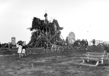 Surrey Hills Historical Society Collection
Photograph, Bonfire, Beckett Park, Balwyn (Surrey Hills), c1937/8, 1937
"The bonfire at Beckett Park was the culmination of the EMPIRE DAY/CELEBRATIONS in Surrey Hills in 1935 and 1936. In 1937 vandals lit the fire prematurely but residents hastily rebuilt it - about / 100 tons including old tyres. A volunteer fire-watcher had his caravan close by until lights-up time on Saturday night. / Courtesy Ian Barkla. / see 180 (handwritten on backing board)." / "BONFIRE BUILDING at BECKETT PARK/EMPIRE DAY CELEBRATIONS IN 1930s/ The celebrations were centred on the/ shopping centres in Surrey Hills and/Mont Albert to boost local business (and/ the spirits of residents) after the Depression./ - from a glass negative - Mr Ian Barkla."Image depicting the building of a large bonfire made primarily from rubber tyres, supported by a wooden frame c1937/8. There is a significant crowd of people watching the erection of the pyre from ground level. Several members of the crowd are seated or holding bicycles. There are multiple persons situated on the pyre or on a ladder propped up against the mound of tyres. The area containing the pyre has been fenced off with rope (?). A white coloured caravan in situated to the right (facing) of the bonfire in close proximity to a dark coloured car. Two stone towers and a park bench are also visible in the image.Black and white, W 25.3 cm x H 20.3 cm, landscapeparks and reserves, beckett park, balwyn, bicycles, crowds, empire day, depression 1929-1939, economic depression, frank leslie barkla, bonfires -
 Sunbury Family History and Heritage Society Inc.
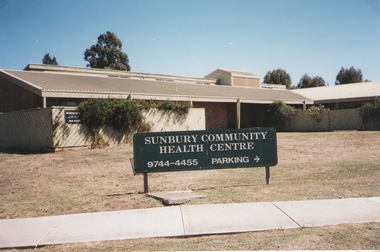
Photograph, Elwyn Davis, Former Sunbury Community Health Centre, March 2002
The first Sunbury Community Health Centre was built on the corner of Horne Street and Gap Road in a temporary building. As result of further funding in 1974, a permanent building was erected and opened in 1981 and operated from that site until 2000 when it was relocated into a larger and more modern building on the former Sunbury Primary School site in Macedon Street to accommodate Sunbury's expanding population and needs.It now operates under the name of Sunbury and Cobaw Community Health Centre. The old building was demolished and replaced with a fast-food outlet.A non-digital coloured photograph of the Sunbury Community Health Centre showing the notice board displayed in the front giving phone details and parking area.sunbury community health centre, health centres, gap road, horne street -
 Orbost & District Historical Society
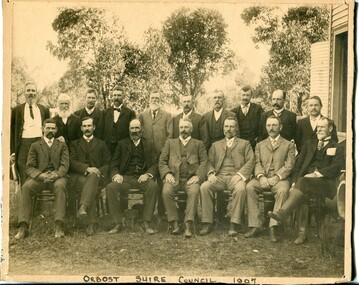
black and white photograph, Howard D. Bulmer, 1907
This photograph shows the Orbost Shire Council in 1907. In the back row are : A. Hillyard; John Draffin (sec.); David Jonson; Archie Rodwell; Hugh Cameron; Geotge Nixon; J. Hassett; Percy Watt; Wm Anderson (engineer); Wm Ross (S.R. Mail) Seated in front on chairs are : Sam Lynn; R. Pearse; John Johnston; Henry Luke (pres.); Donald Munro; Bill Cumming; Charles Grove The shire covered an area of 9,347 square kilometres and existed from 1892 until 1994 when it became part of the East Gippsland Shire Council. Orbost was at first included in the Bairnsdale Shire from 1882 and was later part of the Tambo Shire. Because of travelling distances the Croajingalong Shire was created in 1892 (name changed to Orbost Shire 17.2.1893 with James Cameron as the first Shire President. In 1994 it amalgamated to become part of East Gippsland Shire Council.This item is associated with the Orbost Shire Council. The shire covered an area of 9,347 square kilometres and existed from 1892 until 1994 when it became part of the East Gippsland Shire Council. A large black / white photograph of a group of men in two rows - front row seated; back row standing. The photograph has been taken outdoors with trees in the background and to the right a wooden building and tank. There is a copy.on front - "Orbost Shire Council - 1907" on back - "March, 1907, Shire Council"orbost-shire-council-1907 local-government -
 Ringwood and District Historical Society
Flyer, Executor's Auction Subdivision Advertisement, Lilydale Road and Oban Road, Ringwood East, Vic. - 1937
Single page advertisement for Executor's Auction of land in Ringwood East on Saturday, May 29, 1937 with locality map showing 26 building sites for auction highlighted in brown, and brief summary of local services available. Subdivision includes Old Lilydale Road, Joseph Street, Dynes Street, Albert Street (later Wyrunga Street), Carcoola Road, and Mount Dandeong Road. (Carcoola Road incorrectly shown as Oban Road on the subdivision plan). Auctioneer - C.E. Carter, (Phone Ringwood 24. -
 Bendigo Military Museum
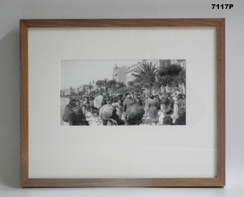
Photograph - PHOTOGRAPH FRAMED - WW1, Wayne Eels, C.2008/2009
The Grinton Collection. Promenade along the Mediterranean coast of Nice France. Refer Cat No. 1280 for Jack Grintons service details. Photograph framed. Photograph - black and white photograph on paper. Depicting - a promenade space filled with civilians seated and standing with a background of tree and buildings. Frame - timber, light varnish finish, Perspex front, cardboard backing."Group 3: Trip of a Lifetime". "D. Promenade des Anglais".framed accessories, camera on the somme, 38th bn, grinton, ww1, nice -
 Kiewa Valley Historical Society
Papers - Hollonds' Family and their memories, 2013
The Hollonds' family were original settlers in the Kiewa Valley at Mulagong. Their descendants owned land in Tawonga, Tawonga South and between the East and West of the Kiewa river. Hollonds had a cattle run on Mt Fainter which was later given to the Hicks family.Members of the Hollonds family lived, worked and married in the Kiewa Valley. These papers describe the connection to the families and the Kiewa Valley.Typed papers donated by the Hollonds' family covering: The Hollonds Family History, Cattlemen, 'Snowy' Miller, Mrs Hollonds' Boarding house, SEC Depot at Tawonga, building of Bogong Township, Early Scenes on the Kiewa Scheme.hollonds family, tawonga station, cattlemen, mt beauty land, tawonga boarding house