Showing 10949 items matching "lander"
-
 Eltham District Historical Society Inc
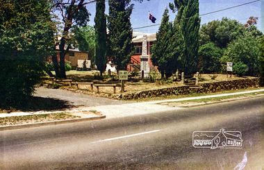
Photograph, Eltham RSL and Uniting Church, Main Road, Eltham, c.1979, 1979c
Changing streetscape - RSL branch merged with Montmorency. Land sold and since developed into units.Roll of 35mm colour negative film, 6 stripsUnidentified; half-frame numberingmonuments, church, eltham rsl sub-branch, eltham uniting church, main road -
 Eltham District Historical Society Inc
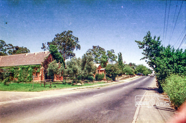
Photograph, Eltham RSL and Uniting Church, cnr John Street and Main Road, Eltham, c.1979, 1979c
Changing streetscape - RSL branch merged with Montmorency. Land sold and since developed into units.Roll of 35mm colour negative film, 6 stripsUnidentified; half-frame numberingmonuments, church, eltham rsl sub-branch, eltham uniting church, main road, john street -
 Eltham District Historical Society Inc
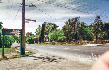
Photograph, Eltham RSL and Uniting Church, looking from cnr of Pitt Street and Main Road, Eltham, c.1979, 1979c
Changing streetscape - RSL branch merged with Montmorency. Land sold and since developed into units.Roll of 35mm colour negative film, 6 stripsUnidentified; half-frame numberingmonuments, church, eltham rsl sub-branch, eltham uniting church, main road, pitt street, eltham community centre -
 Eltham District Historical Society Inc
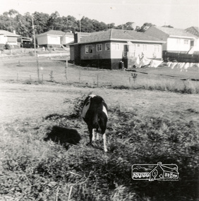
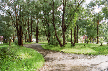
Photograph, Vacant land between Beattie Street and Hoban Avenue, Montmorency, c.1952, 1952c
Digital copy of black and white photograph38 beattie street, montmorency, hoban avenue -
 Eltham District Historical Society Inc
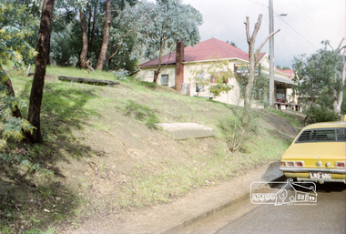
Photograph, Vacant land at 816 Heidelberg-Kinglake Road, Hurstbridge, c.1980, 1980c
Streetscape evolution; prior to development of reserve for housing units and redevelopment of shops opposite Hurstbridge Railway StationRoll of 35mm colour negative film, 4 stripsKodak GB 200 5096streets, heidelberg-kinglake road, hurstbridge, railway station -
 Eltham District Historical Society Inc
Photograph, Milk Bar at 808 and vacant land at 816 Heidelberg-Kinglake Road, Hurstbridge, c.1980, 1980c
Streetscape evolution; prior to development of reserve for housing units and redevelopment of shops opposite Hurstbridge Railway StationRoll of 35mm colour negative film, 4 stripsKodak GB 200 5096streets, heidelberg-kinglake road, hurstbridge, milk bar, bendigo bank, railway station -
 Eltham District Historical Society Inc
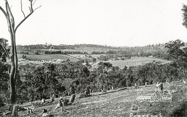
Photograph, Tom Prior, Clearing land at Research
Main Road is in the distance with the aqueduct following the pine trees at top of photo. Doney's store is visible near the road.The Reynolds family were early settlers in Research. The Reynolds/ Prior collection of photographs were taken by Tom Prior, the maternal uncle of Ivy Reynolds, around 1900 and the 60 photos in the album give a fine overview of many of the landmarks of Research and Eltham over 100 years ago. lvy lived in the family home for many years at 106 Thompson Cres Research. Ivy's father, Ernst Richard Reynolds and grandfather, Richard Reynolds, lived at the same address. Ivy's father Richard worked for Mr. Trail on his property in Research. Reynolds Road is named after the family. Mr Tom Prior (wife Eva) worked at the Melbourne zoo. He was very innovative and made his own camera, using the black cloth hood to exclude the light. The photographs are a reminder of the rural nature of Research and Eltham and its rich heritage. Black and white photograph mounted in an album, the Reynolds/Prior Photograph Collection, this being one of 53 reproduced black and white images of early Eltham.The Reynolds/Prior Photograph Collection, Presented to the Eltham District Historical Society, 14 June 2006 by Ross McDonald. A second copy was also presented to the Andrew Ross Museum, Kangaroo Groundreynolds prior collection, research (vic.) -
 Eltham District Historical Society Inc
Photograph, Vacant land between Beattie Street and Hoban Avenue, Montmorency, c.1952, 1952c
Digital copy of black and white photograph38 beattie street, montmorency, hoban avenue -
 Kiewa Valley Historical Society
Photos - King Family Collection
The King family lived in Tawonga South where my older brother and sister went to school. We lived over the road from Wally Madison's farm. Later when a house became available, we moved into Valley Avenue, Mt Beauty. This is when I turned 5 and started my schooling. It was a long walk for a 5 year old as I remember. Then later we moved to 50 Lakeside Ave. I remember we loved living there as it was close to the school, footy ground and kindergarten. My father, Ted King, wad a carpenter and was involved in the building of many houses in Mt Beauty which was the home for the workers on the Kiewa Electric Scheme. So as they are part of the history of Mt Beauty I thought they may be useful to you as part of the history. The tennis photos, I vaguely remember Lou Hoad and Ken Rosewell giving exhibition matches in Mt Beauty. I may stand corrected on this, but I do remember my parents who were keen tennis players themselves were most excited at seeing these famous tennis players. As I was only 9 when we left Mt Beauty to live in Dimboola I still remember the shock of leaving a beautiful mountainous county side and arriving in a flat farming land next to a desert and seeing windmills One thing I do remember from school is, once a week (or fortnight) the teacher used to come around with a jar of little white pills, of which we were all to take. I really don't know what they were?? or for?? I also remember being taught to swim in the freezing cold river by a Mrs Smith who wore black bathers and wore her hair in a bun...... ...I am now in my 70s My father used to also carve intricate trays and jewellery boxes in his spare time. I think they were used for tennis trophies. by Diane Werner.x33 photos of small black and white photos of the Tawonga, Tawonga South and Mt Beauty - Photos not labelled but described as follows. See each photo for a possible label. A. Tawonga? B. Mt Beauty taken on the road to Bogong ? C. SEC Works D. Industrial buildings with mountains in the background E. Building site with wooden frame and 3 men F. Buildings with power poles G. Building site with lots of huts H. Buildings under construction I. Group of houses in the distance J. Group of houses in the distance K. Group of people in front of a building L. Group of 8 men sitting on timber planks, corrugated iron at back. M.& N. Building site with floor and upright timbers O. Mountain view with camp site in foreground P.& Q. Buiding site, several houses R.5 men at a building site S. portable building on trailer T & U. Mountain view V. Building site W. Group of men, car and mountains in background X. Cows Y. Pigs Z. 2 men standing next to cars. AA. Football players BB. Man painting a corrugated iron building CC. Football DD. Men in front of a building EE Buildings with mountains in background FF & GG Tennis payersHH & II. Electricity infrastructure -
 Kiewa Valley Historical Society
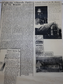
Booklets and Papers - St Joseph's Catholic Church Mt Beauty, St Joseph's Catholic Church Mt Beauty Golden Jubilee 1954-2004
Catholics from Tawonga attended Mass at Dederang the area being part of the Myrtleford parish. With the coming of the State Electricity Commission and the increase in population Masses were said in various schools, homes and halls between Tawonga and Mt Beauty until the completion of St Joseph's ChurchSt Joseph's Catholic Church, Mt Beauty was consecrated on November 7th 1954. The SEC allocated land to each of the churches for them to provide their own places of worship. It was built by volunteers who donated money and their time to raise funds and build the church.1. Booklet with yellow cover, black print and 28 pages back to back held by 2 staples. 2. Booklet "Mass to Celebrate the 40th Anniversary of St Joseph's Church Mt Beauty 1954-1994" 4 pages back to back 3. Papers: vary - 1. A3 sheet with articles from newspapers "Catholic Church Opens At Mt Beauty"; "Catholic Church for Mt. Beauty". 2. x4 A4 sheets typed back to back -"Recalling the first 40 years" 3. St Joseph's Mt Beauty 1968-69 Lawn Cutting Roster 4. Miscellanious st joseph's mt beauty, catholic church, golden jubilee, religion -
 Kiewa Valley Historical Society
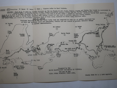
Map - Kiewa Hydro Electric Works Area
An early map of the Kiewa Hydro Electric Scheme Works Area prepared by the SECV for use when requesting access to the area. The regulations are printed regarding permits.During construction of the KHES there were restrictions on access to the area. This map identifies the land marks and states the regulations for entry to the area.Black and white map folded into three showing a legend with the townships, camps, gates and dams marked.Also indicating the roads, rivers, mountains and infrastructure of the KHES. khes works area, map of khes -
 Kiewa Valley Historical Society
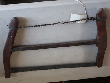
Buck Saw
A bucksaw is a hand powered frame saw similar to bow saw and generally used with a sawbuck to cut logs or firewood to length (bucking).Used by residents of the Kiewa Valley for clearing land, chopping firewood, cutting lumber. Also used while camping because it is portableFormerly UKV 239. Buck Saw with Lightning Tooth Blade. Operated by two men.Ref. Page 10 Tools for all Trade Catalogue. It consists of 3 horizontal bars, the top one being twisted wire and the bottom one being the metal blade with a wood bar in between. They are attached at each end to curved wooden bars. tool for wood, saw, buck saw -
 Kiewa Valley Historical Society
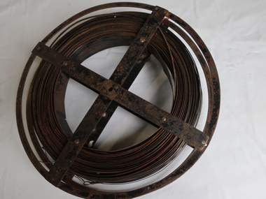
Surveyors Chain - Steel Band
A chain is a unit of length equal to 66 feet or 22 yards. This is a statute measure in the United Kingdom. One link is 100th part of a chain, which is 7.92 inches (20.1 cm). The chain and link became standard surveyors' units of length and crossed to the colonies from the United Kingdom. The chain is the unit of linear measurement for the survey of the public lands as prescribed by law. In Australia most building lots in the past were a quarter of an acre, measuring one chain by two and a half chains. Also street frontages, roads, laneways. The chain also survives as the length of a cricket pitch, being the distance between the stumps. Surveyors and residents of the Kiewa Valley used the Steel Band Surveyors Chain to measure distances when developing the land.Surveyors' steel band measuring tape, known as a 'standard band', or a 'steel band chain'.This chain consists of a long narrow strip of steel of uniform width of 3 mm and thickness of 0.3 to 0.6 mm. The chain itself is between 20 m and 30 m long.surveyors, surveyors chain, measurement of distance -
 4th/19th Prince of Wales's Light Horse Regiment Unit History Room
Booklet, Australian Government Printing Service, Australian Army Manual of Land Warfare Part 2 Infantry Vol 9 Pam 4 Marksmanship 1995, 1995
A hard covered plastic covered loose leaf booklet providing instructors, coaches and firers in all corps with the practical and theoretical information applicable to marksmanship with infantry weapons.7610-66-136-4218marksmanship -
4th/19th Prince of Wales's Light Horse Regiment Unit History Room
Booklet, Australian Army Manual of Land Warfare Part 2 Infantry Vol 4 Pam 9 5.56 mm Austeyr Individual Weapon Family F88,F88C, F88S & Grenade Launcher, 1997
A hard covered loose leaf booklet providing instructors with material to teach the maintenance, handling and shooting skills of the 5.56 mm Austeyr Individual Weapons Familysteyr -
4th/19th Prince of Wales's Light Horse Regiment Unit History Room
Booklet, Manual of Land Warfare Part 2 Infantry Training Vol 6 Pam 2 Short Range Ant Armour Weapon 84 mm L14A1 (Carl Gustaf), 1984
A soft covered booklet providing information to train soldiers on the weapon7610- 66 -120- 434284 mm carl gustaf, anti-armour -
4th/19th Prince of Wales's Light Horse Regiment Unit History Room
Booklet (6 copies), Manual of Land Warfare Part 2 Infantry Training Vol 7 Pam 1 Mine, Anti-Personnel M18A1 (Claymore), 1979
A soft covered booklet providing information required to conduct training in siting, setting up, firing, neutralising and disarming the Mine, Anti-Personnel M18A1, Claymore . One copy has amdts 1 & 2. One copy has amdt 1.7610-66-099-2474mine, claymore -
4th/19th Prince of Wales's Light Horse Regiment Unit History Room
Booklet, Manual of Land Warfare Part 2 Infantry Training Vol 7 Pam 2 Grenades and Pyrotecnics, 1984
A soft covered booklet providing the information required to conduct training with the (then) current in-service grenades and pyrotechnics in the Australian Army.7610-66-117-4186grenades, pyrotechnics -
4th/19th Prince of Wales's Light Horse Regiment Unit History Room
Booklet, Manual of Land Warfare Part 2 Infantry Training Vol 1 Pam No 1 The Infantry Battalion 1984, 1984
A soft covered booklet providing the doctrine for the employment of the infantry battalion in war.7610-66-118-5958infantry battalion training doctrine, infantry battalion training doctrine -
4th/19th Prince of Wales's Light Horse Regiment Unit History Room
Document, Australian Army Manual of Land Warfare Part Two Armour Training Vol 3 Armament Pam 2 Fire Support Vehicle (Scorpion), 1980's
Possibly a draft. A yellow paper covered document stapled top LH corner - an introduction to the Scorpion Armoured Fighting Vehicle and its armamentsscorpion, armament, scorpion, armament -
4th/19th Prince of Wales's Light Horse Regiment Unit History Room
Booklet, Manual of Land Warfare Part 1 Vol 1 Pam No 6 Administration in the Area of Operations, 1977
A soft covered booklet describing the principles, responsibilities and systems forming forming the basis of administration in the area of operationsDSN 761-66-093-7742war administration -
4th/19th Prince of Wales's Light Horse Regiment Unit History Room
Booklet, Manual of Land Warfare Part 1 Vol 1 Pam No 3 The Arms and Services 1983, 1983
A soft covered booklet describing the roles, characteristics and tasks of a standard infantry division and associated corps troops units that may be allocated in support.DSN 7610-66-117-2315the army division, the army division -
4th/19th Prince of Wales's Light Horse Regiment Unit History Room
Booklet (2 copies), Manual of Land Warfare Part 1 Vol 6 Pam No 1 Staff Duties in the Field 1979, 1979
A soft covered booklet covering the duties of Command Staff designed as reference for all officers, in particular grade two and three offices at formation level.DSN 7610-66-100-5660staff duties -
4th/19th Prince of Wales's Light Horse Regiment Unit History Room
Booklet, Manual of land Warfare Part 2 Infantry Training Vol 2 Pam No 2 Infantry Commanders' Aide-Memoire 1987, 1987
A plastic covered aide-memoirs for field useDSN 7610-66-129-9744infantry aide-memoire -
4th/19th Prince of Wales's Light Horse Regiment Unit History Room
Training Pamphlet, HQ Training Command - Army, Australian Army. The Musorian Armed Forces. Army Trials Doctrine 4.3 Edition 1 Version 1 Land Operations, Tactics, Techniques and Procedures, Dec 1997
For training purposes "The Enemy" was a notional country called Musoria A plastic bound book. The aim of this doctrine is to provide a notional enemy capable of undertaking conventional and unconventional operations. The training enemy, the Musorian Armed Forces, is capable of a range of threats.00010 ATD 4.3 Ed 1 Ver 1training doctrine, the enemy, musorian armed forces -
4th/19th Prince of Wales's Light Horse Regiment Unit History Room
Document, Servicing Schedule for Trucks Utility 3/4 Ton GS FFR Land Rover, Oct 1972
Used by the unit in servicing of vehiclesDocument, 4 pages, stapled detailing the servicing schedule and lubrication chart for the Landrover GS FFRSection 4 Insert No 58 AB 416 (Adapted)landrover, servicing -
 Kiewa Valley Historical Society
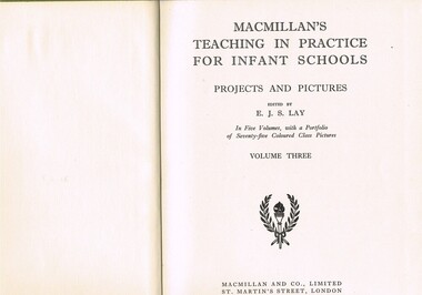
Book - Reference Teaching Infants, MacMillan and Co., Limited, MacMillan's Teaching in Practice for Infant Schools Projects and Pictures Vol. 3, 1949 (exact)
This book was used in the first school in Mt Beauty only started in 1948/1949 this would have been one of the first books used in the school. Also as a state school book it is also significant to the Victorian State school system. There could be a lot of these books in other towns in the state, therefore it may not be just found in Mt Beauty. This item is historically significance as it shows what sort of books were used for that period. It is socially significant as the Mt Beauty school was new in this period therefore shows what the students were using. This item was used in Mount Beauty Primary School as part of a teacher's curriculum. The fact that it was in a rural area, Kiewa Valley did present a slightly different learning atmosphere than in the larger towns and cities. The majority of parents within the Kiewa Valley, had slight reservations of the "high and mighty" attitude of some city dwellers and the effectiveness of city bred teachers was how to overcome these ingrained mores. The mentioning of European nations and lifestyles was to the pupils in the infant schools far more like "fairyland" than the realism that they experienced on the "land". However at this age level fantasy was more important than reality. Australian fantasy tales e.g. Blinky Bill (circa 1930s) introduced main characters that infants could identify, especially in rural schools.This item is a green coloured hard backed book containing 384 double sided pages. Nearly all pages have black writing and free hand sketches. There are some pages of duplicated sheet music.See KVHS 0045, KVHS 0046, KVHS 0048 for the other volumes held.On the spine is "MACMILLANS TEACHING IN PRACTICE" below this "PROJECTS and PICTURES" underneath "VOL 3". On title page "edited by E.J.S.Lay" underneath"VOLUME THREE". Below this there is printed a two branch wreath within these an "Olympic" type torch.book, school, teacher, children, infant, reference, educational -
 Kiewa Valley Historical Society
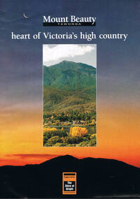
Poster Brochure, Mt Beauty Tawonga Heart Of Victoria's High Country, Circa 1995
The Item is a pictorial time piece of the valley and usage, farms,industry,town area, vegetation and winter snow levels Historical and the social-economical development at circa 1995 of land usage and residential buildings style.Major social events e.g. Festival of the Bogong Moth and the Mt Beauty Mardi Gras. It is also a good historical record of tourism campaigns of the Alpine Shire and Mt Beauty Chamber of Commerce. Also see "KVHS 0125"Brochure folds out from a 20.5cm x 29.5cm to 82cm x 29.5cm poster type documentinside panoramic photo of snow tipped alpine mountain range incorporating the Mount Beauty township, farming area of the Kiewa Valley and relevant tourist orientated informationtourism mt beauty tawonga photographs, victorian alps -
 Kiewa Valley Historical Society
Photograph of Kiewa Valley Panorama, Kiewa Valley from No. 5 Road, Before 1945
In 1943 a camp for workmen was erected and a commencement made with the erection of plant storage and workshop buildings in the new township of Mt. Beauty. The photograph was probably taken after the completion of these buildings. There is no sign of construction of the town itself. In the latter part of 1945 work was commenced on the Mt. Beauty township area with a medical centre, general trading store and some houses under construction. The No. 5 Road, from where the photograph was taken, is the road to West Kiewa Power Station and Big Hill Scenic Lookout.Is an excellent view of the Kiewa Valley before there was little work undertaken to establish the town of Mt. Beauty. Farming was well established with the evidence of huge areas of cleared land. The junction of the East and West Kiewa Rivers can be clearly seen. The first Workmen's camp is near the river and some workshop buildings can also be seen. Black and white photograph of the Kiewa Valley, looking North.Handwritten on the back of photograph "Kiewa Valley from No. 5 Road".kiewa valley, camp, buildings, mt. beauty -
 Kiewa Valley Historical Society
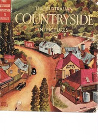
Book - Reference Countryside, The Australian Countryside in Pictures, circa 1950s
This book is a "snapshot" in time (1950s) detailing life in Australia covering a time when a "man's word and handshake" were his moral and quasi legal bond, and the now relative defunct saying "smoko" (having a "time out" from work for a cigarette and tea or coffee). The book spans an era where the male was still the "head" of the family even though for a majority of families the women took on the many "male only" roles during the World War II period. This shift in the leadership of the family hierarchy is mentioned, so ever slightly, (not to offend the still predominant macho male image) in both rural and city environments. The effects of the war, and later the push for women's emancipation and equality in both family, social, workplace and political areas of life, since this book was published, is now finally resolved. However there are still some sections of the recent migrate population where this male dominance is causing a few problems.The significance of this book is not only because it was donated by Mrs C. Roper ( from the Roper Family, a pioneer Kiewa Valley and surrounding Region family - originally beef cattle graziers) but also a Kiewa Valley resident and family, experiencing the shift in the social and economical life of post World War II rural Australia. The strong heritage link to this region of many families still residing within its boundaries, is a clear affirmation of the bond that the Kiewa Valley and its Regions have upon family unity. This unity within the rural environment is something that is attracting more and more families from sometimes alienating city life.This printed coloured sketched, or painted paper sleeve of the book is freely wrapped over a dark red hard cover. Into the front of the cover is pressed a standing pose of a farmer with long sleeves rolled up over his elbows. Behind him and to the right are what appears to be three sacks of wheat and next to him is a merino sheep. To the left and down are two dogs one with a fox in its jaws. The book contains 240 pages, 300 illustrations in gravure and 25 pictures in full colour. The inside fly leaf is a colour photograph of a rural scene with dirt road running in the centre and to the left a farm house and a five bay open storage barnOn the tittle page is a signature "C Roper"country life, australian "outback", rural industries, life on the land, swag-man of the bush