Showing 12936 items
matching day
-
 Eltham District Historical Society Inc
Photograph, Hume and Hovell Monument, Broadford, Autumn Excursion, Hume and Hovell's 1824 expedition, 26 May 1996, 26/05/1996
[article by Bettina Woodburn in EDHS Newsletter No. 109, July 1996:] ON THE TRAIL OF HUME AND HOVELL - REPORT ON THE AUTUMN EXCURSION - On a green and fresh morning (Sunday 26th May 1996) the Cobb and Co coach (driven by the most obliging Peter Tampion) set off in a north easterly direction from Eltham to connect with Hume and Hovell's route on their 1824 explorations of central Victoria. The Society would follow a series of monuments erected for the 1924 centenary of the expedition from King Parrot Creek (Tuesday 7th December 1824), through Strath Creek, over Sunday Creek (Sunday 12th December 1824) at Broadford, Tullamarine, St Albans, Deer Park, through Werribee, skirting east of the You Yangs to Lara and Avalon Beach. Because their distance-measuring wheel had broken and a one degree mistake was made in calculations, the two leaders of the original group of six convict-companions arrived at Corio Bay, instead of the expected Western Port, discovered earlier by Flinders. From below Mt. Disappointment (Hume and Hovell's difficulties in "scrambling over brush and rock", "leeches in forest, as well as no water", "cutting grass 4-5 ft. high", dreadful scrub", "devil flies") we took an easier route, saw the Strath Creek memorial in ground fog and a wonderful "field of dreams", the Hume-Hovell privately owned cricket ground with its white picket boundary fence. Now, after a steep climb, in sunshine under gums we stretched and viewed magnificent rolling hills and fog-filled valleys - not "smoke from Aborigines' bush fires". After morning tea at Broadford we followed the Sunday Creek valley beside the Hume Freeway, passed the Wallan Wallan Rest Area (more appropriately Hume and Hovell Rest Area) to tum right at Beveridge. In Gellibrand Hill Park, near the headwaters of the Moonee Ponds Creek, we experienced the landscape the first European settlers saw - huge river red gums and rolling pastures. The gardens and sheltered courtyard of the 1840s, timber, brought from .....[?] prefabricated Woodlands Homestead, provided a pleasant lunch stop. We enjoyed a private tour, panoramic views over Melbourne and surroundings and the excitement of arriving and departing aircraft. Our next river crossing was at Werribee, "in a vast treeless plain", then we drove on by-ways no coach had previously travelled, to find "an immense sheet of water" salty Corio Bay, off-course to the west. In late afternoon of a super, calm, late autumn day we headed homewards. Back at Eltham we were rather surprised to find that we had travelled a total of 347 km. Thanks again to Russell Yeoman for his research and organization. What a wonderful day! Colour photographactivities, broadford, hume and hovell, monument -
 Eltham District Historical Society Inc
Photograph, Strath Creek, Autumn Excursion, Hume and Hovell's 1824 expedition, 26 May 1996, 26/05/1996
[article by Bettina Woodburn in EDHS Newsletter No. 109, July 1996:] ON THE TRAIL OF HUME AND HOVELL - REPORT ON THE AUTUMN EXCURSION - On a green and fresh morning (Sunday 26th May 1996) the Cobb and Co coach (driven by the most obliging Peter Tampion) set off in a north easterly direction from Eltham to connect with Hume and Hovell's route on their 1824 explorations of central Victoria. The Society would follow a series of monuments erected for the 1924 centenary of the expedition from King Parrot Creek (Tuesday 7th December 1824), through Strath Creek, over Sunday Creek (Sunday 12th December 1824) at Broadford, Tullamarine, St Albans, Deer Park, through Werribee, skirting east of the You Yangs to Lara and Avalon Beach. Because their distance-measuring wheel had broken and a one degree mistake was made in calculations, the two leaders of the original group of six convict-companions arrived at Corio Bay, instead of the expected Western Port, discovered earlier by Flinders. From below Mt. Disappointment (Hume and Hovell's difficulties in "scrambling over brush and rock", "leeches in forest, as well as no water", "cutting grass 4-5 ft. high", dreadful scrub", "devil flies") we took an easier route, saw the Strath Creek memorial in ground fog and a wonderful "field of dreams", the Hume-Hovell privately owned cricket ground with its white picket boundary fence. Now, after a steep climb, in sunshine under gums we stretched and viewed magnificent rolling hills and fog-filled valleys - not "smoke from Aborigines' bush fires". After morning tea at Broadford we followed the Sunday Creek valley beside the Hume Freeway, passed the Wallan Wallan Rest Area (more appropriately Hume and Hovell Rest Area) to tum right at Beveridge. In Gellibrand Hill Park, near the headwaters of the Moonee Ponds Creek, we experienced the landscape the first European settlers saw - huge river red gums and rolling pastures. The gardens and sheltered courtyard of the 1840s, timber, brought from .....[?] prefabricated Woodlands Homestead, provided a pleasant lunch stop. We enjoyed a private tour, panoramic views over Melbourne and surroundings and the excitement of arriving and departing aircraft. Our next river crossing was at Werribee, "in a vast treeless plain", then we drove on by-ways no coach had previously travelled, to find "an immense sheet of water" salty Corio Bay, off-course to the west. In late afternoon of a super, calm, late autumn day we headed homewards. Back at Eltham we were rather surprised to find that we had travelled a total of 347 km. Thanks again to Russell Yeoman for his research and organization. What a wonderful day! Colour photographactivities, monument, hume and hovell, murchison valley, strath creek -
 Eltham District Historical Society Inc
Photograph, Murchison Gap viewed from Strath Creek, Autumn Excursion, Hume and Hovell's 1824 expedition, 26 May 1996, 26/05/1996
[article by Bettina Woodburn in EDHS Newsletter No. 109, July 1996:] ON THE TRAIL OF HUME AND HOVELL - REPORT ON THE AUTUMN EXCURSION - On a green and fresh morning (Sunday 26th May 1996) the Cobb and Co coach (driven by the most obliging Peter Tampion) set off in a north easterly direction from Eltham to connect with Hume and Hovell's route on their 1824 explorations of central Victoria. The Society would follow a series of monuments erected for the 1924 centenary of the expedition from King Parrot Creek (Tuesday 7th December 1824), through Strath Creek, over Sunday Creek (Sunday 12th December 1824) at Broadford, Tullamarine, St Albans, Deer Park, through Werribee, skirting east of the You Yangs to Lara and Avalon Beach. Because their distance-measuring wheel had broken and a one degree mistake was made in calculations, the two leaders of the original group of six convict-companions arrived at Corio Bay, instead of the expected Western Port, discovered earlier by Flinders. From below Mt. Disappointment (Hume and Hovell's difficulties in "scrambling over brush and rock", "leeches in forest, as well as no water", "cutting grass 4-5 ft. high", dreadful scrub", "devil flies") we took an easier route, saw the Strath Creek memorial in ground fog and a wonderful "field of dreams", the Hume-Hovell privately owned cricket ground with its white picket boundary fence. Now, after a steep climb, in sunshine under gums we stretched and viewed magnificent rolling hills and fog-filled valleys - not "smoke from Aborigines' bush fires". After morning tea at Broadford we followed the Sunday Creek valley beside the Hume Freeway, passed the Wallan Wallan Rest Area (more appropriately Hume and Hovell Rest Area) to tum right at Beveridge. In Gellibrand Hill Park, near the headwaters of the Moonee Ponds Creek, we experienced the landscape the first European settlers saw - huge river red gums and rolling pastures. The gardens and sheltered courtyard of the 1840s, timber, brought from .....[?] prefabricated Woodlands Homestead, provided a pleasant lunch stop. We enjoyed a private tour, panoramic views over Melbourne and surroundings and the excitement of arriving and departing aircraft. Our next river crossing was at Werribee, "in a vast treeless plain", then we drove on by-ways no coach had previously travelled, to find "an immense sheet of water" salty Corio Bay, off-course to the west. In late afternoon of a super, calm, late autumn day we headed homewards. Back at Eltham we were rather surprised to find that we had travelled a total of 347 km. Thanks again to Russell Yeoman for his research and organization. What a wonderful day! Colour photographactivities, hume and hovell, murchison valley, murchison gap, strath creek -
 Eltham District Historical Society Inc
Photograph, Autumn Excursion, Hume and Hovell's 1824 expedition, 26 May 1996, 26/05/1996
[article by Bettina Woodburn in EDHS Newsletter No. 109, July 1996:] ON THE TRAIL OF HUME AND HOVELL - REPORT ON THE AUTUMN EXCURSION - On a green and fresh morning (Sunday 26th May 1996) the Cobb and Co coach (driven by the most obliging Peter Tampion) set off in a north easterly direction from Eltham to connect with Hume and Hovell's route on their 1824 explorations of central Victoria. The Society would follow a series of monuments erected for the 1924 centenary of the expedition from King Parrot Creek (Tuesday 7th December 1824), through Strath Creek, over Sunday Creek (Sunday 12th December 1824) at Broadford, Tullamarine, St Albans, Deer Park, through Werribee, skirting east of the You Yangs to Lara and Avalon Beach. Because their distance-measuring wheel had broken and a one degree mistake was made in calculations, the two leaders of the original group of six convict-companions arrived at Corio Bay, instead of the expected Western Port, discovered earlier by Flinders. From below Mt. Disappointment (Hume and Hovell's difficulties in "scrambling over brush and rock", "leeches in forest, as well as no water", "cutting grass 4-5 ft. high", dreadful scrub", "devil flies") we took an easier route, saw the Strath Creek memorial in ground fog and a wonderful "field of dreams", the Hume-Hovell privately owned cricket ground with its white picket boundary fence. Now, after a steep climb, in sunshine under gums we stretched and viewed magnificent rolling hills and fog-filled valleys - not "smoke from Aborigines' bush fires". After morning tea at Broadford we followed the Sunday Creek valley beside the Hume Freeway, passed the Wallan Wallan Rest Area (more appropriately Hume and Hovell Rest Area) to tum right at Beveridge. In Gellibrand Hill Park, near the headwaters of the Moonee Ponds Creek, we experienced the landscape the first European settlers saw - huge river red gums and rolling pastures. The gardens and sheltered courtyard of the 1840s, timber, brought from .....[?] prefabricated Woodlands Homestead, provided a pleasant lunch stop. We enjoyed a private tour, panoramic views over Melbourne and surroundings and the excitement of arriving and departing aircraft. Our next river crossing was at Werribee, "in a vast treeless plain", then we drove on by-ways no coach had previously travelled, to find "an immense sheet of water" salty Corio Bay, off-course to the west. In late afternoon of a super, calm, late autumn day we headed homewards. Back at Eltham we were rather surprised to find that we had travelled a total of 347 km. Thanks again to Russell Yeoman for his research and organization. What a wonderful day! Colour photographactivities, hume and hovell -
 Eltham District Historical Society Inc
Photograph, Sign to Hume and Hovell Cricket Ground, at Allandale Road, Strath Creek, Autumn Excursion, Hume and Hovell's 1824 expedition, 26 May 1996, 26/05/1996
[article by Bettina Woodburn in EDHS Newsletter No. 109, July 1996:] ON THE TRAIL OF HUME AND HOVELL - REPORT ON THE AUTUMN EXCURSION - On a green and fresh morning (Sunday 26th May 1996) the Cobb and Co coach (driven by the most obliging Peter Tampion) set off in a north easterly direction from Eltham to connect with Hume and Hovell's route on their 1824 explorations of central Victoria. The Society would follow a series of monuments erected for the 1924 centenary of the expedition from King Parrot Creek (Tuesday 7th December 1824), through Strath Creek, over Sunday Creek (Sunday 12th December 1824) at Broadford, Tullamarine, St Albans, Deer Park, through Werribee, skirting east of the You Yangs to Lara and Avalon Beach. Because their distance-measuring wheel had broken and a one degree mistake was made in calculations, the two leaders of the original group of six convict-companions arrived at Corio Bay, instead of the expected Western Port, discovered earlier by Flinders. From below Mt. Disappointment (Hume and Hovell's difficulties in "scrambling over brush and rock", "leeches in forest, as well as no water", "cutting grass 4-5 ft. high", dreadful scrub", "devil flies") we took an easier route, saw the Strath Creek memorial in ground fog and a wonderful "field of dreams", the Hume-Hovell privately owned cricket ground with its white picket boundary fence. Now, after a steep climb, in sunshine under gums we stretched and viewed magnificent rolling hills and fog-filled valleys - not "smoke from Aborigines' bush fires". After morning tea at Broadford we followed the Sunday Creek valley beside the Hume Freeway, passed the Wallan Wallan Rest Area (more appropriately Hume and Hovell Rest Area) to tum right at Beveridge. In Gellibrand Hill Park, near the headwaters of the Moonee Ponds Creek, we experienced the landscape the first European settlers saw - huge river red gums and rolling pastures. The gardens and sheltered courtyard of the 1840s, timber, brought from .....[?] prefabricated Woodlands Homestead, provided a pleasant lunch stop. We enjoyed a private tour, panoramic views over Melbourne and surroundings and the excitement of arriving and departing aircraft. Our next river crossing was at Werribee, "in a vast treeless plain", then we drove on by-ways no coach had previously travelled, to find "an immense sheet of water" salty Corio Bay, off-course to the west. In late afternoon of a super, calm, late autumn day we headed homewards. Back at Eltham we were rather surprised to find that we had travelled a total of 347 km. Thanks again to Russell Yeoman for his research and organization. What a wonderful day! Colour photographactivities, hume and hovell, allandale road, strath creek -
 Eltham District Historical Society Inc
Photograph, Autumn Excursion, Hume and Hovell's 1824 expedition, 26 May 1996, 26/05/1996
[article by Bettina Woodburn in EDHS Newsletter No. 109, July 1996:] ON THE TRAIL OF HUME AND HOVELL - REPORT ON THE AUTUMN EXCURSION - On a green and fresh morning (Sunday 26th May 1996) the Cobb and Co coach (driven by the most obliging Peter Tampion) set off in a north easterly direction from Eltham to connect with Hume and Hovell's route on their 1824 explorations of central Victoria. The Society would follow a series of monuments erected for the 1924 centenary of the expedition from King Parrot Creek (Tuesday 7th December 1824), through Strath Creek, over Sunday Creek (Sunday 12th December 1824) at Broadford, Tullamarine, St Albans, Deer Park, through Werribee, skirting east of the You Yangs to Lara and Avalon Beach. Because their distance-measuring wheel had broken and a one degree mistake was made in calculations, the two leaders of the original group of six convict-companions arrived at Corio Bay, instead of the expected Western Port, discovered earlier by Flinders. From below Mt. Disappointment (Hume and Hovell's difficulties in "scrambling over brush and rock", "leeches in forest, as well as no water", "cutting grass 4-5 ft. high", dreadful scrub", "devil flies") we took an easier route, saw the Strath Creek memorial in ground fog and a wonderful "field of dreams", the Hume-Hovell privately owned cricket ground with its white picket boundary fence. Now, after a steep climb, in sunshine under gums we stretched and viewed magnificent rolling hills and fog-filled valleys - not "smoke from Aborigines' bush fires". After morning tea at Broadford we followed the Sunday Creek valley beside the Hume Freeway, passed the Wallan Wallan Rest Area (more appropriately Hume and Hovell Rest Area) to tum right at Beveridge. In Gellibrand Hill Park, near the headwaters of the Moonee Ponds Creek, we experienced the landscape the first European settlers saw - huge river red gums and rolling pastures. The gardens and sheltered courtyard of the 1840s, timber, brought from .....[?] prefabricated Woodlands Homestead, provided a pleasant lunch stop. We enjoyed a private tour, panoramic views over Melbourne and surroundings and the excitement of arriving and departing aircraft. Our next river crossing was at Werribee, "in a vast treeless plain", then we drove on by-ways no coach had previously travelled, to find "an immense sheet of water" salty Corio Bay, off-course to the west. In late afternoon of a super, calm, late autumn day we headed homewards. Back at Eltham we were rather surprised to find that we had travelled a total of 347 km. Thanks again to Russell Yeoman for his research and organization. What a wonderful day! Colour photographactivities, hume and hovell -
 Eltham District Historical Society Inc
Photograph, Autumn Excursion, Hume and Hovell's 1824 expedition, 26 May 1996, 26/05/1996
[article by Bettina Woodburn in EDHS Newsletter No. 109, July 1996:] ON THE TRAIL OF HUME AND HOVELL - REPORT ON THE AUTUMN EXCURSION - On a green and fresh morning (Sunday 26th May 1996) the Cobb and Co coach (driven by the most obliging Peter Tampion) set off in a north easterly direction from Eltham to connect with Hume and Hovell's route on their 1824 explorations of central Victoria. The Society would follow a series of monuments erected for the 1924 centenary of the expedition from King Parrot Creek (Tuesday 7th December 1824), through Strath Creek, over Sunday Creek (Sunday 12th December 1824) at Broadford, Tullamarine, St Albans, Deer Park, through Werribee, skirting east of the You Yangs to Lara and Avalon Beach. Because their distance-measuring wheel had broken and a one degree mistake was made in calculations, the two leaders of the original group of six convict-companions arrived at Corio Bay, instead of the expected Western Port, discovered earlier by Flinders. From below Mt. Disappointment (Hume and Hovell's difficulties in "scrambling over brush and rock", "leeches in forest, as well as no water", "cutting grass 4-5 ft. high", dreadful scrub", "devil flies") we took an easier route, saw the Strath Creek memorial in ground fog and a wonderful "field of dreams", the Hume-Hovell privately owned cricket ground with its white picket boundary fence. Now, after a steep climb, in sunshine under gums we stretched and viewed magnificent rolling hills and fog-filled valleys - not "smoke from Aborigines' bush fires". After morning tea at Broadford we followed the Sunday Creek valley beside the Hume Freeway, passed the Wallan Wallan Rest Area (more appropriately Hume and Hovell Rest Area) to tum right at Beveridge. In Gellibrand Hill Park, near the headwaters of the Moonee Ponds Creek, we experienced the landscape the first European settlers saw - huge river red gums and rolling pastures. The gardens and sheltered courtyard of the 1840s, timber, brought from .....[?] prefabricated Woodlands Homestead, provided a pleasant lunch stop. We enjoyed a private tour, panoramic views over Melbourne and surroundings and the excitement of arriving and departing aircraft. Our next river crossing was at Werribee, "in a vast treeless plain", then we drove on by-ways no coach had previously travelled, to find "an immense sheet of water" salty Corio Bay, off-course to the west. In late afternoon of a super, calm, late autumn day we headed homewards. Back at Eltham we were rather surprised to find that we had travelled a total of 347 km. Thanks again to Russell Yeoman for his research and organization. What a wonderful day! Colour photographactivities, hume and hovell -
 Flagstaff Hill Maritime Museum and Village
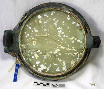
Functional object - Porthole, c 1888
This porthole was part of the ship's fittings when the Antares was constructed. THE ANTARES In mid-November 1914, after the beginning of the First World War, a young local man went one evening to fish near the Bay of Islands, west of Peterborough. He later arrived home hurriedly and in an agitated state declaring: "The Germans are coming!" His family laughed and disbelieved him, as this young fellow was prone to telling fictional tales. About a month later, on December 13th 1914, local farmers Phillip Le Couteur and Peter Mathieson were riding in the vicinity, checking on cattle. Phillip Le Couteur saw what he “thought was the hull of a ship below the cliffs.” He rode to Allansford and contacted police. The next day, two Constables and Phillip Le Couteur returned to the site, where they dug a trench near the top of the cliff and sank a log in it. To this they attached a rope, which they threw down the cliff face. Constable Stainsbury and Phillip Le Couteur then made the dangerous descent down the rope on the sheer cliff face. They found wreckage strewn around a small cove and a portion of a man's body under the cliffs. The hull of the ship could be seen about 300 metres out to sea. Some of the wreckage revealed the name Antares and the remains of the ship's dinghy bore the name Sutlej. During the next two weeks and with the help of the Warrnambool lifeboat and crew, two more bodies were found. Later investigations proved that the tragic wreck was indeed that of the Antares, reported overdue on the 207th day of her voyage from Marseilles, France, to Melbourne. She was a three masted, 1749 ton iron clipper, built in Glasgow in 1888 and originally named and launched as the Sutlej. Bought in 1907 by Semider Bros. from Genoa, Italy, she was refitted and renamed Antares. It was later realised that the local lad who a month earlier had declared he had seen German guns being fired, had probably seen distress flares fired from the deck of the Antares the night she was wrecked. She was last sailed under Captain Gazedo and wrecked at what is now known as Antares Rock, near the Bay of Islands. She had been carrying a large cargo of roofing tiles from France to Melbourne, consigned to Mullaly & Byrne. Many of them are now to be seen amongst the battered and scattered remains of the wreck. Some of the timbers were found to be blackened by fire. An Information Board has been erected on the cliff top near to the site of the Antares wreck, at the end of Radfords Rd, west of Peterborough. (Ref: Flagstaff Hill Maritime Village’s “Antares” fact sheet, Victorian Heritage Database, Information Board at Peterborough, Flagstaff Hill Significance Assessment 2010)The Antares was one of the last of the 'tall ships' to be lost along the south west coast of Victoria, and is the only wreck that took the lives of all people on board. She is listed on the Victorian Heritage Register VHS S34. The Antares is significant as a sail trader carrying an international inbound cargo. It is part of the Great Ocean Road Historic Shipwreck Trail. Porthole with glass, brass, screw dog broken off, glass has cracks through it, some encrustation. Artefact Reg No A/5, recovered from the wreck of the Antares.flagstaff hill, warrnambool, shipwrecked-coast, flagstaff-hill, flagstaff-hill-maritime-museum, maritime-museum, shipwreck-coast, flagstaff-hill-maritime-village, porthole, antares., tall ship, peterborough, 1914 shipwreck, phillip le couteur, peter mathieson, constable stainsbury, sutlej, antares rock., bay of islands, ship's fitting -
 Flagstaff Hill Maritime Museum and Village
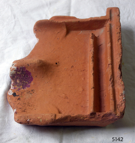
Tile, c 1914
This clay roof tile was part of the ANTARES cargo, a large consignment of tiles on its way to Melbourne. THE ANTARES In mid-November 1914, after the beginning of the First World War, a young local man went one evening to fish near the Bay of Islands, west of Peterborough. He later arrived home hurriedly and in an agitated state declaring: "The Germans are coming!" His family laughed and disbelieved him, as this young fellow was prone to telling fictional tales. About a month later, on December 13th 1914, local farmers Phillip Le Couteur and Peter Mathieson were riding in the vicinity, checking on cattle. Phillip Le Couteur saw what he “thought was the hull of a ship below the cliffs.” He rode to Allansford and contacted police. The next day, two Constables and Phillip Le Couteur returned to the site, where they dug a trench near the top of the cliff and sank a log in it. To this they attached a rope, which they threw down the cliff face. Constable Stainsbury and Phillip Le Couteur then made the dangerous descent down the rope on the sheer cliff face. They found wreckage strewn around a small cove and a portion of a man's body under the cliffs. The hull of the ship could be seen about 300 metres out to sea. Some of the wreckage revealed the name Antares and the remains of the ship's dinghy bore the name Sutlej. During the next two weeks and with the help of the Warrnambool lifeboat and crew, two more bodies were found. Later investigations proved that the tragic wreck was indeed that of the Antares, reported overdue on the 207th day of her voyage from Marseilles, France, to Melbourne. She was a three masted, 1749 ton iron clipper, built in Glasgow in 1888 and originally named and launched as the Sutlej. Bought in 1907 by Semider Bros. from Genoa, Italy, she was refitted and renamed Antares. It was later realised that the local lad who a month earlier had declared he had seen German guns being fired, had probably seen distress flares fired from the deck of the Antares the night she was wrecked. She was last sailed under Captain Gazedo and wrecked at what is now known as Antares Rock, near the Bay of Islands. She had been carrying a large cargo of roof tiles from France to Melbourne, consigned to Mullaly & Byrne. Many of them are now to be seen amongst the battered and scattered remains of the wreck. Some of the timbers were found to be blackened by fire. An Information Board has been erected on the cliff top near to the site of the Antares wreck, at the end of Radfords Rd, west of Peterborough. (Ref: Flagstaff Hill Maritime Village’s “Antares” fact sheet, Victorian Heritage Database, Information Board at Peterborough, Flagstaff Hill Significance Assessment 2010) The Antares was one of the last of the 'tall ships' to be lost along the south west coast of Victoria, and is the only wreck that took the lives of all people on board. She is listed on the Victorian Heritage Register VHS S34. The Antares is significant as a sail trader carrying an international inbound cargo. It is part of the Great Ocean Road Historic Shipwreck Trail. Piece of a clay roof tile recovered from the wreck of the Antares. Has a relief of a horse on back. Artefact Reg No A/7.flagstaff hill, warrnambool, shipwrecked-coast, flagstaff-hill, flagstaff-hill-maritime-museum, maritime-museum, shipwreck-coast, flagstaff-hill-maritime-village, antares, tall ship, peterborough, 1914 shipwreck, phillip le couteur, peter mathieson, constable stainsbury, sutlej, antares rock., bay of islands, clay tile, roofing tile, roof tile -
 Flagstaff Hill Maritime Museum and Village
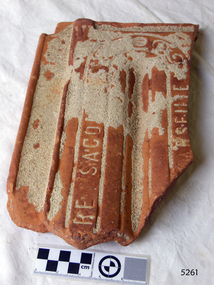
Ceramic - Roof Tile, c 1914
This terracotta clay roof tile was part of a consignment of tiles in the cargo of ANTARES. THE ANTARES In mid-November 1914, after the beginning of the First World War, a young local man went one evening to fish near the Bay of Islands, west of Peterborough. He later arrived home hurriedly and in an agitated state declaring: "The Germans are coming!" His family laughed and disbelieved him, as this young fellow was prone to telling fictional tales. About a month later, on December 13th 1914, local farmers Phillip Le Couteur and Peter Mathieson were riding in the vicinity, checking on cattle. Phillip Le Couteur saw what he “thought was the hull of a ship below the cliffs.” He rode to Allansford and contacted police. The next day, two Constables and Phillip Le Couteur returned to the site, where they dug a trench near the top of the cliff and sank a log in it. To this they attached a rope, which they threw down the cliff face. Constable Stainsbury and Phillip Le Couteur then made the dangerous descent down the rope on the sheer cliff face. They found wreckage strewn around a small cove and a portion of a man's body under the cliffs. The hull of the ship could be seen about 300 metres out to sea. Some of the wreckage revealed the name Antares and the remains of the ship's dinghy bore the name Sutlej. During the next two weeks and with the help of the Warrnambool lifeboat and crew, two more bodies were found. Later investigations proved that the tragic wreck was indeed that of the Antares, reported overdue on the 207th day of her voyage from Marseilles, France, to Melbourne. She was a three masted, 1749 ton iron clipper, built in Glasgow in 1888 and originally named and launched as the Sutlej. Bought in 1907 by Semider Bros. from Genoa, Italy, she was refitted and renamed Antares. It was later realised that the local lad who a month earlier had declared he had seen German guns being fired, had probably seen distress flares fired from the deck of the Antares the night she was wrecked. She was last sailed under Captain Gazedo and wrecked at what is now known as Antares Rock, near the Bay of Islands. She had been carrying a large cargo of roof tiles from France to Melbourne, consigned to Mullaly & Byrne. Many of them are now to be seen amongst the battered and scattered remains of the wreck. Some of the timbers were found to be blackened by fire. An Information Board has been erected on the cliff top near to the site of the Antares wreck, at the end of Radfords Rd, west of Peterborough. (Ref: Flagstaff Hill Maritime Village’s “Antares” fact sheet, Victorian Heritage Database, Information Board at Peterborough, Flagstaff Hill Significance Assessment 2010) The Antares was one of the last of the 'tall ships' to be lost along the south west coast of Victoria, and is the only wreck that took the lives of all people on board. She is listed on the Victorian Heritage Register VHS S34. The Antares is significant as a sail trader carrying an international inbound cargo. It is part of the Great Ocean Road Historic Shipwreck Trail.Part of a terracotta roof tile from the wreck of the Antares Has sand encrusted to bottom of tile. Artefact Reg No A/6.flagstaff hill, warrnambool, shipwrecked-coast, flagstaff-hill, flagstaff-hill-maritime-museum, maritime-museum, shipwreck-coast, flagstaff-hill-maritime-village, antares, tall ship, peterborough, 1914 shipwreck, phillip le couteur, peter mathieson, constable stainsbury, sutlej, antares rock., bay of islands, terracotta tile, roof tile, clay tile, roofing material, building material -
 Flagstaff Hill Maritime Museum and Village
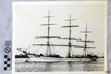
Photograph, 1907-1914
This photograph is of the sailing ship ANTARES at full sail, taken between 1907, when she was named ANTARES, and 1914, when she was wrecked.. THE ANTARES In mid-November 1914, after the beginning of the First World War, a young local man went one evening to fish near the Bay of Islands, west of Peterborough. He later arrived home hurriedly and in an agitated state declaring: "The Germans are coming!" His family laughed and disbelieved him, as this young fellow was prone to telling fictional tales. About a month later, on December 13th 1914, local farmers Phillip Le Couteur and Peter Mathieson were riding in the vicinity, checking on cattle. Phillip Le Couteur saw what he “thought was the hull of a ship below the cliffs.” He rode to Allansford and contacted police. The next day, two Constables and Phillip Le Couteur returned to the site, where they dug a trench near the top of the cliff and sank a log in it. To this they attached a rope, which they threw down the cliff face. Constable Stainsbury and Phillip Le Couteur then made the dangerous descent down the rope on the sheer cliff face. They found wreckage strewn around a small cove and a portion of a man's body under the cliffs. The hull of the ship could be seen about 300 metres out to sea. Some of the wreckage revealed the name Antares and the remains of the ship's dinghy bore the name Sutlej. During the next two weeks and with the help of the Warrnambool lifeboat and crew, two more bodies were found. Later investigations proved that the tragic wreck was indeed that of the Antares, reported overdue on the 207th day of her voyage from Marseilles, France, to Melbourne. She was a three masted, 1749 ton iron clipper, built in Glasgow in 1888 and originally named and launched as the Sutlej. Bought in 1907 by Semider Bros. from Genoa, Italy, she was refitted and renamed Antares. It was later realised that the local lad who a month earlier had declared he had seen German guns being fired, had probably seen distress flares fired from the deck of the Antares the night she was wrecked. She was last sailed under Captain Gazedo and wrecked at what is now known as Antares Rock, near the Bay of Islands. She had been carrying a large cargo of roofing tiles from France to Melbourne, consigned to Mullaly & Byrne. Many of them are now to be seen amongst the battered and scattered remains of the wreck. Some of the timbers were found to be blackened by fire. An Information Board has been erected on the cliff top near to the site of the Antares wreck, at the end of Radfords Rd, west of Peterborough. (Ref: Flagstaff Hill Maritime Village’s “Antares” fact sheet, Victorian Heritage Database, Information Board at Peterborough, Flagstaff Hill Significance Assessment 2010) The Antares was one of the last of the 'tall ships' to be lost along the south west coast of Victoria, and is the only wreck that took the lives of all people on board. She is listed on the Victorian Heritage Register VHS S34. The Antares is significant as a sail trader carrying an international inbound cargo. It is part of the Great Ocean Road Historic Shipwreck Trail. Photograph of the three masted fully rigged Antares at anchor. (ref: Ships A-B SH016.)flagstaff hill, warrnambool, shipwrecked-coast, flagstaff-hill, flagstaff-hill-maritime-museum, maritime-museum, shipwreck-coast, flagstaff-hill-maritime-village, antares, tall ship, peterborough, 1914 shipwreck, phillip le couteur, peter mathieson, constable stainsbury, sutlej, antares rock., bay of islands -
 Flagstaff Hill Maritime Museum and Village
Equipment - Rudder Pintles and Gudgeons, Alexander Hall and Son, ca. 1855
This set of pairs of pintles and gudgeons was recovered from the wreck of the sailing ship Schomberg and was part of its rudder steering system. A reconstruction that includes four pairs is currently on display at Flagstaff Hill. The rudder installation of the Schomberg was almost seven metres tall. A pintle and gudgeon pair is a mechanical fitting that works like a pair of door hinges. One of the uses for this type of fitting is for ships’ rudders. On a ship, one or several gudgeons would be attached to the vertical rudder stempost on the rear of the ship’s hull. On the ship's rudder, an equal number of pintles would be fitted onto it. The rudder assembly would then fit down into the gudgeons on the ship and would be connected to its steering mechanism, allowing it to be moved from side to side and steer the vessel. The SCHOMBERG- The three-masted clipper ship Schomberg was built in 1855 by Alexander Hall and Co in Aberdeen, Scotland, for James Baines' famous Black Ball line. It measured 288 feet (88 meters) in length, with a beam of 45 feet (14 meters), a depth of 29.5 feet (8.99 meters) and 2,284 tons. The mainmast was 210 feet (64 meters) high and the ship carried 3.3 acres of sail. The wooden vessel was constructed with three skins; one planked fore and aft, and two diagonally planked. All skins were fastened together with screw-threaded trunnels (wooden rails). The Schomberg was one of only three clippers wrecked in Victorian waters that operated the England-to-Australia run. It was built to outrun Donald MacKay’s two American-built ships, the Empress of the Sea and the Lightning. It was hoped that Schomberg would make Liverpool to Melbourne voyage in sixty days, setting a record for the voyage. The Schomberg sailed from Liverpool on 6 October 1855 on her maiden voyage, under the command of Captain James Forbes. Her general cargo for Australia included jewellery, spirits, machinery, and 2,000 tons of iron rails and equipment for building the Melbourne to Geelong Railway and a bridge over the Yarra from Melbourne to Hawthorn, and17,000 letters and 31,800 newspapers. She also carried a cow for fresh milk, pens for fowls and pigs, plus 90,000 gallons of water for washing and drinking on board. There were approximately 473 passengers, including migrants for Australia, and a crew of 105. Light winds encountered at the equator dashed the expectations of a record-breaking voyage. On Christmas day the ship sighted Moonlight Head in southwest Victoria and even though there was a deadly combination of wind, currents and unmarked sand spits, the vessel continued on. Then the next day, December 26th 1855, the huge ship gently ran aground on a spit that juts into Newfield Bay, east of Curdies Inlet and the present town of Peterborough. Fortunately, the coastal trader, SS Queen, was nearby and managed to save all passengers and crew. In 1975 Flagstaff Hill’s former Director Peter Ronald and the team of divers recovered many objects and artefacts from the wreck of the Schomberg such as the ship’s fittings, equipment and personal effects including a diamond hidden for years in a communion set. This set of pintles and gudgeons is an example of steering equipment used on ships over 150 years ago, equipment that is still in use in today's shipping industry as well as many other everyday hardware applications.. The equipment is significant for its association with the ill-fated vessel Schomberg, which was wrecked in the local water in 1855 on its maiden voyage. The ship was built for speed and luxury, to sail on journeys with passengers, including migrants, travelling from Liverpool to Melbourne.Pintles and gudgeons, six pairs, plus one single pintle, from the wreck of the SCHOMBERG. Cast iron horse-shoe-shaped fittings with tapered ends. each with metal bars between the long sides. One piece of each pair has a round hollow cylinder and the other has a round solid shank. The single pintle has a tall shank with a pintle hook through it. Some pieces have remnants of grey paint.flagstaff hill, warrnambool, maritime village, maritime museum, shipwreck coast, great ocean road, schomberg, shipwreck, pintles, gudgeons, ship's rudder, ship's steering, clipper ship, james bain, black ball line, alexander hall and co., capt. james bully forbes, rudder pintles and gudgeons, rudder steering, pintles and braces, immigrant ship, maiden voyage, peterborough, 1855, marine technology -
 Peterborough History Group
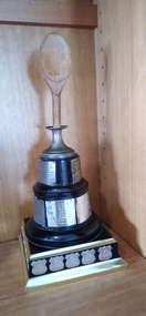
Souvenir - Fred Moore Wooden Spoon Trophy
The Fred Moore trophy is held on Australia Day long weekend. This trophy commemorates the losers, ie the highest score of the day over 12 holes. It began in 1967, and continues. Believed to be donated by Bill Cumming to honour the effort of the players. The event is a non handicap game, so anyone can play, not necessarily golfers. It is still quite a coveted prize. The names on this trophy are not generally found on any other trophies! 1967 L Gatenby G Irvine, 1968 F McIntosh D Morrison, 1969 R Richmond J Wilson, 1970 S Cumming D Urquhart, 1971 S Wilcocks M Koser, 1972 J Murnane D Urquhart, 1973 a. Urquhart P Calvert, 1974 D Mercer A Richmond, 1975 J chirnside D Urquhart, 1976 D McKenzie E Stansfield, 1977 R.A.G Chirnside J Jamison, 1978 T Durham A affleck, 1979 R Grice J.A.S. Chirnside, 1980 WR Jamieson D Calvert, 1981 M Fogarty T Durham, 1982 R Chirnside D Moyle, 1983 T Durham L Cummins, 1984 K Moore P Gray ,1985 I chalingsworth N Kirby, 1986 L Brown C McKenzie, 1987 N Porteous J Gilder, 1988 J Porteous D Morrison, 1989 S Wilkinson T Calvert, 1990 N Gransmaa B Richmond, 1991 K Moore J Pangrazio, 1992 J Fullerton- Healy H McFarlane, 1993 H McCulloch and J Kelly, 1994 A McQueen HW Ryan, 1995 K Reggall J Agar, 1996 Deb Bradshaw D Howe, 1997 J Wilson C Emerson, 1998 N Porteous J Dyson, 1999 G McFeeter K Wallice, 2000 Anthony bell Di Whittaker, 2001 T Smith J Irvine, 2002 Patrick Moore Jill Wilson, 2003 D Howe M Watson, 2004 J Porteous D Fisher, 2005 S Heatherly R Densley, 2006 A Finlay G Burns, 2007 A Campbell M Valmorbida, 2008 S Paton J Austin, 2009 C Ross T Dean, 2010 C McPherson A Cooper, 2011 R Lidgerwood Z Baker, 2012 N Robinson T Custance, 2013 D Hay CW Richmond, 2014 E Chartres A Littlechild, 2015 T Clark M Pithie, 2016 A Campbell J Roxburgh, 2017 P devilee S Borghero, 2018 A Austin H Cumming, 2019 J Brown F Devilee, 2020 R Bell O Wilson, 2021 P Moore S Towell,.The trophy is important because it represents the fact that its a fun, all inclusive day celebrating the Peterborough Golf Club, members and non members, winners and losers!Wooden spoon mounted in a plinth, with metal name plates around the base. the original base was round, with one round base added, and a square base added, to provide more space for the names.Name and dates inscribed on nameplatesgolf, golf tournaments, peterborough golf club, fred moore trophy -
 Bendigo Historical Society Inc.
Document - CORNISH COLLECTION: COPIES OF ARTICLE/BOOK/DOCUMENT RE CORNISH CHURCH HISTORY/LIFE IN BENDIGO, 1866
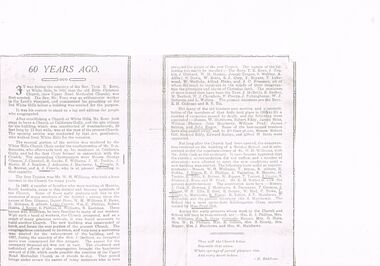
Document. Various copies of article/book/document re Cornish church history/life in Bendigo; a; programme of celebratory activities for Jubilee of Methodist Church and Sunday School, McKenzie Street - 1916 (handwritten note: ''Former Bible Christian'') - various activities for the period Oct 1st to October 9th; shows poor photographic copy of church building and adjacent Sunday School; stapled is letter from Pastor (A E Wellard) and Officers of the church re the celebrations addressed to ''Dear Friend'' with reference to the inauguration of a Thanksgiving Fund.(original of this letter has been cut and repaired with tape (showing up on copy). B. article titled ''60 Years Ago'' - two pages from unknown source with reference to the White Hills Bible Christian Church and the establishment of the church following that in California Gully (Upper Road Methodist Church) - numerous names of choir, early pioneers, ministers of the church, superintendents; c. two pages of information about the ''Back to Upper Road - Diamond Jubilee church, May 1924. Church services on Sunday May 18th; Trustees' Tea Monday 19th May and Children's Day, Sunday May 25th (two services and evening Re-union Tea and Concert - names of ministers and organizers provided. Poor quality reproduction of buildings.buildings, church, methodist church, methodist church. bible christian church. -
 Clunes Museum
Document - TOURELLO POSTOFFICE
TOURELLO POST OFFICE WAS OPENED ON 1ST MAY 1868 AND WAS MOVED TO TOURELLO RAILWAY STATION. THIS WAS 3 KM FROM THE ORIGINAL SITE. ON 8TH OF AUGUST1887 THE ORIGINAL TOURELLO POST OFFICE WAS RE-OPENED AND THE BARREL NUMERAL CANCEL 620WAS RETURNED THERE. ON THE SAME DAY A NEW BARREL NUMERAL CANCEL 1587 WAS ALLOCATED TO TOURELLO RAILWAY STATION. THIS CANCEL IS RATED AS VERY RARE. TOURELLO RAILWAY STATIN POST OFFICE CLOSED ON 6TH JUNE 1950. POST OFFICERS AT TOURELLO RAILWAY STATION WERE:: JAMES DAVEY 1887-1888 JOHN WILLIAM RUSSELL ORR 1888-1893 G KINROSS 1893 JOHN ASMUS 1893-1897 E W BIESKE 1897-1902 NOT KNOWN 1902-1909 W SCARFE 1909-1914 M PURCELL 1914-1915 NOT KNOWN 1916-1925 MRS. STONE 1925-1927 NOT KNOWN 1927-1931 MRS. LIZZIE MCRAE 1931-1938 MRS ROSELINE E CANNY 1938-1950 POST OFFICER AT TOURELLO WERE: D MCDONALD 1868-1874 JAMES MCGREGOR 1874-1876 HENRY JUDKINS 1876-1888 WILLIAM THOMAS MERLIN 1888-1895 TOURELLO POST OFFICE WAS CLOSED ON 1ST APRIL 1895 JAMES MCGREGOR WAS ALSO HEAD TEACHER AT SS740 TOURELLOtourello post office, tourello railway station post office, james mcgregor -
 Federation University Art Collection
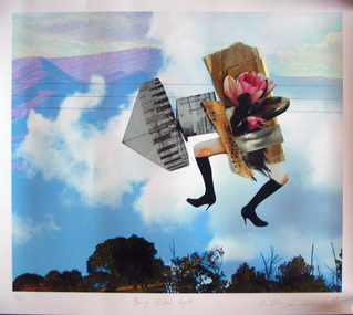
Work on paper - Photocollage, 'Being Ultra Light' by Rochelle Summerfield
Rochelle SUMMERFEILD Born Sydney, Australia This item is part of the Federation University Art Collection. The Art Collection features over 2000 works and was listed as a 'Ballarat Treasure' in 2007.Artists Statement: I am based in Northern NSW. My art practice is deeply influenced by my connections and experiences with the rivers and habitat where I live. Through drawing, paint, collage and digital media my work explores human relationships with riparian environments. Every day I see the undeniable beauty of our rivers as well as the ecological suffering of these riparian landscapes. Historical practices of land clearing, water politics and weed infestation put tremendous pressure on the Australian ecology. Disrupting traditional art forms, I combine them with new technologies to reveal some of the complexities behind human relationships with nature. With bold collagist experimentation, I combine numerous mediums to expose the small revelations between media. These juxtapositions open up the possibilities of reinventing different ways of being with the natural environment. Like the layers in my work, the issues surrounding our riverine environments are multifaceted and complex and begin with individual choices. I want to direct people’s attention to our rivers, to love, appreciate and reconnect with the natural environment. Human experience with nature is a fundamental part of our sense of self, health and well-being as well as community connection. (https://rochellesummerfield.com/about/, accessed 10 June 2020)art, artwork, rochell summerfield, printmaking, print council of australia -
 Wodonga & District Historical Society Inc
Photograph - Codling Collection 01 - The Finishing Touch (previously Arnold’s Produce Store)
Miss Olive Codling was a Foundation Member and a Life Member of the Wodonga Historical Society. Many of her prize-winning photos are held in the Society Collection. She also held a range of roles and committee positions in a wide range of Wodonga community organisations. These included the Horticultural Society, the Wodonga Arts Council, the Wodonga Camera Club and the Wodonga Lapidary Club. This photo collection is significant as it documents how the businesses and buildings in Wodonga have evolved and contributed to community throughout the 20th century.The Finishing Touch, homeware and gifts on the corner of what is now High and Elgin Street. Including John Penny’s Sewing Centre and sewing machine service. At various times it has also been occupied by Elders Real Estate and Jim Matthew's cycles A "Malvern Star" sign is still visible in this photo. It was also previously A. Arnold & Co, General Merchant. In 1924, Arthur Arnold and his father Wilhelm Arnold had established a general store in High Street, near the water tower, but in 1931–32 they moved to new premises in High Street on the corner of what is now known as Elgin Boulevard. In 1933-34 they widened the frontage of the shop and added new premises at the rear for the sale of produce. As customer debt mounted during the depression, it became difficult for Arthur and Wilhelm to re-stock the shop, so they enticed customers into paying their accounts by rewarding them with a small individual cream or milk jug upon payment. The jugs were made in Czechoslovakia and displayed the war memorial, water tower and bandstand from Woodland Grove, Wodonga. The Arnolds continued to trade until they finally closed their store in 1950. Wilhelm Arnold was a brother of J G Arnold, whose business ultimately became the present-day Arnold’s Fruit Market, Wodonga. wodonga businesses, high st wodonga, the finishing touch, a arnold general merchant -
 Bendigo Historical Society Inc.
Newspaper - NEWSPAPER COLLECTION: BENDIGO ADVERTISER
Folder 115 1) Bendigo Onward 1971-2000 2) Bendigo 150 Years 1853-2003 3) Bendigo 175 Years 1836-2011 4) Bendigo Remembers 1945-1995 - August 16, 1995, 5) Anzac Day 1986 "Lest We Forget" - 24 April 1986 6) Creating Our Future. Annual Supplement 2000 7) Bendigo A Capital City. September 27, 1989, 8) Bendigo A Spirit of Achievement. September 25, 1991, 9) Bendigo Back to the Future. June 29, 1998, 10) A Greater Bendigo. September 28, 1994, 11) Bendigo Booming - Region Shines Brightly. 2001 12) Bendigo Booming. August 7, 1996 13) Beautiful Bendigo "Into the Nineties" - September 26, 1990 14) The Bendigo Miner Final Edition - August 23, 2012 15) Bendigo Review - September 24, 1986 16) Centenary of Telecommunication in Bendigo - August 13 17) Bendigo Unlimited - May 7, 1994 18) Bendigo Unlimited - July 10,1982 19) In Bendigo We've Got The Life - September 25, 1985 20) Bendigo City of Golden Opportunity - September 26, 1986 21) Bendigo 160 Years, December 9, 1853-2013newspaper, 'bendigo advertiser -
 Mont De Lancey
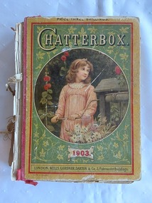
Book, Wells Gardner, Darton & Co. Limited, Chatterbox, 1918
A vintage 1903 Chatterbox collection of puzzles, poetry and stories for children with black lined illustrations and coloured plates throughout.A vintage 1903 hardcover children’s book with the title Chatterbox printed with white lettering at the top of the front cover, which has a green coloured background with an illustration in a large circle showing a girl winding a handle on a wishing well in a garden. The publisher details are printed at the bottom, with Price Three Shillings printed in red letters at the very top. The covers have broken away from the cotton bound spine. The faded light tan coloured back cover has an advertisement for EPPS'S (Breakfast) COCOA. with details of its efficacy and use for good health. The manufacturer details are added at the bottom. Inside the front cover are advertisements for Bird's Custard Powder and Robinson's Patent barley "in powder form". The frontispiece coloured illustration inside depicts a young girl dressed in wintry clothes carrying a lidded cane basket walking along a road on a windy autumn day. The title of the picture is 'Going with the Gale'. The title page has the title plus Edited by J. Erskine Clarke, M.A and publisher details with a black lined illustration of children, a woman with children at her knee reading and flowers. There are further coloured plates in the collection. The book contains plenty of puzzles, poetry, and stories for children. Pp. 412. At the back is an added supplement of Wells, Gardner, Darton & Co's Popular Books. Pp.34.fictionA vintage 1903 Chatterbox collection of puzzles, poetry and stories for children with black lined illustrations and coloured plates throughout. children's books, books, children's stories, adventure stories -
 Melbourne Tram Museum
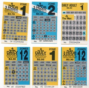
Ephemera - Ticket/s, Metropolitan Transit Authority (MTA), Set of six Scratch type tickets, 1989
Set of six Scratch type tickets, with black printing on yellow / blue printed card and areas where a person could scratch out the month and day of the month areas to validate the ticket. Has the number on the base of the ticket. .1 - 3 hour adult, zone 1 + 2, has been scratched for Feb 6, 4 pm - AO 00210226 .2 - 3 hour concession zone 2, used 9am, 21/6 - CB 02881924 .3 - Daily Adult zone 1+2, used for 9/3, - AK 00207803 .4 - 3 hour concession zone 1, used 4pm, 21/2 - CA 01244046 .5 - Daily Adult zone 1, used 5/6 - AG 021881129 .6 - Daily Adult zone 1 used 24/6 - no year provided as on .5, and different layout - number 200264204 On the rear of four are the conditions of travel for both types of tickets with information about the ticket type, The Met logos, Transport Information and Transit Patrol telephone numbers. The other two have similar information, with a statement that "The Met supports Olympics for Melbourne 1996" with the Olympics logo. See also Reg Item Nos. 574, 1069 and 979, 4624 for other examples.trams, tramways, the met, scratch tickets, olympics -
 Melbourne Tram Museum
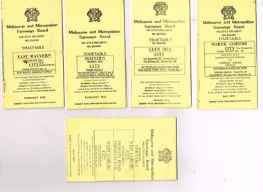
Ephemera - Timetable/s, Melbourne & Metropolitan Tramways Board (MMTB), "MMTB Tram Timetables", 1975
Set of 9 MMTB Tram timetables, folded sheets, generally 10 sections, providing timetables for specific routes, day of week giving information on tram times at specific time points, route map, sections and fares and organisation address - 616 Little Collins St. Melbourne. All printed on yellow paper unless noted otherwise. .1 - Route 3 - East Malvern 3 - Bus Route Sundays Only, Feb. 1975 .2 - Route 5, 35 - Malvern - City .3 - Route 6, 7, 36 - Glen Iris - City .4 - Route 19, 18, 20 - North Coburg - City and Sundays only - Fawkner to Gowrie, Upfield - May 1975 .5 - Route 55, 56, 68 - West Coburg - City - Domain Road - May 1975 .6 - Route 57, 54, 60, 58 and 50 - West Maribyrnong - City - Feb. 1975 .7 - Route 64, 65, 62, 61 - East Brighton - City - June 1975 .8 - Route 66, 67 and 37 - Carnegie - City - June 1975 .9 - Route 82 - Footscray - Highpoint West - Moonee Ponds (Bus service Saturday afternoons and Sundays - November 1975. See Reg Item 2886 for a tramway check ticket for use on the Upfield line.trams, tramways, mmtb, timetables, melbourne, fares, upfield, bus replacement, route 3, route 5, route 6, route 7, route 18, route 19, route 20, route 35, route 36, route 37, route 50, route 54, route 55, route 56, route 57, route 58, route 60, route 61, route 62, route 64, route 65, route 66, route 67, route 68, route 82 -
 Melbourne Tram Museum
Slide - Set of 7, Keith Caldwell, 11/03/1962 12:00:00 AM
Set of 7 Agfa Colour slides, cardboard mounts, by Keith Caldwell dated 11.3.1962 of the transfer of cars from Footscray to the "Main System" the day after the system was closed. See Keith Kings history of Footscray notes. All trams running trolley wheels. .1 - Footscray depot cars X1 463, X2 678, X1 460 and X1 466 in Gordon St, about to turn into River Street. .2 - X2 678 turning from Nicholson St into Irving St. Footscray with the Rockmans Store in the background. This store was later demolished for the Ring Road. Also is J. Boltons Chemist shop advertising Kodak film and another shop advertising Darrell Lea Chocolates, Peters Icecream and ? Lopes fruit shop. .3 - X1 460 at same location. .4 - X2 678 crossing Maribyrnong River Bridge - note the person crouching down on the south side of the bridge behind the tram. .5 - X1 460 in Rosamond Road, just before the curve onto Williamson Rd. This site became the Bunnings site. The tram has a modified 21E truck. .6 - X2 468 as above with part of the curve in the view. Has an advertisement for Bon Stores of Hopkins St Footscray. .7 - X2 678 at ditto..1 - in ink - "Farewell Footscray" Sun 11.3.1962 - Footscray Depot cars departing areas en route to Main system." .2 - .7 all have "Footscray Sun 11.3.62"trams, tramways, footscray, closure, maribyrnong, gordon st, river st, irving st, maribyrnong river, bridges, x1 class, x2 class, rosamond rd, 21e trucks, tram 463, tram 678, tram 460, tram 466 -
 Melbourne Tram Museum
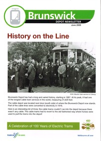
Newsletter, Yarra Trams, Century of Electric Trams, Jun. 2006
Set of 8 newsletters issued June 2006 for each tram depot, featuring a historical overview of the depot based around the "Century of Electric Trams". Front page has a historic photo of the depot or nearby, a message from the manager, thanks to Good Friday appeals, Anzac Day report, note about safety and some personnel notes for the depot itself.\ .1 - Brunswick - - opening photo of the Coburg line 1916 with a note about the cable trams. .2 - Camberwell - history at the junction - Camberwell Junction 1954 and a note on HTT. .3 - Essendon - photo of staff and officers (not in uniform) out the front of the depot - post WW1 .4 - East Preston - photo of 1000 outside depot - brand new, with notes on St Georges Road and cable. .5 - Glenhuntly - History on the line - opening of the Glenhuntly Esternwick in 1913 and Point Ormond. .6 - Kew - photo of the Barkers Road cutting 1965 .7 - Malvern - opening photo of 1910. .8 - Southbank - photo of 376 at the old South Melbourne depot while being built. List of people photographed or noted shown in Key Associations - where surname given. Some photo captions and notes only have the first name. Second copy of each item added 11-3-2018 from donation of Hugh Waldron.trams, tramways, yarra trams, 100 years of electric trams, centenary, brunswick, camberwell, essendon, east preston, glenhuntly, kew, malvern, southbank -
 Melbourne Tram Museum
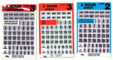
Ephemera - Ticket/s, Metropolitan Transit Authority (MTA), Set of four Scratch type tickets, late 1980's of early 1990's
Set of four Scratch type tickets, with black printing and areas where a person could scratch out the month and day of the month areas to validate the ticket. Has the number on the base of the ticket. .1 - 2 hour concession zone 3, for sale in a pack of 5 only, has been scratched for June only - ticket No. C00515659. .2 - 2 hour adult, zone 3, has not been scratched or used - SA6849 .3 - 3 hour adult, zone 2, has been scratched for Sept 11, 4 o'clock - C00253703 - second copy added added 20/2/2017 - scratched for 9am, 27/6 - D00099852. .4 - 3 hour concession for zone 2, has been scratched for 9 Sept, 5pm - C00661363 - added 29/10/2016 .5 - 3 hours Zone 1 + 2 from a pack of 5, No. C00161838, scratched for Feb. 24, 6pm - add3d 24/9/2017. On the rear are the conditions of travel for both types of tickets with information about the ticket type, The Met logos, Transport Information and Transit Patrol telephone numbers. Two different types of logos. See also Reg Item Nos. 574, 1069 and 1161 and 4624 for other examples.trams, tramways, the met, scratch tickets -
 Marysville & District Historical Society
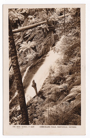
Postcard (item) - Black and white postcard, Rose Stereograph Company, Cumberland Falls, Marysville, Victoria, 1913-1967
A postcard in a series produced by the Rose Stereograph Company in Victoria, Australia as a souvenir of Marysville.A black and white photograph of the Cumberland Falls which are in Cambarville. These falls are located on the Marysville-Wood's Point Road. Cambarville is notable for its giant mountain ash (Eucalyptus regnans) trees within the Cumberland Memorial Scenic Reserve, and relics from former sawmills and gold mining. The Big Culvert is located nearby on the Marysville - Woods Point Road, which was historically part of the Yarra Track. Cambarville was established as a timber mill town in the 1940s. Timber mill owners A Cameron and FJ Barton named Cambarville. They established the mill to salvage timber from trees destroyed in the 1939 bushfires. Cambarville was impacted by the 2009 Black Saturday bushfires and any remaining structures were destroyed.POST CARD REAL PHOTO/ THE "ROSE" SERIES DE LUXE PRODUCED IN AUSTRALIA PUBLISHED BY THE ROSE STEREOGRAPHS/ Armadale, Victoria. "Tyrone"/ Buxton/ via Alexandra/ 5-1-54 Dear Auntie/ Just a card to let you know everything is/ all right, the weather just beautiful it could not/ be better. We saw Em May the other day they seem/ to be having a great time they looked good-oh./ We have not been out the last two or three days/ we are having a good rest a lot of our crowd/ have gone home so I suppose there will be a new/ lot coming. We held a cricket match between our/ house & Glasgow we beat them & they supplied/ us with a couple boxes of chocolates but it was good en-/ joyment. I think this is all hoping all at home are well/ with love Myrtle.cumberland falls, cambarville, marysville, victoria, waterfalls, p. 2328, rose series postcard, postcard, souvenir, mountain ash, mining, timber mills, big culvert, yarra track, a cameron, fj barton, black saturday bushfires, 1939 bushfires, eucalyptus regnans -
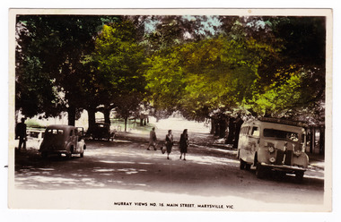 Marysville & District Historical Society
Postcard (Item) - Colour tinted postcard, Murray Views, Murray Views No. 16. Main Street, Marysville, Vic, c1940s
A colour tinted photograph of Murchison Street in Marysville in Victoria.A colour tinted photograph of the main street in Marysville in Victoria. This is now known as Murchison Street. This postcard was produced by Murray Views in Gympie in Queensland as a souvenir of Marysville.POST CARD STAMP REAL PHOTOGRAPH PRODUCED IN/ AUSTRALIA BY MURRAY VIEWS, GYMPIE, Q. Tuesday 16th/ Mount Kitchener House/ Marysville Dear Bill & Fran,/ Just a card hoping to find all well./ It is very cold night & mornings up here, only/ had a wet day though. The meals are very good/ here. I'm sure we shall both be pounds heavier./ Been fun 50th to be here, coming & going all the time./ We've been a few trips & for nice walks, some/ very stiff climbing. We are leaving here on/ Saturday morning & going to our friends at/ Heronswood for 2 or 3 days. Have you heard any/ thing of Bert's affair yet. We have been watching/ the papers. No more for now. Love to all./ Best wishes & love from us both - Bess. xoxmurchison street, marysville, victoria, murray views pty ltd, murray views no. 16., postcard, souvenir