Showing 131 items
matching east walk
-
 City of Ballarat Libraries
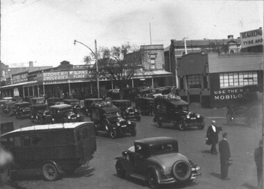
Photograph - Card Box Photographs, Funeral Procession, Ballarat circa 1931
The procession passes the south west corner of Mair and Armstong Street North. This was a double funeral for two boys who drowned in Sebastopol. Funeral Director Hugh Evans Snr walks before the hearses. Businesses in the background include Robert Ritches Grocer, the Plough & Harrow Hotel and an advertisement for Beaurepaire Mobilo.h. evans & son, hugh evans snr, funeral procession, advertising, building, mair street, armstrong street north, robert ritches grocer, plough & harrow hotel, beaurepaire mobilo, commerical, vehicle, ballarat, sebastopol -
 City of Ballarat Libraries
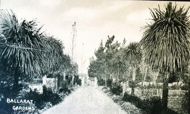
Postcard - Card Box Photographs, Palm Walk, Ballarat Botanic Gardens circa 1900
Garden path edged with palms in the Ballarat Botanic Gardens.ballarat botanic gardens, public, landscape -
 Bialik College
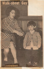
Newspaper Clipping, "Walk-about Guy", The Sun, 14 August 1969, 1969
Newspaper article "Walk-about Guy", published in The Sun, 14 August 1969.shakespeare grove, kindergarten, elc, early learning centre -
 Kew Historical Society Inc
Journal, Kewriosity : May 1985
The Armistice and our men come home - a personal memory of Kew by Bill Stent / Bill Stent p1. Community Notices [Auxiliaries; Clubs and societies; General; Politics; Religious notices; Support groups] / p2&16. Update: Notes from Council - Consultation and the decision making process / Cr Robin Saunders [Mayor of Kew] p3. Baby safety bassinet loan scheme / p4. Read this! [incinerators] / p4. Traffic management / p4. Did you know? [Kew Library - Local history, Genealogy] / p4. Kindergarten extended hours / p4. Kew jobs for women [Kew Councillors; Kew Council officers] / p5. The Churches of Kew invite you to celebrate Victoria's 150th anniversary at an Ecumenical Service / p6. Leaves and more leaves [incinerators] / p6. Join the Kew Citizens' Band Supporters Club / p6. Kew Citizens' Band in concert / p6. East Kew Shopping Centre: Good guide to easy shopping [Overview, Map, Advertisements] / p7-10. Youth Page [Youth Theatre Concept; New Youth Centre; The Parsonage - Holy Trinity Church] / p11. Football: Kew records two wins / p12. Library News / p12. Flight of fantasy [Kew/Deepdene Artists' Co-operative] / p12. What is the Kew Community Action Group? / p13. Would you like to help? [Kew Community House] / p13. Family Day Care in Kew / p13. Adult literacy in Kew / p13. Kew Community House [Open Day, Garden tools needed, City walks, Committee meetings, Kew kids 'n Kritters] / p14. Interchange needs you! [disability support] / p14. This Kewriosity is being delivered to you by - Kew Primary School / p15. May School Holiday Programs [Playcentre; Kew Traffic School; Mobile new games trailer] / p15.Kewriosity was a local newsletter combining Kew Council and community news. It was published between November 1983 and June 1994, replacing an earlier Kewriosity [broad] Sheet (1979-84). In producing Kewriosity, Council aimed to provide a range of interesting and informative articles covering its deliberations and decision making, together with items of general interest and importance to the Kew community and information not generally available through daily media outlets.non-fictionThe Armistice and our men come home - a personal memory of Kew by Bill Stent / Bill Stent p1. Community Notices [Auxiliaries; Clubs and societies; General; Politics; Religious notices; Support groups] / p2&16. Update: Notes from Council - Consultation and the decision making process / Cr Robin Saunders [Mayor of Kew] p3. Baby safety bassinet loan scheme / p4. Read this! [incinerators] / p4. Traffic management / p4. Did you know? [Kew Library - Local history, Genealogy] / p4. Kindergarten extended hours / p4. Kew jobs for women [Kew Councillors; Kew Council officers] / p5. The Churches of Kew invite you to celebrate Victoria's 150th anniversary at an Ecumenical Service / p6. Leaves and more leaves [incinerators] / p6. Join the Kew Citizens' Band Supporters Club / p6. Kew Citizens' Band in concert / p6. East Kew Shopping Centre: Good guide to easy shopping [Overview, Map, Advertisements] / p7-10. Youth Page [Youth Theatre Concept; New Youth Centre; The Parsonage - Holy Trinity Church] / p11. Football: Kew records two wins / p12. Library News / p12. Flight of fantasy [Kew/Deepdene Artists' Co-operative] / p12. What is the Kew Community Action Group? / p13. Would you like to help? [Kew Community House] / p13. Family Day Care in Kew / p13. Adult literacy in Kew / p13. Kew Community House [Open Day, Garden tools needed, City walks, Committee meetings, Kew kids 'n Kritters] / p14. Interchange needs you! [disability support] / p14. This Kewriosity is being delivered to you by - Kew Primary School / p15. May School Holiday Programs [Playcentre; Kew Traffic School; Mobile new games trailer] / p15. publications -- city of kew (vic.), kewriosity, council newsletters, community newsletters -
 Kew Historical Society Inc
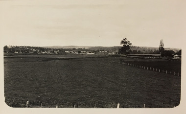
Photograph - Bruthen to Swan Reach, 1926
Henry Beater Christian (1886-1962) , was a descendant of one of the earliest settler families in Kew. Employed at the Kew Asylum as a 'public servant', he was a skilled amateur photographer, photographing numerous scenes in Kew and on his travels around Victoria. The majority of his photographs date from 1916 to 1929. His finest photographs are housed in two photograph albums. Digital copy of a photograph from page 31 of the 47-page photograph album containing 261 gelatinous silver images, loaned by Diane Washfold with permission given to digitise and hold a copy in our collection. John Chapman has written in 'Bushwalking Clubs - A Brief History', about the establishment in Victoria of the first bushwalking club in 1888, and the popularisation of bushwalking during the interwar period. Henry Christian's 'walks' appear to have been undertaken solely or with a companion/s. This black and white photo is part of a group of six photos taken on an 18 kilometre walking trip between Bruthen and Swan Reach in East Gippsland in 1926. The route of the walk followed the Tambo River."BRUTHEN TO SWAN REACH 1926"henry beater christian (1886-1962), landscape photography, christian-washfold collection, photograph albums, bushwalking, bruthen, swan reach, tambo river, east gippsland -
 Kew Historical Society Inc
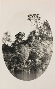
Photograph - Tambo River, 1926
Henry Beater Christian (1886-1962) , was a descendant of one of the earliest settler families in Kew. Employed at the Kew Asylum as a 'public servant', he was a skilled amateur photographer, photographing numerous scenes in Kew and on his travels around Victoria. The majority of his photographs date from 1916 to 1929. His finest photographs are housed in two photograph albums. Digital copy of a photograph from page 31 of the 47-page photograph album containing 261 gelatinous silver images, loaned by Diane Washfold with permission given to digitise and hold a copy in our collection. John Chapman has written in 'Bushwalking Clubs - A Brief History', about the establishment in Victoria of the first bushwalking club in 1888, and the popularisation of bushwalking during the interwar period. Henry Christian's 'walks' appear to have been undertaken solely or with a companion/s. This black and white photo is part of a group of six photos taken on an 18 kilometre walking trip between Bruthen and Swan Reach in East Gippsland in 1926. The route of the walk followed the Tambo River. The photographer has focussed the view using an oval frame during the development process."BRUTHEN TO SWAN REACH 1926"henry beater christian (1886-1962), landscape photography, christian-washfold collection, photograph albums, bushwalking, bruthen, swan reach, tambo river, east gippsland -
 Kew Historical Society Inc
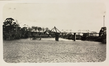
Photograph - Bridge over the Tambo River, 1926
Henry Beater Christian (1886-1962) , was a descendant of one of the earliest settler families in Kew. Employed at the Kew Asylum as a 'public servant', he was a skilled amateur photographer, photographing numerous scenes in Kew and on his travels around Victoria. The majority of his photographs date from 1916 to 1929. His finest photographs are housed in two photograph albums. Digital copy of a photograph from page 31 of the 47-page photograph album containing 261 gelatinous silver images, loaned by Diane Washfold with permission given to digitise and hold a copy in our collection. John Chapman has written in 'Bushwalking Clubs - A Brief History', about the establishment in Victoria of the first bushwalking club in 1888, and the popularisation of bushwalking during the interwar period. Henry Christian's 'walks' appear to have been undertaken solely or with a companion/s. This black and white photo is part of a group of six photos taken on an 18 kilometre walking trip between Bruthen and Swan Reach in East Gippsland in 1926. The route of the walk followed the Tambo River. The photographer has focussed the view on a ruined bridge, presumably caused by a flood, crossing the river. Sections of the left hand pier and span can be seen in the river."BRUTHEN TO SWAN REACH 1926"henry beater christian (1886-1962), landscape photography, christian-washfold collection, photograph albums, bushwalking, bruthen, swan reach, tambo river, east gippsland -
 Kew Historical Society Inc
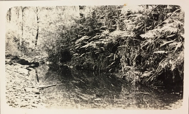
Photograph - Small creek between Bruthen and Swan Reach, 1926
Henry Beater Christian (1886-1962) , was a descendant of one of the earliest settler families in Kew. Employed at the Kew Asylum as a 'public servant', he was a skilled amateur photographer, photographing numerous scenes in Kew and on his travels around Victoria. The majority of his photographs date from 1916 to 1929. His finest photographs are housed in two photograph albums. Digital copy of a photograph from page 31 of the 47-page photograph album containing 261 gelatinous silver images, loaned by Diane Washfold with permission given to digitise and hold a copy in our collection. John Chapman has written in 'Bushwalking Clubs - A Brief History', about the establishment in Victoria of the first bushwalking club in 1888, and the popularisation of bushwalking during the interwar period. Henry Christian's 'walks' appear to have been undertaken solely or with a companion/s. This black and white photo is part of a group of six photos taken on an 18 kilometre walking trip between Bruthen and Swan Reach in East Gippsland in 1926. The route of the walk followed the Tambo River. The photographer has focussed the view on a small creek between the two towns."BRUTHEN TO SWAN REACH 1926"henry beater christian (1886-1962), landscape photography, christian-washfold collection, photograph albums, bushwalking, bruthen, swan reach, tambo river, east gippsland -
 Kew Historical Society Inc
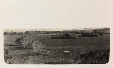
Photograph - Farmland, near or between Bruthen and Swan Reach, 1926
Henry Beater Christian (1886-1962) , was a descendant of one of the earliest settler families in Kew. Employed at the Kew Asylum as a 'public servant', he was a skilled amateur photographer, photographing numerous scenes in Kew and on his travels around Victoria. The majority of his photographs date from 1916 to 1929. His finest photographs are housed in two photograph albums. Digital copy of a photograph from page 31 of the 47-page photograph album containing 261 gelatinous silver images, loaned by Diane Washfold with permission given to digitise and hold a copy in our collection. John Chapman has written in 'Bushwalking Clubs - A Brief History', about the establishment in Victoria of the first bushwalking club in 1888, and the popularisation of bushwalking during the interwar period. Henry Christian's 'walks' appear to have been undertaken solely or with a companion/s. This black and white photo is part of a group of six photos taken on an 18 kilometre walking trip between Bruthen and Swan Reach in East Gippsland in 1926. The route of the walk followed the Tambo River. The photographer focusses the camera view on distant farmland near or between either of the two towns."BRUTHEN TO SWAN REACH 1926"henry beater christian (1886-1962), landscape photography, christian-washfold collection, photograph albums, bushwalking, bruthen, swan reach, tambo river, east gippsland -
 Kew Historical Society Inc
Photograph - Farmland, near Bruthen or Swan Reach, 1926
Henry Beater Christian (1886-1962) , was a descendant of one of the earliest settler families in Kew. Employed at the Kew Asylum as a 'public servant', he was a skilled amateur photographer, photographing numerous scenes in Kew and on his travels around Victoria. The majority of his photographs date from 1916 to 1929. His finest photographs are housed in two photograph albums. Digital copy of a photograph from page 31 of the 47-page photograph album containing 261 gelatinous silver images, loaned by Diane Washfold with permission given to digitise and hold a copy in our collection. John Chapman has written in 'Bushwalking Clubs - A Brief History', about the establishment in Victoria of the first bushwalking club in 1888, and the popularisation of bushwalking during the interwar period. Henry Christian's 'walks' appear to have been undertaken solely or with a companion/s. This black and white photo is part of a group of six photos taken on an 18 kilometre walking trip between Bruthen and Swan Reach in East Gippsland in 1926. The route of the walk followed the Tambo River. The photographer focusses the camera view on the township in the distance with farms in the foreground."BRUTHEN TO SWAN REACH 1926"henry beater christian (1886-1962), landscape photography, christian-washfold collection, photograph albums, bushwalking, bruthen, swan reach, tambo river, east gippsland -
 Kew Historical Society Inc
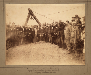
Photograph, Opening Ceremony Victoria Street Bridge: Laying of memorial stone by John Adam Esq. Mayor of Richmond, 1884
A formal group photograph of the grand opening of the Victoria Street Bridge on March 31 1884. The Argus was to report that: ‘The ceremony of laying the memorial stone of the Victoria-bridge, which connects Kew and Hawthorn with Richmond and Collingwood, was performed yesterday afternoon by the mayor of Richmond (Mr John Adam) in the presence of a large assemblage. Among the gentlemen present at yesterday’s proceedings were the mayor of Collingwood (Mr. M. Dwyer), the Mayor of Melbourne (Councillor C. Smith, M.L. A.) the mayor of Kew (Mr. Barnard), Mr. J. A. B. Koch and Mr. W. W. Shelley (ex mayors of Richmond), Mr. Joseph Bosisto, M.L.A., the Hon. L. L. Smith, Councillor De Mole (ex mayor of Kew), Mr. Jas. Lancashire and Mr. Winter (ex mayors of Ricmond), Mr. Walker (ex mayors of Collingwood), Mr. Johnson (engineer), Mr. C. Rowan, C.E. (engineer of the bridge alterations) and the town clerks of Richmond, Collingwood and Kew.’ Following the opening ceremony ‘… a ponderous steam roller was driven over the structure, with a view to test, or rather to demonstrate its stability … Most of the gentlemen present walked over the bridge, after which they were grouped by a photographer, with the memorial stone as a central feature, and several views of the scene were taken’.An original, rare silver albumen mounted and titled photograph of an important event in 19th century Melbourne.Original photograph mounted on display card of the opening of the Victoria Street Bridge. The original photograph is very faded and has been enhanced to improve the image's viewability.On the reverse of the card is an indecipherable stamp and an inscription identifying the photographers. "T. W. & C. A. McAlpine Bros, Photographers &., Campbell Parade East Richmond Melbourne March 31.1884victoria street bridge, john adam, m. dwyer, c. smith, barnard, j.a.b. koch, w.w. shelley, bridge, kew, collingwood, l.l. smith, joseph bosisto -
 Surrey Hills Historical Society Collection
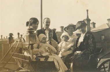
Photograph, David Miller and Lily Vipond Mair and family, c1921
David Miller (Dave) Mair (1879-1938) married Lily Vipond Deakin (1890-1945) in 1910. They had 5 children: Geoffrey David (1913-1970), Beryl (1916-1976), Gwynneth (1917-1997), Isabel Lillian (1921-1997) and Shirley Inez (1928-1968). Personal communication from Laurie Newton, Beryl's daughter: Dave and Lily initially lived in East Melbourne after they married. Dave walked across the gardens to work at the MCG. He never drove or owned a car. Geoffrey, Beryl and Gwynneth were born in East Melbourne. They subsequently moved to Louise Avenue, Mont Albert and Isabel may have been born while they were there. Later they purchased 20 Barton Street, Mont Albert. Electoral roll details: 1919 68 Park Street, Hawthorn 1922 24 Louise Avenue, Mont Albert 1924 20 Barton Street, Mont Albert So, Shirley would have been born while they were at Barton Street. On the basis of these dates, this may have been taken in Hawthorn. Identification of 'Grannie': If this is Lily's mother her name is Janet Deakin (nee Longmore - 1851-1939). If it is Dave's mother her name is Isabel Brown (1855-1944). The other woman is identified as May Little, who helped in the house. Dave Mair was a very keen sportsman. A sepia photo of a well-dressed family in and beside a buggy. The group is comprised of a man, 3 women and 3 children. The chimneys of Victorian or perhaps Edwardian houses are in the background.On rear: "Grannie Dad Mum / Beryl Geoff Isabel" (in hand 1 and blue biro) "on left Isabel on knee" (in a different hand in black biro) "May Little (Helped in / House" (in hand 1 in blue biro). On the basis of inscriptions in family autograph books, the first and third inscriptions look to have been written by Beryl Mair.david miller mair, dave mair, lily vipond mair, lily vipond deakin, geoffrey david mair, beryl mair, gwynneth mair, isabel lillian mair, janet deakin, janet longmore, isabel brown, isabel mair, horse-drawn vehicles, children, may little -
 Surrey Hills Historical Society Collection
Photograph - Photograph, Sepia, c1921
David Miller (Dave) Mair (1879-1938) married Lily Vipond Deakin (1890-1945) in 1910. They had 5 children: Geoffrey David (1913-1970), Beryl (1916-1976), Gwynneth (1917-1997), Isabel Lillian (1921-1997) and Shirley Inez (1928-1968). Personal communication from Laurie Newton, Beryl's daughter: Dave and Lily initially lived in East Melbourne after they married. Dave walked across the gardens to work at the MCG. He never drove or owned a car. Geoffrey, Beryl and Gwynneth were born in East Melbourne. They subsequently moved to Louise Avenue, Mont Albert and Isabel may have been born while they were there. Later they purchased 20 Barton Street, Mont Albert. Shirley was born after they moved to Barton Street. Electoral roll details: 1919 68 Park Street, Hawthorn 1922 24 Louise Avenue, Mont Albert 1924 20 Barton Street, Mont Albert Dave Mair was a very keen sportsman. This is part of a large donation of material from the Deakin, Mair and Young families. The Mair family were long term residents in the area with strong social and business connections to the Surrey Hills community.A sepia photo of a man, a women, 2 children and a baby seated in front of a paling fence. The man is balding with a moustache. Children's faces are lowered as if avoiding looking at the sun.On rear: "Dad Beryl Geoff / Mum Isabel" in blue biro. Thought to be Beryl Mair's handwriting.david miller mair, dave mair, lily vipond deakin, lily vipond mair, geoffrey mair, beryl mair, isabel mair gwynneth mair, toddlers, family portraits, 1920s -
 Surrey Hills Historical Society Collection
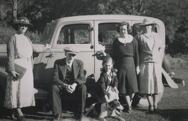
Photograph, David Miller and Lily Vipond Mair and family and friends on outing, c1932
David Miller (Dave) Mair (1879-1938) married Lily Vipond Deakin (1890-1945) in 1910. They had 5 children: Geoffrey David (1913-1970), Beryl (1916-1976), Gwynneth (1917-1997), Isabel Lillian (1921-1997) and Shirley Inez (1928-1968). Personal communication from Laurie Newton, Beryl's daughter: Dave and Lily initially lived in East Melbourne after they married. Dave walked across the gardens to work at the MCG. He never drove or owned a car. Geoffrey, Beryl and Gwynneth were born in East Melbourne. They subsequently moved to Louise Avenue, Mont Albert and Isabel may have been born while they were there. Later they purchased 20 Barton Street, Mont Albert. Shirley was born after they moved to Barton Street. Electoral roll details: 1919 68 Park Street, Hawthorn 1922 24 Louise Avenue, Mont Albert 1924 20 Barton Street, Mont Albert Dave Mair was a very keen sportsman. The woman named as Mattie was Martha Dunham Brooks b1892, Camberwell. She was the daughter of Arthur 'Empire' Brooks and his wife Mary Jane Wilson who lived at 21 York Street. They also had twin boys: Thomas Moffat Brooks – b. 1899, Surrey Hills; d. 1906 and Edwin Dunham Wilson Brooks – b. 1899, Surrey Hills; d. 1971 Heidelberg. The donor remembered the later as a builder of 11 York Street. Martha m. Clifford Ernest Cairns in 1935. Mattie Cairns was the donor's godmother. This is part of a large donation of material from the Deakin, Mair and Young families. This is part of a large donation of material from the Deakin, Mair and Young families all of which had connections with Surrey Hills / Mont Albert.A black & white photo of a man, a women, 2 women, a girl and a young lady beside a car in a country setting. The girl is bending to pat a dog.On rear: "Mum Dad Mair / Shirl Isabel Mattie / Digger - Cliff Cairns / Dog" in blue biro. Thought to be Beryl Mair's handwriting. "LILY" and "DAVE" in lead pencil above Mum and Dad. Photographer's stamp "653" in blue ink.dave mair, david miller mair, lilly vipond deakin, lily vipond mair, shirley inez mair, isabel lillian mair, mattie brooks, martha dunham brooks, cars -
 Surrey Hills Historical Society Collection
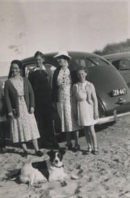
Photograph, Lily Vipond Mair with family and friends at the beach, c1936
David Miller (Dave) Mair (1879-1938) married Lily Vipond Deakin (1890-1945) in 1910. They had 5 children: Geoffrey David (1913-1970), Beryl (1916-1976), Gwynneth (1917-1997), Isabel Lillian (1921-1997) and Shirley Inez (1928-1968). Personal communication from Laurie Newton, Beryl's daughter: Dave and Beryl initially lived in East Melbourne after they married. Dave walked across the gardens to work at the MCG. He never drove or owned a car. Geoffrey, Beryl and Gwynneth were born in East Melbourne. They subsequently moved to Louise Avenue, Mont Albert and Isabel may have been born while they were there. Later they purchased 20 Barton Street, Mont Albert. Shirley was born after they moved to Barton Street. Electoral roll details: 1919 68 Park Street, Hawthorn 1922 24 Louise Avenue, Mont Albert 1924 20 Barton Street, Mont Albert Dave Mair was a very keen sportsman. The woman named as Mattie was Martha Dunham Brooks b1892, Camberwell. She was the daughter of Arthur 'Empire' Brooks and his wife Mary Jane Wilson who lived at 21 York Street. They also had twin boys: Thomas Moffat Brooks – b. 1899, Surrey Hills; d. 1906 and Edwin Dunham Wilson Brooks – b. 1899, Surrey Hills; d. 1971 Heidelberg. The donor remembered the later as a builder of 11 York Street. Martha m. Clifford Ernest Cairns in 1935. Mattie Cairns was the donor's godmother. This is part of a large donation of material from the Deakin, Mair and Young families. This is part of a large donation of material from the Deakin, Mair and Young families all of which had connections with Surrey Hills / Mont Albert. Mattie Brooks' father was a significant figure in early Surrey Hills.A black & white photo of 2 women, a girl and a lad beside a car on the sand at the beach.On rear: "Mum Mattie / Shirl / Digger (Cliff Cairns / Dog" in blue biro. "MATTIE BROOKS / LAD UNKNOWN" Thought to be Beryl Mair's handwriting. Photographer's stamp "653" in blue ink.beach, lily vipond mair, lilly vipond deakin, mattie brooks, martha dunham brooks, mattie cairns, martha dunham carins -
 Surrey Hills Historical Society Collection
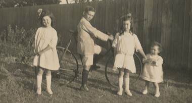
Photograph, Four Mair children in the backyard, c1922
David Miller (Dave) Mair (1879-1938) married Lily Vipond Deakin (1890-1945) in 1910. They had 5 children: Geoffrey David (1913-1970), Beryl (1916-1976), Gwynneth (1917-1997), Isabel Lillian (1921-1997) and Shirley Inez (1928-1968). Personal communication from Laurie Newton, Beryl's daughter: Dave and Lily initially lived in East Melbourne after they married. Dave walked across the gardens to work at the MCG. He never drove or owned a car. Geoffrey, Beryl and Gwynneth were born in East Melbourne. They subsequently moved to Louise Avenue, Mont Albert and Isabel may have been born while they were there. Later they purchased 20 Barton Street, Mont Albert. Shirley was born after they moved to Barton Street. Electoral roll details: 1919 68 Park Street, Hawthorn 1922 24 Louise Avenue, Mont Albert 1924 20 Barton Street, Mont Albert Dave Mair was a very keen sportsman. This is part of a large donation of material from the Deakin, Mair and Young families. The Deakin, Mair and Young families had many connections with Mont Albert and Surrey Hills.A sepia photo of 4 well-dressed children, a boy and 3 girls, one a toddler, in a back yard. The boy is astride a bicycle and the girls stand either side. Behind them is a high paling fence.On rear: "Gwen Geoff Beryl Isabel" in blue biro. Thought to be Beryl Mair's handwriting. Photographic processing stamp in blue "54".david miller mair, dave mair, lily vipond deakin, lily vipond mair, geoffrey mair, beryl mair, isabel mair gwynneth mair, children, back yards, bicycles -
 Surrey Hills Historical Society Collection
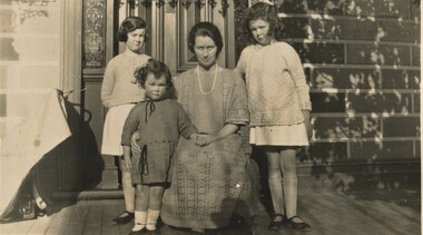
Photograph, Lily Mair and 3 daughters, c1924
David Miller (Dave) Mair (1879-1938) married Lily Vipond Deakin (1890-1945) in 1910. They had 5 children: Geoffrey David (1913-1970), Beryl (1916-1976), Gwynneth (1917-1997), Isabel Lillian (1921-1997) and Shirley Inez (1928-1968). Personal communication from Laurie Newton, Beryl's daughter: Dave and Lily initially lived in East Melbourne after they married. Dave walked across the gardens to work at the MCG. He never drove or owned a car. Geoffrey, Beryl and Gwynneth were born in East Melbourne. They subsequently moved to Louise Avenue, Mont Albert and Isabel may have been born while they were there. Later they purchased 20 Barton Street, Mont Albert. Shirley was born after they moved to Barton Street. Electoral roll details: 1919 68 Park Street, Hawthorn 1922 24 Louise Avenue, Mont Albert 1924 20 Barton Street, Mont Albert Dave Mair was a very keen sportsman. This is part of a large donation of material from the Deakin, Mair and Young families. The Deakin, Mair and Young families had many connections with Mont Albert and Surrey Hills.A sepia photo of a woman seated on a veranda with 3 girls. Part of the facade of the house can be seen behind them. The veranda is timber. The door has acid-etched feature windows either side of it. The front is block-fronted and looks to be picked out in 2 paint colours. There are shadows of foliage and from lacework detail on the veranda cast over one side and the top pf the photo. The shadow of the photographer's hat can be seen on the bottom edge.On rear: "L-R" (in lead pencil) Beryl Isabel Mum / Gwen at Barton St" in blue biro. Thought to be Beryl Mair's handwriting. Number 39 in lead pencil.barton street, children, lily vipond deakin, lily vipond mair, beryl mair, isabel mair,, gwynneth mair -
 Surrey Hills Historical Society Collection
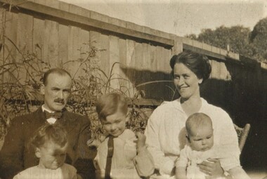
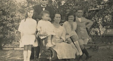
Photograph, Dave and Lily Mair and children, c1923, c1923
David Miller (Dave) Mair (1879-1938) married Lily Vipond Deakin (1890-1945) in 1910. They had 5 children: Geoffrey David (1913-1970), Beryl (1916-1976), Gwynneth (1917-1997), Isabel Lillian (1921-1997) and Shirley Inez (1928-1968). Personal communication from Laurie Newton, Beryl's daughter: Dave and Lily initially lived in East Melbourne after they married. Dave walked across the gardens to work at the MCG. He never drove or owned a car. Geoffrey, Beryl and Gwynneth were born in East Melbourne. They subsequently moved to Louise Avenue, Mont Albert and Isabel may have been born while they were there. Later they purchased 20 Barton Street, Mont Albert. Shirley was born after they moved to Barton Street. Electoral roll details: 1919 68 Park Street, Hawthorn 1922 24 Louise Avenue, Mont Albert 1924 20 Barton Street, Mont Albert Dave Mair was a very keen sportsman. This is part of a large donation of material from the Deakin, Mair and Young families. The Deakin, Mair and Young families had many connections with Mont Albert and Surrey Hills.A sepia photo of a family posed informally in a garden. The woman is seated on a cane chair holding the youngest child with one girl standing to her left and a girl and boy standing to her right. The man is standing behind her with only his face captured in the photo. The infant and the girl to the right have moved and their faces are blurred. The house in the background is of block-front construction with simple fretwork to the veranda.On rear: "Beryl Dad Isabel Mum / Gwen Geoff / at Louise Avenue / Mont Abert" in blue biro. Thought to be Beryl Mair's handwriting. Photographic processing stamp in blue ink "54 P"barton street, children, lily vipond deakin, lily vipond mair, beryl mair, isabel mair,, gwynneth mair -
 Surrey Hills Historical Society Collection
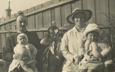
Photograph, Dave and Lily Mair and 3 children, c1918, c1918
David Miller (Dave) Mair (1879-1938) married Lily Vipond Deakin (1890-1945) in 1910. They had 5 children: Geoffrey David (1913-1970), Beryl (1916-1976), Gwynneth (1917-1997), Isabel Lillian (1921-1997) and Shirley Inez (1928-1968). Personal communication from Laurie Newton, Beryl's daughter: Dave and Lily initially lived in East Melbourne after they married. Dave walked across the gardens to work at the MCG. He never drove or owned a car. Geoffrey, Beryl and Gwynneth were born in East Melbourne. They subsequently moved to Louise Avenue, Mont Albert and Isabel may have been born while they were there. Later they purchased 20 Barton Street, Mont Albert. Shirley was born after they moved to Barton Street. Electoral roll details: 1919 1922 24 Louise Avenue, Mont Albert 1924 20 Barton Street, Mont Albert Dave Mair was a very keen sportsman. This is part of a large donation of material from the Deakin, Mair and Young families. The Deakin, Mair and Young families had many connections with Mont Albert and Surrey Hills.A post card type sepia photo of a family posed informally in a garden. Both the woman and the man are seated with children on their knees. A boy stands between them. In the background is a high paling fence beyond which 2 chimneys of adjacent properties can be seen. The woman is wearing a large brimmed hat so that half her face is in shadow. The man has a moustache and a receding hairline. All the faces are part in shadow.On rear: "MAIR / Dad Gwen Geoff / Mum Beryl" in blue biro. Thought to be Beryl Mair's handwriting. gwynneth mair, david miller mair, dave mair, lily vipond mair, lily vipond deakin, georffrey mair, gwynneth mair, beryl mair, hawthorn, children, families -
 Surrey Hills Historical Society Collection
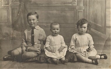
Photograph, Godfrey E Roberts, Geoffrey, Gwynneth and Beryl Mair, c1917, c1917
David Miller (Dave) Mair (1879-1938) married Lily Vipond Deakin (1890-1945) in 1910. They had 5 children: Geoffrey David (1913-1970), Beryl (1916-1976), Gwynneth (1917-1997), Isabel Lillian (1921-1997) and Shirley Inez (1928-1968). Personal communication from Laurie Newton, Beryl's daughter: Dave andLily initially lived in East Melbourne after they married. Dave walked across the gardens to work at the MCG. He never drove or owned a car. Geoffrey, Beryl and Gwynneth were born in East Melbourne. They subsequently moved to Louise Avenue, Mont Albert and Isabel may have been born while they were there. Later they purchased 20 Barton Street, Mont Albert. Shirley was born after they moved to Barton Street. Electoral roll details: 1919 1922 24 Louise Avenue, Mont Albert 1924 20 Barton Street, Mont Albert Dave Mair was a very keen sportsman. This is part of a large donation of material from the Deakin, Mair and Young families. The Deakin, Mair and Young families had many connections with Mont Albert and Surrey Hills.A post card type sepia photo of a 3 children posed formally in a studio. All are seated on cushions on the floor with a backdrop imitating formal panelling with drapery and a door. The boy on the left is wearing shorts, shirt and tie and is smiling. The infant in the middle is in a dress, without shoes and is sitting unaided. The girl on the right looks serious and may be holding something in her left hand as it is not fully visible.On rear: "Geoff Gwen Beryl" in blue biro. Thought to be Beryl Mair's handwriting. gwynneth mair, david miller mair, dave mair, lily vipond mair, lily vipond deakin, georffrey mair, gwynneth mair, beryl mair, hawthorn, children, families -
 Surrey Hills Historical Society Collection
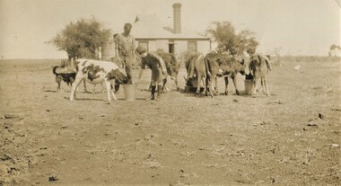
Photograph, Mair family visiting the Jarmans at Derrinallum, c1927, c1927
David Miller (Dave) Mair (1879-1938) married Lily Vipond Deakin (1890-1945) in 1910. They had 5 children: Geoffrey David (1913-1970), Beryl (1916-1976), Gwynneth (1917-1997), Isabel Lillian (1921-1997) and Shirley Inez (1928-1968). Personal communication from Laurie Newton, Beryl's daughter: Dave and Lily initially lived in East Melbourne after they married. Dave walked across the gardens to work at the MCG. He never drove or owned a car. Geoffrey, Beryl and Gwynneth were born in East Melbourne. They subsequently moved to Louise Avenue, Mont Albert and Isabel may have been born while they were there. Later they purchased 20 Barton Street, Mont Albert. Shirley was born after they moved to Barton Street. Electoral roll details: 1919 1922 24 Louise Avenue, Mont Albert 1924 20 Barton Street, Mont Albert Dave Mair was a very keen sportsman. This is part of a large donation of material from the Deakin, Mair and Young families. The Deakin, Mair and Young families had many connections with Mont Albert and Surrey Hills.A sepia photo of a girl bending towards a calf feeding from a bucket with a man overlooking. There are 6 calves altogether feeding from a small trough and 2 buckets. In the background is an Edwardian timber house with a brick chimney and a corrugated iron roof. There is a centrally positioned (?) rear door with windows either side. There is a tank to the left of the house, which is enclosed within a post and wire fence. The surroundings look very bare.On the rear in black ink: "Feeding time for the / calves at Derrinallum / B Mair / 20 Barton St / Surrey Hills / E10." Writing may be that of Lily Mair. In blue biro: " Beryl Gwen ? Mr Jarman" Thought to be Beryl Mair's handwriting. Photographic process stamp "C 311" "KODAK PRINT" in black. Despite the inscription including Gwen Mair, only one child can be seen. beryl mair, derrinallum, farms, mr jarman -
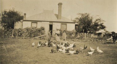 Surrey Hills Historical Society Collection
Photograph, Mair family visiting the Jarmans at Derrinallum, c1927 (2), c1927
David Miller (Dave) Mair (1879-1938) married Lily Vipond Deakin (1890-1945) in 1910. They had 5 children: Geoffrey David (1913-1970), Beryl (1916-1976), Gwynneth (1917-1997), Isabel Lillian (1921-1997) and Shirley Inez (1928-1968). Personal communication from Laurie Newton, Beryl's daughter: Dave and Beryl initially lived in East Melbourne after they married. Dave walked across the gardens to work at the MCG. He never drove or owned a car. Geoffrey, Beryl and Gwynneth were born in East Melbourne. They subsequently moved to Louise Avenue, Mont Albert and Isabel may have been born while they were there. Later they purchased 20 Barton Street, Mont Albert. Shirley was born after they moved to Barton Street. Electoral roll details: 1919 1922 24 Louise Avenue, Mont Albert 1924 20 Barton Street, Mont Albert Dave Mair was a very keen sportsman. This is part of a large donation of material from the Deakin, Mair and Young families. The Deakin, Mair and Young families had many connections with Mont Albert and Surrey Hills.A sepia photo of a woman and 2 girls standing behind about 30 fowls. The woman is holding a dish. In the background is an Edwardian (?) timber house with 2 brick chimneys and a corrugated iron roof, the ridge of which has a narrow peak with simple finials and ridge tiles. There is a centrally positioned (?) rear door with windows either side. There is a tank to the left of the house and a veranda to the RHS. The house is enclosed within a post and wire fence with a wire gate in line with the door. The fence appears to be lined with large rocks and behind the fence is garden plants of which cannot be identified. A few cows are to the right off-side.On the rear in black ink: "Feeding the fowls at / Derrinallum / Beryl Mair / 20 Barton Street / Surrey Hills / E10." Writing may be that of Lily Mair. In blue biro: " Gwen Beryl Mrs Jarman / Beauty (Jersey cow)" Thought to be Beryl Mair's handwriting. "KODAK PRINT" in black. beryl mair, gwen mair, farms, derrinallum, mrs jarman -
 Surrey Hills Historical Society Collection
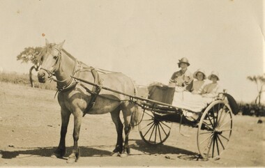
Photograph, Gwen and Beryl Mair and Mrs Jarman in a jinker, Derrinallum, c1927, c1927
David Miller (Dave) Mair (1879-1938) married Lily Vipond Deakin (1890-1945) in 1910. They had 5 children: Geoffrey David (1913-1970), Beryl (1916-1976), Gwynneth (1917-1997), Isabel Lillian (1921-1997) and Shirley Inez (1928-1968). Personal communication from Laurie Newton, Beryl's daughter: Dave and Lily initially lived in East Melbourne after they married. Dave walked across the gardens to work at the MCG. He never drove or owned a car. Geoffrey, Beryl and Gwynneth were born in East Melbourne. They subsequently moved to Louise Avenue, Mont Albert and Isabel may have been born while they were there. Later they purchased 20 Barton Street, Mont Albert. Shirley was born after they moved to Barton Street. Electoral roll details: 1919 1922 24 Louise Avenue, Mont Albert 1924 20 Barton Street, Mont Albert Dave Mair was a very keen sportsman. This is part of a large donation of material from the Deakin, Mair and Young families. The Deakin, Mair and Young families had many connections with Mont Albert and Surrey Hills.A sepia photo of a woman and 2 girls in a jinker. They are all wearing brimmed hats as if going on an outing. Apart from a couple of straggly trees in the background along what may be a boundary or paddock fence, the surroundings look very bare.In blue biro: " Gwen / Beryl / Mrs Jarman / Derrinallum" Thought to be Beryl Mair's handwriting. Photographic process stamp "C 311" "KODAK PRINT" in black. beryl mair, gwen mair, mrs jarman, farms, children, horse-drawn vehicles -
 Surrey Hills Historical Society Collection
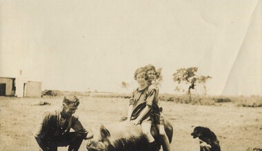
Photograph, Gwen and Beryl Mair with Mr Jarman, Derrinallum, c1927, c1927
David Miller (Dave) Mair (1879-1938) married Lily Vipond Deakin (1890-1945) in 1910. They had 5 children: Geoffrey David (1913-1970), Beryl (1916-1976), Gwynneth (1917-1997), Isabel Lillian (1921-1997) and Shirley Inez (1928-1968). Personal communication from Laurie Newton, Beryl's daughter: Dave and Lily initially lived in East Melbourne after they married. Dave walked across the gardens to work at the MCG. He never drove or owned a car. Geoffrey, Beryl and Gwynneth were born in East Melbourne. They subsequently moved to Louise Avenue, Mont Albert and Isabel may have been born while they were there. Later they purchased 20 Barton Street, Mont Albert. Shirley was born after they moved to Barton Street. Electoral roll details: 1919 1922 24 Louise Avenue, Mont Albert 1924 20 Barton Street, Mont Albert Dave Mair was a very keen sportsman. This is part of a large donation of material from the Deakin, Mair and Young families. The Deakin, Mair and Young families had many connections with Mont Albert and Surrey Hills.A sepia photo of 2 girls on the back of a pig, which is being lightly held by a man, squatting beside the animal. A cattle dog sits nearby. In the background are some straggly trees along what may be a boundary or paddock fence, apart from which the surroundings look very bare. Off to the LHS in the background is farm shedding.In black ink: "Off for a joy ride / B. Mair / 20 Barton St / SUrrey Hills / E10." - thought to be in Lily Mair's handwriting. In blue biro: " Gwen Beryl (IN FRONT in lead pencil) / Mr Jarman / Derrinallum" Thought to be Beryl Mair's handwriting. "KODAK PRINT" in black. beryl mair, gwen mair, mr jarman, farms, children, derrinallum -
 Surrey Hills Historical Society Collection
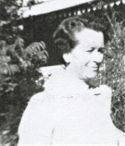
Photograph, Lily Vipond Mair, c1940, c1940
David Miller (Dave) Mair (1879-1938) married Lily Vipond Deakin (1890-1945) in 1910. They had 5 children: Geoffrey David (1913-1970), Beryl (1916-1976), Gwynneth (1917-1997), Isabel Lillian (1921-1997) and Shirley Inez (1928-1968). Personal communication from Laurie Newton, Beryl's daughter: Dave and Lily initially lived in East Melbourne after they married. Dave walked across the gardens to work at the MCG. He never drove or owned a car. Geoffrey, Beryl and Gwynneth were born in East Melbourne. They subsequently moved to Louise Avenue, Mont Albert and Isabel may have been born while they were there. Later they purchased 20 Barton Street, Mont Albert. Shirley was born after they moved to Barton Street. Electoral roll details: 1919 68 Park Street, Hawthorn 1922 24 Louise Avenue, Mont Albert 1924 20 Barton Street, Mont Albert Dave Mair was a very keen sportsman. This is part of a large donation of material from the Deakin, Mair and Young families. A black & white photocopy image of Lily Vipond Mair (nee Deakin) taken from a photo.On rear in grey lead pencil: "Lily Vipond Mair / (nee Deakin) / aged about 50 / (5.7.1890-1943)" lily vipond deakin, lily vipond mair -
 Surrey Hills Historical Society Collection
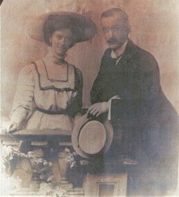
Photograph, Dave and Lily Mair, 1909, 1909
David Miller (Dave) Mair (1879-1938) married Lily Vipond Deakin (1890-1945) in 1910. They had 5 children: Geoffrey David (1913-1970), Beryl (1916-1976), Gwynneth (1917-1997), Isabel Lillian (1921-1997) and Shirley Inez (1928-1968). Personal communication from Laurie Newton, Beryl's daughter: Dave and Lily initially lived in East Melbourne after they married. Dave walked across the gardens to work at the MCG. He never drove or owned a car. Geoffrey, Beryl and Gwynneth were born in East Melbourne. They subsequently moved to Louise Avenue, Mont Albert and Isabel may have been born while they were there. Later they purchased 20 Barton Street, Mont Albert. Shirley was born after they moved to Barton Street. Electoral roll details: 1919 1922 24 Louise Avenue, Mont Albert 1924 20 Barton Street, Mont Albert Dave Mair was a very keen sportsman. This is part of a large donation of material from the Deakin, Mair and Young families. The Deakin, Mair and Young families had many connections with Mont Albert and Surrey Hills.A coloured photocopy of a couple identified as Lily Vipond Deakin and David Miller Mair. The original is a studio portrait of a couple behind a balustrade decorated with swags of flowers. She is wearing a hat with a large brim. He is holding a straw boater hat.On rear in grey lead pencil: "Lily Vipond (nee Deakin) / and Dave Millar Mair / 1909 (all underlined) / They were married / on 5.5.1910". david miller mair, dave mair, lily vipond mair, lily vipond deakin -
 Surrey Hills Historical Society Collection
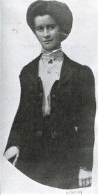
Photograph, Lily Deakin, 1909, 1909
David Miller (Dave) Mair (1879-1938) married Lily Vipond Deakin (1890-1945) in 1910. They had 5 children: Geoffrey David (1913-1970), Beryl (1916-1976), Gwynneth (1917-1997), Isabel Lillian (1921-1997) and Shirley Inez (1928-1968). Personal communication from Laurie Newton, Beryl's daughter: Dave and Lily initially lived in East Melbourne after they married. Dave walked across the gardens to work at the MCG. He never drove or owned a car. Geoffrey, Beryl and Gwynneth were born in East Melbourne. They subsequently moved to Louise Avenue, Mont Albert and Isabel may have been born while they were there. Later they purchased 20 Barton Street, Mont Albert. Shirley was born after they moved to Barton Street. Electoral roll details: 1919 1922 24 Louise Avenue, Mont Albert 1924 20 Barton Street, Mont Albert Dave Mair was a very keen sportsman. This is part of a large donation of material from the Deakin, Mair and Young families. The Deakin, Mair and Young families had many connections with Mont Albert and Surrey Hills.A black & white photocopy of a woman identified as Lily Vipond Deakin. The original appears to have been oval in shape. Her hair is swept back in a bouffant bun. She is wearing a blouse with high necked collar and a fitted jacket and waistcoat. On rear in grey lead pencil: "Lily Vipond Mair / (nee Deakin) / b: 5.7.1890 d: 1943 / wife of / David Millar Mair / they married on 5.5.1910". david miller mair, dave mair, lily vipond mair, lily vipond deakin -
 Surrey Hills Historical Society Collection
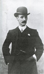
Photograph, David Miller Mair, c1909, c1909
David Miller (Dave) Mair (1879-1938) married Lily Vipond Deakin (1890-1945) in 1910. They had 5 children: Geoffrey David (1913-1970), Beryl (1916-1976), Gwynneth (1917-1997), Isabel Lillian (1921-1997) and Shirley Inez (1928-1968). Personal communication from Laurie Newton, Beryl's daughter: Dave and Lily initially lived in East Melbourne after they married. Dave walked across the gardens to work at the MCG. He never drove or owned a car. Geoffrey, Beryl and Gwynneth were born in East Melbourne. They subsequently moved to Louise Avenue, Mont Albert and Isabel may have been born while they were there. Later they purchased 20 Barton Street, Mont Albert. Shirley was born after they moved to Barton Street. Electoral roll details: 1919 1922 24 Louise Avenue, Mont Albert 1924 20 Barton Street, Mont Albert Dave Mair was a very keen sportsman. This is part of a large donation of material from the Deakin, Mair and Young families. The Deakin, Mair and Young families had many connections with Mont Albert and Surrey Hills.A black & white photocopy of a man with a moustache identified as David Miller Mair. The original is a formal portrait of him wearing a bowler hat and 3 piece suit, the jacket with flower in the buttonhole and the waistcoat with fob watch chain. He has his hands in his pockets and is looking in part profile at the camera. On rear in grey lead pencil: "David Millar Mair / 22.4.1879-16.9.1938". david miller mair, dave mair, lily vipond mair, lily vipond deakin -
 St Patrick's Old Collegians Association (SPOCA)
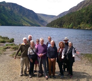
Photograph - SPOCA, Tour of Ireland
-
 St Patrick's Old Collegians Association (SPOCA)
Photograph - Buildings, SICG, Crests