Showing 106 items matching " flood levels"
-
 Wodonga & District Historical Society Inc
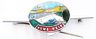
Souvenir - Tallangatta - Hume Weir Tiepin, 1980s
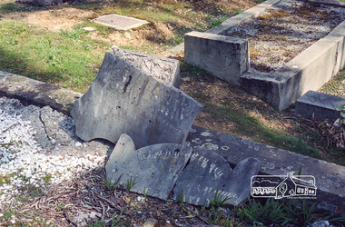
A wide range of items have been created as souvenirs to represent the Hume Weir on the Murray River. Work on Hume Dam started in 1919 and took 17 years to complete. Souvenir items have included chinaware, ashtrays, placemats and small jewellery items such as this tie pin. This tie pin was created as a souvenir for the town of Tallangatta. In the 1950s, the height of the Hume Weir wall was increased, resulting in a nine metre rise in the level of the water in Lake Hume. This necessitated the moving of most of the town of Old Tallangatta due to flooding. The transfer of the township by the State Rivers and Waters Supply Commission to a new site approximately 8 kilometres to the west was completed on 29 June 1956.This item is representative of many items commemorating the Hume Weir and the township of Tallangatta.A small metal and enamelled oval tie pin. It features and image of the Hume Weir.Around top edge in white: TALLANGATTA Around bottom edge" HUME WEIR"hume weir australia, tallangatta, tallangatta - the town that moved -
 Wodonga & District Historical Society Inc
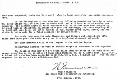
Album - Hume Reservoir Australia Album - Introduction - Part 2, Department of Public Works, N.S.W, 1927
This set of photos is from a leather bound album bearing the inscription "HUME RESERVOIR AUSTRALIA" plus 'The Rt. Hon. L. C. M. S. Amery, P. C., M .P.' all inscribed in gold. It was presented to The Rt. Hon. L. C. M. S. Amery, P. C., M. P, Secretary of State for Dominion Affairs on the occasion of his visit to the Hume Reservoir on 2nd November 1927. This album is of local and national significance as it documents the planning and development of the Hume Reservoir up to 1927. It was the largest water reservoir in the British Empire. The album records the pioneering engineering work that went into its construction.DEPARTMENT OF PUBLIC WORKS, N.S.W. (continued from previous image). have been completed, Locks Nos. 2, 4 and 6, also in South Australia, are under construction. In the description of the Hume Dam the following emendations have to be made. The total length will be 5,300 feet of which 4,258 feet will consist of an earthen embankment. The maximum depth of water conserved will be 24 feet more than originally intended with an additional allowance of 9 feet for surcharge, the total capacity will be 2,000,000 acre feet, the water surface at full supply level 44,000 acres, and provision is being made for a flood discharge of 182,000 cusecs. For handy reference, the main dimensions and figures and comparisons with other dams throughout the world are given in a tabulated statement attached. The Hume Reservoir will be the largest in the British Empire. Photographs showing the work at various stages of construction are appended. The Resident Engineer for New South Wales from the start of the work until his recent promotion to the position of Inspecting Engineer was Mr J. Keith Ross, M.A., B.Sc., A.M.Inst.C.E., who has been succeeded by Mr S.W. Jones, B.E., A.M.Inst.C.E. The Resident Engineer for Victoria is Mr A.W. Johnson, B.E. (Signed) M. Inst.C.E. Chief Engineer New South Wales Constructing Authority 27th October 1927. hume reservoir australia, river murray waters scheme -
 Wodonga & District Historical Society Inc
Album - Hume Reservoir Australia Album - Detail plan and explanation, Department of Public Works, N.S.W, 1927
This set of photos is from a leather bound album bearing the inscription "HUME RESERVOIR AUSTRALIA" plus 'The Rt. Hon. L. C. M. S. Amery, P. C., M .P.' all inscribed in gold. It was presented to The Rt. Hon. L. C. M. S. Amery, P. C., M. P, Secretary of State for Dominion Affairs on the occasion of his visit to the Hume Reservoir on 2nd November 1927. This album is of local and national significance as it documents the planning and development of the Hume Reservoir up to 1927. It was the largest water reservoir in the British Empire. The album records the pioneering engineering work that went into its construction.2. Detail Plan and Section. Starting from the New South Wales and there will be an earthen embankment 430 feet 6 inches long which is retained by the North Wing Wall. Then come the sluice section 284 feet 3 inches long, the spillway 720 feet long and the South Wing Wall, making a total length of 1,042 feet 6 inches of concrete wall. Beyond the South Wing Wall is earth embankment again to a length of 3,827 feet. The Full Supply Level is R.L.626.00 and allowance has been made for a surcharge of 9 feet. A road will run along the top of the dam at R.L.642.00. The sluice section contains seven offlets, the three nearest the north wing wall being 13 feet in diameter for hydro-electric purposes and the other four 9 feet in diameter for regulation purposes only. There are to be stony sluice gates on the upstream ends of the outlets and needle valves on the downstream ends. The shock of the discharged water will be taken by a stilling pool. Trash racks will protect the intake ends of the outlets. Next comes the spillway section, which is curved on the downstream face, and carried up to within 15 feet of the full supply level. Above that will be a series of piers between which will be the flood gates and on top of which the roadway will be carried. The gates will be 20 feet wide and 15 feet high and will be 29 in number. They will slide down the face of the wall when opened for the escape of the water. The investigation of the control of this cascade of water was made by means of a model and as a result the form of “bucket” or energy dissipater shown on the section of the spillway was decided upon. The earth embankment in Victoria is being constructed by the State Rivers and Water Supply Commission of Victoria who are the Constructing Authority for that State under the River Murray Waters Agreement. The core of the embankment is of concrete 6 feet wide at the base tapering to 2 feet at the top end and is reinforced with steel rods from the level of the decomposed rock upwards. On the downstream side, at about natural surface level, is a tunnel for drainage and inspection purposes. Above the tunnel is a vertical layer of large stones to drain any seepage to the tunnel. Against the core wall is packed selected material of as impervious a character as can be got locally and beyond that the bank is carefully built up in horizontal layers by means of horses and wheel scoops. The upstream slope is 3-to-1 hardening to 2½-to-1 at the top and the downstream slope is 2½-to-1 hardening to 2.07-to-1 at the top. The thrust of the upstream toe is taken by a mass of granite blocks, and this face is protected by concrete laid in situ. The width of the bank at base is 650 feet and at top 32 feet.hume reservoir australia, river murray waters scheme, hume weir diagrams, hume plan details -
 Bendigo Historical Society Inc.
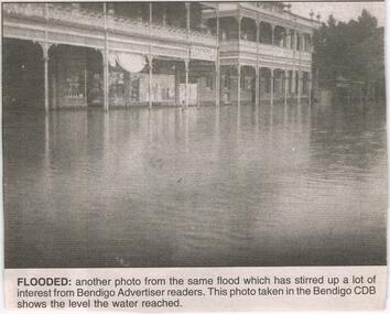
Newspaper - JENNY FOLEY COLLECTION: FLOODED
Bendigo Advertiser ''The way we were'' from 2003. Flooded: another photo from the same flood which has stirred up a lot of interest from Bendigo Advertiser readers. This photo was taken in the Bendigo CBD shows the level the water reached. The Way we were picture confusion: the way we were picture in the Bendigo Advertiser on February 5 is in fact not Bendigo at all. I believe the picture taken is of Rochester, Victoria. The two main buildings pictured are the Shamrock hotel and the Commercial hotel and next to that hidden behind the tree is the old Westpac building. T. Parsons, the name in the photo, used to be a clothing merchant in Rochester. Written by Brian Leahy, Rochester. The clip is in a folder.newspaper, bendigo advertiser, the way we were -
 Eltham District Historical Society Inc
Photograph - Digital Photograph, Alan King, Eltham Railway Trestle Bridge, 28 December 2007
Covered under National Trust of Australia (Victoria) State Significance and Heritage Overlay, Nillumbik Planning Scheme. Published: Nillumbik Now and Then / Marguerite Marshall 2008; photographs Alan King with Marguerite Marshall.; p103 The Eltham railway trestle bridge is the only one of its kind still regularly used in Melbourne’s metropolitan railway network. Opened in 1902, it is also one of Victoria’s very few timber rail bridges that still carries trains.1 The bridge is part of the railway line extension from Heidelberg - extended to Hurstbridge in 1912. This extension resulted in one of the greatest social changes experienced in Eltham Shire, as it considerably lessened its isolation attracting tourists, artists and suburban commuters particularly after World War Two.2 The bridge has been classified by the National Trust as historically, scientifically, aesthetically and socially significant at state level. But this has not always been recognised, and in 1977, locals fought to save it from destruction. The Victorian Railways proposed to replace the bridge with an earth embankment and large culverts to avoid maintenance problems and fire. This was rejected by the Eltham Council who protested that the bridge helped maintain the area’s rural character, historic link and beauty, as well as avoiding possible serious flooding on the flood plain if a culvert was blocked. The bridge stands as part of a National Trust classified landscape which includes the Alistair Knox Park, named after the local conservationist and architect who helped to make Eltham famous for its mud-brick houses. The landscape includes tall and spreading manna gums and candlebarks, and the historic Shillinglaw Cottage. Artist Walter Withers, one of the Heidelberg School of painters, painted the bridge early in the 20th century. The 38 span single-track railway bridge over creek and road has 34 timber-beam spans and four steel-joist spans, supported by four-pile timber piers and timber abutments. It has almost 200m of timber deck. All of the timbers have been replaced over the years, but the only change to the bridge’s character was the addition of pylons and wiring for electric trains in 1923. A petition for a railway to the shire was first made in 1883. A large deputation of local citizens to the Commissioner of Railways proposed a route passing through Alphington to midway between Greensborough and Eltham up the Diamond Creek valley towards Queenstown and Kinglake. As a result the Princes Bridge-Heidelberg Railway was opened in 1888. From 1888 locals demanded a railway extension. Kangaroo Ground farmers in particular, led by Shire Councillor and Member for Evelyn, Ewen Cameron, said it would assist local farmers and orchardists send their produce to the Melbourne market. In 1890, before the severe economic Depression, an extension of the line to Hurst’s Bridge (now Hurstbridge) was included in a new Railways Bill. The parliamentary delegations were regaled with a banquet at Hurst’s barn and entertained by the Diamond Creek Brass Band, but the extension was abandoned when the Depression struck in 1892-1893. The extension of the railway to Eltham, completed in 1902, was one of the few built in those hard times. That is why the Eltham timber-trestle railway bridge is a rare example of a broad-gauge rail bridge constructed between 1893 and 1910. At the opening, despite persistent drizzle, 300 children waving flags and banners were among the large crowd welcoming the first train, carrying official dignitaries, to Eltham. It had taken 24 years to bring the railway to Eltham. From then Eltham became a popular destination for outings. Mr Orford of Eltham recalled that after the railway came to Eltham ‘the craze for picnics on weekends and holidays began…. During the wattle season, wattle trains came to Eltham frequently. The visitors roamed the creek pulling great armfuls of wattle blossom to take back with them to Melbourne’.3 In 1926 the railway line was electrified as part of the metropolitan rail network. But the Victorian Railways decided not to complete the formerly planned Diamond Valley Railway to Queenstown (now St Andrews) and Kinglake.This collection of almost 130 photos about places and people within the Shire of Nillumbik, an urban and rural municipality in Melbourne's north, contributes to an understanding of the history of the Shire. Published in 2008 immediately prior to the Black Saturday bushfires of February 7, 2009, it documents sites that were impacted, and in some cases destroyed by the fires. It includes photographs taken especially for the publication, creating a unique time capsule representing the Shire in the early 21st century. It remains the most recent comprehenesive publication devoted to the Shire's history connecting local residents to the past. nillumbik now and then (marshall-king) collection, eltham railway trestle bridge, eltham trestle bridge -
 Charlton Golden Grains Museum Inc
Photograph, Charlton Tribune, B/W Photograph of 1973 Flooded Avoca River, February 1973
1973 Flooded Avoca River in Charlton Victoria at the Paterson Bridge. Water Level 25ft 1 1/2 inches - all local waterunframed 1973 Flooded Avoca River in Charlton Victoria at the Paterson Bridge. Water Level 25ft 1 1/2 inches - all local waterflood charlton victoria, james paterson bridge, local water -
 Bendigo Historical Society Inc.
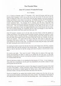
Document - HUSTLERS REEF MINE - JOHN M'CAVISTON'S WONDERFUL ESCAPE
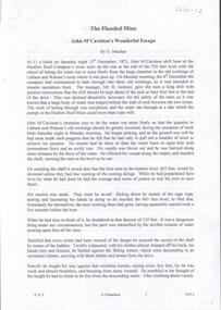
Ten page typed copy titled The Flooded Mine - John M'Caviston's Wonderful Escape by G. Mackay. The shift boss, John M'Caviston went to let water in the old workings of Latham and Watson's mine run more freely. He used the pick and removed a boulder. No sooner had he done this, the water burst in on him with a tremendous roar, blew his candle out and pushed him away. He escaped and warned the men as he ran. He then remembered four men at the bottom level and he went down to warn them. He descended the ladder and found them gone. He tried to get back up the ladder but could not. He went to a place where the floor had been built up. On the surface they thought he had been lost, but they started pumping and also baling. When the water level had dropped, men went down and on reaching the level one of them, Richard Williams, thought he heard a noise, and called out 'Jack'. They had found him alive.document, gold, hustlers reef mine, hustlers reef mine, john m'caviston's wonderful escape, the flooded mine, g mackay, hustlers reef company, latham & watson's mine, mr r jackson, hustlers reef mine, john m'caviston, j hooper, t o'connor, j derby, stanlake, cahill, richard williams, walter chapman -
 Bendigo Historical Society Inc.
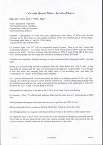
Document - DRAINAGE PROBLEMS - MINERS SENSATIONAL EXPERIENCE AT THE VICTORIA QUARTZ
Handwritten notes from a Bendigo Advertiser report, Thursday June 16th 1910. Management had for some time been apprehensive that the flooding in the deep mines to the south would affect them. Lansell's 180 took the precaution of baling. On the Tuesday night the men at the Victoria Quartz had a sensational experience. The storage dam at 3324 ft level receives the overflow from the flooded mines to the south. The level connects with the 3310 level at the Big 180. The water flows uninterrupted into thestorage dam which has a capacity of about 270 tanks. The dam had been emptied on Tuesday morning and work continued until 10 pm that night. The platman noticed that the water was coming down the shaft in a regular torrent. They didn't take much notice as they thought it was a leakinig outlet valve on the ascending tank. At 11 pm the releiving shift came down the shaft and said that the dam at 3,324 ft must be overflowing. The velocity of the water pouring down the shaft increased and the men made a hurried exit from the bottom of the shaft which is down 310 ft from the 4.254 ft plat (a total depth of 4,564 ft). An inspection of the dam at the 3324 ft level found it to be overflowing. By morning (Wednesday) the shaft had filled, and the water rose to 7 ft in the plat at 4254 feet. Mining inspector hgave orders that men were not to go below the 3324 ft level. Baling continued without cessation at the Big 180 all day and could not lower the water. Drilling machines etc and a powerful air winch at the 4254 ft plat are under water. An inspection made of the 3100 ft level at the 180 mine where the workings are connected with the New Chum & Victoria showed that water was running strongly from that mine proving that the inrush was due to flooded water from the southern deep mines to the south. Document from Albert Richardson Collection of mining history. Document from Albert Richardson Collection of mining history.document, gold, drainage problems, new chum drainage scheme, miners sensational experience at the victoria quartz, bendigo advertiser 16/6/1910 page7, lansell's 180, big 180, new chum & victoria -
 Bendigo Historical Society Inc.
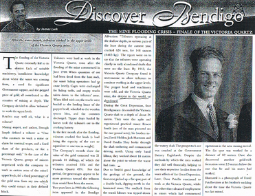
Document - LONG GULLY HISTORY GROUP COLLECTION: THE MINE FLOODING CRISIS - FINALE OF THE VICTORIA QUARTZ
BHS CollectionPhotocopy of a newspaper article titled Discover Bendigo by James Lerk titled The Mine Flooding Crisis - Finale of the Victoria Quartz. Soon after the flooding of the mine commenced in June 1910, tributers worked the upper levels. By 1913 the Company found it was uneconomic to allow tributers to continue working in the upper levels. Four Bendigo men, Ernest Smith, David Holden, Jack Harrison and David Patullo worked the mine during the Depression. They did well. A photo of David Patullo is in the article.bendigo, history, long gully history group, the long gully history group - the mine flooding crisis - finale of the victoria quartz, james lerk, victria quartz, brough smyth, bendigo advertiser 1912, great depression, ernest smith, david holden, jack harrison, david patullo, government battery eaglehawk -
 Wodonga & District Historical Society Inc
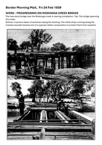
Photograph - Wodonga Creek Stock Bridge Collection
The Wodonga Creek Stock Bridge was constructed by the Country Roads Board in 1939. The date was recorded on a small plaque attached to one of the trestles. The bridge is an important reminder of one of the industries Wodonga was built on — cattle. It was constructed to develop a new stock route between Albury and Wodonga which would direct cattle away from the main bitumen roads and traffic bridges to the Wodonga Saleyards, where thousands of sheep and cattle were sold each month. It is a moderately tall timber trestle road bridge consisting of nine spans, with a deck length of 76 metres and deck width of 4.5 metres, and a maximum span length of 8.5 metres. The substantial timber deck featured decking laid horizontally and longitudinal running planks laid on top of it. The bridge also has timber side safety rails to discourage livestock from straying over the side. The bridge also became the centre of summer social activity for the young people of Wodonga as the area became a gazetted swimming area before the Wodonga Swimming Pool was constructed in 1959. In 1980 the Wodonga Saleyards were relocated to Bandiana to the east of the city. This meant that Wodonga Creek Stock Bridge was no longer needed for its original purpose. Although listed as a significant site by the Victorian Heritage and National Heritage Trust on 3/08/1998, the bridge fell into disrepair and also suffered damage from several floods. A suspension Bridge was constructed beside the Stock Route Bridge in 2013 and the old bridge was closed to traffic. Major damage caused by several floods, including a major flood in 2022 has resulted in the bridge being unsafe and its future is uncertain. The model of the Wodonga Creek Stock Bridge in our Collection made by Mr John Wild, depicts its current condition.The Wodonga Creek Stock Bridge is significant for technical, historic and social reasons and has been registered at the State Heritage level. It is of technical significance as a nine span bridge with tall timber trestles. Large bridges of this type are now very rare in Victoria. It is of historic significance as a surviving structurally authentic bridge designed specifically for livestock and drover use, on a historic stock route. The Stock Bridge is of social significance for its location at a popular riverside leisure spot since its construction in 1939.A collection of photographic images depicting the Wodonga Creek Stock Bridge. It contains both black and white and coloured images taken at different times in the Stock Bridge's history. A model of the Bridge made for Our Society is also included.wodonga creek stock bridge, wodonga heritage -
 Eltham District Historical Society Inc
Negative - Photograph, Harry Gilham, Grave of Richard George, Emily Ann (nee Davis) and Edith Jane Kaylock, Eltham Cemetery, Victoria, Sep 2009
In his early adult life, Richard Kaylock worked as a whaler (visiting California and New Zealand) and later as a drover on a large cattle station in New South Wales. In 1848 he came to Melbourne, working as a slaughterman, then settled in Eltham in 1854, his occupation thereafter being variously recorded as butcher or orchardist. He also had some experiences at Ballarat during the Eureka Rebellion. He died in 1910 at the age of 84. His obituary described him as a "striking personality" who was "brusque to a fault" and "strictly upright, expecting others to be the same". It seems from his will that he was illiterate. He is buried in Eltham Cemetery with his wife Emily. His property was in Wellington Street (now Brougham Street) and apparently extended across the Diamond Creek. The land on the western side of the creek was farmed, the house being on the eastern side. For many years the Brougham Street bridge was generally known as "Kaylock's Bridge". It formed part of the original coach road to Eltham and in 1922 was described as an "old rustic bridge". Its low level and insubstantial construction made it susceptible to flood damage, necessitating frequent closures until repairs could be carried out. The original bridge was demolished in 1923 and replaced by a "new up-to-date" one. When a lack of finances delayed repairs to the Bridge Street bridge in 1931, traffic had to detour via Brougham Street for some time. Local residents feared that the Bridge Street bridge might never reopen. In Loving Memory Of Our Dear Father & Mother R.G. and E.A. Kaylock Also E.J. Kaylock Died 21st Jan. 1927 The Eternal God Is My PledgeRoll of 35mm colour negative film, 6 stripsKodak GC 400-9eltham cemetery, gravestones, edith jane kaylock, emily ann kaylock (nee davis), richard george kaylock, brougham street bridge, kaylocks bridge -
 Bendigo Historical Society Inc.
Document - The Flooded Mine, John McCaviston's Escape, April, 2014
... hours in a level. Document The Flooded Mine, John McCaviston's ...Seven men were killed at the Great Extended Hustler's mine disaster on 2nd May 1914 by an explosion of dynamite occurring as the men were waiting at the plat to ascend the mine at the end of their shift. No blame was attached to anyone in the findings of the inquisition. It was unknown what caused the dynamite to explode. Three page typed document by Albert Richardson. Copy of handwritten document. 'The Flooded Mine, John McCaviston's Wonderful Escape' by G. Mackay (History of Bendigo). Article details the events that surrounded the flooding that occurred at the Hustlers Reef Company's mine on 13th December 1873. Water was being drained from the adjoining old workings of Latham and Watson, when the flow increased markedly, causing flooding. John McCaviston was the 'shift boss'., R. Jackson the Manager. McCaviston was saved after spending over 20 hours in a level.3527.2 on bottom of all pages. Duplicate copy. great extended hustlers, goldmining, accident, quartz, mining, flooding of mine, john mccaviston, mine rescue, r. jackson, latham and watson -
 Bendigo Historical Society Inc.
Photograph - AUSTIN COLLECTION: Ray Beer, Central Deborah Gold Mine
Ray Beer was an employee of the Central Deborah Gold Mine. February 15th 2009: Bendigo Advertiser: 'MINING stalwart Raymond Beer has died at the age of 74 after a battle with cancer. He leaves behind an extended family and a legacy in Bendigo’s mining history. Ray was mine manager at the Central Deborah Gold Mine - appointed in 1978 - and led the team that made possible the underground project at the second level. He had a vision to allow visitors to go underground and experience Bendigo’s mining heritage first hand. Ray was responsible for developing the new battery, shaft and poppet head to make this a reality. It took persistence and lots of hard work. Friend and work colleague Bill McNamara said Ray was as good as 10 men. His enthusiasm and work ethic were unprecedented. Ray will be sadly missed by his wife, Thelma, six children, 15 grandchildren, seven brothers, three sisters, his extended family, and friends. He will be remembered for his kindness, tenacity and strength of character. In recognition of his contribution to Bendigo’s mining history, after more than 20 years of service at his retirement, a bronze life-sized statue was unveiled in his honour'. Central Deborah Gold Mine history: At its peak, Central Deborah Gold Mine reached a depth of 412 metres. It has 17 separate levels and 15 kilometres of drives and cross cuts (tunnels). The Central Deborah was very much a hands-on mine and the conditions that the miners worked in would be considered shocking by today's standards – being lowered underground in a cage with only two sides, often working ankle to knee deep in water, filling up to 32 ore trucks a shift by hand which were then pushed a mile or more along rails in the drives, working by carbide lamp, breathing in the fumes and rock dust and communication by bells. Geez, they were ironmen. However, at the time working conditions were considered to be among the best on the goldfields at Central Deborah, after all it was one of the only mines that had hot showers. Following Central Deborah Gold Mine's closure, the Bendigo skyline began to noticeably change. Obvious remnants of mining such as poppet heads, engine rooms, service quarters, battery houses and chimneys were steadily disappearing. After intense lobbying by the local community, the Bendigo City Council purchased the still very much intact Central Deborah Gold Mine in 1970 for a mere $6,000 to ensure that a vital link to Bendigo's historic golden past was maintained. The Bendigo Trust was then formed to oversee the operations of the Central Deborah Gold Mine, which led to the surface of the mine being opened to the public in 1971. Initially the surface was open for just 12 hours a week and as the demand for viewing a part of Bendigo's history increased, so did the opening hours. In 1974 the mine was gazetted as a Public Historical Purposes Reserve and attracted such visitors as H.R.H Prince Charles. By far the greatest shortcoming at this stage was that no one could view the underground workings, as these had become flooded. After what could only be described as a monumental effort by everyone involved, Level 2 of the mine was officially opened to the public by the Premier of Victoria, the Honourable John Cain, on 20 June 1986, which brought to fruition a long standing dream.Black and white photograph. Ray Beer, underground at Central Deborah Gold Mine, standing alongside wooden sign 'Murrell's Corner'. Sign is placed horizontally on timber supports; side of drive visible in background. Ray is wearing bib and brace overalls and hard hat with a belt around his waist. He is giving a 'thumbs up' sign. gold mining, central deborah gold mine, ray beer, mine manager -
Bendigo Historical Society Inc.
Photograph - AUSTIN COLLECTION: Central Deborah Gold Mine Lift Shaft
Central Deborah Gold Mine history: At its peak, Central Deborah Gold Mine reached a depth of 412 metres. It has 17 separate levels and 15 kilometres of drives and cross cuts (tunnels). The Central Deborah was very much a hands-on mine and the conditions that the miners worked in would be considered shocking by today's standards – being lowered underground in a cage with only two sides, often working ankle to knee deep in water, filling up to 32 ore trucks a shift by hand which were then pushed a mile or more along rails in the drives, working by carbide lamp, breathing in the fumes and rock dust and communication by bells. Geez, they were ironmen. However, at the time working conditions were considered to be among the best on the goldfields at Central Deborah, after all it was one of the only mines that had hot showers. Following Central Deborah Gold Mine's closure, the Bendigo skyline began to noticeably change. Obvious remnants of mining such as poppet heads, engine rooms, service quarters, battery houses and chimneys were steadily disappearing. After intense lobbying by the local community, the Bendigo City Council purchased the still very much intact Central Deborah Gold Mine in 1970 for a mere $6,000 to ensure that a vital link to Bendigo's historic golden past was maintained. The Bendigo Trust was then formed to oversee the operations of the Central Deborah Gold Mine, which led to the surface of the mine being opened to the public in 1971. Initially the surface was open for just 12 hours a week and as the demand for viewing a part of Bendigo's history increased, so did the opening hours. In 1974 the mine was gazetted as a Public Historical Purposes Reserve and attracted such visitors as H.R.H Prince Charles. By far the greatest shortcoming at this stage was that no one could view the underground workings, as these had become flooded. After what could only be described as a monumental effort by everyone involved, Level 2 of the mine was officially opened to the public by the Premier of Victoria, the Honourable John Cain, on 20 June 1986, which brought to fruition a long standing dream.Black and white photograph, looking from bottom of lift shaft towards the surface; light visible at top of shaft. Lift cables and safety mesh on sides of shaft. gold mining, central deborah gold mine, ray beer, mine manager -
Bendigo Historical Society Inc.
Photograph - AUSTIN COLLECTION: Central Deborah Gold Mine, Possibly 1990's
Central Deborah Gold Mine history: At its peak, Central Deborah Gold Mine reached a depth of 412 metres. It has 17 separate levels and 15 kilometres of drives and cross cuts (tunnels). The Central Deborah was very much a hands-on mine and the conditions that the miners worked in would be considered shocking by today's standards – being lowered underground in a cage with only two sides, often working ankle to knee deep in water, filling up to 32 ore trucks a shift by hand which were then pushed a mile or more along rails in the drives, working by carbide lamp, breathing in the fumes and rock dust and communication by bells. Geez, they were ironmen. However, at the time working conditions were considered to be among the best on the goldfields at Central Deborah, after all it was one of the only mines that had hot showers. Following Central Deborah Gold Mine's closure, the Bendigo skyline began to noticeably change. Obvious remnants of mining such as poppet heads, engine rooms, service quarters, battery houses and chimneys were steadily disappearing. After intense lobbying by the local community, the Bendigo City Council purchased the still very much intact Central Deborah Gold Mine in 1970 for a mere $6,000 to ensure that a vital link to Bendigo's historic golden past was maintained. The Bendigo Trust was then formed to oversee the operations of the Central Deborah Gold Mine, which led to the surface of the mine being opened to the public in 1971. Initially the surface was open for just 12 hours a week and as the demand for viewing a part of Bendigo's history increased, so did the opening hours. In 1974 the mine was gazetted as a Public Historical Purposes Reserve and attracted such visitors as H.R.H Prince Charles. By far the greatest shortcoming at this stage was that no one could view the underground workings, as these had become flooded. After what could only be described as a monumental effort by everyone involved, Level 2 of the mine was officially opened to the public by the Premier of Victoria, the Honourable John Cain, on 20 June 1986, which brought to fruition a long standing dream.Black and white photograph. Two men with hard hats and lights, inspecting quartz outcrop on wall of drive at Central Deborah Gold Mine.gold mining, central deborah gold mine, ray beer, mine manager -
Bendigo Historical Society Inc.
Photograph - AUSTIN COLLECTION: Operating rock drill, Central Deborah Gold Mine, Possibly 1990's
Central Deborah Gold Mine history: At its peak, Central Deborah Gold Mine reached a depth of 412 metres. It has 17 separate levels and 15 kilometres of drives and cross cuts (tunnels). The Central Deborah was very much a hands-on mine and the conditions that the miners worked in would be considered shocking by today's standards – being lowered underground in a cage with only two sides, often working ankle to knee deep in water, filling up to 32 ore trucks a shift by hand which were then pushed a mile or more along rails in the drives, working by carbide lamp, breathing in the fumes and rock dust and communication by bells. Geez, they were ironmen. However, at the time working conditions were considered to be among the best on the goldfields at Central Deborah, after all it was one of the only mines that had hot showers. Following Central Deborah Gold Mine's closure, the Bendigo skyline began to noticeably change. Obvious remnants of mining such as poppet heads, engine rooms, service quarters, battery houses and chimneys were steadily disappearing. After intense lobbying by the local community, the Bendigo City Council purchased the still very much intact Central Deborah Gold Mine in 1970 for a mere $6,000 to ensure that a vital link to Bendigo's historic golden past was maintained. The Bendigo Trust was then formed to oversee the operations of the Central Deborah Gold Mine, which led to the surface of the mine being opened to the public in 1971. Initially the surface was open for just 12 hours a week and as the demand for viewing a part of Bendigo's history increased, so did the opening hours. In 1974 the mine was gazetted as a Public Historical Purposes Reserve and attracted such visitors as H.R.H Prince Charles. By far the greatest shortcoming at this stage was that no one could view the underground workings, as these had become flooded. After what could only be described as a monumental effort by everyone involved, Level 2 of the mine was officially opened to the public by the Premier of Victoria, the Honourable John Cain, on 20 June 1986, which brought to fruition a long standing dream.Black and white photograph. Two men with hard hats and lights standing in front of underground rock surface at Central Deborah Gold Mine. Man on left hand side of image is operating a small rock drill. Man on right hand side is observing the procedure. gold mining, central deborah gold mine, rock drill, underground