Showing 946 items
matching ownership
-
 Melbourne Tram Museum
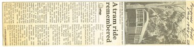
Newspaper, Burwood Press, "A tram ride remembered", 3/08/1998 12:00:00 AM
Newspaper clipping - from the Progress Press, 3/8/1998 titled "A tram ride remembered", recalling the history of Wattle Park tram trips by Gwen McWilliam in the papers heritage section and the history of the ownership of the land the tram line. Includes a reference to the 1928 derailment of a tram at the railway gates. Includes a photo of a tram at the park.On the top edge in ink "Progress Press 3 Aug 1998 p 28"trams, tramways, wattle park, derailments, history -
 Melbourne Tram Museum
Document - Photocopy, "A History of Commonwealth Engineering 1977 - 1985", 2019
Photocopy of pages 210 to 221 of "A History of Commonwealth Engineering 1977 - 1985" which looks at the history of the "Z4 concept, the Lonie Report, Low Floor tram proposals, senior staff at Dandenong, ownership changes, A class, Prototype Articulated trams (B class), in service modifications, the failed Knorr Brake Franchise and ANI takeover.trams, tramways, comeng, commonwealth engineering, a class, b class, new trams, articulated trams, lonie report -
 Linton Mechanics Institute and Free Library Collection
Book, Attenborough, G. M, Lady of Daylight : a portrait in blue and gold, 1930
320 p.fictionfiction -
 Federation University Historical Collection
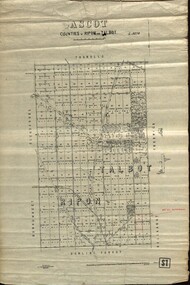
Plan - map, Ascot: Counties of Ripon and Talbot, 18/12/1920
Cadastral map showing parish boundaries and land ownership. "L5270"Maps parishes located in Ascot area. Photo-Lithographed at the Dept. of Lands and Survey.Highlighted parish labelled, Mrs E.C.Sutherland.parish, map, ascot, counties, e. c. sutherland, a. cameron, sweeney, w. j. clarke, mount hollowback, tourello, burrumbeet, glendaruel, dowling forest, a. j. mullett, w. j. butson, 1920, william coghill, chatham, chatham family collection, mrs e.c.sutherland. -
 Bendigo Historical Society Inc.
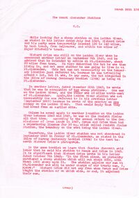
Document - ''THE MOUNT ALEXANDER STATIONS'': SHORT ARTICLE, 24/03/1969
''The Mount Alexander Stations'' - short article of few pages dated March 24th 1969 . Detailed discussion of early ownership of pastoral licences in the area. Author (presumably - as underneath title) is H.C. Reference to Richard Grice; Powlett Plains; Heape; Charles Sherratt; Fenton; Gibson; Mt. Alexander Station; Mt. Alexander North ; William Barkerbendigo, land sales, pastoral licences, mount alexandra station, richard grice, powlett plains. lodden river. -
 Bendigo Historical Society Inc.
Document - RESEARCH PAPERS: EPSOM HJ JONES SHAMROCK HOTEL
A 14 page document detailing the history of William Davys Jone's family and businesses history regarding his ownership of multiple butchers and the Epsom Shamrock Hotel which was on the corner in front of 27 Howard St and was demolished in 1930, the land is now occupied by many large businesses like Woolworths and Aldi and is now being developed into many storefronts. -
 Bendigo Historical Society Inc.
Document - IAN DYETT COLLECTION: Deed of Gift Dated 12.7. 2011
IAN DYETT COLLECTION: Deed of Gift Dated 12.7. 2011 between John Damian Sampson and Ian Maxwell Dyett to provide Provenance Ownership Rights to the various artifacts of Sir Gilbert Joseph Cullen Dyett,KCMC. Black print and signatures on blue A4 paper. One signature in blue ink dated 2/4/2025 knighthood, gilbert dyett, george the fifth -
 Greensborough Historical Society
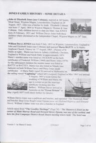
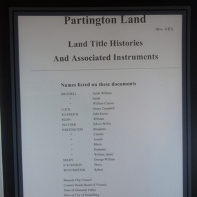
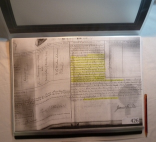
Folder of Documents, Partington land: Land Title Histories and Associated Instruments, 1826o
Land title documents trace the ownership of land owned by the Partington family of Greensborough.The Partington family are Greensborough pioneers and have lived in the area since the 1840s.Folder of copies of land title documents. 36 pages. partington, plenty river, banyule city council, shire of heidelberg, shire of diamond valley -
 Greensborough Historical Society
Map, Victoria. Department of Crown Lands and Survey, Keelbundoora; Counties of Bourke and Evelyn, 1950c
Map of the Victorian counties of Bourke and Evelyn showing parish boundaries and land ownership.Show the original landholders for this area.Map on light brown parchment, covered in plastic."L.5305" and "3462" -
 Melbourne Tram Museum
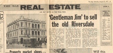
Newspaper, The Age, " 'Gentleman Jim' to sell the old Riversdale", 27/08/1977 12:00:00 AM
Newspaper clipping from The Age, Saturday 27-8-1977, Real Estate section, titled " 'Gentleman Jim' to sell the old Riversdale" about the sale of Riversdale Hotel at the corner of Auburn Road and Riversdale hotel. Article includes a photograph of the Hawthorn horse tram in front of the hotel and the ownership history of the hotel - been owned by the same family since 1934.trams, tramways, auburn rd, riversdale rd, hotels, horse trams -
 The Beechworth Burke Museum Research Collection
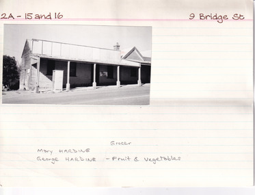
Card (Series) - Index Card, George Tibbits, 9 Bridge Street, Beechworth, 1976
George Tibbits, University of Melbourne. Faculty of Architecture, Building and Town & Regional PlanningIndex system that support the research for Beechworth : historical reconstruction / [by] George Tibbits ... [et al]Arranged by street names of BeechworthEach index card includes: street name and number of property, image of property, allotment and section number, property owners and dates of ownership, description of the property according to rate records, property floor plan with dimensions.beechworth, george tibbitsbeechworth, george tibbits -
 Linton Mechanics Institute and Free Library Collection
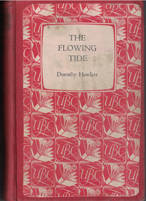
Book - Novel, Hewlett, Dorothy, The Flowing Tide by Dorothy Hewlett, 1956
Heroine Elinor Munro survives a shipwreck and is given a chance to make good.Hardcover book with a red fabric cover. 320 pages.fictionHeroine Elinor Munro survives a shipwreck and is given a chance to make good.dorothy hewlett, shipwrecks, fiction -
 The Beechworth Burke Museum Research Collection
Card (Series) - Index Card, George Tibbits, Street number and name plus Beechworth, 1976
George Tibbits, University of Melbourne. Faculty of Architecture, Building and Town & Regional PlanningIndex system that support the research for Beechworth : historical reconstruction / [by] George Tibbits ... [et al]Arranged by street names of BeechworthEach index card includes: street name and number of property, image of property, allotment and section number, property owners and dates of ownership, description of the property according to rate records, property floor plan with dimensions.beechworth, george tibbitsbeechworth, george tibbits -
Glen Eira Historical Society
Document - Lirrewa
Three documents about the history of this property. Handwritten notes on the history of Lirrewa’s ownership by Iren V Anderson including transcription of a letter and newspaper extracts relating to some of the families associated with the property c 1982 Summary of handwritten notes on the history of Lirrewa’s ownership by Irene V Anderson 1982 Handwritten timeline and family tree undated and unsignedlangdon montague william, langdon henry joseph, langdon charles, riddoch elizabeth helen, riddoch john, langdon leslie john, langdon mary elizabeth, langdon dorothy, campbell james, franklin charles reed, langdon john riddoch, gillespie mary helen, langdon john james, langdon judith reed, tarqua, caulfield town hall, glen eira road, hawthorn road, langdon margery, rosecraddock, hengar, lincluden, foster elizabeth, renwick samuel, campbell ewan, franklin mary, sinclair aj, bellatti jean, the garrell, caulfield, elsternwick, st marys anglican church, langdon madge, campbell violet, campbell bert, campbell charlie, langdon cp, langdon blanche, langdon cp mrs, parsons mrs, parson miss, glen rosa, campbell jc, pinder mrs, eames mrs, stewart mr, stewart mrs, landgon willie, langdon frank, farrar miss, langdon mw mrs, brooks walter, brooks gladys, langdon mw, tennant dr, cox james dr, grant rs, black rs, anderson p, russell edwin r, bryce percy h, renwick jane, world war 1914-1918, weddings, horses, cumloden school, fairelight school, anderson irene v -
Kew Historical Society Inc
Archive (series) - Subject File, Kew Historical Society et al, 'Iveagh', Studley Park Road, 1993
Various partiesReference, Research, InformationSecondary Values (KHS Imposed Order)Subject file containing a 16-page manuscript recording the history of Iveagh in Studley Park Road, Kew from the earliest land sales to the ownership of the house by the Pallottine Fathers. Jean-Marie Labdanum and Dorothy Lyons created the manuscript in 1993 as part of a school research project. [There is also an article in KHS Newsletter 107, June 2014 by Kerry Fairbank on the history of the building].kew historical society - archives, kew - history, pallotine fathers, iveagh - 169 studley park road - kew (vic), john bakewell, richard goldsborough, william de graves, john mckenzie, john miller, thomas greenwood, thomas nankivell, george ramsden, patrick mcginnis, studley heights estatekew historical society - archives, kew - history, pallotine fathers, iveagh - 169 studley park road - kew (vic), john bakewell, richard goldsborough, william de graves, john mckenzie, john miller, thomas greenwood, thomas nankivell, george ramsden, patrick mcginnis, studley heights estate -
 Bacchus Marsh & District Historical Society
Map, Coimadai Parish Map, County of Bourke. Circa 1890s-1900s
The cadastral Parish of Coimadai, a subdivision of the County of Bourke, lies directly north of the township of Bacchus Marsh. The date of this map is uncertain. T.F. McGauran the person who made a photo-lithographic copy of the map was in charge of photo-lithography at the Victorian Department of Lands and Survey in the late 19th century until about 1910.A single page paper map showing the map for the Parish of Coimadai in the County of Bourke. A cadastral map showing parish boundaries and land ownership. A rectangle shaped area is missing from the centre of the map due to a tear or deliberate excision. The map is pasted into a bound volume containing 76 maps or plans in total. High resolution digital image stored on BMDHS computer network. Photo-lithographed at the Department of Lands and Survey, Melbourne by T.F. McGauran 26.8.[??] NOTE. Photo litho from L.P showing temporary surveys and occupation of land prepared for departmental use onlybacchus marsh region parish plans, coimadai parish maps, coimadai parish plan -
 Greensborough Historical Society
Document collection, Copies of Poulter family documents, 1880o
Records some land ownership, birth, deaths and marriages of the Poulter family of Greensborough. Dates from 1880s.Copies of documents, land titles and birth, death and marriage certificates.Mainly handwritten records.poulter family, land titles, greensborough -
 Greensborough Historical Society
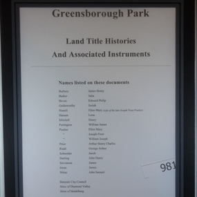
Folder of Documents, Greensborough Park: Land Title Histories and Associated Instruments, 1872-1976
Land title documents trace the ownership of what is now known as Greensborough Park from 1872 to 1976.This property was owned at various times by well known Greensborough identities. The documents show the change from private ownership to public ownership of the site.Folder of copies of land title documents. 20 pages. Includes CD of electronic copies.greensborough park, banyule city council, shire of heidelberg, shire of diamond valley -
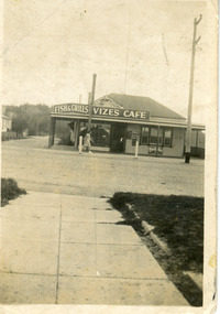 Lakes Entrance Historical Society
Photograph - Vizes Cafe, 1939c
Name changes with change of ownership, finally Bamboo Cafe, rebuilt as Bamboo Motel 1960c by Con Coucoulos.Black and white snapshot of Vize's Cafe, showing sign for Fish Grills, over veranda, large Bushell's Tea sign on wall. Building appears to be remodelled weatherboard residence, set on a corner block, facing Esplanade. A billiard room was situated behind the cafe. Lakes Entrance Victoriarestaurant, room display -
 Greensborough Historical Society
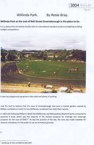
Article, Rosie Bray, Willinda Park, by Rosie Bray, 1963_
Willinda Park is at the end of Nell Street Greensborough. This article, written in 2017, is a description and history of ownership of the athletics park.Two page typescript, colour photographs.athletics, willinda park, william holmes, beatrice linda holmes, nell street greensborough -
 Kilmore Historical Society
Gentleman's Magazine, Gentleman's Magazine, Vol. 2, 1869, 1869
Quarterly British Magazine for Gentlemen. "Entirely new series". December - May 1869. Hardcover book with marbelled cover, leather corners and spine. Cover worn with loss of colour. Leather corners worn, leather spine torn. Green ownership label on front cover. Front cover partially detached from body. Binding loose. Evidence of previous insect damage to front flyleaf & inside back cover (non-active).Foxing throughout. 748 pp. Fair condition.Flyleaf, '050/R69'/'159' handwritten & underlined/Kilmore Mechanics Institute stamp.british gentleman's magazine, kilmore mechanics institute library. -
 Greensborough Historical Society
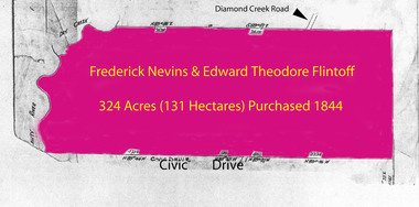
Folder of documents, Flintoff - various documents, 1844_
Records the Flintoff family's ownership of parcels of land in the Greensborough area. Includes a survey plan for acquisition of land for the aqueduct 1897.Various photocopies of title documents relating to land owned by the Flintoff family in Greensborough.Mainly handwritten documents dating from early 20th century.flintoff family, land titles, greensborough, aqueduct -
 Kew Historical Society Inc
Plan, Melbourne & Metropolitan Board of Works : Borough of Kew : Detail Plan No.1581, 1904
The Melbourne and Metropolitan Board of Works (MMBW) plans were produced from the 1890s to the 1950s. They were crucial to the design and development of Melbourne's sewerage and drainage system. The plans, at a scale of 40 feet to 1 inch (1:480), provide a detailed historical record of Melbourne streetscapes and environmental features. Each plan covers one or two street blocks (roughly six streets), showing details of buildings, including garden layouts and ownership boundaries, and features such as laneways, drains, bridges, parks, municipal boundaries and other prominent landmarks as they existed at the time each plan was produced. (Source: State Library of Victoria)This plan forms part of a large group of MMBW plans and maps that was donated to the Society by the Mr Poulter, City Engineer of the City of Kew in 1989. Within this collection, thirty-five hand-coloured plans, backed with linen, are of statewide significance as they include annotations that provide details of construction materials used in buildings in the first decade of the 20th century as well as additional information about land ownership and usage. The copies in the Public Record Office Victoria and the State Library of Victoria are monochrome versions which do not denote building materials so that the maps in this collection are invaluable and unique tools for researchers and heritage consultants. A number of the plans are not held in the collection of the State Library of Victoria so they have the additional attribute of rarity.Original survey plan, issued by the MMBW to a contractor with responsibility for constructing sewers in the area identified on the plan within the Borough of Kew. The plan was at some stage hand-coloured, possibly by the contractor, but more likely by officers working in the Engineering Department of the Borough and later Town, then City of Kew. The hand-coloured sections of buildings on the plan were used to denote masonry or brick constructions (pink), weatherboard constructions (yellow), and public buildings (grey). The streets and built structures in this plan were surveyed in 1903 and released to contractors in 1904. In addition to the designation of building types by colour, the plan includes detailed descriptions of land use and ownership. While many buildings remain from this period, a number of the buildings represented have been demolished including the original Kew Town Hall, and the Congregational and Roman Catholic churches in Walpole Street. While the mansion ‘Illapa’ in Princess Street is still extant – now part of ‘Rylands’ – the neighbouring mansion ‘Elsmere’ was demolished some decades ago. Rivalling Illapa and Elsmere in size were two mansions in Walpole Street, one named on the plan as ‘Gnarlbine’. Over time, Kew Junction and the south side of High Street have been reconfigured and widened, so that the commercial buildings on the corner of Princess and High Street no longer exist. A surprising feature of this part of central Kew to the northwest of Kew Junction is the amount of vacant land. In a number of cases, this land is noted by the contractor as used for vegetable gardens.melbourne and metropolitan board of works, detail plans, maps - borough of kew, mmbw 1581, cartography -
 The Beechworth Burke Museum Research Collection
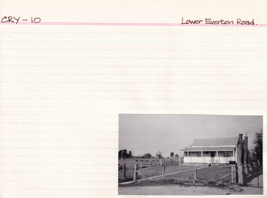
Card (Series) - Index Card, George Tibbits, Lower Everton Road, Beechworth, 1976
George Tibbits, University of Melbourne. Faculty of Architecture, Building and Town & Regional PlanningIndex system that support the research for Beechworth : historical reconstruction / [by] George Tibbits ... [et al]Arranged by street names of BeechworthEach index card includes: street name and number of property, image of property, allotment and section number, property owners and dates of ownership, description of the property according to rate records, property floor plan with dimensions.beechworth, george tibbitsbeechworth, george tibbits -
 Melbourne Tram Museum
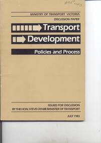
Document - Report, Minister of Transport, "Discussion Paper - Transport Development Policies and Process", Jul. 1983
Report - 80 pages - perfect bound with brown covers, titled ""Discussion Paper - Transport Development Policies and Process", issues by Minister for Transport, Hon. Steve Crabb, July 1983. Looks at state transport, public transport, new transport authorities, administration. Has index and many charts, revenues, expenses, funding, road fatality statistics, road safety, population growth, travel rates and car ownership.Has on inside front cover, pencil notes regarding specific points in the study. On front cover in ink "?? copy"trams, tramways, discussion paper, transport, mmtb, tramways, railways, road transport, minister for transport -
 Bayside Gallery - Bayside City Council Art & Heritage Collection
Map, Department of Crown Lands and Survey, Moorabbin, County of Bourke, c. 1918
The cadastral map of the Parish of Moorabbin in Victoria (L.6104) shows parish boundaries and land ownership c. 1918 when Sandringham was a Borough.moorabbin, county of bourke, map, plan, land subdivision, land titles, foreshores, sndringham, hampton, beaumaris, highett, cheltenham, department of lands and survey, land owners, cartographic material, borough of sandringham, brighton -
 Kew Historical Society Inc
Plan, Melbourne and Metropolitan Board of Works, Borough of Kew : Detail Plan No.1580, 1904
The Melbourne and Metropolitan Board of Works (MMBW) plans were produced from the 1890s to the 1950s. They were crucial to the design and development of Melbourne's sewerage and drainage system. The plans, at a scale of 40 feet to 1 inch (1:480), provide a detailed historical record of Melbourne streetscapes and environmental features. Each plan covers one or two street blocks (roughly six streets), showing details of buildings, including garden layouts and ownership boundaries, and features such as laneways, drains, bridges, parks, municipal boundaries and other prominent landmarks as they existed at the time each plan was produced. (Source: State Library of Victoria)This plan forms part of a large group of MMBW plans and maps that was donated to the Society by the Mr Poulter, City Engineer of the City of Kew in 1989. Within this collection, thirty-five hand-coloured plans, backed with linen, are of statewide significance as they include annotations that provide details of construction materials used in buildings in the first decade of the 20th century as well as additional information about land ownership and usage. The copies in the Public Record Office Victoria and the State Library of Victoria are monochrome versions which do not denote building materials so that the maps in this collection are invaluable and unique tools for researchers and heritage consultants. A number of the plans are not held in the collection of the State Library of Victoria so they have the additional attribute of rarity.Original survey plan, issued by the MMBW to a contractor with responsibility for constructing sewers in the area identified on the plan within the Borough of Kew. The plan was at some stage hand-coloured, possibly by the contractor, but more likely by officers working in the Engineering Department of the Borough and later Town, then City of Kew. The hand-coloured sections of buildings on the plan were used to denote masonry or brick constructions (pink), weatherboard constructions (yellow), and public buildings (grey). The area represented in this detail plan has undergone significant change during the 20th century. The widening of High Street in the 1930s and 1950s involved the shops on the south side of High Street being demolished and later rebuilt to fit the widened street. Another significant loss was the mansion ‘Drayton’ fronting Wellington Street, owned at this stage by Susannah Fenton. Her family name would later to be given to Fenton Way, which was to be built over the grounds of the house following its demolition. The plan of the garden is particularly interesting, containing a batten dome fronting Wellington Street, an ornamental pond, a fountain and a brick and glass conservatory. The notes by the plumbing contractor on this plan are particularly detailed. Pink borders delineate the ownership of the varying parcels of land. Some of the better known owners listed include the real estate agent Cr. Henry de Castres Kellett (bt) and John Padbury, the funeral director. This particular plan provides a clear view of the configuration of the Kew Junction in 1903 and the commercial buildings that surrounded it.melbourne and metropolitan board of works, detail plans, maps - borough of kew, mmbw 1580, cartography -
 Federation University Historical Collection
Document, Ballarat School of Mines and Ballarat Historical Park Association, 15/07/1982
A agreement relating to the loan and ongoing custodianbship of three items from the Ballarat School of Mines Museum. The Model Dray, Model Phoenix Locomotive, Model Battery and Model HV McKay Smithy are to remain in the custody of Sovereign Hill, plaques to be placed in each model to display Ballarat School of Mines involvement in their creation, and if Sovereign Hill no longer requires the models ownership to be returned to the Ballarat School of Mines (nor Federation University Australia)model, agreement, museum, model dray, model phoenix locomotive, model battery, model hv mckay smtihy -
 Orbost & District Historical Society
register, Register of Residence Areas, 10.2.1897 - 4.9.1934
This book is a register of land holders with miners' rights. The correspondence is associated with applications for miners' rights on privately owned land and business sites. They include application fotrms and objections to registrations. The areas referred to are Combienbar, Goongerah, Club Terrace, Wombat Creek and Dundong. One of the privileges under the Mines Act, conferred by the holding of a miner's right until 1935 was that of residence on up to one acre on a gold-fields area. Those occupying a residence area were "deemed in law to be possessed ... of such ... parcels ... and the property therein".This is a useful research tool.A large, heavy book with a grey cloth cover and red spine. The end papers are marbled. The inside pages are ruled in grey with red ruled columns. Entries are hand-written. There are copies of correspondence inside. Details given are the registration number and date, the name of the person, the number of the miner's right and its date, a description of the allotment and any remarks or references to other volumes. Any changes of ownership are shown. The book is mostly unused.register-mining miners-rights -
Glen Eira Historical Society
Document - Orrong Road, 56, Elsternwick
Caulfield Conservation Study on 56 Orrong Road, Elsternwick dated October 1994 and produced by Andrew Ward. Includes a brief architectural description and history of ownership.caulfield conservation study, federation style, architectural styles, architectural features, rowan andrew, elsternwick, orrong road, land subdivision, gardenvale estate, paterson john, paterson catherine, paterson amy, mclaughlin albert, ward andrew, gables, verandahs, tiles, land values