Showing 200 items
matching quartz hill
-
 Bendigo Historical Society Inc.
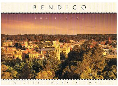
Book - BENDIGO - THE REGION TO LIVE, WORK & INVEST
Pale yellow 12 page book titled 'Bendigo the Region to Live Work & Invest'. On the front cover is a scenic view of Bendigo and on the back cover a picture of some quartz and gold nuggets on a green background. Sections in the book are: Live Work & Invest, Lifestyle, Access, Community, Infrastructure, Labour Force, Business, Opportunity, Successes and Information. Each page has a colour picture, they are:- Hargreaves Mall, Eaglehawk Golf Course, Map of Victoria, La Trobe University, Big Hill, Regional Office Department of Planning & Development, Sandhurst Farms, Construction Activity, Products of the Region, Dr. Ian Macbean, Mr Evan Jones and the Capital Theatre with information on each.book, bendigo, bendigo, bendigo - the region to live, work & invest, bendigo regional development board, dr ian macbean, mr evan jones, kate mildren, richard gibbs, express printers, hargreaves mall, eaglehawk golf course, map of victoria, la trobe university, big hill, regional office department of planning & development, sandhurst farms, construction activity, products of the region, capital theatre -
 Bendigo Historical Society Inc.
Document - LONG GULLY HISTORY GROUP COLLECTION: TALES OF VICTORIA HILL
Two printed pages titled Tales of Victoria Hill. Mentioned is the gold yield on the New Chum Line of Reef, early gold discovery, Christopher Ballerstedt and his son Theodore, Theodore building Fortuna as well as a crusher or battery in its grounds. He believed he had exhausted the riches from his claims and sold the claim on the hill to George Lansell, deepest gold mine, interconnecting to neighbouring mines to obtain the required up and down drafts for ventilation, rising of the water levels resulting the closure of the Victorian Quartz Mine when a rope broke and the equipment that is still there. An accompanying photo of the Victoria Quartz Mine shows the buildings, chimney and poppet legs and a man standing in front of a building. There is also an accompanying floppy disc.bendigo, history, long gully history group, the long gully history group - tales of victoria hill, j n macarthy, christopher ballerstedt, theodore ballerstedt, fortuna, george lansell, lansell's 180, victoria quartz co, victorian consols, bendigo's deepest known gold bearing reef -
 Bendigo Historical Society Inc.
Document - LONG GULLY HISTORY GROUP COLLECTION: GUIDE TO SOME FAMOUS MINES
Three pages titled Guide to Some Famous Mines. Compiled by A Richardson. Each mine is listed as on the reef it is situated on. Reefs are The New Chum Line of Reef and the Garden Gully Line of Reefs, and the Devonshire Group. Mentioned is the mine's location, depth of shaft, poppet legs, machinery, location of engine house, gold yield, dividends and owners of mine. The mines are: The New Chum Line of Reef. The New Chum Railway, Kochs Pioneer, Windmill Hill, Confidence Extended, Johnson's No 1, Johnson's No2, Johnson's No 3, North Johnson's, Princess Dagmar, Golden Age, Johnson's Reef Extended, Golden Pyke, Constellation, Great Northern, Virginia, Specimen Hill United, New Argus, Clarence United, North Argus, South New Moon, New Chum Hill, The New Chum and Victoria, Catherine Reef United. Garden Gully Line of Reefs. The Great Southern, Ulster United, Londonderry, South Garden, The Sea Amalgamated, Garden Gully United, Victory and Pandora, Unity Mine, Carlisle United, Cornish United, Eureka Extended, South Belle Vue United, Shenandoah, Shamrock, New Chum Consolidated, New Chum United, Lansell's 222, Rae's Open Cut, Great Central Victoria, Victoria Consols, The Ironbark, Hercules and Energetic, Pearl, The Devonshire Group. North of Staley,The Duke of Edinburgh, New St Mungo, Duchess Tribute, South Devonshire, Duchess of Edinburgh, Princess Alexandra, West United Devonshire, Hopewell, Phoenix. Yhe Mungo Mines. Unicorn, South St Mungo, Lady Barkly, The St Mungo, Sadowa, Eastwood. Snobs Hill Group. The Ellenborough, The Belmont and Saxby, York and Durham, The Acadia, William's United, The Victoria Hill - Ironbark, The North Old Chum, Lansell's Big 180, Ballerstadt's Open-Cut and The Victoria Quartz.bendigo, history, long gully history group, the long gully history group - guide to some famous mines, a richardson, the new chum railway, kochs pioneer, windmill hill, confidence extended, johnson's no 1, johnson's no2, johnson's no 3, north johnson's, princess dagmar, golden age, johnson's reef extended, golden pyke, constellation, great northern, virginia, specimen hill united, new argus, clarence united, north argus, south new moon, new chum hill, the new chum and victoria, catherine reef united, the great southern, ulster united, londonderry, south garden, the sea amalgamated, garden gully united, victory and pandora, unity mine, carlisle united, cornish united, eureka extended, south belle vue united, shenandoah, shamrock, new chum consolidated, new chum united, lansell's 222, rae's open cut, great central victoria, victoria consols, the ironbark, hercules and energetic, pearl, the duke of edinburgh, new st mungo, duchess tribute, south devonshire, duchess of edinburgh, princess alexandra, west united devonshire, hopewell, phoenix, unicorn, south st mungo, lady barkly, the st mungo, sadowa, eastwood, the ellenborough, the belmont and saxby, york and durham, the acadia, william's united, the victoria hill - ironbark, the north old chum, lansell's big 180, ballerstadt's open-cut, the victoria quartz -
 Bendigo Historical Society Inc.
Document - BENDIGO AND ITS HISTORICAL ASSOCIATIONS
Typed notes titled 'Bendigo and its Historical Associations. Mentioned are the buildings that were erected between the 1870's and the turn of the century, the buildings and churches, the meeting of diggers and the formation of the Red Ribbon League,the early gold miners, the purchase of the Central Deborah Mine, the Bendigo Easter Fair , the Chinese, and Eaglehawk.document, bendigo and its historical associations, lake eppalock, the beehive, beehive chambers, post office, law courts, shamrock hotel, town hall, home and hospital for the aged, bendigo base hospital, hospital hill, forest street wesley, congregational, st johns presbyterian, all saints pro-cathedral, red ribbon league, sacred heart cathedral, a n z bank, atkinson's building, holland bros, a h q survey regiment headquarters, george lansell, fortuna, pioneer, j b lazarus, theodore ballerstedt, victoria quartz mine, wm rae, witscheibes 'jewellers shop', gold mines hotel, david sterry, the bendigo and district tourist association, city council, central deborah gold mine, victoria hill, sun loong, loong, bendigo easter fair, chinese joss house, white hills cemetery, st killian's church, log lock-up, whipstick forest, a richardson, bendigo branch royal historical society of victoria -
 Bendigo Historical Society Inc.
Document - LANSELL RELATED DOCUMENTS
Document.Copy of Williamstown Historical Society Newsletter No 17 (1977).On the second and third page of this Newsletter is an article entitled ''The guns of the 'Nelson''', written by Doug Mills, Castlemaine. The Warship NELSON underwent alterations in 1860, including cut down to two decks and lengthened, her armaments reduced to 72 guns. Two 7inch 68 pounder guns were added to her armament. In February 7 1867 she was officially given to the Colony of Victoria by the Imperial Government. At the time her Commander was Captain Charles B. Payne. The Warship reached Melbourne in 4th February 1868. Relics of the NELSON were auctioned at Williamstown Victoria Naval Depot, and her two anchors are preserved for public display at Williamstown. An active demand for a share of the guns from various towns in the State. Ballarat received four (4) guns, Bendigo and Castlemaine two (2) each, while one has been given to each of the following towns: - Ararat, Tarnagulla, Hamilton, Bacchus Marsh, Echuca and Geelong. Collection of Lansell related documents: a. Copy of photograph - Lansell's Big 180 Victoria Hill - early 1870s - New Chum Hill in background. B. Lansell Estate mines - compiled from the annual report of the Hon Minister of Mines for Victoria, 1906. A listing of the George Lansell Mining Company interests at the time of his death. These were, New Moon Co, N.L., Clarence, New Prince Of Wales Co. N.L., Virginia G. M. Co., Catherine Reef United Co N.L., Great Northern Co N.L., Williams United, McDuff Amalgamated Co, South Mungo Co, South Prince Of Wales Consolidated, Constellation Co. Golden Pyke Co, Johnson's Reef Extended Company, Golden Age Co., Princess Dagmar Co, New St Mungo Co, Johnson's Reef Co, North Johnson's Co, Collman and Tacchi Co, Confidence Extended Co, G. Lansell Sandhurst Mines, Pearl Co., Windmill Hill Co., United Hustlers and Redan, Koch's Pioneer Co., Hercules and Energetic Co., Lansell's Comet, Cornish United Co., Ironbark Co., Hustler's Reef Co., and No. 1 Lansell's 83, Carlisle Co., Great Extended Hustler's Co., Victoria Consolidated Co., Great Central Victoria Co., Victoria Quartz Co., Victory and Pandora , Lansell's Big 180, Tambour Major, New Chum and Victoria Co., Garden Gully United Co., G. Lansell, Lansell's 222, Lazarus Co., Sea Amalgamated Co., Hustler's Royal Reserve Co., Horwood and Burrowe's Co., New Chum Consolidated Co., G Lansell's Sheepshead, Gariboldi Co., Londonderry Co., Shamrock Co., Great Britain Co., Fortuna Hustler's Co., Eureka Extended Co., G. Lansell's G.V.L., New Red White and Blue Consolidated, Great Southern Co., Lansell's Concord Mines, True Blue Co., G. G. Consolidated Co., Extended Red White and Blue Co., Great Columbian, Sedgwick and New Birthday. Also, a listing: ''Among the biggest yields to ate (sic) (date?) in ozs or Pounds were''; New Moon.Co. N.L. 180,087 ounces, Clarence £303,932, Catherine Reef United N.L. £762,815, Great Northern Co Ltd £394,525, Johnson's Reef Co 277,320ounces, Windmill Hill Co. 113,842ounces, Hustler's Reef Co. And No.1 1,144,923ounces, Carlisle Co 307,835ounces, Great Extended Hustlers Co £1,038,125, Garden Gully United Co. £1,653,900, Great Southern 97,752ounces, New Chum Consolidated 89,526ounces. This part (b) has handwritten inscription ''compiled by J Sarvaas MCE(??) Certified Mining Surveyor; 22/8/06''; c. Copy of Deed dated Dec 1886 between George Lansell, Wooten Lansell and the Bank of New South Wales relating to a wall and windows and openings etc etc. (3 pages of legalese!!!!!). Also, a (related?) page copy of a Grant -by purchase to the Bank of New South Wales with a date of August 1855 on it ''Enrolled in the Office of the Registrar of the Supreme Court of the Colony of Victoria - signed by Acting Registrar.document, gold, mines -
 Stawell Historical Society Inc
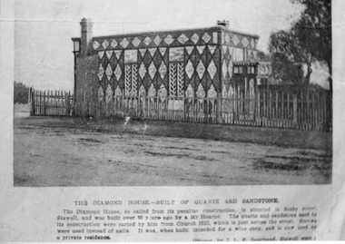
Photograph, Diamond House
Diamond House Stawell Built by John HearneThis is a Photograph of the Diamond House, corner of Seaby and Princes Streets. It's almost as old as Stawell. Built by Mr John Hearne. Brown and White stones that were gathered from Church Hill were cut and carefully fitted to from Diamonds.Black and White Photograph of a very unusual home built in a pattern of Diamonds, in shades of stones. 7 different photos, Various years (1 Coloured)The Diamond House-Built of quartz and sandstone. the Diamond House, so called from its peculiar construction, is situate in Seaby Street, Stawell. and was built over 30 years ago by Mr. Hearne. The quartz and sandstones used in its construction were carted by him from Church Hill, which is just across the street. Screws were used instead of nails. It was when built intended for a wine shop and is now used as a private residence. stawell -
 Stawell Historical Society Inc
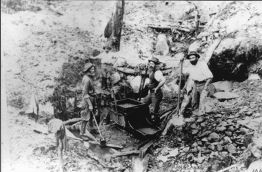
Photograph, Mining Scene at Quartz Reefs, St Georges Lead. Three miners with a gold rocking cradle
Miners around Big Hill area at work St Georges Lead c 1860's. Note gold rocking cradle. This photo was amongst several mining photos, all of which were identified and catalogued under their correct mine name in 2010-2011.Three men with shovels around a gold mine cradle on a rocky hill side.stawell -
 Stawell Historical Society Inc
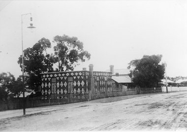
Photograph, Diamond House
Diamond House Stawell. This unique house was built by John Hearne between 1866-1868 using white quartz stone gathered on Church Hill opposite. Mr. Hearne showed considerable skill and patience in construction as the stones had to be carefully cut & fitted into uniformity which has lasted 130 years. Its is said not a nail was used. It became the Diamond house restaurant in 1932. The photo was taken in 1903.Two Black & white photograph of Diamond House including neighboring houses. There is a light post on the left hand side and what appears to be a dirt road in front of the houses. Photo taken in 1903.stawell -
 Stawell Historical Society Inc
Photograph, Scotchmans United Quartz Mining Company Scene c1890's. Same as 2640
Scotchmans United Quartz Mining Company Shaft was 1,018 feet deep.Stawell Mining Scene from Big Hill. Close up view of the winding engine shed Poppet Head and Building Scotchman's United Mine. Rear poppet head Crown Cross. Upper Main Street visible left Back of Photo. Stawell 176 Miles from Melbournemining, panorama -
 Ballarat Heritage Services
Photograph, Dorothy Wickham, Gold Monument, Ballarat, c2010
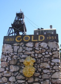
Gold was discovered in Ballarat in 1851 when many people rushed to the diggings. A monument commemorates the centenary of the finding of gold at Poverty Point and is dedicated to the memory of pioneer miners of Ballarat. It records gold yields, nuggets and the richest recorded yields of both alluvial and quartz mines. The replica gold nugget on the monument is the `Welcome Nugget`, found in Ballarat in 1858, weighed 2,217 ounces and was sold for £10,500. The memorial, known as the Pioneer Miners’ Monument, was made to commemorate Ballarat's gold centenary. It was proposed that part of the Pioneers' Memorial Fund might be used. This fund was started with £1300 profit from the 1938 centenary celebrations. (Age (Melbourne), The monument was created by John Edward Skilbeck, a toolmaker with Ronaldson and Tippett. John Skilbeck had a deep interest in Ballarat History, and undertook much research with Bert Strange and Keith Stacpoole. Councilllor William Ernest Roff provided the copper for the memorial from scrap copper obtained during his plumbing business. The copper was reworked by John Skilbeck, and was soldered in the kitchen of his home at 14 Frank Street. Colour photograph of the gold monument on the corner of Sturt Street and Albert Street, Ballarat. It commemorates the discovery of gold at Poverty Point in August 1851, and was The monument was unveiled in 1951 and is mainly constructed of large piecesof quartz, with a miniature popper head on the top made of copper. Mounted on the side is a replica of the Welcome Nugget, which was unearthed on the corner of Humffray and Mair Streets, Ballarat on 09 June 1858.FRONT This monument was erected by the Ballarat Historical Society to commemorate the finding of gold at Poverty Point 21st August 1851 and is dedicated to the memory of/ pioneer miners of Ballarat LEFT SIDE Richest recorded yields alluvial mines Band of Hope 303269 Ozs Prince of Wales 168929 Koh I Noor 164157 Great Redan Ex 110111 Albion 107125 Bonshaw Fr 96520 Park 94699 St George 86702 Sir Wm Don 76830 Hand in Hand 76830 Sir Henry Loch 43562 Quartz Mines Star of the East 256758 Ozs Band of Hope 158299 Victoria United 152013 N Woah Hawp 129562 New Normanby 127562 Britannia 103225 Llanberris No 1 100533 Black Hill 91665 Last Chance U 83766 Llanberris 71364 Speedwell 66000 South Star 64444 Sulieman Pasha Companies 62666 RIGHT Recorded gold yield 20606000 ozs Nuggets Alluvial Welcome 2217 ozs Saraha Snads 1619 Lady Hotham 1177 Canadian 1 1117 Canadian 2 1011 Koh 1 Noor 834 Eureka 625 Lady Loch 617 Prince of Wales 606 Bakery Hill 571 Native Youth 540 Faboulous yields of earliest diggings not offically recorded Quartz Nuggets N Woah Hawp 5-- 300 200 Ozs White Horse 500 Woah Hawp 444 266 262 Canton 257 200 Q Victoria lease 410 U Black Hill Coy 315 Tinworths 250 Parade Coy 245gold monument, ballarat, skilbeck, poppet head, j.e. skilbeck, john skilbeck -
 Ballarat Heritage Services
Photograph - Image - Black and White, Old Works, Black Hill Gully, Ballarat, c1904, c1904
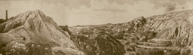
The first company to make a success of hard-rock (quartz) gold mining at Black Hill was the Black Hill Company, formed in 1859. Mining from the open-cut mine probably commenced in 1860 and by 1861 the company had erected the largest stamping mill in Victoria. The mill ran 24 hours a day until the end of 1864 and 12 hours a day in 1865. Open cut mining then ceased. Underground ore extraction continued at Black Hill until the early twentieth century.Photographic image of the abandoned open-cut mine at Black Hill, Ballarat, c1904 ballarat, black hill, mining, open cut, gold -
 Ballarat Heritage Services
Photograph - Photograph - Colour, Corner of Vickers Street and Albert Street, Sebastopol, 2020, 07/04/2020
The South Star Mine commenced operations in the 1880s and worke the quartz laods after the great floods of 1875 forced the closure of most alluvial mines. The South Star Mine sunk its first shaft in 1886, but broke into old alluvial workings and had to be abandoned because of flooding. The second shaft commenced in 1887, and was the deepest eer sunk in the Ballarat district, reaching 956 metres. 180 men worked three shifts each day.Colour photograph of the site of the South Star Mine in Sebastopol. sebastopol, albert street, south star mine, mining -
 Ballarat Heritage Services
Booklet, Golden Plains Heritage Study Stage 2
A study into the Heritage of Golden Plainsgolden plains, heritage, bannockburn, lethbridge, linton, meredith, rokewood, scarsdale, shelford, croindhap, inverleigh, smythesdale, steiglitz, berringa, cape cear, woodbrook homestead, shellford, mcmillans bridge, jubilee company quartz mine, glenfine homestead, werneth, laurence park homestead, darriwil park house, naringal private cemetery, batesford, happy valley, ross creek, wallinduc, maude, murgheboluc, clyde company station, wurrook homestead, lullote homestead, geringhap, moorabool, burunah plains, nintingbool -
 Ballarat Heritage Services
Photograph, Mullock Heap In Victoria Park, Ballarat, 2014, 04/11/2014
The large mullock heap, marks the site of a former quartz mine, and is one of the few visible signs of the former presence of extensive gold mining activities in this area of Ballarat. Originally known as Park Mine, and now known as Mount Holled Smith, the mine associated with this mullock heap puddled 750 tons of washdirt each day. The mine closed down in 1874, at which time 94,699 ounces of gold had been removed from the ground. Colour photograph of a mullock heap in Ballarat's Victoria Park.mullock heap, ballarat gardens, victoria park, park mine -
 Ballarat Heritage Services
Photograph - Photograph - Colour, Steele's Pioneer Mine Ruins, Yandoit, 2016, 18/01/2016
Steele's Reef was opened in 1859 along with a number of other reefs in the Yandoit area. The reef was worked by small mining parties until the late 1880s. In 1887, the Steele's Reef Quartz Mining Company fixed steam pumping machinery and commenced sinking a shaft. The company were unable to find a profitable ore body and after two years work closed down. By this time their shaft had reached a depth of 150 feet. The mine was then taken over by the Pioneer Quartz Mining Company who appear not to have worked the mine. In 1906, the Steele's Pioneer Company commenced work, erecting a winding winch at the old shaft sunk by the Steele's Company. The next year the company erected a 10-head battery, set of poppet legs, a pumping engine. Sinking the shaft a further 100 feet, the company struggled to find payable ore and soon closed down.Colour photographs of the remnants of Steele's mine at Yandoit, Victoria. steele's mine, yandoit, mining, ruins -
 Ballarat Heritage Services
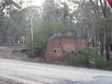
Photograph - Colour, Clare Gervasoni, Thornhill Reef Quartz Roasting Kilns, 2017, 17/10/2017
Colour photographs of the Thornhill Reef Quartz Roasting Kilns in the Muckleford State Forest.muckleford state forest, goldfields, mining -
 Bendigo Historical Society Inc.
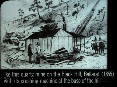
Slide - DIGGERS & MINING. DIGGERS AND MINERS, c1855
Diggers & Mining. Diggers and miners. Like this quartz mine on the Black Hill, Ballarat (1855) with its crushing machine at the base of the hill - - - Slide: Shows dwellings one made from timber with chimney, one made from canvas, with a veranda and what appears to be a round metal chimney. 2 men in the for ground have some timber and could be contemplating a timber dwelling. There are a couple of other dwellings in the background. Not many trees left on the hill. Markings: 26 994:LIF I. Used as a teaching aid.hanimounteducation, tertiary, goldfields -
 Bendigo Historical Society Inc.
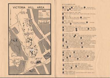
Map - VICTORIA HILL AREA
Map of Victoria Hill Area printed on yellow paper. Details of tracks, cuttings, contours (in Metres) and Anticline. Location of mines, open cuts and buildings are shown. Numbers on map are: Ballerstedt's Claim 1 - 5; North Old Chum Co. 6; Lansell's 180, 7,8,11; Battery 9.10.12; Victoria Quartz Co. 13 - 17; Rae's Open Cut and Vicinity 18 - 28, Great Central Victoria Co 29 - 36, Adventure and Advance Area and vicinity 37 - 40 and Victoria Consols Co 41.map, bendigo, victoria hill, victoria hill area, victoria consols, new chum anticline, great central victoria, rae's open cut, w rae's home, victoria quartz, ballerstedt's open cut, lansell's 180, north old chum, central nell gwynne, john brown factory, gold mines hotel, cleopatra needle type chimney, floyd's battery, ballerstedt's 24yd claim, humboldt shaft, wittscheibe's jeweller's shop, luffsman and sterry's claim, victoria hill reserve, mines dept reervation -
 Bendigo Historical Society Inc.
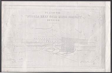
Document - VICTORIA REEF GOLD MINES COMPANY BENDIGO PLAN
Photocopy of a Plan of the Victoria Reef Gold Mines Company, Bendigo. Shaded area is the Victoria Reef Gold Mines Company Lease No. 2 and Lease No. 3. The gullies are named Happy Valley, Long, Derwent, Providence and Ironbark Gullies. The reefs are: Western Victoria, Victoria, Eastern Victoria and Prince Albert Reef. Between the Eastern Victoria Reef and the Prince Albert Reef is the White Lead. Mount Korong Road is at the bottom of the plan. Other Leaseholders are: Burrows, Wybrant, Ballerstedt, Jackson,Roberts & Co, Ashley, Grant, ?rpe, ?eau, Woodward, Coath, Taylor, Cranshaw, Roberts, Gould & Co, Midway, Witscheibe, Endeavour Co, Albert Co, Ballerstedt & Son, Late Iron Bark Quartz Mining Co, McDougall, Specimen Hill Co, Hygrect?, Wheadon, Evans and Bannerman. Signed by H. B. Nicholas. Location of Ballerstedt, Luffsman, Midway Co, Witscheibe and Rae & Co engine locations. Hills are shown as hatch shading. Written at the bottom left ocrner is: Accompanying prospectus issued in Nov. 1859. Signed H.B. Nicholas.plan, bendigo, victoria reef gold mines company, victoria reef gold mines company bendigo - plan, h b nicholas, burrows, wybrant, ballerstedt, jackson, roberts & co, ashley, grant, ?rpe, ?eau, woodward, coath, taylor, cra-shaw, roberts, gou-d & co, midway, witscheibe, endeavour co, albert co, ballerstedt & son, late iron bark quartz mining co, mcdougall, specimen hill co, hyo?, wheadon, evans, bannerman. -
 Bendigo Historical Society Inc.
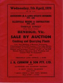
Document - IAN DYETT COLLECTION: AUCTION CATALOGUE - ANDERSONS (R.G. LONG) QUARTZ CRUSHING ALLENDALE
Three red covered auction catalogues for a sale on the 7th April, 1976 at Andersons (R. G. Long) Quartz Crushing Pty. Ltd. And Allenvale Mining & Contracting Pty. Ltd., Bendigo. Crushing and Quarrying Plants. For sale were Corr. Iron building, excavators, front end loaders, electric crane on Chev. 6 x 6 truck, compressors, tip trucks, primary and secondary crushers, electric motors, elevators, steel workshop and general plant and equipment. Also approx. 3/4 acre Freehold land. J. H. Curnow & Son Pty. Ltd. Were the auctioneers.business, auctioneers, j h curnow & son pty ltd, ian dyett collection - auction catalogue - andersons (r. g. long) quartz crushing pty. ltd, allenvale mining & contracting pty ltd, j h curnow & son pty ltd, f c dyett, c hill, i m dyett, bolton bros print -
 Bendigo Historical Society Inc.
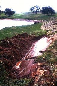
Slide - Dunn's Rock Eppalock, 2012
The low rolling hills of the Kimbolton countryside consist of ancient, hard and fractured Ordovician rock up to 65 million years old, which was originally deposited deep under the sea. Rocks mainly are sandstone, mudstone, black shale and quartz conglomerates. Marine fossils can be found in the area. Around seven million years ago a basalt flow buried the original bedrock along the along the Campaspe River. Ongoing weathering, wind and water movement over the following years has produced younger clay, sand, silt and gravel deposits throughout the area. Patches of White Hills Gravel are also found in the area. Another unique geological feature of this area is the Permian Glacial Pavement rocks north and south of Eppalock and glacial sediments (such as “Dunn’s Rock” and “Kellams Rock”). During the ice age (up to 280 million years ago) large glaciers moving over the countryside, scoured out sediments, pulverized bedrock, polished and cut grooves into bedrock in the direction of ice movement. When the ice melted boulders etc where left behind in areas of entirely different rock types, such as a 100 Tonne granite block known as ‘The Stranger’ near Derrinal. Dunn's Rock (Glaciated Pavement) Eppalock - Photos of the rock and a field group collecting date with Lake Eppalock (Knowsley) in the backgroundhistory, bendigo, dunn's rock eppalock, kimbolton forest, lake eppalock, gately collection -
Bendigo Historical Society Inc.
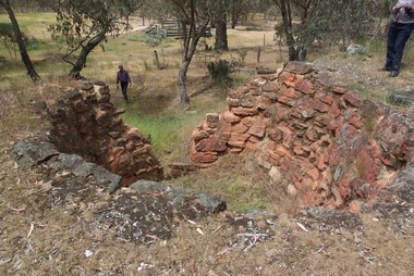
Booklet - Victoria Hill
Victoria Hill, accessed from Marong Road, was one of the richest areas on the Bendigo goldfields and was the beginning of reef mining as opposed to alluvial mining. Between 1853 and 1861 there were 16 claims registered on Victoria Hill. Between 1908 and 1910 it was the site of the world's deepest shaft (1365-1406 meters)Today it provides interpretive walks that include sites such as an open-cut mine (1850's), poppet head, quartz crushing battery (1930's) and the foundations of George Lancell's 180 mine. It is registered as a site of historical significance.Clear plastic cover spiral bound booklet of 25 pages. 'Victoria Hill'. A historical background of Victoria Hill and the surrounding area. A colour photo of a poppet head on front. Original story written by Albert Richardson in 1971. This is a revised edition by Philip Wilkin in 2012. Illustrated with colour and B&W photos. Pages 13 to 25 have been inadvertently inserted upside down. A single page A4 leaflet 'Victoria Hill Self Guided Tour' has been put inside after page 1Handwritten in ink on front page 'Donated to Specimen Cottage'victoria hill, gold mine -
 Bendigo Historical Society Inc.
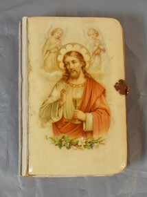
Book - German Bible
There was a large influx of German miners to the Bendigo gold fields and they mainly focussed on deep quartz mining. German enclaves existed at Diamond Hill, New Chum Gully, Victoria Hill, Ironbark and in the Whipstick area. The first Lutheran Church was built in 1865 and there were also two German schools. Small bible with hard cover, possibly bakelite/plastic. The cover has an image of Jesus with and angel above each of his shoulders and plants at the bottom of the image. Pages of bible have gold edging. There is a metal clasp to lock. The back is plain and a creamy color.german, bible, religion -
 Bendigo Historical Society Inc.
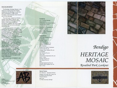
Pamphlet - MERLE HALL COLLECTION: ROSALIND PARK CREATIVE VILLAGE BENDIGO PROJECT PAMPHLET, 1995
Merle Hall Collection: Rosalind Park Creative Village Bendigo Project Pamphlet for Rosalind Park Lookout - two copies. One side of the pamphlet has a layout image of the five sections of the mosaic and the poppet head base. The sections are numbers 1 to 5 Section 1: A stylised representation of the main Bendigo Goldfield based on a geological plan (Publish in 1992). It shows the lines of reef, including the famous Hustlers, Garden Gully and New Chum. Section 2: A typical cross section of the Bendigo Goldfields Section 3: The mine layout shown in this design features part of the Garden Gully line of reef. Section 4: Shown here is the Iron Bark mine on the Sheepshead reef. It has an interesting pattern of drives, stopes and winzes. Section 5: In this section the artist uses gold as her inspiration. The larger mosaic shows quartz veins winding through the earth containing gold in its various forms. The smaller mosaic represents the atomic structure of gold. It shows the the nucleus, the six shells of the atom, their electrons and orbits. The other side of the pamphlet describes the background of the community arts project, the artist, and volunteer workers, also notes mentioning the Bendigo community history. It also lists the donors for funding and business's that supported the project, with special thanks to Eric Wilkinson - Geolpogical advoser, the students and staff from Camp Hill, St Killians and Violet Street primary schools. BRIT and La Trobe University, bendigo. -
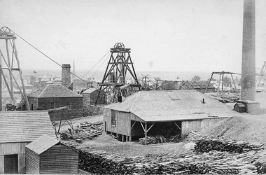
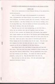
![View of Victoria Hill, Bendigo, taken from Old Chum Hill / [by] Nicholas Caire, circa 1876](/media/collectors/550653872162f11fb04854aa/items/577752a3d0cdd10a5c16e654/item-media/57775308d0cdd10a5c171c46/item-fit-380x285.jpg) Kew Historical Society Inc
Kew Historical Society IncPhotograph, Anglo-Australasian Photographic Company, View of Victoria Hill, Bendigo, taken from Old Chum Hill, c. 1876
Nicholas Caire was born on Guernsey in the Channel Islands in 1837. He arrived in Adelaide with his parents in about 1860. In 1867, following photographic journeys in Gippsland, he opened a studio in Adelaide. From 1870 to 1876 he lived and worked in Talbot in Central Victoria. In 1876 he purchased T. F. Chuck's studios in the Royal Arcade Melbourne. In 1885, following the introduction of dry plate photography, he began a series of landscape series, which were commercially successful. As a photographer, he travelled extensively through Victoria, photographing places few of his contemporaries had previously seen. He died in 1918. Reference: Jack Cato, 'Caire, Nicholas John (1837–1918)', Australian Dictionary of Biography.An original, rare photograph from the series 'Views of Victoria: General Series' by the photographer, Nicholas Caire (1837-1918). The series of 60 photographs that comprise the series was issued c. 1876 and reinforced a neo-Romantic view of the Australian landscape to which a growing nationalist movement would respond. Nicholas Caire was active as a photographer in Australia from 1858 until his death in 1918. His vision of the Australian bush and pioneer life had a counterpart in the works of Henry Lawson and other nationalist poets, authors and painters.Albumen silver photograph on boardprinted in ink on support l.c.: VIEW OF STURT STREET, BALLARAT, TAKEN FROM THE TOWN HALL TOWER. / COPYRIGHT REGISTERED. printed in ink on support reverse c.: VIEWS OF VICTORIA. / (GENERAL SERIES.) / No. 13. / VIEW OF VICTORIA HILL, BENDIGO, TAKEN FROM OLD CHUM HILL. / This scene represents two of the principal Quartz-reef claims in the district of Bendigo, with their surface / excavations. The one nearest the foreground is the North Old Chum's Company's claim, which is very rich with / gold-bearing quartz. The other claim, on the hill side, is the private property of Mr. George Lansell, and is even / more valuable than the former, giving employment to over 100 men. The building on the right is the quartz-crushing / plant belonging to the new Chum and Victoria Companies. The excavations are several hundred feet in depth. printed in ink on support reverse l.c.l.: J.W. FORBES, Agent, printed in ink on support reverse l.c.: ANGLO-AUSTRALASIAN PHOTOGRAPHIC COMPANY, MELBOURNE. printed in ink on support reverse l.c.r.: 10 Temple Court, Collins Street West.nicholas caire (1837-1918), landscape photography, victoria hill - bendigo - victoria -
Bendigo Historical Society Inc.
Document - MINING IN BENDIGO COLLECTION: NAMES OF MINING SLIDES
BHS CollectionTyped copy and two handwritten copies of index to mining slides per Bob Aulsbrook, 30.12.69 and Ian Hendry.document, gold, mining in bendigo, mining in bendigo, names of mining slides, bob aulsbrook, ian hendry, new chum railway, healthy golden bendigo, lansells 222, lansell's fortuna, old chum mine, from new chum hill, to victoria hill, plan of leases on victoria hill 1859, lansell's big 180, bendigo & vicinity, victoria quartz, wm rae's crushing machine, hercules & energetic, mungo mines, united devonshire, mungo group & devonshire mines 1888, catherine reef united, garden gully united, knipe;s castle, old carlisle, nth garden & passby, koch's pioneer quartz crushing battery, great northern mine, virginia mine, specimen hill, new argus, south new moon, new moon, big blue mine, eadie's whim & central blue mine, fortuna hustlers, pictorial photos of victorian views, hustler's royal reserve mine - city, extended hustler's freehold - looking south, great extended hustlers, hustlers reef mine, central nell gwynne, cornish boiler, lancashire boiler, wannan's e'drivers guide, winding engine - new moon, 20 drill air compressor - new moon 1904, engine at virginia crushing battery, lansell's 105 head crushing battery, deeble's pyrites works, miner at central deborah, level at 1045 feet at new moon, boring on a reef at catherine reef, deborah mine 1000 ft level, mines dep't melb & bendigo, engine beds lansell's big 180, new hustlers, rae's open cut, ballerstedt's first open cut, 3 of early days of bendigo, geo lansell -
 Eltham District Historical Society Inc
Photograph - Digital Photograph, Alan King, Panton Hill Hotel, 27 March 2008
Today’s Panton Hill Hotel was built around 1920. Published: Nillumbik Now and Then / Marguerite Marshall 2008; photographs Alan King with Marguerite Marshall.; p61 Panton Hill was originally known as Kingstown, and consisted of only one hotel when the Orams Reef was discovered in 1859. Kingstown was a quartz mining centre and many old mine shafts remain in the area. Orams Reef was one of the first reefs with a rich find of gold in the area. The Hotel Francais, which had been operating in 1861, was well situated on the way to Queenstown (later St Andrews). So was Herr Hirt’s Hotel and store at Smiths Gully. The Kingstown hotel, known as the Frenchman’s and in 1864 as the Hotel de France, was run by a Monsieur Emile Hude and his wife Jeanne, and known for its good food. They hosted social events, business conventions and debates, attracting patrons from as far as Melbourne. The hotel’s name was changed to Panton Hill Hotel in 1905. In 1883 Charles Caudwell built another hotel nearby, possibly in Long Gully Road,3 which it is thought, was burnt down early last century. Today’s Panton Hill Hotel, built around 1920, is the only one of the cluster of buildings in the main road, not to date from around the turn of last century. It was severely damaged by fire in 2003, then underwent extensive alterations. It is the township’s only hotel and is an example of a modest hotel building exterior, constructed early last century. In its early days the hotel also housed the first post office, newsagency and store. Orams Reef yielded a total of £100,000, and fossikers also found alluvial gold in the creeks and gullies, but there is no record of the total value of their finds. Gold greatly increased the Panton Hill population, which peaked between 1865 and 1885. On holidays large sports meetings were held with wood chopping contests and foot races and the day would end with a ball. Miners came from various countries to seek their fortune, including many from China. The Chinese became unpopular however, and gradually left the district, although some stayed and grew and sold vegetables.5 Panton Hill was named after Joseph Panton, who in 1862 was appointed Police Magistrate for the Woods Point, Heidelberg and Yarra districts. Panton was an outstanding man, who in 1852, was Commissioner of Crown Lands and Assistant Commissioner of Goldfields at Bendigo. In 1874 he was promoted to Chief Magistrate for the Melbourne Police. Panton was also an artist, becoming president of the Victorian Arts Society in 1888, and in 1913, president of the Royal Geographical Society. Despite Panton Hill’s prosperity, it still lacked many services as poor roads made access to Melbourne difficult. A horse-drawn mail coach travelled to Melbourne until 1890, when the railway came to Heidelberg. The nearest doctor was at Yarra Glen or Heidelberg, and the Indian hawker Singh’s annual visit was very welcome. A miner’s shack opposite the school was used as a post office. Today’s general store and post office in the main road dates from early last century, and has changed considerably. While most people searched for gold, the more enterprising ones established farms to feed the diggers. Farmers grew wheat, barley and oats, and sent animal skins to the Eltham tannery, to make furs in Melbourne. As gold became scarce from around 1880, miners took up farming on 19 to 20 acre (8ha) allotments. The first settlers in Cherry Tree Road included Purcell, Smith, Owens, Hughes and Shillinglaw. By 1900 all the land had been taken up around Panton Hill and Hurstbridge. The orchards in Panton Hill and the wider district, particularly of apple and pear, were very successful, and made Panton Hill a cohesive and successful community. About 1914 the Moores built the first cool-store and refrigeration plant at their orchard in Cherry Tree Road. Many settlers planted vineyards and made high quality wine, but in 1922 the blight destroyed them.This collection of almost 130 photos about places and people within the Shire of Nillumbik, an urban and rural municipality in Melbourne's north, contributes to an understanding of the history of the Shire. Published in 2008 immediately prior to the Black Saturday bushfires of February 7, 2009, it documents sites that were impacted, and in some cases destroyed by the fires. It includes photographs taken especially for the publication, creating a unique time capsule representing the Shire in the early 21st century. It remains the most recent comprehenesive publication devoted to the Shire's history connecting local residents to the past. nillumbik now and then (marshall-king) collection, panton hill hotel -
 Eltham District Historical Society Inc
Photograph - Digital Photograph, Marguerite Marshall, One Tree Hill Mine, Smiths Gully, 8 June 2006
Gold was discovered on One Tree Hill in 1854. The site has been worked intermittently until fairly recent times. Published: Nillumbik Now and Then / Marguerite Marshall 2008; photographs Alan King with Marguerite Marshall.; p53 Though still a working mine, One Tree Hill Mine at Smiths Gully, now stands in a tranquil reserve surrounded by bush and native animals - in contrast to its heyday. In the mid 19th century, when the mine was part of the Caledonia Goldfields, hundreds of men in search of their fortune worked the alluvial gold in the Yarra River, its tributaries and the reefs that made up the goldfields. Miner Stan Bone, assisted by Wilfred Haywood, is the last of the independent gold miners in the area and still uses the quartz crushing battery as miners did when gold was first discovered in the area in 1851.1 Stan, who is the last of six generations of miners in his family, was aged 17 when he began mining on his father Alex’ mine, The Golden Crown in Yarrambat. These days, after blasting the gold-bearing rock in Mystery Reef, one of the four reefs at One Tree Hill, Stan transports it around five kilometres by tip truck to the Black Cameron Mine for crushing. There he uses water from the waterlogged mine, (which still contains gold), as the Happy Valley Creek at One Tree Hill is usually dry.2 The One Tree Hill Mine has been worked for close to a century since it opened around the late 1850s.3 The Swedish Reef was its most productive reef and one of the largest in the area. Around 1859, extractions included 204 ounces (5.8kg) of gold, won from 57 pounds (26kg) of stone.4 Then during World War Two, Stan’s uncle, Bill Wallace, and Alex Bone, closed the mine. In 1973, Stan, with his Uncle Bill, reopened the Black Cameron Mine and worked there until 1988. Stan resumed mining One Tree Hill in 1998. As late as the 1920s gold was picked up by chance! When crossing a gully on his way to vote at the St Andrews Primary School, Bill Joyce picked up some quartz containing gold. This site was to become the Black Cameron Mine. The Caledonia Diggings, named after Scotland’s ancient name by local Scots, began around Market Square (now Smiths Gully) and included Queenstown (St Andrews), Kingstown (Panton Hill) and Diamond Creek. There were also poorer bearing fields in Kangaroo Ground and Swipers Gully (now Research). * None of these compared in riches to the Ballarat and Bendigo fields5, but the Caledonia Diggings continued intermittently for close to 100 years. Gold was discovered in Victoria following a bid to stem the disappearance of much needed workmen to the New South Wales diggings. Several businessmen offered a reward of £200, for the discovery of gold within 200 miles (322 km) of Melbourne. Late in June 1851, gold was first discovered at Andersons Creek, Warrandyte. Then in 1854, George Boston and two other men discovered gold at Smiths Gully. Gold transformed the quiet districts, with a constant flow of families and vehicles on the dirt tracks en route to the Caledonia Diggings. Three thousand people worked the gullies in Market Square, including about 1000 Chinese miners. The square established its own police, mining warden, gold battery, school, shops and cemetery and grog flowed. Market Square flourished until the middle 1860s. Bullocks transported quartz from the Caledonia Goldfields to the crushing machinery at the Queenstown/St Andrews Battery, near Smiths Gully Cemetery. It was destroyed by bushfire in 1962. By the late 1850s, most early alluvial fields were in decline, but minor rushes continued until around 1900 and some until the early 1940s. Some miners did well, although most earned little from their hard labour in the harsh and primitive conditions.6 But according to historian, Mick Woiwod, the gold fields helped to democratise society, as individuals from all walks of life were forced to share experiences, and the ability to succeed, depended less on inherited wealth or social rank.This collection of almost 130 photos about places and people within the Shire of Nillumbik, an urban and rural municipality in Melbourne's north, contributes to an understanding of the history of the Shire. Published in 2008 immediately prior to the Black Saturday bushfires of February 7, 2009, it documents sites that were impacted, and in some cases destroyed by the fires. It includes photographs taken especially for the publication, creating a unique time capsule representing the Shire in the early 21st century. It remains the most recent comprehenesive publication devoted to the Shire's history connecting local residents to the past. nillumbik now and then (marshall-king) collection, gold mining, one tree hill mine, smiths gully -
 Eltham District Historical Society Inc
Photograph - Digital Photograph, Alan King, Site of the Diamond Creek Gold Mine, 28 December 2007
The largest gold mine in the area originated from a find in 1862. The mine was closed January 20, 1915 when a fire destroyed nearly all the above ground plant. Published: Nillumbik Now and Then / Marguerite Marshall 2008; photographs Alan King with Marguerite Marshall.; p75 Beneath Mine Hill, as locals call it, runs a network of tunnels once of central importance to the fledgling township of Diamond Creek. These are relics of gold mines, which transformed early Diamond Creek.1 The tiny settlement of about 20 families soared to more than 200 because of gold. For around 50 years, from 1862, gold mining was Diamond Creek’s major source of employment. On September 7, 1854 The Argus newspaper reported a find of a four pound (1.8kg) gold nugget in Nillumbik (an early name for Diamond Creek). Exactly where, is not known.2 The largest mine in the district, the Diamond Creek Gold Mine, apparently originated from a find in 1862. It is said Joe and Dave Wilson were visiting former tailor then cook, Charles Orme, at the southern end of Fraser Street. Sitting on a stump outside the front gate on land belonging to Dr A. E. Phipps the Wilsons found a vein of gold-bearing quartz, which led to the discovery of four quartz reefs varying in width to eight inches (20cm), running north and south. A reef found at the foot of the hill opposite Challenger Street became the Union Mine. This reef was traced south to Allendale Road where a small mine began operations.3 Other smaller mines later operated as well. Dr Phipps immediately began to mine and also built the Diamond Reef Hotel as a boarding house for miners. But Charles Orme, who owned the land alongside, leased his mine to Dr Phipps probably because of insufficient funds and business skills. By mid 1865 the mine had produced 2530 ounces of gold – a 100% profit on the original outlay. Of course there were problems. When the local dam dried up a Blake pump was installed to draw water from the creek. The Union Mine operated under the Diamond Creek Gold Mine management except when disputes sometimes resulted in separate management. However disagreements had to be resolved as the Union Mine depended on Diamond Creek Gold Mine pumps to remove underground water from common reefs. In 1912 the main shaft of about 380 yards (350m) employed 200 men recovering an average of 5000 ounces (141.7kg) of gold a year. But not everyone did well out of gold. Records of failed mining companies in the Victorian Public Record Office, reveal that owner Dr Phipps leased his Right to others. Companies came and went over the next 40 years, most sponsored by Melbourne businessmen who sold shares to gullible locals and then became insolvent. Although there were some good profits, financial returns were haphazard until 1905. Some local residents, who were share holders in short- term companies, became well-known names in modern Diamond Creek such as Scott, Haley, Butler, Alder, Ryan, Wadeson, Reeves, Alston, Paul and Edwards. Gold mining was brought to a disastrous end on January 20, 1915 at 3 pm, when fire destroyed nearly all the above-ground plant. Fortunately no lives were lost. But reopening the mine was almost impossible because of the increasing depth of water in the main shaft. The closed mine destroyed the livelihood of 200 families and the debris took many years to clear.4 In 1946 the Diamond Creek Gold Mine was reopened by the Golden Hind Mining Company, but money ran out before the 600 feet (182.8m) or so of water could be removed. Gold remains in the mine but enormous capital would be needed to buy the land, equipment and to remove the water. Today 12 known sealed shafts along the ridge of the hills on private property extend west for around one kilometre from the corner of Fraser and Haley Streets, crossing Norma and Fyffe to Dering Streets. As recently as 1987, heavy rains revealed a former Union Mine shaft in the Georgiadis family Fyffe Street back yard.5 Allendale Mine, south of Allendale Road, is still open and one of the Union Mine’s main drives (horizontal excavation) remains unsealed, on the Creek Reserve.This collection of almost 130 photos about places and people within the Shire of Nillumbik, an urban and rural municipality in Melbourne's north, contributes to an understanding of the history of the Shire. Published in 2008 immediately prior to the Black Saturday bushfires of February 7, 2009, it documents sites that were impacted, and in some cases destroyed by the fires. It includes photographs taken especially for the publication, creating a unique time capsule representing the Shire in the early 21st century. It remains the most recent comprehenesive publication devoted to the Shire's history connecting local residents to the past. nillumbik now and then (marshall-king) collection, diamond creek, diamond creek mine, fraser street, gold mining, james cook drive, mine hill -
 Bendigo Historical Society Inc.
Document - TRANSCRIPT OF TAPE: JOHN HATTAM, August 1982
Transcript of Tape - 16 pp. by John Hattam narrated to Mrs Phyllis Smithson, August 1982 (as part of Oral History assignment). Filed under Jack Hattam (Memories of). Within H.John O'Connell Hattamjohn hattam, thomas hattam, st. just point, long gully, o'connells, victorian quartz mining company, great eastern, white hills, st matthew's church, st killian's school