Showing 134 items
matching scales e.
-
 Federation University Historical Collection
Magazine - Booklet, Ballarat School of Mines, Student Magazine, Fourth Term, 1910, 1910
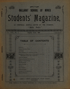
Table of Contents: Editorial, Rotary converter notes, Ambulance, Slime treatment for attraction of gold, Description of slime settler or dewaterer in use at the Brownhill Consols mine Kalgoorlie, Transvaal geology, Chlorine produced electrolytically, Scaling of copper plates, The eucalyptus, Sports meeting, Rowing, Past students, News and notes, Answers to correspondents, Editorial notices. Images.Magazine of 24 pages. Page 17 lists the whereabout of past Ballarat School of MInes students: J.R. Booth, W.t. Lakeland, Lewis Westcottm Leo M. Seward, Reginald Williamson, Stanley White, Clyde Allan, Charles Lamb, W.E. Eyres, Virgil Tucker, H. Hawkesworth, H.J. Saw, Fred G. Brisnden, C. Stevenson, Fred Treloar, J. Peart, E.M. Weston, Dick Galloway, H.B. Bennetts, G.R. Curry, H. Meadows, Eric Bieske, Cliff Garrard, Phil Brown, Lindsay D. Cameron, Phil Brown,, W.P. Avery, J. Foster, J. Bickett, F.H. Inglis, G. Devenport, t. lennon, h. wilkins, g.h. reid, c. hesselman, E. Fraser, Reginald Callister, F. Bicknell, Leslie Blick, W.T. Sayer, W.F. Hall, O.e. Jaeger, W. Gelard, P.C. Downes, G. Sides, F. Bruce, Frank Bruce.rotary converter, ambulance, slime treatment for attraction of gold, slime settler or dewaterer, brownhill consols mine kalgoorlie, transval geology, chlorine produced electrolytically, scaling of copper plates, eucalyptus, alumni, rollo e. huntley, j.r. booth, w. t. lakeland, lewis westcott, leo m. seward, reginald williamson, stanley white, clyde allan, charles laird, w. e. eyers, virgil tucker, h. hawkesworth, h. j. saw, fred g. brinsden, c. stevenson, fred treloar, j. peart, e. m. weston, dick galloway, h. b. bennetts, g. r. curry, h. meadows, will watson, don cameron, eric bieske, cliff garrard, lindsay d. cameron, phil brown, w. p avery, j. foster, james bickett, f. h. inglis, g. davenport, l. c. courbould, t. lennon, h. wilkins, g. h. reid, c. hesselmann, e. fraser, reginald callister, f. bicknell, leslie blick, w. t. sayer, h. f. hall, o. e. jaeger, w. geldard, p. c. downes, g. sides, f. bruce, e. c. hurdsfield, william baragwanath, r. i. moore, j. l. sampson, h. conran, w. gelard, frederick j. martell, h. cornell, g.c. klug, great fingall consolidated ltd, transvaal geology, eucalyptus gum tree, w.t. lakeland, lewis westcottm leo m. seward, charles lamb, w.e. eyres, h.j. saw, fred g. brisnden, e.m. weston, h.b. bennetts, g.r. curry, w.p. avery, j. bickett, f.h. inglis, g. devenport, g.h. reid, c. hesselman, w.t. sayer, w.f. hall, o.e. jaeger, p.c. downes, frank bruce., mt morgan, kalgoorlie, mt elliott copper mine, ballarat city baths, r.b. young -
 Flagstaff Hill Maritime Museum and Village
Plan - Vessel, Public Works Department (P.W.D.), Matthew Flinders I, 8-11-1911
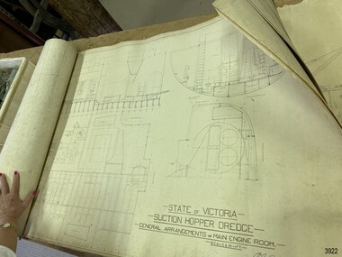
These plans are line drawings by the State of Victoria for a Suction Hopper Dredge, which used a suction pump to bring up material from the bottom of a body of water. The plans are contained in a box from the Public Works Department, Ports and Harbours Division in Melbourne, which in the year 1910 was responsible for the dredging operations of coastal ports and harbours, and inland waterways. The stamped signature is that of Arthur Edward Cutler, Chief Engineer, Public Works Department of New South Wales. The steel steamer Matthew Flinders was constructed by Morts Dock & Engineering Co Ltd in Sydney, New South Wales. Identified as Ship No. 40 by the ship builders, this dredge, had twin screw engines that were made in Sydney. Its gross tonnage was 1180. It was launched on July 15th, 1916, and registered by the owner, Department of Public Works in Victoria, at the Port of Melbourne in 1917. Unlike bucket dredges, the Matthew Flinders did not use permanent moorings but instead had bow and stern anchors. It travelled forward on the bow anchor, taking up a strip of even-depth wilt from the bed below. A local newspaper noted that the Matthew Flinders has many advantages that were especially useful for its work at Warrnambool. Warrnambool Harbour had been experiencing silting and sanding for many years. The problem continued even after the construction of the Breakwater in 1890, which was overseen by New Zealand engineer Arthur Dudley Dobson. Melbourne’s Department of Ports and Harbours sent the new Matthew Flinders to dredge the heavy silting in the Warrnambool Harbour in May 1919. This work was previously done by the smaller dredge, the Pioneer. However, after a month of work, the Matthew Flinders was returned to Melbourne for alterations to make it suitable for work in the heavy seas it experienced at Warrnambool. Both dredges were sent up from Melbourne when required over the years to periodically attend to the silting in the Harbour, but the Matthew Flinders was preferred because of its efficiency. It was still dredging the Harbour even in July 1938. The ship’s original master was J G Rosney. In 1923 the master in charge was Captain Dunbar. In 1930 the dredges were no longer required as the Harbour was no longer suitable as port.These plans are significant for their close association with the suction hopper dredge, the Matthew Flinders I, which was call upon often to remove the silting of Warrnambool Harbour and allow shipping to continue in the Port of Warrnambool until 1930, when the Port of Warrnambool ceased to be suitable as a port. The work done by the Matthew Flinders is significant for its association with the Warrnambool Breakwater and the on-going issues with the silting of the Harbour. Plans with line drawings for the suction hopper dredge Matthew Flinders, rolled, in open-top wooden box. Created for the Public Works Department, Melbourne, Victoria. Stamped with signature and dated November I, 1911. Inscriptions: label on box, handwriting on box, drawings and outer layer of paper. Freighted by 1 Star, New Zealand Express Cargo.Signature stamp “A E Cutler” Date stamp “NOV 8 – 1911” Printed on one page “STATE OF VICTORIA / SUCTION HOPPER DREDGE / GENERAL ARRANGEMENTS OF MAIN ENGINE ROOM / SCALE 1/2 IN = 1 FT.” Label on box "1 [star symbol] / THE NEW ZEALA- - - / EXPRESS CAR - –“ Handwritten on base “PUBLIC WORKS / DEPARTMENT / - - LBOURNE” Handwritten in pencil on cover paper “MATTHEW Flinders”flagstaff hill, warrnambool, maritime village, maritime museum, flagstaff hill maritime museum & village, shipwreck coast, great ocean road, plan, line drawing, dredge, pioneer, steel steam ship, twin screw engines, a e cutler, arthur edward cutler, chief engineer, public works department, new south wales, nsw, 1911, state of victoria, suction hopper, main engine room, public works melbourne, warrnambool harbour, lady bay, sanding, silting, breakwater, morts dock & engineering co ltd, j g rosney, captain dunbar, ship no. 40, matthew flinders i, matthew flinders, 1 star, new zealand express cargo -
 Bendigo Historical Society Inc.
Document - BENDIGO SALEYARDS COLLECTION: LIST OF SUPPLIERS
Two pages of list of suppliers. Page is divided into Five columns - Product, Activity Code, Product Code, Supplier and Supplier No. Products include stationary, hire of equipment, branding pasint, hay, glass, electrical work, repairs, dog food, testing of scales, grinding and cutting wheels. Suppliers were Hi Tech, Hume & Iser, Bendigo Hire, Mettler Toledo, BRB, Abbotts Supply, Dalgety Farmers, Bendigo East Sand and Soil, Bendigo Bearings, Bolton Bros, Fitzpatricks, Bendigo Bolts and Fasteners, CVC, Bendigo Glass Co, Dept Business Employment, DG Walkers, Bendigo Scale Co, Peter Llewellyn, Patches, Bendigo Mower Service, Transcom, Mulqueens Printer, John Truscott, All Bull, Elders Ltd, J H Plant and Son, Surdex, Obriens Glass, W C and H M Bury, BOC Gases, Windscreen City, Cleanaway, RJ and E R Conroy, J Blackwood & Sons.bendigo, council, cattle markets, bendigo saleyards collection - list of suppliers, hi tech, hume & iser, bendigo hire, mettler toledo, brb, abbotts supply, dalgety farmers, bendigo east sand and soil, bendigo bearings, bolton bros, fitzpatricks, bendigo bolts and fasteners, cvc, bendigo glass co, dept business employment, dg walkers, bendigo scale co, peter llewellyn, patches, bendigo mower service, transcom, mulqueens printer, john truscott, all bull, elders ltd, j h plant and son, surdex, obriens glass, w c and h m bury, boc gases, windscreen city, cleanaway, rj and e r conroy, j blackwood & sons -
 Bendigo Historical Society Inc.
Map - CAMPBELL COLLECTION: BENDIGO & DISTRICT MAPS
Map. Lockwood, Parishes of Lockwood and Shelbourne. Scale 20 chains to 1 inch.Total area 4405 acres. Bullock Creek to the right, Spring Creek at Centre. Newbridge is 11 miles N E, To Marong, Bendigo Lockwood roads are on the left. (number 375 in map cupboard 1)map, bendigo, agricultural lands -
 Bendigo Historical Society Inc.
Document - BILL ASHMAN COLLECTION: CORRESPONDENCE
Dull orange folder containing copies of letters, brochures, information sheets and some newspaper cuttings. Name on the front is Frank A. Stevenson 244 Hargreaves St Bendigo. Letters date from 1937 to 1942. Newspaper titles include: Prevention of Rust- Principle of the Scalebuoy, Scalebuoys in Cars, Tragic Death of Captain Hartley Abbott and the Obituary of Captain R.H.S.Abbott.sciences, instruments - general, scalebuoy, bill ashman collection - correspondence, frank a stevenson, mr bacon, amalgamated freezing co bendigo, g whalley, gunbower co-operative butter factory & trading coy ltd, mr wallace, j charlesworth, d v evershed, bendigo electronic co, walshes crown hotel, hunter bros, wybgones unit, 180 gold mining co, o'hallorans cyanide unit, crystal ice works, stevenson unit, bendigo council, central nell gwynne, nth deborugh g m co, deborugh g m c, deborugh consolidated, cohuna butter factory, geo ross, victorian producers' co-operative coy ltd, h abbott, ernest f o liddell, rothacker bros, motor spares ltd, leggo's buildings, t j jorgensen, mr robinson, stevenson bros, r h s abbott, d c house, the electrical factor in metabolism, w n abbott, the great boulder proprietary gold mines ltd, w o galletly, mr stronell, newport workshops, victorian railways, mr brownbill, mr james, the university of melbourne, j l osborne, n clarkson, sister mary gonzaga, st joseph's hospital, mater misericordiae hospital, mr herzog, sister m monica?, vacuum oil, j johns, h j grigg, w a walsh, market square, crown hotel, g e cole, transport & engineering in australia 16/12/1937, mr menderson, mr ross, sanitary age 8/2/1935, northern kiwanis clubs, harry a baxter, w h cunningham & hill ltd, link-belt co ltd, sir william crooks, royal zoological society, ginna works germany, close brothers, w h taylor, geo taylor hardware co ltd, details of hydraulic spinner unit (scalebuoy), a davidson, john g kelly inc, hannon, myers wishart, kennedy, mr critten, pennsylvania rubber coy, paul a douden & co, w e humphrey, kansas city public service co, smith, tangney hotels, wahkonsa hotel, muscatine hotel, arlington hotel, burke hotel, helen tangney-springer, f w woolworth co, w w edan, ymca, n f alcock, b j ingram, scalebuoys, bendigo electronic company of australia proprietary limited, a s bloomfield, harry ponsonby mackenzie, arthur robinson & co, the commercial banking company of sydney ltd, a t madden, victorian railways, e c eyers, city of bendigo, frank h day, lane's motors pty ltd, h c holland, union oil soap & candle co ltd, knox home, n a duthie, w h mccorkindale, maungatapere co-op dairy co ltd, the whangarei co-op dairy co ltd, w h millingford, kettering cartons limited, j g arlidge, w e humphrey, kansas city public service company, h w smith, prospectus of scale buoy distributors limited, edwin gripper banks, richard hartley smith abbott, frank shaw fitchett, hayden smith & fitchett, the commercial bank of australia limited, william john stanley horsfall, frank cooper, scott's hotel, a j phillips, stringer & phillips proprietary ltd, e g banks, edwin gripper banks, reginald william stringer, frank cooper, claude gordon robinson, s reid -
 Bendigo Historical Society Inc.
Document - BILL ASHMAN COLLECTION: CORRESPONDENCE
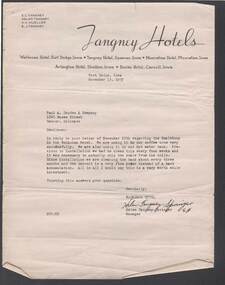
Four letters from Helen Tangney-Springer, Manager of the Wahkonsa Hotel, Fort Dodge, Iowa to Paul A. Douden & Company, dated November 13, 1937. Mentioned in the letter is the use of Scale Buoys in the coffee urns and the hot water tank and the difference in the cleaning of them.Letterhead - Tangney Hotelssciences, instruments - general, scalebuoy, bill ashman collection - correspondence, e c tangney, helen tangney, h h mueller, e j tangney, tangney hotels, wahkonsa hotel, muscatine hotel, arlington hotel, burke hotel, paul a douden & company, helen tangney-springer -
 Bendigo Historical Society Inc.
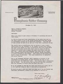
Document - BILL ASHMAN COLLECTION: PENNSYLVANIA RUBBER COMPANY
Five copies of a letter to Paul A. Douden & Company from W. E. Humphrey, Chief Engineer, dated November 12, 1937. Paper has printed letterhead with a photo of the rubber company at the top. Writer mentions that they are pleased with the work of the Scale Buoys and that there is no scale in the pipes. Previously they had to replace piping regularly.sciences, instruments - general, scalebuoy, bill ashman collection - pennsylvania rubber company, paul a douden & company, w e humphrey -
Port Melbourne Historical & Preservation Society
Map - Melbourne and suburbs, MMBW, 8 Dec 1909
MMBW map of Melbourne and suburbs - Record plan up to July 1st 1913 (scale 3/4" = 1 mile)engineering - board of works, calder e oliver, russwaul(?) -
 Coal Creek Community Park & Museum
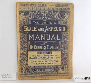
Music Book, The Complete Scale and Arpeggio Manual
Music book, "The Complete Scale and Arpeggio Manual by Dr. Charles E. Allum" Front cover has a blue and white floral design with illustrations of the four seasons in the corners. -
 Bendigo Historical Society Inc.
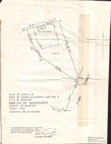
Document - CROWN ALLOTMENT 406A (PLAN) JOSS HOUSE
Plan of Survey of part of Crown Allotment 406A Sec E. City of Bendigo. Parish of Sandhurst. County of Bendigo. Scale 1:500. (Copy of Original). As at 21 February 1979. This survey shows the location of the Joss House and the portion of land where it is located.plan, bendigo, joss house, crown allotment 406a (plan), joss house -
 Royal Australian and New Zealand College of Obstetricians & Gynaecologists (RANZCOG)
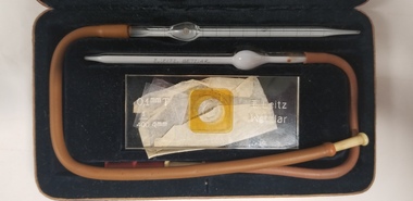
Tool - Breuer haemacytometer in case, Ernst Leitz
A haemacytometer is an instrument used to count blood cells. It is commonly applied to a combination of counting chambers with cover glasses and has pipettes for red and white blood cells. This haemacytometer was manufactured by Ernst Leitz's factory in Metzlar, Germany. This company grew to be come what is now Leica. Haemacytometer in brown leatherette case. Consists of two glass pipettes with attached red rubber tubing, a glass microscope slide, and three small plastic square slide accessories. The base of the case is cut out and lined with felt to accommodate the parts of the object. Top of the case is inlaid with gold coloured text which reads 'Haemacytometer/Breuer/E.Leitz/Wetzlar'. Glass slide is engraved with the text 'E.Leitz/Wetzlar' and scale measurements. Glass pipettes are printed with the text 'E. LEITZ, WETZLAR'.pathology -
 Bendigo Historical Society Inc.
Document - GOLD RUSHES AROUND BENDIGO
Typed and hand written notes on 'Gold Rushes around Bendigo', Eaglehawk Police Station, Bells In and Around Bendigo, Bendigo Historical Society Newsletter, Mr Henry Jones - Gold Buyer, and Sir John Quick. Gold Rushes Around Bendigo tells of some gold finds around Bendigo. Eaglehawk Police Station tells of the Building of the Log Lockups at Eaglehawk and White Hills and where the idea came from. Also the cost of building and source of logs. Bells In and Around Bendigo tell of a tram employee ringing a bell and shouting to all that the tram terminus at the Railway Station was discontinued. When this was sufficiently known the bell went to the Bridge Street Methodist Church. The BHS Newsletter mentions business men's names and connection with their trade. Mr Henry jones - Gold Buyer mentions where his office was and that you could buy gold and money could be exchanged as well. Sir John Quick page tells of the early life of Sir John Quick and his self-education, of the A. N. A. opening in Victoria.document, names of bendigo pioneers, bendigo goldfields, gold rushes around bendigo, caltex oil co, matt egan, thos fleck, knight's brick kiln, water commission, work shops, l king, r king, j mumberry, a kelly, 'auld dart', robert fallon, mrs jane stinton, joch, vol 1 gold nuggets literary society files (manuscript written 1852-1882.), john o'c hattam, eaglehawk police station, mr w perry, log lock-ups, john fry, charles fry, bendigo advertiser 30/3/1949, alex h stone, bendigo advertiser 20/41949, milburn's coffee palace, shell service station, bridge street methodist church, mr don hargreaves, bendigo historical society newsletter, mr buzza, mr ankle, mr foote, mr scales, mr bull, mr mutton, mr body, mr satori, mr tankard, mr punch, mr snowball, mr sweet, mr goody, mr pallett, mr frame, mr henry jones, bendigo advertiser centenary of bendigo supplement 1951, sir john quick, a w llewelyn, australian natives association, friendly society, virginia battery, commonwealth parliament, federation league, mr alfred deakin, mr d'esterre taylor, mr peacock, mr barret, mr george reid, corowa conference 1893, poet gay, bendigo cemetery, centenary history ana 1871-1971, john e menadue -
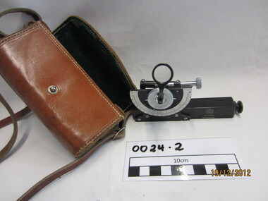 Wannon Water
Clinometre / Abney Level, E. R. Watts & Son, Clinometre
Abney Level / Clinometer is an accurate surveying tool used to measure degrees, percent of grade and topographic elevation. Used for surveying pipe lines.Instrument which consists of a fixed sighting tube, a movable spirit level connected to a pointing arm which turns and pivots. Adjustment knob/screw on top turns to rotate the compass indicator and bubble level. Arched scale graduated 0 to 90 degrees in both directions. Clinometer is housed in a brown leather case with a long leather strap for carrying around the neck.Watts London / No 70131 / Made in England -
Moorabbin Air Museum
Document (item) - Roland Jahne Collection - See Description for details
-
Clunes Museum
Plan - PLANS, Harry E Sando, Borough of Clunes Contract 96.6 of 1893/4, c1894
Harry E Sando C.E. (Borough Enginee) as at 10th March 1894, this plan also signed by the contactor and witness, both signatures are illegibleColoured drawings on tracing/architects papers, pinned with dress makers pins to stiff paper. Scale 2 feet to 1 inchHeadings on plans; "Ground Plan No.1, Ground Plan No.2, Sections of weirscreswick creek, flood mitigation, weir system -
Clunes Museum
Plan - PLAN OF PROPOSED ADDITIONS TO THE CLUNES BUTTER FACTORY
HAND DRAWN PLANS IN BLACK AND RED INK ON GLASS PAPER WHICH IS PINNED WITH DRESSMAKER'S PINS TO BROWN PAPER BACKING SCALE: 1 INCH TO 1 FOOT VARIOUS NOTATIONS HANDWRITTEN INCLUDES "CREATED BY HARRY E SANDO C.E. SIGNED BY ABEL GOLDSWORTHY, CONTRACTOR AND HARRY E SANDO IN BLACK INK 1 DEC 1894clunes butter factory, commercial industry in clunes -
Whitehorse Historical Society Inc.
Map, Melbourne and suburbs, 1923
Section of map 'Melbourne and Suburbs' compiled at the Department of Lands and Survey, Melbourne by E. S. Hilcke, March 1923, reprinted 1940.Section of map 'Melbourne and Suburbs' compiled at the Department of Lands and Survey, Melbourne by E. S. Hilcke, March 1923, reprinted 1940. Scale 40 chains: 1 inch. - Shire of Blackburn and MitchamSection of map 'Melbourne and Suburbs' compiled at the Department of Lands and Survey, Melbourne by E. S. Hilcke, March 1923, reprinted 1940.department of lands and surve, melbourne and suburbs -
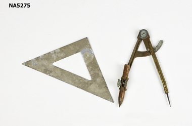 Whitehorse Historical Society Inc.
Instrument - Compass & Set Square, C 1950's
Example of school equipment, c 1950'sExample of equipment used in the teaching of geometry.Example of school geometry equipment.C E H engraved on reverse of set square. Mathematic scales on face of set square.school equipment, geometry -
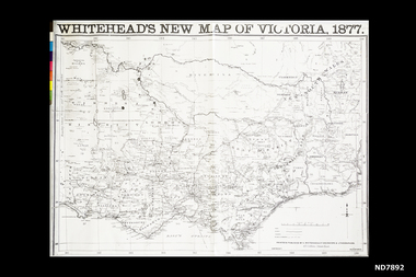 Whitehorse Historical Society Inc.
Map, Whitehead's New map of Victoria, 1877
A map of Victoria produced in 1877non-fictionA map of Victoria produced in 1877map, victoria -
 Rutherglen Historical Society
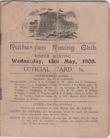
Pamphlet - Offical Race Meeting Card, Thomas Drenen, Rutherglen Racing Club. Winter Meeting: Wednesday, 13th May, 1908, May 1908 (Exact)
Office bearers of the Rutherglen Racing Club: President--Mr W R Commins; Vice-presidents--Messrs S P Gollings, H W Allen and J Geoghegan; Treasurer--Mr J Geoghegan; Judge--Dr Harris J.P.; Handicapper--Mr M Mitchell; Stewards--Messrs W R Commins, M Martin, S P Gollings, J Geoghegan, A Prentice J.P.;H W Allen, H McKay, J Logan, D Frew, J Prentice and H E D Kelly; Clerk of Scales--Mr W J Parlett; Clerk of Course--Mr A Gill; Starter--Mr J Hiskins; Secretary--T Drenen Part of a collection of business documents found under the floor of a building in Main Street when it was being renovated. At that time the owner was Don Chambers, and the premises was occupied as the Chambers Riteway Supermarket. The location (134 Main Street) is currently (2022) occupied by Miegel’s Pharmacy Rutherglen. Horse racing meeting information printed on card.Pencil marks beside some runnersgollings, allen, geoghegan, harris, mitchell, martin, prentice, mckay, logan, frew, kelly, parlett, gill, hiskins, drenen, horse racing, racing, rutherglen racing club, 134 main street, chambers riteway supermarket -
 Ballarat Heritage Services
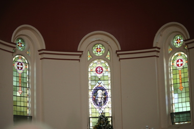
Photograph - Digital photographs, L.J. Gervasoni, St Brigid's Crossley - stained glass window, 2016
"LARGE GATHERINGNG AT - CROSSLEY DEDICATION AND OPENING SERVICES. SERMON BY DR. MANNIX. Yesterday was an important and historic day for the Roman Catholic community of Crossley and Koroit, in as much as it will be always associated in the memories of all con cerned with the opening of the new St. Brigid's Church, Crossley. This building is far above the average standard of sacred edifices in country towns, and is certainly superior to any ercted in this district outside the churches in the two larger centres - Warrnambool and Koroit. The style of architecture chosen is a free treatment of the Romanesque, which is something quite original in the Western District. This noble style, from which, with its near re lative the Byzantine, spring the great Gothic school of architecture, is characterised by a special charm of its own, one of its chief features being graceful and sweeping circular curves in roof, window heads and in the ar rangenent of the ground plan. The building is of brick finished off with true Romanesqiue pillared pinnacles in concrete and plaster, the brick and concrete producing a pleasing contrast. The main characteristic of the front is a large rose window filled with Romlanesque circular tracery, and below a bold porch and entrance. The two sides are pierced with long circular-headed windows between graceful buttresses and the wall line is pleasingly broken by the projecting bays of the confessionals and also by the vestries. The main building is 80 feet by 30 feet' and the Sanctuary is spacious and semi-circular in shape, and lighted by three windows. The interior of the church is most artistic. The ceiling is semi-circular and of fibrous plaster in ornate designs. All the windows are lead lighted, throwing a rich and mellow harmony of' color throughout the interior and the white wails, mouldings, architraves and other fibrous plaster decorations: are further relieved by the rich coloring: in the stations of.the Cross arrranged around the nave. The central window of the Sanctuary contains a splendidly executed stained glass representation of St. Brigid. At.the western end is a room gallery. The altar is a choice piece of Gothic woodwork, in light, soft coloring, and there are two altars on either side of the Sanctuary in oak, and above whlch are very fine colored figures of Christ; and the Madonna. On either side of the altar are life-size figures of angels holding high brass candalabra. The whole of the furnishings of the church are on a sumptuous scale, and the edifice reflects credit on all concerned. The church can seat nearly 500 people. The architect was Mr. A. A. Fritsch. of Melbourne, and the contractors Messrs F. and E. Deagne, of North Fitzroy. The contract price for the building was £5,500. THE OPENING SERVICE. After the cereimony of solemnly blesssing the church was performed by His Lordship the Bishop of the Diocese, Dr. Higgins, assisted by His Grace the Coadjutor Archbishop of Melbourne. Dr. Mannix, the great gatheiring from all parts of the district entered the church, which was soon completely filled. The members of the H.A.C.B.S. attended wearing their green and gold regalia, and acted as a 'guard of honor' to the Co-adjlutor Arclhbishop and Bishop. Mass was celebrated by the Rev. Father Phelan, of Koroit, and a feature of the solemn service was the singing of a choir which consisted of picked voices from St. Carthage's choir, with friends from Warrnam bool and assisted by some of the mem bers of the Koroit choir, with Miss Logan as organist and Mr. Arthur H. Renwick as conductor. They rendered the music in splendid style throghonut. The "Kyrie," "Gloria." "Agnus Dei' and Dona Nobis" were from Farmer's Mass in B flat, and the "Credo" and "Sanctus" from Webbe's Mass in G. The soloists in the Mass were Mrs. Ryan, the Misses McEntee. Miss Katie O'Brien. and Messrs. J. M. Crowley, W. J. Callaghan; B. McEntee and W. Mahony. The chorus sang with great precision, special attention being paid to at tack. At the offertory Mrs. Dan Ryan gave a beautiful rendering of Gounod's "Ava Maria." After the Elevation that fine duet "Tantum Ergo." by Rossi, was sung by Messrs. Crowley and Renwick in an artistic manner, their fine voices blending splendidly. During the collection, Mr. Renwick sang with much feeling that devotional solo, "Lead Thou Me On,", after which Mr Crowley gave .an ex cellent rendering of Weissi's "0 Salu taris Hostia;" and the choir sang several hymns." It might here be mentioned that at the request of Fa ther Kerin, the same choir will repeat the music.at the Koroit Church on Sunday next, on the occasion of the ceremnly of laying the foundation stone of the cormpletion of the church. Dr. Mannix preachled the sermon for the occasion, taking his text from St. Luke first 11 verses. He re viewed the Gospel story of Christ preaching to the multitude from a boat on Lake Gennesaret and the miraculous draught of fish. The obedi ence of the poor fishermen in casting their nets at Christ's bidding was richly rewarded, and the miraculous occurrence was a striking example of what was to happen when Christ established His Church and built it up on those twelve apostles. When they came to think of it, nothing so re markable and marvellous had happened before or since in the history of mankind. The world at that time was for the most part a Pagan world steeped in iniquity and sin. The chosen people of God had God's re velation, but they worshipped with their lips and not with their hearts. When Christ was to establish His Church upon earth and leave an or gantisation that would continue His work, did He select learned men, powerful men, rich men, or a time that would seem propituous? No. He selected twelve poor, igorant simple fishermen, without money, power, learning or anything calculated to enable them to do anything striking in the world's history. The success of the first morning after pentecost was not confined to those first days when the plentitude of the Holy Ghost sat upon the .Apostles, but it continued age after age until the whole world was brought within the sphere of ac tion of the Church. Greece, Rome Europe Asia and America, and now Australia had been brought into the net. This must be a consolation to them all as well as it was to him (the preacher), when they remembered that they came from a land which of all others had been faithful to the Gospel of Jesus Christ. It was a consolation to them that in that great work that had been accomplished in bringing men into the meshes of the Church, and bringing them to God the nation to which they belontged had taken so great a part. Their religion flourished in England, Scotland, America and Australia. Surely it was due to the sons of St. Patrick, the sons and daughters of Ireland to find consolation in these great facts might It might seem hard that so many had to leave their native-land for England, Scotland, America and Australia. But if hard it was the means of keeping the Catholic faith living in England and Scotland. If to-day the Irish Catholics and Catholics of Irish de scent were taken out of the English and Scotch population there would be little left of the true Church of God. It seemed hard to emigrate to distant lands, but the result had been the new magnificent church in the United States, the flourishing churches in Canada and South Africa. Those Irish emigrants were a cornparatively small band. Perhaps they had not the learning of other nations. Certainly they had not the wealth and it did not fall to their lot to have the power of the sword, but God was with them, and the faith they took from Ireland flourished in those distant lands. In this fair land of Australia they had a glorious herit age handed down from the pioneer Irish Catholics, who came to this fair Austral land. There was a time when those who were opposed to God and God's Church,thought that Australia should be a wholly Protestant land. They had lived to see whether God or His enemies were the stronger. They had lived to see that those who in distant days would have stamped out the Catholic religion in Australia, had not prevailed. Their names had been forgotten because of their persecution of the Catholic Church, and they had lived - to see the glorious success that now, in every part of the Common wealth, rested upon the Catholic Church in Australia. Might God bless that Church and those Irish people, and the people of Irish descent, who had built it up. In that locality, and there was no place in.the Common wealth where the Catholic Church was held in higher esteem, the people would always be faithful to God and His Church. That beautiful building, and all it signified in loyalty and faithfulness, was a credit and a consolation to the Bishop and people of the diocese, to the architect who had done his work so artistically and skil fully. to the priests and the zealous administration of the parish. There was surely hope and inspiration in that day's celebration, that as time went on the Catholic faith would sink deeper and deeper into ther coming generation, and that the Catholic progress of the past 50 years would be small in comparison to the great progress of the future. He congratulated the Bishop priests and people who had raised that temple. He congratulated the people of Crossley; upon their generosity and self-sacrifice, and he prayed that God's blessing and the blessing of St. Brigid would rest upon them; their children and children's children. And when those who had received the sacraments and had been instructed in that Church were called before the Judgment Seat he pray ed that not one would be missing, and St. Peter aind St. Brigid would be able to count them all into the en joyment .of Eternal bliss. THE CELEBRATION The Rev. Father Kerin, Adninistra tor of the Parish, after the collection, read a lengthy list of the principal donations, headed by the Bishop, Dr. Higgins, with £250. All the furnish ings of the Church were also donations, and the Coadjutor-Archbishop added £5 to the list. The Rev. Father Kerin stated that the total to hand was £1245/10/7, which was an other proof of the generosity of the Crossley and district people. The amount previously received in donations was £1077/3. They started buildiing with a credit balance of £262 10/5 and ther now had a debit balance of £2,728/18/5. The total cost of the Church was £6,250, so that they would see the greater part of the indebtedness had already been wiped out. The Bishop (Dr. Higgins) delivered a brief address, in the course of which he congratulated the priests and people upon the completion of their magnificent Church. He congratulated the people on their magnificent generosity. He expressed his of deep indebtedness to the Coadjutor Archbishop of Melbourne for the services he had rendered to them. He had attended at considerable sacrifice to himself, and they were extremely grateful for the presence of so distinguished a champion who had shown such zeal and interest in their Church in this new land. He (the Bishop) trusted that his splendid talents would long be devoted to the defence of the Church." (Warrnambul Standard, 02 July 1914)Digital images of the stained glass windows at St Brigid's, Crossley.victoria, crossley, st brigid's crossley, st brigid's, catholic church, catholic, church, religion, stained glass, window -
 Ballarat Heritage Services
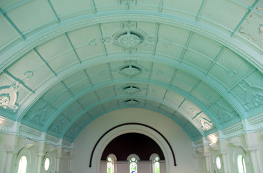
Digital photographs, St Brigid's Crossley - Christmas Carols, 2016, Christmas 2016
"LARGE GATHERINGNG AT - CROSSLEY DEDICATION AND OPENING SERVICES. SERMON BY DR. MANNIX. Yesterday was an important and historic day for the Roman Catholic community of Crossley and Koroit, in as much as it will be always associated in the memories of all con cerned with the opening of the new St. Brigid's Church, Crossley. This building is far above the average standard of sacred edifices in country towns, and is certainly superior to any ercted in this district outside the churches in the two larger centres - Warrnambool and Koroit. The style of architecture chosen is a free treatment of the Romanesque, which is something quite original in the Western District. This noble style, from which, with its near re lative the Byzantine, spring the great Gothic school of architecture, is characterised by a special charm of its own, one of its chief features being graceful and sweeping circular curves in roof, window heads and in the ar rangenent of the ground plan. The building is of brick finished off with true Romanesqiue pillared pinnacles in concrete and plaster, the brick and concrete producing a pleasing contrast. The main characteristic of the front is a large rose window filled with Romlanesque circular tracery, and below a bold porch and entrance. The two sides are pierced with long circular-headed windows between graceful buttresses and the wall line is pleasingly broken by the projecting bays of the confessionals and also by the vestries. The main building is 80 feet by 30 feet' and the Sanctuary is spacious and semi-circular in shape, and lighted by three windows. The interior of the church is most artistic. The ceiling is semi-circular and of fibrous plaster in ornate designs. All the windows are lead lighted, throwing a rich and mellow harmony of' color throughout the interior and the white wails, mouldings, architraves and other fibrous plaster decorations: are further relieved by the rich coloring: in the stations of.the Cross arrranged around the nave. The central window of the Sanctuary contains a splendidly executed stained glass representation of St. Brigid. At.the western end is a room gallery. The altar is a choice piece of Gothic woodwork, in light, soft coloring, and there are two altars on either side of the Sanctuary in oak, and above whlch are very fine colored figures of Christ; and the Madonna. On either side of the altar are life-size figures of angels holding high brass candalabra. The whole of the furnishings of the church are on a sumptuous scale, and the edifice reflects credit on all concerned. The church can seat nearly 500 people. The architect was Mr. A. A. Fritsch. of Melbourne, and the contractors Messrs F. and E. Deagne, of North Fitzroy. The contract price for the building was £5,500. THE OPENING SERVICE. After the cereimony of solemnly blesssing the church was performed by His Lordship the Bishop of the Diocese, Dr. Higgins, assisted by His Grace the Coadjutor Archbishop of Melbourne. Dr. Mannix, the great gatheiring from all parts of the district entered the church, which was soon completely filled. The members of the H.A.C.B.S. attended wearing their green and gold regalia, and acted as a 'guard of honor' to the Co-adjlutor Arclhbishop and Bishop. Mass was celebrated by the Rev. Father Phelan, of Koroit, and a feature of the solemn service was the singing of a choir which consisted of picked voices from St. Carthage's choir, with friends from Warrnam bool and assisted by some of the mem bers of the Koroit choir, with Miss Logan as organist and Mr. Arthur H. Renwick as conductor. They rendered the music in splendid style throghonut. The "Kyrie," "Gloria." "Agnus Dei' and Dona Nobis" were from Farmer's Mass in B flat, and the "Credo" and "Sanctus" from Webbe's Mass in G. The soloists in the Mass were Mrs. Ryan, the Misses McEntee. Miss Katie O'Brien. and Messrs. J. M. Crowley, W. J. Callaghan; B. McEntee and W. Mahony. The chorus sang with great precision, special attention being paid to at tack. At the offertory Mrs. Dan Ryan gave a beautiful rendering of Gounod's "Ava Maria." After the Elevation that fine duet "Tantum Ergo." by Rossi, was sung by Messrs. Crowley and Renwick in an artistic manner, their fine voices blending splendidly. During the collection, Mr. Renwick sang with much feeling that devotional solo, "Lead Thou Me On,", after which Mr Crowley gave .an ex cellent rendering of Weissi's "0 Salu taris Hostia;" and the choir sang several hymns." It might here be mentioned that at the request of Fa ther Kerin, the same choir will repeat the music.at the Koroit Church on Sunday next, on the occasion of the ceremnly of laying the foundation stone of the cormpletion of the church. Dr. Mannix preachled the sermon for the occasion, taking his text from St. Luke first 11 verses. He re viewed the Gospel story of Christ preaching to the multitude from a boat on Lake Gennesaret and the miraculous draught of fish. The obedi ence of the poor fishermen in casting their nets at Christ's bidding was richly rewarded, and the miraculous occurrence was a striking example of what was to happen when Christ established His Church and built it up on those twelve apostles. When they came to think of it, nothing so re markable and marvellous had happened before or since in the history of mankind. The world at that time was for the most part a Pagan world steeped in iniquity and sin. The chosen people of God had God's re velation, but they worshipped with their lips and not with their hearts. When Christ was to establish His Church upon earth and leave an or gantisation that would continue His work, did He select learned men, powerful men, rich men, or a time that would seem propituous? No. He selected twelve poor, igorant simple fishermen, without money, power, learning or anything calculated to enable them to do anything striking in the world's history. The success of the first morning after pentecost was not confined to those first days when the plentitude of the Holy Ghost sat upon the .Apostles, but it continued age after age until the whole world was brought within the sphere of ac tion of the Church. Greece, Rome Europe Asia and America, and now Australia had been brought into the net. This must be a consolation to them all as well as it was to him (the preacher), when they remembered that they came from a land which of all others had been faithful to the Gospel of Jesus Christ. It was a consolation to them that in that great work that had been accomplished in bringing men into the meshes of the Church, and bringing them to God the nation to which they belontged had taken so great a part. Their religion flourished in England, Scotland, America and Australia. Surely it was due to the sons of St. Patrick, the sons and daughters of Ireland to find consolation in these great facts might It might seem hard that so many had to leave their native-land for England, Scotland, America and Australia. But if hard it was the means of keeping the Catholic faith living in England and Scotland. If to-day the Irish Catholics and Catholics of Irish de scent were taken out of the English and Scotch population there would be little left of the true Church of God. It seemed hard to emigrate to distant lands, but the result had been the new magnificent church in the United States, the flourishing churches in Canada and South Africa. Those Irish emigrants were a cornparatively small band. Perhaps they had not the learning of other nations. Certainly they had not the wealth and it did not fall to their lot to have the power of the sword, but God was with them, and the faith they took from Ireland flourished in those distant lands. In this fair land of Australia they had a glorious herit age handed down from the pioneer Irish Catholics, who came to this fair Austral land. There was a time when those who were opposed to God and God's Church,thought that Australia should be a wholly Protestant land. They had lived to see whether God or His enemies were the stronger. They had lived to see that those who in distant days would have stamped out the Catholic religion in Australia, had not prevailed. Their names had been forgotten because of their persecution of the Catholic Church, and they had lived - to see the glorious success that now, in every part of the Common wealth, rested upon the Catholic Church in Australia. Might God bless that Church and those Irish people, and the people of Irish descent, who had built it up. In that locality, and there was no place in.the Common wealth where the Catholic Church was held in higher esteem, the people would always be faithful to God and His Church. That beautiful building, and all it signified in loyalty and faithfulness, was a credit and a consolation to the Bishop and people of the diocese, to the architect who had done his work so artistically and skil fully. to the priests and the zealous administration of the parish. There was surely hope and inspiration in that day's celebration, that as time went on the Catholic faith would sink deeper and deeper into ther coming generation, and that the Catholic progress of the past 50 years would be small in comparison to the great progress of the future. He congratulated the Bishop priests and people who had raised that temple. He congratulated the people of Crossley; upon their generosity and self-sacrifice, and he prayed that God's blessing and the blessing of St. Brigid would rest upon them; their children and children's children. And when those who had received the sacraments and had been instructed in that Church were called before the Judgment Seat he pray ed that not one would be missing, and St. Peter aind St. Brigid would be able to count them all into the en joyment .of Eternal bliss. THE CELEBRATION The Rev. Father Kerin, Adninistra tor of the Parish, after the collection, read a lengthy list of the principal donations, headed by the Bishop, Dr. Higgins, with £250. All the furnish ings of the Church were also donations, and the Coadjutor-Archbishop added £5 to the list. The Rev. Father Kerin stated that the total to hand was £1245/10/7, which was an other proof of the generosity of the Crossley and district people. The amount previously received in donations was £1077/3. They started buildiing with a credit balance of £262 10/5 and ther now had a debit balance of £2,728/18/5. The total cost of the Church was £6,250, so that they would see the greater part of the indebtedness had already been wiped out. The Bishop (Dr. Higgins) delivered a brief address, in the course of which he congratulated the priests and people upon the completion of their magnificent Church. He congratulated the people on their magnificent generosity. He expressed his of deep indebtedness to the Coadjutor Archbishop of Melbourne for the services he had rendered to them. He had attended at considerable sacrifice to himself, and they were extremely grateful for the presence of so distinguished a champion who had shown such zeal and interest in their Church in this new land. He (the Bishop) trusted that his splendid talents would long be devoted to the defence of the Church." (Warrnambul Standard, 02 July 1914)Digital images of the interior of St Brigid's, Crossley.st brigid's crossley, st brigid's, catholic church, catholic, church, religion, celebrations, christmas, christmas carols, carols, stained glass, window -
 Ballarat Heritage Services
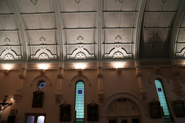
Photograph - Digital photographs, L.J. Gervasoni, Interior of St Brigid's Crossley, C2016
"LARGE GATHERINGNG AT - CROSSLEY DEDICATION AND OPENING SERVICES. SERMON BY DR. MANNIX. Yesterday was an important and historic day for the Roman Catholic community of Crossley and Koroit, in as much as it will be always associated in the memories of all con cerned with the opening of the new St. Brigid's Church, Crossley. This building is far above the average standard of sacred edifices in country towns, and is certainly superior to any ercted in this district outside the churches in the two larger centres - Warrnambool and Koroit. The style of architecture chosen is a free treatment of the Romanesque, which is something quite original in the Western District. This noble style, from which, with its near re lative the Byzantine, spring the great Gothic school of architecture, is characterised by a special charm of its own, one of its chief features being graceful and sweeping circular curves in roof, window heads and in the ar rangenent of the ground plan. The building is of brick finished off with true Romanesqiue pillared pinnacles in concrete and plaster, the brick and concrete producing a pleasing contrast. The main characteristic of the front is a large rose window filled with Romlanesque circular tracery, and below a bold porch and entrance. The two sides are pierced with long circular-headed windows between graceful buttresses and the wall line is pleasingly broken by the projecting bays of the confessionals and also by the vestries. The main building is 80 feet by 30 feet' and the Sanctuary is spacious and semi-circular in shape, and lighted by three windows. The interior of the church is most artistic. The ceiling is semi-circular and of fibrous plaster in ornate designs. All the windows are lead lighted, throwing a rich and mellow harmony of' color throughout the interior and the white wails, mouldings, architraves and other fibrous plaster decorations: are further relieved by the rich coloring: in the stations of.the Cross arrranged around the nave. The central window of the Sanctuary contains a splendidly executed stained glass representation of St. Brigid. At.the western end is a room gallery. The altar is a choice piece of Gothic woodwork, in light, soft coloring, and there are two altars on either side of the Sanctuary in oak, and above whlch are very fine colored figures of Christ; and the Madonna. On either side of the altar are life-size figures of angels holding high brass candalabra. The whole of the furnishings of the church are on a sumptuous scale, and the edifice reflects credit on all concerned. The church can seat nearly 500 people. The architect was Mr. A. A. Fritsch. of Melbourne, and the contractors Messrs F. and E. Deagne, of North Fitzroy. The contract price for the building was £5,500. THE OPENING SERVICE. After the cereimony of solemnly blesssing the church was performed by His Lordship the Bishop of the Diocese, Dr. Higgins, assisted by His Grace the Coadjutor Archbishop of Melbourne. Dr. Mannix, the great gatheiring from all parts of the district entered the church, which was soon completely filled. The members of the H.A.C.B.S. attended wearing their green and gold regalia, and acted as a 'guard of honor' to the Co-adjlutor Arclhbishop and Bishop. Mass was celebrated by the Rev. Father Phelan, of Koroit, and a feature of the solemn service was the singing of a choir which consisted of picked voices from St. Carthage's choir, with friends from Warrnam bool and assisted by some of the mem bers of the Koroit choir, with Miss Logan as organist and Mr. Arthur H. Renwick as conductor. They rendered the music in splendid style throghonut. The "Kyrie," "Gloria." "Agnus Dei' and Dona Nobis" were from Farmer's Mass in B flat, and the "Credo" and "Sanctus" from Webbe's Mass in G. The soloists in the Mass were Mrs. Ryan, the Misses McEntee. Miss Katie O'Brien. and Messrs. J. M. Crowley, W. J. Callaghan; B. McEntee and W. Mahony. The chorus sang with great precision, special attention being paid to at tack. At the offertory Mrs. Dan Ryan gave a beautiful rendering of Gounod's "Ava Maria." After the Elevation that fine duet "Tantum Ergo." by Rossi, was sung by Messrs. Crowley and Renwick in an artistic manner, their fine voices blending splendidly. During the collection, Mr. Renwick sang with much feeling that devotional solo, "Lead Thou Me On,", after which Mr Crowley gave .an ex cellent rendering of Weissi's "0 Salu taris Hostia;" and the choir sang several hymns." It might here be mentioned that at the request of Fa ther Kerin, the same choir will repeat the music.at the Koroit Church on Sunday next, on the occasion of the ceremnly of laying the foundation stone of the cormpletion of the church. Dr. Mannix preachled the sermon for the occasion, taking his text from St. Luke first 11 verses. He re viewed the Gospel story of Christ preaching to the multitude from a boat on Lake Gennesaret and the miraculous draught of fish. The obedi ence of the poor fishermen in casting their nets at Christ's bidding was richly rewarded, and the miraculous occurrence was a striking example of what was to happen when Christ established His Church and built it up on those twelve apostles. When they came to think of it, nothing so re markable and marvellous had happened before or since in the history of mankind. The world at that time was for the most part a Pagan world steeped in iniquity and sin. The chosen people of God had God's re velation, but they worshipped with their lips and not with their hearts. When Christ was to establish His Church upon earth and leave an or gantisation that would continue His work, did He select learned men, powerful men, rich men, or a time that would seem propituous? No. He selected twelve poor, igorant simple fishermen, without money, power, learning or anything calculated to enable them to do anything striking in the world's history. The success of the first morning after pentecost was not confined to those first days when the plentitude of the Holy Ghost sat upon the .Apostles, but it continued age after age until the whole world was brought within the sphere of ac tion of the Church. Greece, Rome Europe Asia and America, and now Australia had been brought into the net. This must be a consolation to them all as well as it was to him (the preacher), when they remembered that they came from a land which of all others had been faithful to the Gospel of Jesus Christ. It was a consolation to them that in that great work that had been accomplished in bringing men into the meshes of the Church, and bringing them to God the nation to which they belontged had taken so great a part. Their religion flourished in England, Scotland, America and Australia. Surely it was due to the sons of St. Patrick, the sons and daughters of Ireland to find consolation in these great facts might It might seem hard that so many had to leave their native-land for England, Scotland, America and Australia. But if hard it was the means of keeping the Catholic faith living in England and Scotland. If to-day the Irish Catholics and Catholics of Irish de scent were taken out of the English and Scotch population there would be little left of the true Church of God. It seemed hard to emigrate to distant lands, but the result had been the new magnificent church in the United States, the flourishing churches in Canada and South Africa. Those Irish emigrants were a cornparatively small band. Perhaps they had not the learning of other nations. Certainly they had not the wealth and it did not fall to their lot to have the power of the sword, but God was with them, and the faith they took from Ireland flourished in those distant lands. In this fair land of Australia they had a glorious herit age handed down from the pioneer Irish Catholics, who came to this fair Austral land. There was a time when those who were opposed to God and God's Church,thought that Australia should be a wholly Protestant land. They had lived to see whether God or His enemies were the stronger. They had lived to see that those who in distant days would have stamped out the Catholic religion in Australia, had not prevailed. Their names had been forgotten because of their persecution of the Catholic Church, and they had lived - to see the glorious success that now, in every part of the Common wealth, rested upon the Catholic Church in Australia. Might God bless that Church and those Irish people, and the people of Irish descent, who had built it up. In that locality, and there was no place in.the Common wealth where the Catholic Church was held in higher esteem, the people would always be faithful to God and His Church. That beautiful building, and all it signified in loyalty and faithfulness, was a credit and a consolation to the Bishop and people of the diocese, to the architect who had done his work so artistically and skil fully. to the priests and the zealous administration of the parish. There was surely hope and inspiration in that day's celebration, that as time went on the Catholic faith would sink deeper and deeper into ther coming generation, and that the Catholic progress of the past 50 years would be small in comparison to the great progress of the future. He congratulated the Bishop priests and people who had raised that temple. He congratulated the people of Crossley; upon their generosity and self-sacrifice, and he prayed that God's blessing and the blessing of St. Brigid would rest upon them; their children and children's children. And when those who had received the sacraments and had been instructed in that Church were called before the Judgment Seat he pray ed that not one would be missing, and St. Peter aind St. Brigid would be able to count them all into the en joyment .of Eternal bliss. THE CELEBRATION The Rev. Father Kerin, Adninistra tor of the Parish, after the collection, read a lengthy list of the principal donations, headed by the Bishop, Dr. Higgins, with £250. All the furnish ings of the Church were also donations, and the Coadjutor-Archbishop added £5 to the list. The Rev. Father Kerin stated that the total to hand was £1245/10/7, which was an other proof of the generosity of the Crossley and district people. The amount previously received in donations was £1077/3. They started buildiing with a credit balance of £262 10/5 and ther now had a debit balance of £2,728/18/5. The total cost of the Church was £6,250, so that they would see the greater part of the indebtedness had already been wiped out. The Bishop (Dr. Higgins) delivered a brief address, in the course of which he congratulated the priests and people upon the completion of their magnificent Church. He congratulated the people on their magnificent generosity. He expressed his of deep indebtedness to the Coadjutor Archbishop of Melbourne for the services he had rendered to them. He had attended at considerable sacrifice to himself, and they were extremely grateful for the presence of so distinguished a champion who had shown such zeal and interest in their Church in this new land. He (the Bishop) trusted that his splendid talents would long be devoted to the defence of the Church." (Warrnambul Standard, 02 July 1914)Digital images of the in..terior of St Brigid's Crossleyst brigid's crossley, st brigid's, catholic church, catholic, church, community, ceiling, stations of the cross, confessional, statues, windows -
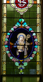 Ballarat Heritage Services
Photograph, Lisa Gervasoni, St Brigid Stained Glass Window, Crossley, 18/08/2013
"LARGE GATHERINGNG AT - CROSSLEY DEDICATION AND OPENING SERVICES. SERMON BY DR. MANNIX. Yesterday was an important and historic day for the Roman Catholic community of Crossley and Koroit, in as much as it will be always associated in the memories of all con cerned with the opening of the new St. Brigid's Church, Crossley. This building is far above the average standard of sacred edifices in country towns, and is certainly superior to any ercted in this district outside the churches in the two larger centres - Warrnambool and Koroit. The style of architecture chosen is a free treatment of the Romanesque, which is something quite original in the Western District. This noble style, from which, with its near re lative the Byzantine, spring the great Gothic school of architecture, is characterised by a special charm of its own, one of its chief features being graceful and sweeping circular curves in roof, window heads and in the ar rangenent of the ground plan. The building is of brick finished off with true Romanesqiue pillared pinnacles in concrete and plaster, the brick and concrete producing a pleasing contrast. The main characteristic of the front is a large rose window filled with Romlanesque circular tracery, and below a bold porch and entrance. The two sides are pierced with long circular-headed windows between graceful buttresses and the wall line is pleasingly broken by the projecting bays of the confessionals and also by the vestries. The main building is 80 feet by 30 feet' and the Sanctuary is spacious and semi-circular in shape, and lighted by three windows. The interior of the church is most artistic. The ceiling is semi-circular and of fibrous plaster in ornate designs. All the windows are lead lighted, throwing a rich and mellow harmony of' color throughout the interior and the white wails, mouldings, architraves and other fibrous plaster decorations: are further relieved by the rich coloring: in the stations of.the Cross arrranged around the nave. The central window of the Sanctuary contains a splendidly executed stained glass representation of St. Brigid. At.the western end is a room gallery. The altar is a choice piece of Gothic woodwork, in light, soft coloring, and there are two altars on either side of the Sanctuary in oak, and above whlch are very fine colored figures of Christ; and the Madonna. On either side of the altar are life-size figures of angels holding high brass candalabra. The whole of the furnishings of the church are on a sumptuous scale, and the edifice reflects credit on all concerned. The church can seat nearly 500 people. The architect was Mr. A. A. Fritsch. of Melbourne, and the contractors Messrs F. and E. Deagne, of North Fitzroy. The contract price for the building was £5,500. THE OPENING SERVICE. After the cereimony of solemnly blesssing the church was performed by His Lordship the Bishop of the Diocese, Dr. Higgins, assisted by His Grace the Coadjutor Archbishop of Melbourne. Dr. Mannix, the great gatheiring from all parts of the district entered the church, which was soon completely filled. The members of the H.A.C.B.S. attended wearing their green and gold regalia, and acted as a 'guard of honor' to the Co-adjlutor Arclhbishop and Bishop. Mass was celebrated by the Rev. Father Phelan, of Koroit, and a feature of the solemn service was the singing of a choir which consisted of picked voices from St. Carthage's choir, with friends from Warrnam bool and assisted by some of the mem bers of the Koroit choir, with Miss Logan as organist and Mr. Arthur H. Renwick as conductor. They rendered the music in splendid style throghonut. The "Kyrie," "Gloria." "Agnus Dei' and Dona Nobis" were from Farmer's Mass in B flat, and the "Credo" and "Sanctus" from Webbe's Mass in G. The soloists in the Mass were Mrs. Ryan, the Misses McEntee. Miss Katie O'Brien. and Messrs. J. M. Crowley, W. J. Callaghan; B. McEntee and W. Mahony. The chorus sang with great precision, special attention being paid to at tack. At the offertory Mrs. Dan Ryan gave a beautiful rendering of Gounod's "Ava Maria." After the Elevation that fine duet "Tantum Ergo." by Rossi, was sung by Messrs. Crowley and Renwick in an artistic manner, their fine voices blending splendidly. During the collection, Mr. Renwick sang with much feeling that devotional solo, "Lead Thou Me On,", after which Mr Crowley gave .an ex cellent rendering of Weissi's "0 Salu taris Hostia;" and the choir sang several hymns." It might here be mentioned that at the request of Fa ther Kerin, the same choir will repeat the music.at the Koroit Church on Sunday next, on the occasion of the ceremnly of laying the foundation stone of the cormpletion of the church. Dr. Mannix preachled the sermon for the occasion, taking his text from St. Luke first 11 verses. He re viewed the Gospel story of Christ preaching to the multitude from a boat on Lake Gennesaret and the miraculous draught of fish. The obedi ence of the poor fishermen in casting their nets at Christ's bidding was richly rewarded, and the miraculous occurrence was a striking example of what was to happen when Christ established His Church and built it up on those twelve apostles. When they came to think of it, nothing so re markable and marvellous had happened before or since in the history of mankind. The world at that time was for the most part a Pagan world steeped in iniquity and sin. The chosen people of God had God's re velation, but they worshipped with their lips and not with their hearts. When Christ was to establish His Church upon earth and leave an or gantisation that would continue His work, did He select learned men, powerful men, rich men, or a time that would seem propituous? No. He selected twelve poor, igorant simple fishermen, without money, power, learning or anything calculated to enable them to do anything striking in the world's history. The success of the first morning after pentecost was not confined to those first days when the plentitude of the Holy Ghost sat upon the .Apostles, but it continued age after age until the whole world was brought within the sphere of ac tion of the Church. Greece, Rome Europe Asia and America, and now Australia had been brought into the net. This must be a consolation to them all as well as it was to him (the preacher), when they remembered that they came from a land which of all others had been faithful to the Gospel of Jesus Christ. It was a consolation to them that in that great work that had been accomplished in bringing men into the meshes of the Church, and bringing them to God the nation to which they belontged had taken so great a part. Their religion flourished in England, Scotland, America and Australia. Surely it was due to the sons of St. Patrick, the sons and daughters of Ireland to find consolation in these great facts might It might seem hard that so many had to leave their native-land for England, Scotland, America and Australia. But if hard it was the means of keeping the Catholic faith living in England and Scotland. If to-day the Irish Catholics and Catholics of Irish de scent were taken out of the English and Scotch population there would be little left of the true Church of God. It seemed hard to emigrate to distant lands, but the result had been the new magnificent church in the United States, the flourishing churches in Canada and South Africa. Those Irish emigrants were a cornparatively small band. Perhaps they had not the learning of other nations. Certainly they had not the wealth and it did not fall to their lot to have the power of the sword, but God was with them, and the faith they took from Ireland flourished in those distant lands. In this fair land of Australia they had a glorious herit age handed down from the pioneer Irish Catholics, who came to this fair Austral land. There was a time when those who were opposed to God and God's Church,thought that Australia should be a wholly Protestant land. They had lived to see whether God or His enemies were the stronger. They had lived to see that those who in distant days would have stamped out the Catholic religion in Australia, had not prevailed. Their names had been forgotten because of their persecution of the Catholic Church, and they had lived - to see the glorious success that now, in every part of the Common wealth, rested upon the Catholic Church in Australia. Might God bless that Church and those Irish people, and the people of Irish descent, who had built it up. In that locality, and there was no place in.the Common wealth where the Catholic Church was held in higher esteem, the people would always be faithful to God and His Church. That beautiful building, and all it signified in loyalty and faithfulness, was a credit and a consolation to the Bishop and people of the diocese, to the architect who had done his work so artistically and skil fully. to the priests and the zealous administration of the parish. There was surely hope and inspiration in that day's celebration, that as time went on the Catholic faith would sink deeper and deeper into ther coming generation, and that the Catholic progress of the past 50 years would be small in comparison to the great progress of the future. He congratulated the Bishop priests and people who had raised that temple. He congratulated the people of Crossley; upon their generosity and self-sacrifice, and he prayed that God's blessing and the blessing of St. Brigid would rest upon them; their children and children's children. And when those who had received the sacraments and had been instructed in that Church were called before the Judgment Seat he pray ed that not one would be missing, and St. Peter aind St. Brigid would be able to count them all into the en joyment .of Eternal bliss. THE CELEBRATION The Rev. Father Kerin, Adninistra tor of the Parish, after the collection, read a lengthy list of the principal donations, headed by the Bishop, Dr. Higgins, with £250. All the furnish ings of the Church were also donations, and the Coadjutor-Archbishop added £5 to the list. The Rev. Father Kerin stated that the total to hand was £1245/10/7, which was an other proof of the generosity of the Crossley and district people. The amount previously received in donations was £1077/3. They started buildiing with a credit balance of £262 10/5 and ther now had a debit balance of £2,728/18/5. The total cost of the Church was £6,250, so that they would see the greater part of the indebtedness had already been wiped out. The Bishop (Dr. Higgins) delivered a brief address, in the course of which he congratulated the priests and people upon the completion of their magnificent Church. He congratulated the people on their magnificent generosity. He expressed his of deep indebtedness to the Coadjutor Archbishop of Melbourne for the services he had rendered to them. He had attended at considerable sacrifice to himself, and they were extremely grateful for the presence of so distinguished a champion who had shown such zeal and interest in their Church in this new land. He (the Bishop) trusted that his splendid talents would long be devoted to the defence of the Church." (Warrnambul Standard, 02 July 1914)Colour photograph of a portrait of St Brigid in stained glass. The depiction of St Brigid is located at St Brigid's former Catholic Church, Crossley.st brigid, stained glass, st brigid's crossley -
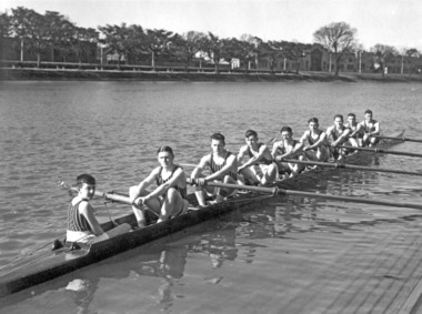 Power House Rowing Club
Black and white photograph, The Sears Studio St Kilda, PHRC Novice VIII, 1936
Digital scan of framed black and white photograph.J Barton Jnr (cox) I Scales (Str) N West (&) J Chadwick (6) J Fuller (5) D Stewart (4) L Orr (3) D Garside (2) E Campbell (Bow) J Barton Snr (Coach) -
 Maldon Vintage Machinery Museum Inc
Drawing Machine, Pre WW2
... ) Scale rule "W & G E 18". .3) Scale rule "W & G E 12". .4... No. ? / Melbourne. Aust." .2) Scale rule "W & G E 18". .3) Scale rule "W & G ..."Ray & Gilbert" articulated arm type manual drawing machine as used in a drawing office. Fitted with "W & G" scale rulers. Rulers are plastic coated timber. Black arms and handle, white rulers. Mounted on a wooden drawing board.. .4) Metal adjusting spanner..1) At mounting pivot point of drawing machine "Ray & Gilbert / Drafting Machine / Serial No. ? / Melbourne. Aust." .2) Scale rule "W & G E 18". .3) Scale rule "W & G E 12". .4) No inscriptions.drafting, engineering -
 Federation University Art Collection
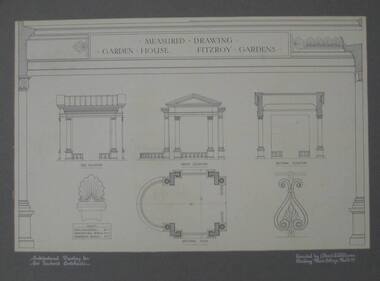
Architectural Drawing, Measured drawing ornament House Fitzroy Gardens by Albert E. Williams, c1920, c1920
Albert E. Williams first studied art under Fred Foster after being awarded a scholarship to the Ballarat East Art School. In 1913 he became one of the first intake of 83 students to study the Merit Certificate at the newly opened Ballarat Junior Technical School. Williams was the second person to receive a certificate from that institution. He then studied under H.H. Smith for the Art Teachers’ Certificate at the Ballarat School of Mines Technical Art School between 1915 and 1920. Williams joined the staff of the Ballarat Junior Technical School in 1921, teaching sign writing, ticket writing and house decoration. He taught in other technical schools between 1923 and 1928, returning to Ballarat in that year to fill a vacancy left by John Rowell . Williams continued his teaching career at both the Ballarat School of Mines Technical Art School and the Junior Technical School until 1942. He taught in various other technical schools from 1943, retiring as Headmaster of the Brighton Technical School in 1964. Albert E. Williams continued producing artwork throughout his career, and was responsible for the education of generations of artists and art teachers. This item is part of the Federation University Art Collection. The Art Collection features over 1000 works and was listed as a 'Ballarat Treasure' in 2007.Pen and ink measured drawing showing side elevation, front elevation, sectional elevation and scales.art, artwork, williams, albert e. williams, ballarat technical art school, architecture, art teachers' certificate -
 University of Melbourne, Burnley Campus Archives
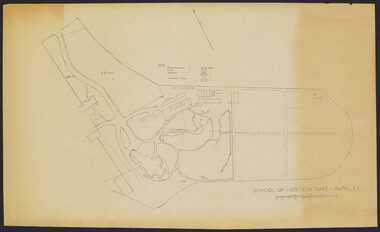
Plan - Sketch, School of Horticulture - Burnley, 1957
... is shown on plan. (E) has further annotation. Scale 1 inch:40 ft.... burnley school of horticulture A,B,C,E paper copies, D, tracing ...A,B,C,E paper copies, D, tracing paper copy of plan. Hand drawn sketch of central area of grounds. Figures given for acreage of ornamentals, crops and grazing although only 1 acreage is shown on plan. (E) has further annotation. Scale 1 inch:40 ft.burnley gardens, ornmental, crops, grazing, burnley school of horticulture -
University of Melbourne, Burnley Campus Archives
Plan, Burnley Theme Gardens, 1988-1989
Plans for Victorian College of Agriculture and Horticulture, Burnley Campus, Second Year Associate Diploma Students. All Scale 1:50. Tracing paper, paper and laminated copies. (1) Scented Garden, designed by G. Fryer, drawn by S. Mullany. October 1988. (2) Native Garden, designed by L. Garn(e)tt, drawn by S. Mullany, October 1988. (3) Contemporary Garden, designed by Sara Esposito, drawn by Clive Sorrell, May 1989. (4) Grass Garden, designed by E. Youssef, drawn by S. Mullany, October 1988. (5) Victorian Garden, designed by W. Bergin, drawn by S. Mullany, October 1988.vcah, burnley campus -
 Bacchus Marsh & District Historical Society
Map, Plan of land purchased by the Bacchus Marsh Shire Council from Mr. T. Low for a deviation of the Melbourne to Ballarat main road. 1877
The date of this plan is 1877 and the land indicted on it required for a road deviation is shaded in blue. It adjoins the Korkuperrimul Creek on one side which indicates the land is located just a few kilometers to the west of Bacchus Marsh. Single page map showing a portion of land purchased by the Bacchus Marsh Shire from Mr Thomas Low for the purpose of a road deviation. Land held by David Robertson is also shown on the map. Scale: 2 chains to 1 inch. Part of a set of maps which are pasted into a bound volume containing 76 maps or plans in total. High resolution digital image stored on BMDHS computer network. Surveyed by W. E. Standfield, Shire Engineer, Bacchus Marsh, 12/4/77bacchus marsh roads and streets, melbourne to ballarat road