Showing 2407 items
matching street charles
-
 Glen Eira Historical Society
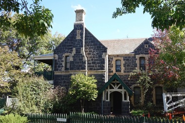
Article - Little Cromer, Kooyong Road, 235, Elsternwick
... Street Neringa Langdon Charles Petley Sadleir John Schreiber ...Photocopied article from Australian Jewish News April 20, 2001 titled A Rich History on the property Little Cromer, 235 Kooyong Road Elsternwick, which is to be auctioned on April 29, 2001. Includes one exterior and one interior photograph. Also includes print of entry for Bellecourt, 85 Seymour Road from Victorian Heritage Database which notes that Little Cromer was formerly called Neringakooyong road, elsternwick, little cromer, hughes allan, hughes marjorie, air raid shelters, beemery park, langdon henry, langdon montague, renwick samuel, blanche street, neringa, langdon charles petley, sadleir john, schreiber robert henry, architect, auctions, roof, gables, stables, gary peer and associates, parsons charles, moloney james, trezise alex, vassy albert, johnston mr., johnston mrs., bellecourt -
Glen Eira Historical Society
Letter - Bewdley Street, 8, Ormond
... Bampfield Charles Percy Houses Timber houses Letter Bewdley Street ...A copy of a three page letter, dated 01/05/1957, sent by S P Simmonds to Plante and Henty Solicitors, concerning the valuation and inspection of the property at Bewdley Street, 8, Ormond. Includes information about the property, property measurements and improvements.bewdley street, ormond, bampfield charles percy, houses, timber houses -
 Federation University Historical Collection
Photograph, Clare Gervasoni, Former Ballarat Courthouse, Camp Street, 13/05/2021
... Sherriff's Office Camp Street Arts Academy Charles Shoppee C.C ...Photographs of the Former Sherriff's Office, Camp Street, BallaratThis stone was laid by the Mayor C.C. Shoppee M.L.A. 21st August. 1903former sherriff's office, camp street, arts academy, charles shoppee, c.c. shoppee -
 Eltham District Historical Society Inc
Photograph, Clearing land for Le Pine Funeral Home, cnr York Street and Main Road, Eltham, c.March 1998, 1998
... street c.r. nicholls charles cockcroft grocery store Kodak Gold ...Newsletter No. 116, September, 1997 846-848 MAIN ROAD ELTHAM Nillumbik Shire Council has granted a permit for a funeral parlour on land which includes this site at the corner of Main Road and York Street. The site contains an architect's office in a building which was formerly a shop and dwelling dating from the 1920's. The proposal requires demolition of this building which is one of the few remaining old shops which formed the rather spread out "town centre" of Eltham. Prior to making its decision the Council obtained a report from Graeme Butler and Associates, the heritage consultants who carried out Stage 1 of the Nillumbik Heritage Study. The report summarized the historical significance as follows:- "This brick comer shop with associated residence has potential local historical significance as a late 1920's grocer's shop, now much altered and one of only a few shops of that era left in Eltham's Main Road. This significance is qualified by the many changes. The other examples are better preserved and still function as shops." With this type of expert advice it is difficult to make a strong case for preservation of the building although, of course, it is a shame to see it demolished. The report includes details of the site itself and its history based on research carried out by Carlotta Kellaway. The building dates from the late 1920's when it was owned by C.R. Nicholls. From the early 1930's it was Charles Cockroft's grocery shop and he also ran a grain store there. According to his daughter, Edna Brown, he delivered groceries around the district taking his truck as far as Kangaroo Ground. In 1950 he shifted to Traralgon. Since then several different businesses have operated from the site including a bottle merchant and produce store. Conversion to the present office use involved alterations to the shop front and rebuilding the galvanized iron store at the rear. Newsletter 119 March 1998 In our Newsletter No. 116 it was reported that the former shop on the comer of Main Road and York Street, Eltham was to be demolished as part of a funeral parlour development. If you have passed the site recently you will have noticed that it has now been demolished - another part of the old Eltham township has disappeared.Roll of 35mm colour negative film, 6 strips Also photographic prints 10 x 15 cmKodak Gold 200-6a.r. warren, eltham feed store, le pine funeral home, main road, york street, c.r. nicholls, charles cockcroft, grocery store -
Glen Eira Historical Society
Letter - Elsternwick
... of Danthorpe U.K. Atkinson Jeff Parkside Street Elsternwick Ebden ...A letter from Jeff Atkinson dated 05/06/1997, relating his research on the name Elsternwick and two photocopied photos of the name, taken in England. Two copied pages from BULMERS 1892 on Elsternwick Township, another page c.1871 and dated maps 1786, with Elsternwick/ Elstronwick in the parish of Danthorpe U.K.atkinson jeff, parkside street, elsternwick, ebden charles hotson, elster, elstronwick, caulfield -
 Flagstaff Hill Maritime Museum and Village
Plan - Lines Plan, S.S. Rowitta, ca 1909
... charles street wharf,... s.s. rowitta charles street wharf, launceston. purdon & ...The lines plan was drawn for the building of the steamship S.S. Rowitta, a passenger steam ferry built in Hobart for use in Tasmania's rivers, the Derwent and the Tamar. It is a copy of the original lines plan. The S.S. Rowitta was built by Purdon & Featherstone, at Battery Point, Hobart (Tasmania) in 1909 from Huon Pine and Kauri planking. Her final configuration included three masts and a ship rig. S.S. Rowitta took its first voyage from Hobart to Launceston in 1909 and operated for 30 years as a passenger ferry on the Tamar and Derwent Rivers. She also served as a freighter, an army supply ship, a luxury charter ferry and a floating restaurant as well as a prawn boat at Lakes Entrance. (She has also been named “Sorrento” and “Tarkarri”.). In the very early days of Flagstaff Hill ‘Rowitta’ was purchased from Lakes Entrance by Warrnambool City Council and the Victorian State Government for $20,000. The Rowitta had a hull configuration very similar to a local boat named the SPECULANT, which played a key role in the Port of Warrnambool in the early 1900s. The Speculant was the largest ship ever registered with Warrnambool as her home port. Local owner and trader P J McGennan & Co, (Peter McGennan) used her as a freight carrier to Melbourne and timber trader between New Zealand and Victoria. She sunk at Cape Otway in 1911 on a voyage to Melbourne. In 1974 Rowitta was delivered to Port Fairy and then later sailed to Warrnambool’s Breakwater where she was lifted out of Lady Bay and loaded onto the back of a long transport truck and slowly and carefully driven along Pertobe Road, through the Surfside Caravan Park and over the railway line, into Flagstaff Hill’s Maritime Village. Transfer arrangements were coordinated by Jack Morse, of Morse Engineering, a member of the Flagstaff Hill Planning Board, and Ken Goyen, a local crane operator. The ‘Rowitta’ was originally acquired to be rebuilt to match the original SPECULANT. When finances became tight in 1976 a review of all plans ended in the decision to restore the “Rowitta” to her original configuration. She was then restored, renamed the original name of “Rowitta” and installed in the Village’s Harbour Lake to become one of the popular vessels on display for visitors to enjoy. It was the decision of the Advisory Committee to Flagstaff Hill to have Rowitta demolished in April 2015 due to extensive deterioration. Items associated with the Rowitta continue to be held in Flagstaff Hill Maritime Village’s Collection.The lines plan of the passenger ferry S.S. Rowitta.is significant for its association with Tasmanian history from the early to mid-1900s. It is also connected to the history of the Rowitta, which was a large exhibit on display at Flagstaff Hill Maritime Village from the museum’s early beginnings until the vessel’s end of life 40 years later. The Rowitta represents the importance of coastal traders to transport, trade and communication along the coast of Victoria, between states, and in Australia before rail and motor vehicles. The vessel was an example of a ferry built in the early 20th century that served many different roles over its lifetime of over 100 years. Lines Plan, copy, of the steamship S.S. Rowitta. Rectangular drawing paper with copy of the hand drawn lines plan showing several profiles of the vessel. The vessel was built in 1909 by Purdon & Featherstone, Hobart. On the revers is handwritten inscription, and a white label with a handwritten number.Printed on the plan: "S.S. ROWITTA / LINES PLAN / SCALE 1/4" TO 12" " Blue ink writing on the back: "Rowitta" Blue ink on label: "56"flagstaff hill, warrnambool, shipwrecked-coast, flagstaff-hill, flagstaff-hill-maritime-museum, maritime-museum, shipwreck-coast, flagstaff-hill-maritime-village, photograph, s.s. rowitta, charles street wharf,, launceston., purdon & featherstone, rowitta, tarkarri, speculant, purdon & featherstone of hobart, passenger ferry 1909, sorrento, lines drawing, ship's plan, lines plan, line plan, shipbuilding, ferry -
 Flagstaff Hill Maritime Museum and Village
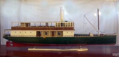
Craft - Ship Model, S.S. Rowitta
... Charles Street Wharf Launceston... Charles Street Wharf Launceston Sorrento remote control boat ...This remote-controlled ship model was made by the blacksmith at Flagstaff Hill Maritime Village in the likeness of the Village's display passenger ferry, the S.S. Rowitta. SS ROWITTA: - The 1909 steam ferry, SS Rowitta, was installed as an exhibit at Flagstaff Hill in 1975 and was enjoyed by many visitors for 40 years. Rowitta was a timber steam ferry built in Hobart in 1909 using planks of Huon and Karri wood. She was a favourite of sightseeing passengers along Tasmania’s Tamar and Derwent rivers for 30 years. Rowitta was also known as Tarkarri and Sorrento and had worked as a coastal trading vessel between Devonport and Melbourne, and Melbourne Queenscliff and Sorrento. In 1974 Rowitta was purchased by Flagstaff Hilt to convert into a representation of the Speculant, a historic and locally significant sailing ship listed on the Victorian Heritage Database. (The Speculant was built in Scotland in 1895 and traded timber between the United Kingdom and Russia. Warrnambool’s P J McGennan & Co. then bought the vessel to trade pine timber from New Zealand to Victorian ports and cargo to Melbourne. She was the largest ship registered with Warrnambool as her home port, playing a key role in the early 1900s in the Port of Warrnambool. In 1911, on her way to Melbourne, she was wrecked near Cape Otway. None of the nine crew lost their lives.) The promised funds for converting Rowitta into the Speculant were no longer available, so she was restored back to her original configuration. She represented the importance of coastal traders to transport, trade and communication in Australian times before rail and motor vehicles. Sadly, in 2015 the time had come to demolish the Rowitta due to her excessive deterioration and the high cost of ongoing repairs. She had given over 100 years of service and pleasure to those who knew her. The remote-controlled model of the S.S. Rowitta is significant for its association with the Tasmanian early to mid-1900s passenger ferry, the wooden screw steamer Rowitta. It is is connected to the history of the Rowitta, that was a large exhibit on display at Flagstaff Hill Maritime Village from the museum’s early beginnings until the vessel’s end of life 40 years later. The display was used as an aid to maritime education. The Rowitta represents the importance of coastal traders to transport, trade and communication along the coast of Victoria, between states, and in Australia before rail and motor vehicles. The vessel was an example of a ferry built in the early 20th century that served many different roles over its lifetime of over 100 years. Model of the wooden steam ferry "S.S. Rowitta". This is a radio-controlled model built by the Flagstaff Hill blacksmith.flagstaff hill, warrnambool, shipwrecked coast, flagstaff hill maritime museum, maritime museum, shipwreck coast, flagstaff hill maritime village, great ocean road, ship model, remote controlled steam ship model, s.s. rowitta, tarkarri, speculant, purdon & featherstone of hobart, passenger ferry 1909, tasmanian passenger ferry, vessel, charles street wharf launceston, sorrento, remote control boat, rowitta model, remote-controlled model -
 Flagstaff Hill Maritime Museum and Village
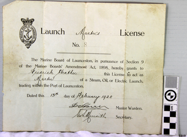
Document - License, Marine Board of Launceston, Launch Master's Licence, 13-02-1920
... Charles Street Wharf Launceston... vessel Charles Street Wharf Launceston Sorrento Handwritten ...The Launch Master Frederick Heather was licensed to be Master of Launches within the Port of Launceston. Amongst the vessels that he captained was the S.S. ROWITTA. Fredrick’s son is one of the volunteers at the Low Head Pilot Station Museum, Frederick Heather is also related to a Harry Heather from Tasmania and was also a ship master, one of his ships being the "Alma Doepel", a sailing schooner built in 1903 and sailed by Harry for about 21 years until his death in 1937. Flagstaff Hill’s collection includes a painting of the Alma Doepel. SS ROWITTA: - The 1909 steam ferry, SS Rowitta, was installed as an exhibit at Flagstaff Hill in 1975 and was enjoyed by many visitors for 40 years. Rowitta was a timber steam ferry built in Hobart in 1909 using planks of Huon and Karri wood. It was a favourite of sightseeing passengers along Tasmania’s Tamar and Derwent rivers for 30 years. Rowitta was also known as Tarkarri and Sorrento and had worked as a coastal trading vessel between Devonport and Melbourne, and Melbourne Queenscliff and Sorrento. In 1974 Rowitta was purchased by Flagstaff Hilt to convert into a representation of the Speculant, a historic and locally significant sailing ship listed on the Victorian Heritage Database. (The Speculant was built in Scotland in 1895 and traded timber between the United Kingdom and Russia. Warrnambool’s P J McGennan & Co. then bought the vessel to trade pine timber from New Zealand to Victorian ports and cargo to Melbourne. It was the largest ship registered with Warrnambool as her home port, playing a key role in the early 1900s in the Port of Warrnambool. In 1911, on her way to Melbourne, it was wrecked near Cape Otway. None of the nine crew lost their lives.) The promised funds for converting Rowitta into the Speculant were no longer available, so it was restored back to its original configuration. The vessel represented the importance of coastal traders to transport, trade and communication in Australia times before rail and motor vehicles. Sadly, in 2015 the time had come to demolish the Rowitta due to her excessive deterioration and the high cost of ongoing repairs. The vessel had given over 100 years of service and pleasure to those who knew her. The licence is significant for its association with the Tasmanian early to mid-1900s passenger ferry, the S.S. Rowitta. It is connected to the history of the Rowitta, which was a large exhibit on display at Flagstaff Hill Maritime Village from the museum’s early beginnings until the vessel’s end of life 40 years later. The display was used as an aid to maritime education. The Rowitta represents the importance of coastal traders to transport, trade and communication along the coast of Victoria, between states, and in Australia before rail and motor vehicles. The vessel was an example of a ferry built in the early 20th century that served many different roles over its lifetime of over 100 years. Launch Master's License No 8 issued to Fredrick Heather to act as Master of a steam, oil or electric launch trading within the Port of Launceston. Date issued 13th February 1920. The license is printed with hand written details added.Handwritten on License "Master's" "Frederick Heather" "Master" "13th February 1920" Also two signatures (indecipherable) of Master Warden and Secretary.flagstaff hill, flagstaff hill maritime museum and village, warrnambool, maritime museum, maritime village, great ocean road, shipwreck coast, launch master's licence, rowitta, frederick heather, port of launceston, launch master's license, marine board of launceston, tarkarri, speculant, purdon & featherstone of hobart, passenger ferry 1909, vessel, charles street wharf launceston, sorrento -
 Yarra Glen & District Historical Society
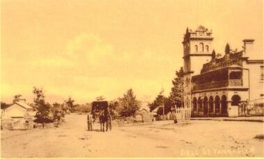
Sepia postcards, Bell St Yarra Glen
... vehicle bell street tree guards charles bath On back of postcard ...Sepia postcard view of Yarra Glen taken from the top of hill near hotel in Bell St looking south. On left hand side is a shop behind which is Victoria Hall. In centre of the road is horse and wagon presumed to be owned by Charles Bath. On right hand side is the Grand Hotel. Unpaved road. Mount Dandenong in the distance.On back of postcard at the top "POST CARD". On the left hand side "THIS SPACE MAY BE USED FOR PRINTED OR WRITTEN MATTER". On the right hand side "ONLY THE ADDRESS TO BE WRITTEN HERE". In a box in the right hand corner "A HALF-PENNY STAMP TO BE PLACED HERE". Along the left hand margin "Ajax series. Printed in England". Handwritten in pencil "$12"hotel, yarra glen, grand hotel, victoria hall, horse drawn vehicle, bell street, tree guards, charles bath -
 Yarra Glen & District Historical Society
Black and white photographs, Bell Street Yarra Glen
... -ranges grand hotel bell street tree guards charles bath general ...Photograph taken from the corner of King Street and Bell Streets Yarra Glen with a view of buildings on the western side of Bell Street from Scott & Allen's General Store to the Colonial Bank building. Other buildings include the house of Charles Bath and the Grand Hotel. Tree guards line the street.grand hotel, bell street, tree guards, charles bath, general store, scott allen s general store, colonial bank, bank building, hotels -
 City of Moorabbin Historical Society (Operating the Box Cottage Museum)
Flyer - Kinrade Estate, Bentleigh East
... Charles Street... of Moorabbin Leary Avenue Charles Street Peter Leary John Joseph ...Kinrade Estate was not subdivided as shown in flyer. The land was purchased by Cyclone in 1950. Cyclone built a factory which manufactured wire material. This factory was closed in XXXX and a development firm purchased the land and subdivided the land into housing blocks.Example of the progress of the Municipality of MoorabbinAdvertising flyer for auction of real estate sales - plan of building blocks for saleleary avenue, charles street, peter leary, john joseph kinrade, tucker road, east boundary road, clover estate, kinrade estate, bentleigh, cyclone company, ardena court, bentleigh east -
 Kew Historical Society Inc
Document (item) - Invitation, City of Kew, Official Opening of Kew Municipal Offices, 1973
... kew town hall -- charles street -- kew (vic.)... invitations -- kew (vic) kew town hall -- charles street -- kew (vic ...The Municipality of Kew (1860-1863), the Borough of Kew (1863-1910), the Town of Kew (1910-1921) and the City of Kew (1921-1994) were local government instrumentalities in the State of Victoria. In 1994, the City of Kew was amalgamated, together with the former Cities of Camberwell and Hawthorn, into the new City of Boroondara (1994- ). Like other local government entities of the period, Kew was administered by town clerks. The two notable town clerks in Kew's history were H. H. (Henry Hirst) Harrison (1868-1955) and W. D. (William Dickie) Birrell (1899-1974). Harrison was appointed to the position in 1901 and retired in 1938 after 37 years. Birrell, appointed Acting Town Clerk in 1921, became Town Clerk in 1938, following Harrison's retirement. He continued in this role until his retirement in 1966.This card is part of an historically significant civic collection, containing hundreds of separate invitations, documents, greeting cards, programmes and tickets issued and/or collected by successive town clerks. Items in the collection illuminate the political, social and cultural history of the district. As a continuous record, ranging across most decades of the Twentieth Century, they reveal changing tastes in design, values and relationships in the history of local government in Victoria.OFFICIAL OPENING OF KEW MUNICIPAL OFFICES / BY / THE HONOURABLE R J HAMER, PREMIER OF VICTORIA / THE MAYOR AND COUNCILLORS OF THE CITY OF KEW / REQUEST THE PLEASURE OF THE COMPANY OF / ___________ / OFFICIAL OPENING OF THE NEW MUNICIPAL OFFICES & LIBRARY / KEW CIVIC CENTRE / THURSDAY, 22ND MARCH, 1973, 3 P.M./ RSVP TOWN CLERK , KEW 8TH MARCH, 1973 / ON RECEIPT OF ACCEPTANCE ENTREE CARDS WILL BE FORWARDEDcivic invitations -- kew (vic), kew town hall -- charles street -- kew (vic.), kew civic offices -
Surrey Hills Historical Society Collection
Folder of real estate advertisements, Folders of real estate advertisements (Streets beginning with C), Various
... charles street... carson avenue charles street chertsey street chester street ...A4 folders with individual pockets for each property in streets beginning with C located in Surrey Hills and Mont Albert. Folders are ordered by street name and then chronologically by property number. Each property has its own pocket. This may include multiple real estate advertisements collected from sales over time. It may also include copies of any research undertaken by Alan Holt and / or members of the SHNCHC team. These are augmented by cards in the Alan Holt index file and by his property registers of Surrey Hills and Mont Albert.canterbury road, carlyle crescent, carson avenue, charles street, chertsey street, chester street, chestnut street, churchill street, clyde street, como avenue, croydon road, curlewis street -
 Greensborough Historical Society
Poster - Planning Document, City of Heidelberg, Subdivision Plan # G 27, Greensborough and Diamond Creek, 1922 and 1963
... Street, Nepean Street, Charles Street, 1922. Side 2: 2 plans... Street, Nepean Street, Charles Street, 1922. Side 2: 2 plans ...Plan of Subdivisions in City of Heidelberg: Side 1: 2 plans, Parish of Keelbundoora: plan 1: Henry Street, Vermont Avenue, Lyell Street, Nell Street, McDowell Street, 1922. Plan 2: Henry Street, Nepean Street, Charles Street, 1922. Side 2: 2 plans Parish of Nillumbik, Portion 13: Plan 1: Diamond Creek Road, Delfin Crescent, Ridge Road, 1963. Plan 2: Kinglake Road, Eltham Road, 1963.An example of hard copy subdivision plans from the Greensborough area. Mainly from the Shire of Diamond Valley era (1964-1994).Plan (2 sided) mounted on heavy card. Contains 2 sheets pasted together.Stamped and handwritten Council permissions, dates and other details.subdivision plans, city of heidelberg -
 Warrnambool and District Historical Society Inc.
Booklet - Florist Booklet, Modern Print Warrnambool, The Floral Farm Warrnambool Flower Seedling List 1926, 1926
... Streets. Charles Jukes died in 1934 but the nursery was still... Street (south of Merri St) Warrnambool great-ocean-road ...A business booklet of plants for sale and seasonal suggestions for planting.This booklet has sixteen pages with gold and blue printing on the white cover. The pages contain printed material. The pages have been stapled but the staples have been removed.non-fictionA business booklet of plants for sale and seasonal suggestions for planting.warrnambool plant nurseries, charles jukes -
 Bendigo Historical Society Inc.
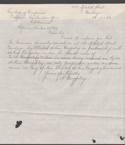
Document - BAGGALEY COLLECTION: HAND WRITTEN LETTER ADVISING REGISTRAR OF COMPANIES ADVISING OF CHANGE OF OWNERSHIP OF PREMISES
... at 255 Mitchell Street from Charles Arthur Baggaley & Son... at 255 Mitchell Street from Charles Arthur Baggaley & Son ...Hand written advice from A. Baggaley that the premises at 255 Mitchell Street from Charles Arthur Baggaley & Son, is from 22/02/1963 operated by Arthur Baggaley as sole proprietor following death of C. A. Baggaley -
 Federation University Historical Collection
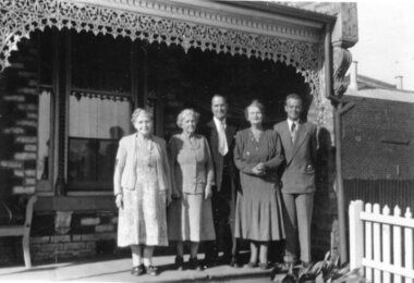
photograph - Black and White, Kate Braithwaite (nee Wright), Eileen, Laura, 54 Charles St St Kilda, 1940 S
... Three women stand on the verandah of 54 Charles Street, St... ritchie Three women stand on the verandah of 54 Charles Street, St ...Three women stand on the verandah of 54 Charles Street, St Kilda. They are Kate Braithwaite (nee Wright), Eileen, Laura Wrightkate braithwaite, kate wright, frank wright, st kilda, laura wright, laura ritchie -
 Kew Historical Society Inc
Photograph - Digital Photograph, Robert Baker, Vicarage of Holy Trinity Church (Kew), 2013
... in Pakington Street (Kew), designed by Charles Vickers. ... in Pakington Street (Kew), designed by Charles Vickers. Vicarage ...The Vicarage at Holy Trinity Church in Kew faces Pakington Street. It was designed by the architect Charles Vickers. Th building has been 'restored' at various stages in the 20th century.Born digital image of the facade of the bluestone vicarage in Pakington Street (Kew), designed by Charles Vickers. holy trinity church - kew (vic), churches - vicarages - kew (vic), charles vickers -
 Glenelg Shire Council Cultural Collection
Photograph - Photograph - Panorama, 1987
... bay. Shows History House, Cannons, Charles Street, War... House, Cannons, Charles Street, War Memorial and Court House ...Panorama of 7 colour photos. View of Municiple Offices over bay. Shows History House, Cannons, Charles Street, War Memorial and Court House.Back: For History House - Taken 1987 while employed as cleaner for City Council/Regards/Robert (?) Morris.... (?) (blue pen, upper centre) -
 Kew Historical Society Inc
Photograph, Kew RSL, Cotham Road, circa 1965, c. 1965
... and Charles Street, Kew. Designed by Guyon Purchase for Dr. William...?)" The exterior of the Kew RSL on the corner of Cotham Road and Charles ...The Kew RSL is located in "Wilton" House, 63 Cotham Road. The RSL was established on January 1st 1920, later joining with the Hawthorn RSL. In November 1931, Cr. C.R. Parry organised the reformation of the Kew Sub Branch and its first president was Brig-Gen Pat McGlin, a veteran of the Boer War and the First World War. On July 17th 1932, the club rooms first opened on Army land at the corner of High Street and Highbury Grove. In late November 1948, the Kew RSL bought the "Wilton" house from the Kew City Council for £10,067, opening seven years later in July 1955. [Source: Victorian Heritage Database]This work forms part of the collection assembled by the historian Dorothy Rogers, that was donated to the Kew Historical Society by her son John Rogers in 2015. The manuscripts, photographs, maps, and documents were sourced by her from both family and local collections or produced as references for her print publications. Many were directly used by Rogers in writing ‘Lovely Old Homes of Kew’ (1961) and 'A History of Kew' (1973), or the numerous articles on local history that she produced for suburban newspapers. Most of the photographs in the collection include detailed annotations in her hand. The Rogers Collection provides a comprehensive insight into the working habits of a historian in the 1960s and 1970s. Together it forms the largest privately-donated collection within the archives of the Kew Historical Society.The exterior of the Kew RSL on the corner of Cotham Road and Charles Street, Kew. Designed by Guyon Purchase for Dr. William Walsh in 1886, the building was originally called Wilton."Chap 59. Cotham Rd. Built/Commences about 1885-6. Present day Wilton . Kew RSSUILA rooms. (Rumour of sale 1972?)"wilton, dr william walsh, guyon purchas, dorothy rogers, cotham road (kew) -
 Kew Historical Society Inc
Photograph, 'Roberts House', Trinity Grammar School, c. 1965
... street, and Charles street, Kew, which adjoins the property... street, and Charles street, Kew, which adjoins the property ...The Argus in November 1924 reported the purchase of Elsinore by Trinity Grammar School. "The council of Trinity Grammar School, Kew, has purchased Elsinore, the residence of the late Mr. V. J. Saddler, at the corner of Wellington street, Stanley street, and Charles street, Kew, which adjoins the property recently purchased from Mr. J. Henning Thompson (known as 'Trinity Lodge), and is directly opposite the Headmaster's house and main school grounds.This work forms part of the collection assembled by the historian Dorothy Rogers, that was donated to the Kew Historical Society by her son John Rogers in 2015. The manuscripts, photographs, maps, and documents were sourced by her from both family and local collections or produced as references for her print publications. Many were directly used by Rogers in writing ‘Lovely Old Homes of Kew’ (1961) and 'A History of Kew' (1973), or the numerous articles on local history that she produced for suburban newspapers. Most of the photographs in the collection include detailed annotations in her hand. The Rogers Collection provides a comprehensive insight into the working habits of a historian in the 1960s and 1970s. Together it forms the largest privately-donated collection within the archives of the Kew Historical Society.The central tower of Roberts House (originally 'Elsinore'), Wellington Street, Kew. Part of Trinity Grammar School since 1924.4. Roberts House. Trinity Grammar School.roberts house, trinity grammar school, elsinore -
 Kew Historical Society Inc
Photograph - Former Kew Town Hall, Walpole Street, 1972
... of Cotham Road and Charles Street in 1972.... of the (former) Kew Town Hall in Walpole Street between High Street... Civic Centre on the corner of Cotham Road and Charles Street ...The Municipality of Kew was granted independence in 1860. It was declared a borough in 1863, a town in 1910 and a city in 1921. In 1994, Kew was amalgamated into the new City of Boroondara. In 1960, a new Town Hall in Cotham Road was opened. The Municipal Offices that had remained in the former Town Hall in Walpole Street until it was moved to the new Civic Centre on the corner of Cotham Road and Charles Street in 1972.This is a rare and important colour photograph of the Kew Municipal Offices (former Town Hall) taken on 11/2/1972 in the year that the building was demolished and replaced by a Safeway Supermarket.Colour photographic positive (polaroid) of the front of the (former) Kew Town Hall in Walpole Street between High Street and Malmsbury Street, on the west side where Woolworth's supermarket now stands. The photograph, taken in February 1972, shows the detailing of the Italianate rendered-brick facade, added in the 1880s when the hall was renovated. The earliest building on the site was the Kew Athenaeum Hall (built 1860) which was purchased by Kew Council in 1865. The Town Hall was sold to Woolworth's and subsequently demolished in 1972 when the civic offices were transferred to a new building on the corner of Charles Street and Cotham Road.kew town hall -- walpole street, local government -- kew, town halls -- melbourne (vic.) -
!['Reno', St John's Parade [Kew]](/media/collectors/550653872162f11fb04854aa/items/658d16120f23e8f1e738df53/item-media/658d16680f23e8f1e738e098/item-fit-380x285.jpg) Kew Historical Society Inc
Kew Historical Society IncPhotograph - 'Reno', St John's Parade [Kew], c. 1965
... , and Charles Street. The garden including rare plants supplied by Baron..., and Charles Street. The garden including rare plants supplied by Baron ...‘Reno’, stood on the east side of St John’s Parade. Its earliest recorded owner was the architect Samuel Cocking who lived there from c.1865 until his death in 1888. The original landholding was bordered by Cotham Road, Glenferrie Road, Wellington Street, and Charles Street. The garden including rare plants supplied by Baron Von Mueller, surrounds the cottage in a tangled frenzy. Despite a ‘local significance’ classification by the National Trust, the house was demolished in 1977.This work forms part of the collection assembled by the historian Dorothy Rogers (1905-1973), donated to the Kew Historical Society by her son in 2015. The manuscripts, photographs, maps, and documents were sourced by her from both family and local collections or produced as references for her print publications. Many were directly used by Rogers in writing ‘Lovely Old Homes of Kew’ (1961) and 'A History of Kew' (1973), or the numerous articles on local history that she produced for suburban newspapers. Most of the photographs in the collection include detailed annotations in her hand. The Rogers Collection provides a comprehensive insight into the working habits of a historian from the 1960s to the 1970s. Original monochrome photograph of Reno, St John's Parade, Kew. Pictured are the garage in the distance at left, the weatherboard house with its simple verandah, and the overgrown front garden.Annotation verso: "Reno. St Johns Parade. Reno. Miss Green".dorothy rogers, reno.-- st john's parade (kew) -
 Robin Boyd Foundation
Document - Manuscript, Robin Boyd, The Melbourne Book, 1966
... Hoddle and design impetus; naming of gridiron streets; Charles... Hoddle and design impetus; naming of gridiron streets; Charles ...Description of first grid drawn of Melbourne by Robert Hoddle and design impetus; naming of gridiron streets; Charles Troedel prints/The Melbourne Album, F. Cogne drew Melbourne scenes on lithographic stones; Harold Freedman drew same scenes of Melbourne 1964/65; comparative discussion of Melbourne then and now; between 1865-1965 substantial buildings erected and demolished; cable tram; strength and delicacy of Melbourne style; first tree planting; first electric tram 1927; lifting of building height limits 1956; list of representative buildings; Melbourne unlike other capitals as it was not conceived as a capital city.Published as a chapter titled 'The Town at Port Phillip' in 'The Book of Melbourne and Canberra', The Griffin Press, Adelaide 1966Typewritten (c copy), quarto, 14 pagesjohn batman, john fawkner, robert russell, robert hoddle, charles troedel prints/the melbourne album, f. cogne; cable trams; building height limits; tree planting; electric tram 1927; representative buildings, robin boyd, manuscript -
Kew Historical Society Inc
Archive (Sub-series) - Subject File, BON, Ann (1838-1936), 1958
... -1936) who for a period lived in Charles Street and is buried... in Charles Street and is buried in the Boroondara General Cemetery ...Various PartiesReference, Research, InformationKHS OrderSubject file containing information about Ann Bon (1838-1936) who for a period lived in Charles Street and is buried in the Boroondara General Cemetery. The file includes correspondence, printed articles, and typed secondary sources. ann bon, william barakann bon, william barak -
![Section of mural from the ballroom of 'Ordsall' [Southesk], Cotham Road](/media/collectors/550653872162f11fb04854aa/items/57295b902162f108e8d6367a/item-media/614c29d34739c077d925ddc5/item-fit-380x285.jpg) Kew Historical Society Inc
Kew Historical Society IncPainting - Section of mural from the ballroom of 'Ordsall' [Southesk], Cotham Road, Cullis Hill & Co, 1882
... at the corner of Cotham Road and Charles Street, Kew. This triangular... once stood at the corner of Cotham Road and Charles Street, Kew ...Ordsall, renamed Southesk in the 20th century was built for John Halfey in or before 1865. The house was rebuilt in the 1870s to designs by architect Michael Hennessy. In 1882 the house was redecorated by the firm of Culls Hill & Co., who hired the artists 'Mr Vandenbrandt' and 'Signor Rizzi" to paint the ceilings of the ballroom and the drawingroom. The artistic triumph was described in detail in The Argus, 30 October, 1882. In 1947, Southesk was purchased by the Kew City Council. For 23 years it was used as a meeting place for community groups. The house was then demolished in 1970 to make way for a new Town Hall.The interiors of the two main reception rooms at Ordsall included some of the most outstanding domestic frescos painted in Australia in the late Victorian period. These frescos were executed by artists hired by the firm of Cullis Hill & Co. While a number of photographs were taken of the interiors prior to the house's demolition in 1970, this small fragment of the fresco is one of only three extant. The fresco allows conservators to examine and evaluate fresco techniques of the period.One of only two fragments of the painted domed ceiling of the ballroom of Ordsall (later renamed Southesk) which once stood at the corner of Cotham Road and Charles Street, Kew. This triangular piece of the fresco is of a cherub's face.Label: 'This is from the "Southesk" ballroom 14-7-70'ordsall, southesk, cullis hill & co. -
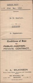 Bendigo Historical Society Inc.
Document - H.A. & S.R. WILKINSON COLLECTION: CONDITION OF SALE
... situate in Charles Street, Bendigo, together with 5-roomed... in Charles Street, Bendigo, together with 5-roomed weatherboard ...Conditions of sale by private contract dated 22nd May, 1930 between D.K Doxford (seller) and G. Rasmussen (buyer) for land situate in Charles Street, Bendigo, together with 5-roomed weatherboard dwelling and all sundry. Price 440 pounds.organization, business, h.a. & s.r wilkinson real estate -
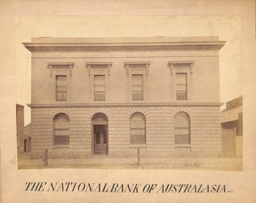 Port Melbourne Historical & Preservation Society
Photograph - Port Melbourne, The National Bank of Australasia, c 1890s
... the alterations had been completed. A photograph of Bay Street by Charles... completed. A photograph of Bay Street by Charles NETTLETON from ...The National Bank of Australasia in Bay Street was designed by Leonard TERRY of Terry and Oakden, Architects and built in 1874. In 1889, architect George JOBBINS designed an extension of the southern end of the building. This photograph was taken after the alterations had been completed. A photograph of Bay Street by Charles NETTLETON from around 1878 (Cat No 178) shows the bank as it was originally built.Photograph of the facade of the National Bank of Australasia taken probably in the 1890s - Bay Street, Port MelbourneReceived from Port Melbourne Library 16/7/1973built environment - commercial, business and traders, national bank of australasia.