Showing 4074 items matching " surveying"
-
 Bendigo Historical Society Inc.
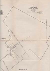
Map - COMET MINE - PLAN OF COMET MINE
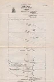
Plan of the Comet Mine on the Hustler's Line of Reefs Bulletin No 33, Plate No XXIV signed by H S Whitelaw, Underground Survey Office Bendigo, September 1913. Upper and Lower Levels and approximate boundaries shown. Depths shown.Geological Survey of Victoriamining, parish map, hustler's line of reefs, comet mine plan bulletin no 33 plate no xxiv -
 Falls Creek Historical Society
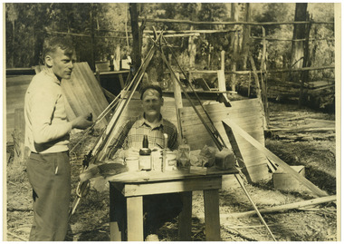
Photograph - Big River Survey Camp, c1949
MEYER COLLECTION - FALLS CREEK PHOTOS In 1947 a determined group of like-minded State Electricity Commission (SEC) staff including Ray Meyer, the chief surveyor of the Kiewa Hydro-Electric Scheme, had a common interest that revolved around the skiing potential of the snow-covered high plains which included what is now the resort of Falls Creek. The six SEC employees, Toni St Elmo, Ray Meyer, Jack Minogue, Lloyd Dunn, Adrian Ruffenacht and Dave Gibson (together with their families) banded together to secretly build a 'hut' that was the first ski lodge at Falls Creek. Using a road built in 1930s to gain access to Falls Creek, their hut project was carried out in secret as efforts by other skiers were blocked by H.H.C. Williams – the engineer in charge of the Hydro Scheme. In 1946 Ray Meyer made a trip to the Lands Office in Melbourne. He came away with a 99-year lease on three acres that was ideally suited for a hut designed by Lloyd Dunn. Adrian Ruffenacht (Design Engineer for the KHS) had suggested where the group should build because of easy access to a spring for water. Much of the building material required was scavenged from derelict huts on the high plains. Due to the need for secrecy, the determined group worked on the hut in the evenings and weekends to avoid detection. During the building period the group had met at Echidna Rock (now known as Eagle Rock) where Skippy St Elmo announced, "This is my favourite ‘Skyline’.” And so the first lodge in the area at Falls Creek Ski Resort came into existence. With the development of the International Poma in the 1970s, the Skyline Lodge, which was sited between the ski-lift’s pole one and pole two, was demolished. However, the legacy of Ray Meyer, Toni St Elmo, Jack Minogue, Lloyd Dunn, Adrian Ruffenacht and Dave Gibson and Skyline lives on in the vibrant atmosphere of Falls Creek Resort. The MEYER COLLECTION documents developments on the Kiewa Hydro Scheme and their life at Falls Creek from the mid 1930s to 1960s.This image is significant because it documents development of the Kiewa Hydroelectric Scheme.Two black and white images at the Big River Old Survey Camp.Photo 1 - Breakfast at Big River Left to RIght Ray Meyer, Wal Johnson Photo 2 - Big River Survey Camp at foot of T Spur C 1949, Kiewa RIver Survey Team.kiewa hydroelectric scheme, ray meyer, wal johnson -
 Bendigo Historical Society Inc.
Map - SECTIONS ACROSS BENDIGO GOLDFIELD
Map in three sections showing sections across Bendigo Gold Field, showing anticlines, synclines, faults, stratigraphical zones and mines along the reef lines. Key shows rock types Castlemaine, Bendigo B1, B2, B3 and B4, and Lancefieldian. First part of map shows sections A-A, B-B and C-C. Reef lines drawn with mines listed: Fault line shown are the Carshalton, Stafford, New Chum, Virginia and Clarence. A datum line shows 600 ft above sea level. On bottom of plan: ' Prepared in the Geological Survey Office, Bendigo, under the direction of H. Herman, late Director of Geological Survey, from surveys by H.S. Whitelaw, Field Geologist, assisted by E.S. Usher, A.J.J. Moore and R.A. Keble.' Second section of map shows sections D-D, and E-E. Fault lines listed are the Tambour Major fault, Carshalton fault, Stafford fault, Nell Gwynne fault, New Chum fault, Deborah fault. Third section shows sections F-F and G-G. Fault lines listed are the Bird Reef fault, Kangaroo Gully fault, Langdon fault, Carshalton fault, Nell Gwynne fault, Spring Gully fault, Hustlers fault, Gravel Hill fault, Ordes fault, Thanet fault. This map forms part of the Geological Survey of Victoria, Structure of Bendigo Goldfield report, No. 47, 1923. H.Herman, late Director of Geological Survey.Geological Survey of Victoriabendigo, gold mining, reef line maps -
 Bendigo Historical Society Inc.
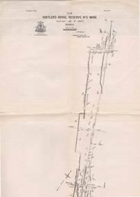
Map - STRUGNELL COLLECTION: HUSTLER'S LINE OF REEFS, BENDIGO, September 1913
Map, Hustler's Line of Reefs, Hustler's Royal Reserve No.2 Mine, Bendigo Plan. Plate No.V1 (6). Bulletin No 33 Signed H.A.Whitelaw Underground survey Office Bendigo September 1913Underground Survey Office, Bendigo.map, bendigo, hustler's royal reserve no. 2 mine* -
 Bendigo Military Museum
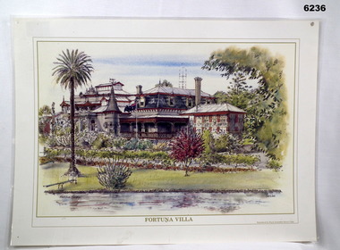
Print - Print of Fortuna Villa by Bill Walls, Bill Walls
Print of a painting by Bill Walls. Fortuna Villa was the home of the Army Survey Regiment from 1942 - 1996. This print was printed by the Army Survey Regiment. A number of prints were produced at various sizes including the Unit Christmas cards.Print on heavy paper, laminated and printed by the Royal Australian Survey Corps, Army Survey Regiment, BendigoLabelled "Fortuna Villa" signed by Bill Wallsroyal australian survey corps, rasvy, fortuna, army survey regiment, army svy regt, asr -
Glenelg Shire Council Cultural Collection
Photograph - Photograph - aerial view of train track between Heywood and Rennick, 03/05/1952
Black and white aerial photographs (aerial survey record print) of the railway line between Heywood and Rennick (S.A. border) Taken for Victorian Railways, May 1952. Some photos have annotations later added to the front of the image in penVictorian Railways aerial survey record print of the railway line between Heywood and Rennick (S.A. border) Black and white, white vertical strip on imageFront: Annotations in red ink added at a later date Back: 'Heywood - Rennick 21579 - 19842 279m 57c ' - all black ink. Purple VR aerial survey stamp. '3 May 1952' - black stampvictorian railways, train track, transport, travel -
 Bendigo Military Museum
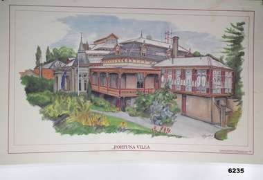
Print - Print of Fortuna Villa by Ruth Edwards, Ruth Edwards, 1991
Print of a painting of Fortuna Villa by Ruth Edwards 1991. Fortuna Villa was the home of the Army Survey Regiment from 1942 - 1996. This print was printed by the Army Survey Regiment. A number of prints were produced at various sizes including Unit Christmas cards. Print of a painting on parchment paper, laminated. printed by the Royal Australian Survey Corps, Army Survey RegimentLabelled "Fortuna Villa" signed by Ruth Edwardsroyal australian survey corps, rasvy, fortuna, army survey regiment, army svy regt, asr -
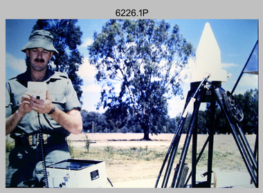 Bendigo Military Museum
Photograph - Demonstration of TI4100 GPS Receiver, Royal Australian Survey Corps, c1988
... surveying ...This is a set of four photographs of WO2 Graham Ragless from the Royal Australian Survey Corps demonstrating the operation of Global Positioning System equipment in c1988. The photos were probably taken at the School of Military Survey (SMS), Bonegilla, VIC. Texas Instruments TI4100 portable Global Positioning System (GPS) geodetic receivers were introduced from 1986–1988. The GPS receivers and Ferranti FILS3 helicopter and vehicle mounted Inertial Positioning System (IPS) replaced the TRANSIT satellite receivers. The equipment was deployed to establish the baseline for a GPS controlled air camera and photogrammetric system to significantly reduce the requirement for ground survey to accurately control air photography for topographic mapping. Personnel from the four field survey squadrons at this time were trained at the SMS to operate the TI4100 receivers. Field survey operations using GPS and IPS equipment followed in the late 1980s. This technology is described in more detail in the RA Svy booklet titled An Introduction to Topographic Mapping. See record ID - 6010. WO2 Graham Ragless progressed to the rank of WO1 and was appointed as RSM of the Army Survey Regiment from 1990 to 1992. Refer to item 6186.2P for more photographs of WO2 Graham Ragless demonstrating the TI4100.This is a set of four photographs of a technician from the Royal Australian Survey Corps demonstrating the operation of Global Positioning System equipment in c1988. Colour photos are on 35mm slide film and were scanned at 96 dpi. .1) to .4) - Photo, colour, c1988, WO2 Graham Ragless demonstrating the operation of a TI4100 GPS receiverThere are no annotations.royal australian survey corps, rasvy, army survey regiment, army svy regt, fortuna, asr, surveying -
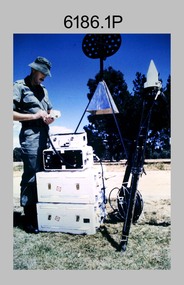 Bendigo Military Museum
Photograph - Demonstration of TI4100 GPS Receiver, Royal Australian Survey Corps, c1988
... surveying ...This is a set of two photographs of WO2 Graham Ragless from the Royal Australian Survey Corps demonstrating the operation of Global Positioning System equipment in c1988. The photos were probably taken at the School of Military Survey (SMS), Bonegilla, VIC. Texas Instruments TI4100 portable Global Positioning System (GPS) geodetic receivers were introduced from 1986–1988. The GPS receivers and Ferranti FILS3 helicopter and vehicle mounted Inertial Positioning System (IPS) replaced the TRANSIT satellite receivers. The equipment was deployed to establish the baseline for a GPS controlled air camera and photogrammetric system to significantly reduce the requirement for ground survey to accurately control air photography for topographic mapping. Personnel from the four field survey squadrons at this time were trained at the SMS to operate the TI4100 receivers. Field survey operations using GPS and IPS equipment followed in the late 1980s. This technology is described in more detail in the RA Svy booklet titled An Introduction to Topographic Mapping. See record ID - 6010. WO2 Graham Ragless progressed to the rank of WO1 and was appointed as RSM of the Army Survey Regiment from 1990 to 1992. Refer to item 6226.4P for more photographs of WO2 Graham Ragless demonstrating the TI4100.This is a set of two photographs of a technician from the Royal Australian Survey Corps demonstrating the operation of Global Positioning System equipment in c1988. Colour photos are on 35mm slide film and were scanned at 96 dpi. .1) and .2) - Photo, colour, c1988, WO2 Graham Ragless demonstrating the operation of a TI4100 GPS receiverThere are no annotations.royal australian survey corps, rasvy, army survey regiment, army svy regt, fortuna, asr, surveying -
Glenelg Shire Council Cultural Collection
Photograph - aerial view of train track between Heywood and Rennick, 03/05/1952
Black and white aerial photographs (aerial survey record print) of the railway line between Heywood and Rennick (S.A. border) Taken for Victorian Railways, May 1952. Some photos have annotations later added to the front of the image in penVictorian Railways aerial survey record print of the railway line between Heywood and Rennick (S.A. border) Black and white, white vertical strip on imageFront: Annotations in red ink added at a later date Back: 'Heywood - Rennick 21578 - 19841 279m 49c Rennick ' - all black ink. Purple VR aerial survey stamp. '3 May 1952' - black stampvictorian railways, train track, travel, transport -
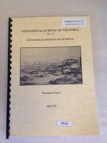 Stawell Historical Society Inc
Book, Norman Taylor, Geological Survey of Victoria No3, Geological Survey of Stawell, 1875-1876
Geological Survey of Stawell 1875/76 by Norman Taylor, Geological SurveyorYellow Card Front and Rear Cover with B/W Picture of mining scene. with black Plastic spineGeological Survey of Victoria No.3 Geological Survey of Stawell Norman Taylor 1875/76stawell mining -
Whitehorse Historical Society Inc.
Map, Subdivision of Allotment 122a, 1972
Subdivision of land along Livermore Close and Moore Road, Vermont South.Subdivision of land along Livermore Close and Moore Road, Vermont South. Original survey Rob Poole 1899. Stamp indicates 'Land on this plan is in proclaimed survey No 21. Survey Coordination Act 1940. As from 9 Aug 1972. Two maps in different scales.Subdivision of land along Livermore Close and Moore Road, Vermont South. land subdivision, livermore close, vermont south, moore road, vermont south, dandenong creek -
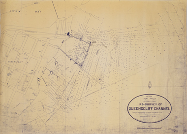 Queenscliffe Maritime Museum
Map - Survey Chart, J. P. Larkin, Re-Survey of Queenscliff Channel, 29 October 1928
... Surveying ...A paper chart showing sounding around the Queenscliff Channel dated 1928Victoria Port Phillip October 1928, Re survey of Queenscliff Channelqueenscliff channel, surveying, navigation -
 Bendigo Military Museum
Photograph - Johnson Ground Elevation Meter (JGEM) Survey Vehicle - Army Survey Regiment, Fortuna, Bendigo, c1960s
... surveying ...This is a set of 16 photograph of the Royal Australian Survey Corps’ Johnson Ground Elevation Meter (JGEM) Survey Vehicle taken at the Army Survey Regiment, Fortuna, Bendigo. The JGEM vehicle was extensively used by RA Svy within Australia from the late 1960s. A limited number of Ground Elevation Meter (GEM) station wagon type vehicles were manufactured by General Motors Corporation (GMC) in the USA for the United States Geological Survey, Canada’s mapping agencies, RA Svy and National Mapping (Natmap). The GEM was a four-wheel drive, four-wheel steer vehicle. Four-wheel steering was necessary to avoid systematic errors caused by non-tracking of front and rear wheels on conventionally steered vehicles. The manufacturer substituted the rear axle with a front axle and connected them to form the four-wheel steering mechanism. The two Australian GEM vehicles, referred to as Johnson GEMs (JGEMs) were converted into right-hand drive. After delivery in 1964, acceptance Natmap and RA Svy testing and operator training was undertaken at the Army's School of Military Survey located at Balcombe, Victoria. A small fifth wheel was mounted on a cantilever arm suspension midway between the front and rear wheels on the right side of the vehicle. It was lowered to and raised from its operating position by use of a constant pressure air cylinder. A telescopic bar, suspended between the front and rear axles, provided the reference datum for the angle measurement. The wheel provided the velocity or distance signal through a pulse generator system. A sensitive pendulum mounted on this bar provided the angle measurement for each minute distance traversed. The JGEM contained electromechanical instruments used to determine relative elevations, by trigonometric principles, along a traversed path. These relative elevations were obtained through apparatus which measures the instantaneous angle of inclination of the road and the instantaneous velocity of the meter along such a path. Road routes over which the JGEM operated were planned so that each started and ended as near as practicable to an existing point of known elevation (formally referred to as a level traverse bench mark). The difference in height from the bench mark and the road surface alongside the JGEM’s fifth wheel was measured with a level and staff. Along each route, mapping control photo reference points where new elevation values were required were identified on aerial photographs. Under favourable conditions it was possible to survey as much as 160km in an ordinary working day. The first of RA Svy’s JGEM operations was undertaken in 1:250,000 scale map areas of Queensland. CPL John Hook was the JGEM’s main operator in the early 1970s undertaking operations covering 1:250,000 scale map blocks over northern Victoria and central NSW, each requiring 36 points (9 runs of photography and 4 points across. SPR Lyn Thompson and SPR Bob McDonagh teamed with CPL Hook on some of these JGEM operations. When RA Svy was integrated into the Royal Australian Engineers in 1996, the JGEM vehicle with the Survey Corps collection was donated to its museum. It is believed to be the last of the original manufactured fleet in existence. The JGEM has undergone extensive refurbishment to achieve roadworthiness and is currently housed at The Australian Army Museum of Military Engineering, Hoslworthy Barracks, NSW. It can be viewed by making an appointment with the museum’s curator.This is a set of 16 photograph of the Royal Australian Survey Corps’ Johnson Ground Elevation Meter (JGEM) Survey Vehicle taken at the Army Survey Regiment, Fortuna, Bendigo. The photographs were on 35mm slide film and were scanned at 96 dpi. They are part of the Army Survey Regiment’s Collection. .1) - Photo, colour, c1960s, Johnson Ground Elevation Meter (JGEM) Survey Vehicle .2) - Photo, colour, c1960s, JGEM instrumentation, on-board computer. .3) - Photo, colour, c1960s, JGEM instrumentation. .4) - Photo, colour, c1960s, JGEM instrumentation, on-board computer. .5) - Photo, colour, c1960s, JGEM tyre pressure controller .6) - Photo, colour, c1960s, JGEM rear doors, SGT Geoff Briggs. .7) - Photo, colour, c1960s, JGEM 5th wheel distance/angle measurement device in lowered position, SGT Geoff Briggs. .8) - Photo, colour, c1960s, JGEM 5th wheel distance/angle measurement device in lowered position. .9) & .10) - Photo, colour, c1960s, JGEM tyre pressure system, SGT Geoff Briggs. .11) - Photo, colour, c1960s, JGEM tyre pressure system. SGT Geoff Briggs. .12) - Photo, colour, c1960s, JGEM levelling scope, levelling staff, unidentified technicians. .13) & .14) - Photo, colour, c1960s, JGEM levelling scope, unidentified technician. .15) & .16) - Photo, colour, c1960s, probably survey operation adjusted height plotted on block base sheet. .1P to .16P - Some of the equipment is annotated on the frame of the 35mm slides.royal australian survey corps, rasvy, army survey regiment, army svy regt, fortuna, asr, surveying -
 Ringwood and District Historical Society
Newspaper, Scrapbook Clipping, Library Collection, Ringwood, Victoria, `
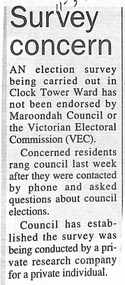
``Newspaper clipping from the "Post", 11-3-97, P5, Survey concernAn election survey carried out in Clock Tower Ward has not been endorsed by Maroondah Council or the Victorian Electoral Commission (VCE). Council has established the survey was being conducted by a private research company for a private individual.` -
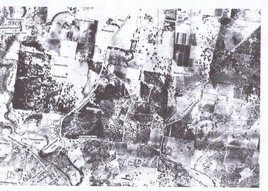
 Greensborough Historical Society
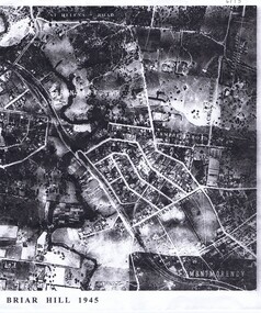
Aerial Photograph, Briar Hill 1945, 1945_
Aerial survey photograph of Briar Hill area produced in 19452 photocopies of aerial surveysbriar hill -
 City of Moorabbin Historical Society (Operating the Box Cottage Museum)
Photograph - Map of Dendy's Special Survey, 1852 Map of Henry Dendy's Special Survey of 1841, 19th Century
A Map drawn in 1852 that shows the 5,120 acres that formed Dendy's Special Survey of 1841. In 1840 Henry Dendy, a farmer in Surrey, England acquired a "Special Survey" from the Commissioners for Land and Emigration which gave Dendy the right to choose land in Port Phillip for the "bargain basement" price of only £1 per acre for 5120 acres, (an area of 8 square miles). The Special Survey also included the right to "the shipment of a worker for every £20 spent on land, whose free passage was paid by the Crown, equalling a total of 100 workers ". Accordingly Dendy sold his English holdings and paid the required £5120 and arrived in Melbourne in February 1841. However by this time land in the new colony was selling for £5 - £40 per acre. Because Henry Dendy possessed the order from the Colonial Office in London he was able to successfully oppose Governor LaTrobe's attempts to alter the price of the land. Dendy appointed Jonathan Were, (an entrepreneur, who had arrived in 1839), as his Manager and who later became a partner. Together, Dendy and Were decided on an area 5 miles south from Melbourne, bounded by North Road, East Boundary Road, South Road and to the west by Port Phillip Bay. Were and Dendy pitched their tents in the area now known as ' Park St, Brighton' and sank a well near the corner of 'St Andrew's St and Wells St'. By 1845 J.B Were and Company had bought almost half of Dendy's land and Were built himself "Moorabbin House" in Were St Brighton made from stone, quarried from local cliffs. It was still standing in 1924. Legend records Moorabbin is named after the Aboriginal word for ' Mother's Milk ' The soil is very fertile and well supplied with water especially in the area called 'East Brighton' - now known as Bentleigh and East Bentleigh - By 1850 the area had developed with numerous market gardens, dairy farms, fruit gardens and vineyards supplying food for the growing population of Melbourne.This Map shows the birth of the Brighton and Moorabbin area. On 18th January1859 Brighton was proclaimed a Municipality and a Borough by October 1863. Meanwhile, following a Petition, the area of East and South Brighton, incorporating Mordialloc, Cheltenham, Mentone, Sandringham and Oakleigh separated from Brighton to form the Moorabbin District Roads Board becoming the first Local Government Authority. Col. William Mair was elected as the first Chairman of the Moorabbin Roads Board. Moorabbin Shire 1871 developed further and was declared a City in1934. The City of Moorabbin was the largest Municipality in Melbourne before the Amalgamation of Councils in 1994 when it was divided in the south to City of Kingston and in the north to City of Glen Eira A Photo-lithographed 1852 Map showing the 5,120 acres that formed Dendy's Special Survey of 1841. Henry Dendy & Jonathan Were chose an area 5 miles south from Melbourne, bounded by North Road, East Boundary Road, South Road and to the west by Port Phillip Bay. Moorabbin County of Bourke / Photo-Lithographed at the department of Lands and Survey. /Melbourne. / Price 1/- brighton, moorabbin, bentleigh, cheltenham, dendy henry, bent thomas, were jonathan, special survey -
Whitehorse Historical Society Inc.
Map, M.M.B.W, c1962
Melbourne Metropolitan Area Base Map series sheet 235, covering part, Mitcham, Nunawading and Ringwood areas.Melbourne Metropolitan Area Base Map series sheet 235, covering part, Mitcham, Nunawading and Ringwood areas. Prepared by Department of Lands and Survey and Melbourne and Metropolitan Board of Works from State aerial Survey, June 1957 and Cadastral Survey information, August 1960. Scale 1:4,800.Melbourne Metropolitan Area Base Map series sheet 235, covering part, Mitcham, Nunawading and Ringwood areas. maps, mitcham, nunawading, ringwood, melbourne and metropolitan board of works, victoria. department of lands and survey -
 Bendigo Historical Society Inc.
Map - STRUGNELL COLLECTION: HUSTLER'S LINE OF REEFS, BENDIGO, September 1913
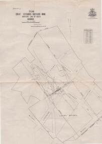
Map, Hustler's Line of Reefs, Great Extended Hustler's Mine Plan,Plate No X (10).Bulletin No 33 Signed H.A.Whitelaw Underground survey Office Bendigo September 1913 Drawing has a table showing depths of levelsUnderground Survey Office, Bendigo.map, bendigo, great extended hustler's mine -
 Bendigo Historical Society Inc.
Map - STRUGNELL COLLECTION: HUSTLER'S LINE OF REEFS, BENDIGO, September 1913
Map, Hustler's Line of Reefs, Comet Mine, Longitudinal Section.Plate No.XXV1 (26).Bulletin No 33 Signed H.A.Whitelaw Underground survey Office Bendigo September 1913 Drawing shows the vertical shaft descending to over 1692 feetUnderground Survey Office, Bendigo.map, bendigo, comet mine -
Whitehorse Historical Society Inc.
Document, Mitcham Repertory Group, 1972
Mitcham Repertory Group Survey .Mitcham Repertory Group. Survey of members, 1972.Mitcham Repertory Group Survey . mitcham repertory group, grant, max -
Glenelg Shire Council Cultural Collection
Photograph - Photograph - aerial view of the train track between Heywood and Rennick, 03/05/1952
Black and white aerial photographs (aerial survey record print) of the railway line between Heywood and Rennick (S.A. border) Taken for Victorian Railways, May 1952. Some photos have annotations later added to the front of the image in penVictorian Railways aerial survey record print of the railway line between Heywood and Rennick (S.A. border) Black and white, white vertical strip on imageFront: Annotations in red ink added at a later date Back: 'Heywood - Rennick 21577 - 19840 279m 41c ' - all black ink. White sticker, black print 'Rennick' Purple VR aerial survey stamp. '3 May 1952' - black stampvictorian railways, travel, train, transport -
 Bendigo Historical Society Inc.
Map - STRUGNELL COLLECTION: HUSTLER'S LINE OF REEFS, BENDIGO
Map, Hustler's Line of Reefs, Comet Mine, Plan, Plate No. XX111 (23).Lightning Hill Anticline at Surface, United Hustler's & Redan Co., Hustler's Reef Co..Bulletin No 33 Signed H.A.Whitelaw Underground survey Office Bendigo September 1913Underground Survey Office, Bendigo. -
Whitehorse Historical Society Inc.
Book, Archaeological Survey, 1/05/2000 12:00:00 AM
An archaeological survey at Deep Creek and Loughnan Roads, Mitcham Victoria.An archaeological survey at Deep Creek and Loughnan Roads, Mitcham Victoria. Project No 1660. Survey prepared for Vicroads as part of the preparation for the Eastern Freeway.An archaeological survey at Deep Creek and Loughnan Roads, Mitcham Victoria. historic buildings, archaeology, eastern freeway extension, deep creek road, mitcham, loughnan road, ringwood, vicroads -
 Forests Commission Retired Personnel Association (FCRPA)
Gunter's Chain
... Surveying ...Before metrication was introduced into Australia in the 1970s land was measured in chains and links. Many old parish plans show length measurements in chains and links. Area was shown in acres, roods and perches. Gunter's chain was used for measuring distance in surveying. It was designed and introduced in 1620 by English clergyman and mathematician Edmund Gunter (1581–1626). Gunter developed the measuring chain of 100 links. The chain and the link, became statutory measures in England and subsequently the British Empire. After metrication units of length were measured in meters and area in hectares. The chain was later superseded by steel ribbon tape.The 66-foot long (1 chain) Gunter's Chain was a fundamental instrument for land surveying. It is divided into 100 links (each 7.92 inches long) which are marked off into groups of 10 by brass tags with 'fingers' to indicate 10, 20, 30, 40 and 50 links from the hand grips, thus simplifying intermediate measurements. Each end of the chain is fitted with a brass hand grip. It was heavy and sturdy enough to be dragged through the bush and over rough terrain on surveying transects. Giving rise to the common forestry term "chainman" for the person tasked with dragging it. 1 chain = 100 links = 22 yards = 66 feet = 792 inches = 4 rods, poles or perches. 10 chains = 1 furlong 80 chains = 1 mile 1 acre = 10 square chains = 4 roods = 160 square rods, poles or perches.forest measurement, surveying, forests commission victoria (fcv) -
Whitehorse Historical Society Inc.
Map, Plan of special survey selected by H. Elgar Esq, 1841
Photocopy of plan and listing of corner stakes.Photocopy of plan and listing of corner stakes. Note on verso: Plan of special survey selected by H. Elgar Esq in the Parishes of Boroondara and Nunawading, County of Bourke. Surveyed by T.H. Nott (?Sydney) 31 May 1841. Boroondara Special Survey B.17, with attached descriptive note by T. H. Nott.Photocopy of plan and listing of corner stakes. maps, parish of boroondara, parish of nunawading, elgar, h, nott, t.h. -
 Greensborough Historical Society
Aerial Photograph, St Helena 1945, 1945_
Aerial survey photograph of St. Helena Road area of Greensborough3 copies, various enlargements of aerial surveygreensborough, st helena, st helena road -
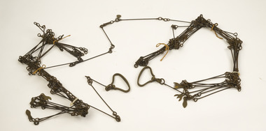
![Survey metal tape on reel with leather bag. 10 yards in length, the metal chain is subdivided every 10 links [2.2 yards].](/media/collectors/4f729f7e97f83e03086018d1/items/5f87f8fd13cca91a6c1db65a/item-media/615a8287eb51660bb8dc9e31/item-fit-380x285.jpg) Queenscliffe Maritime Museum
Queenscliffe Maritime MuseumInstrument - Survey tape on metal reel in leather bag with other articles
A surveyors chain is actually a thin steel band on a reel and is used for accurate measurements. This 110 yard [101m] chain is subdivided every 10 links [2.2 yards or 2m]Items belonged to J P Larkin Government marine surveyor who worked on surveys up to 1938. He worked in Port Phillip and Queenscliff related surveys [e.g. Western channel, Queenscliff channel].Survey tape on metal reel in leather bag with other articles: plumb bobs, number pegs, drawing instruments in box and steel punchesMade by A.E. Parsons surveying instruments, 215 Queen Street Melbournesurveying equipment, j p larkin -
 Bendigo Historical Society Inc.
Map - COMET MINE - TRANSVERSE SECTION COMET MINE
Transverse section of the Comet Mine on the Hustler's Line of Reef Bulletin No 33, Plate No XXV signed by H. A. Whitdon, Underground Survey Office Bendigo September,1913. Map shows depth of the different levels, the type of stone and shaft about 2020 deep. A number of smaller drawings on the side. Reference explaining the different types of stone, etc. Geological Survey of Victoriamining, hustler's line of reefs, transverse section of comet mine bulletin no 33 plate no xxv, lightning hill line of reef -
 Bendigo Historical Society Inc.
Map - COMET MINE - PLAN OF COMET MINE
Plan of the Comet Mine on the Hustler's Line of Reefs Bulletin No 33, Plate No XXIII. Map shows depths, Lightning Hill Anticline, Hustler's Anticline and approximate Lease Boundary. Signed by H. S. Whitelaw, Underground Survey Office Bendigo, September 1913. United Hustler's & Redan Co and Hustler's Reef Co also named on map. Geological Survey of Victoriamining, hustler's line of reefs, comet line plan belletin no 33 plate no xxiii, lightning hill anticline, hustler's anticline, united hustler's & redan co, hustler's reef co, h s whitelaw