Showing 1555 items matching "aerial photograph"
-
 Inverloch Historical Society
000146 - Photograph - Aerial Photograph - R Young
... 000146 - Photograph - Aerial Photograph - R Young...) Inverloch gippsland 000146 - Photograph - Aerial Photograph - R ... -
 Whitehorse Historical Society Inc.
Map, Aerial photograph, c1950
... Aerial photograph... Mitcham melbourne vermont south burwood east aerial photographs ...Arial photo of Vermont South and Burwood East, Middleborough Road, Burwood Highway, Springvale Road, Highbury Road and environs.Aerial photo of Vermont South and Burwood East, Middleborough Road, Burwood Highway, Springvale Road, Highbury Road and environs.Arial photo of Vermont South and Burwood East, Middleborough Road, Burwood Highway, Springvale Road, Highbury Road and environs.vermont south, burwood east, aerial photographs -
 Inverloch Historical Society
001247 - Photograph - circa 1960's - Aerial Photograph - Inverloch from North East (looking South West) - from L Bailey
... 001247 - Photograph - circa 1960's - Aerial Photograph...) Inverloch gippsland 001247 - Photograph - circa 1960's - Aerial ... -
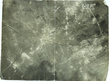 Ringwood RSL Sub-Branch
Photograph WW1, Aerial photograph
... Aerial photograph... melbourne 12 L.B. 1592 51B.U.23. 15.10.17.11 WW1 front line Aerial ...WW1 front line12 L.B. 1592 51B.U.23. 15.10.17.11 -
 Stawell Historical Society Inc
Photograph, Aerial Photograph of town of Stawell Sept 1983
... Aerial Photograph of town of Stawell Sept 1983... taken facing North East and Mine site at rear of photo Aerial ...Photo taken facing North East and Mine site at rear of photo6 Stawell, Victoria Sept 1983panorama, streetscape -
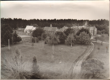 Ballarat and Queen's Anglican Grammar School
b&w Photograph, Aerial photograph of School Buildings
... Aerial photograph of School Buildings... corner of Ballarat Grammar property Aerial photograph of School ...Aerial view of School buildings showing chapel LHS and foreground on south east corner of Ballarat Grammar propertyVerso - N. L. HARVEY (Press Photo Service) A.M.P. Chambers Lydiard St. N. 2993 pencilled in on versoballarat-grammar, buildings, school, education, wendouree, ballarat, chapel -
 Ithacan Historical Society
Photograph, Aerial photograph - Platrithia, Ithaca, c1970s
... Aerial photograph - Platrithia, Ithaca...The photograph is an aerial view of the village... Street Melbourne melbourne The photograph is an aerial view ...The photograph is an aerial view of the village of Platrithia in northern Ithaca, overlooking Afales Bay. The Taxiarchi Church is located at the top of the hill, around which the village is located.A discoloured landscape of an aerial view of Aphales Bay and Platrithia with the church of Taxiarches and the road which leads to Marmaka located on the other side of the mountain.aphales, villages -
Stawell Historical Society Inc
Photograph, B/W Aerial Photograph of Pleasant Creek Training Centre & Stawell Woolen Mills C 1960's, 1960's
... B/W Aerial Photograph of Pleasant Creek Training Centre... backing board. B/W Aerial Photograph of Pleasant Creek Training ...A3 Sized Aerial Photo on blue backing board.education, manufacturing -
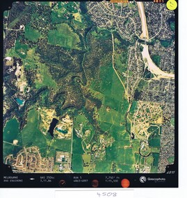 Greensborough Historical Society
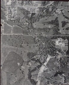
Aerial photograph, Qascophoto, Greensborough, 03/11/1986
... Aerial photograph...Colour aerial photograph QAS 2504c run 5 3/11/86 1:15,500... road Colour aerial photograph QAS 2504c run 5 3/11/86 1:15,500 ...Aerial survey of Plenty Gorge Park area, including Greensborough by-pass construction and Metropolitan Ring Road reservation.An historical view of developing GreensboroughColour aerial photograph QAS 2504c run 5 3/11/86 1:15,500 by Qascophotoplenty gorge park, greensborough bypass, metropolitan ring road -
Stawell Historical Society Inc
Photograph - Aerial Photograph, Norwellan / AUNDE
... Aerial Photograph...Early Colour Aerial Photograph showing complete land... Colour Aerial Photograph showing complete land and infrastructure ...Textile Mill infrastructure when Norwellan North Western Woolen Mills became Norwellan Textiles then AUNDEEarly Colour Aerial Photograph showing complete land and infrastructure. Plastic frame imitating brown marble.industry -
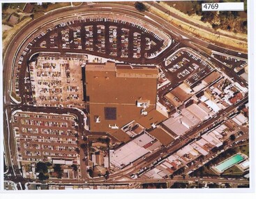 Greensborough Historical Society
Aerial Photograph, Greensborough Plaza Aerial View, 1979c
... Aerial Photograph...Early aerial photograph of Greensborough Plaza, 1970.... Plenty Lower Plenty melbourne Early aerial photograph ...Early aerial photograph of Greensborough Plaza, 1970.Colour photocopy of aerial survey, laminatedgreensborough plaza -
 Kew Historical Society Inc
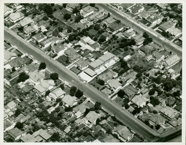
Photograph - Aerial photograph of the intersection of Derby and Earl Streets, Kew, c.1970
... Aerial photograph of the intersection of Derby and Earl...Black and white aerial photograph of the intersection... Black and white aerial photograph of the intersection of Derby ...Black and white aerial photograph of the intersection of Derby and Earl Streets in Kew. The photo is presumed to date from c.1970.Nilearl street -- kew (vic.), derby street -- kew (vic.) -
 Greensborough Historical Society
Aerial Photograph, Banyule Road / Lower Plenty Road, 1972c
... Aerial Photograph...Aerial survey photograph, black and white... Aerial survey photograph, black and white Banyule Road / Lower ...Viewbank, Rosanna and Lower Plenty area, showing Lower Plenty Road and Banyule RoadAerial survey photograph, black and whiteviewbank -
 Eltham District Historical Society Inc
Photograph - Aerial Photograph, Intersection of Main Road and Bridge Street, c.1995
... Aerial Photograph...Digital scan detail section of much larger aerial... scan detail section of much larger aerial photograph ...View of Main Road from Henry Street to Brougham Street across to the Diamond Creek showing the Eltham Shire Offices (demolished 1996), the Eltham Library (opened 1994)aerial photo, alistair knox park, bridge street, brougham street, central park, diamond creek (creek), eltham, eltham community centre, eltham courthouse, eltham justice precinct, eltham living and learning, franklin street, henry street, local history centre, main road -
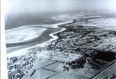
 Orbost & District Historical Society
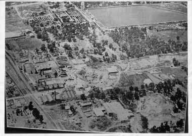
aerial photograph, 1970's
... aerial photograph...A large black and white aerial photograph of Orbost Railway... orbost A large black and white aerial photograph of Orbost ...This photograph was taken prior to the closure of the Orbost -Bairnsdale freight line in 1987.The Orbost-Bairnsdale railway initially played a crucial role in developing agricultural industries in Gippsland as well as tourism. It opened in 1916 and operated until 1987, principally carrying timber and farming produce. In the early days of the railway's operation dedicated passenger trains ran but these ceased by the 1930s. The line was completely closed to freightage in 1987.The track infrastructure was dismantled in 1994 and has been redeveloped as the East Gippsland Rail Trail.A large black and white aerial photograph of Orbost Railway Station in the foreground and the Orbost township in the background. It has been pasted onto a piece of Masonite. railway photography orbost, railway photography orbost -
 Whitehorse Historical Society Inc.
Photograph - Aerial Photograph, Mitcham Reservoir
... Aerial Photograph...Black and white aerial photograph of Mitcham showing...) in the foreground. Mitcham Reservoir Photograph Aerial Photograph ...Most of the area is now Thornton Crescent, Mitcham, a factory area. When erecting the present 'buildings', which are all single level, certain strategies were employed to ensure safety.Black and white aerial photograph of Mitcham showing the reservoir, Australian Tesselated Tiles with the clay pit at the rear, and Monarch Tiles (1914-16) in the foreground.mitcham reservoir, australian tesselated tile co. pty ltd, monarch terra cotta pty ltd -
Glenelg Shire Council Cultural Collection
Photograph - Photograph - Aerial photograph of coastline around Portland Victoria, c. 1954
... Photograph - Aerial photograph of coastline around Portland...Black and white aerial photograph of coastline around..., white border Black and white aerial photograph of coastline ...Black and white aerial photograph of coastline around Portland. Black border, bottom edge, section of larger photo, approximately 50%, only land visible.Front: 'PORTLA' -printed, white border -
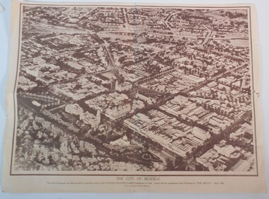 Bendigo Historical Society Inc.
Document - BAGGALEY COLLECTION: LARGE AERIAL PHOTOGRAPH POSTER OF BENDIGO APRIL 1936
... BAGGALEY COLLECTION: LARGE AERIAL PHOTOGRAPH POSTER OF...Sepia print of an aerial photograph of the centre...: LARGE AERIAL PHOTOGRAPH POSTER OF BENDIGO APRIL 1936 ...Sepia print of an aerial photograph of the centre of Bendigo taken specially for the occasion of the United Country Party conference of 1936 Issued with the compliments of 'the Argus' April 1936Wilson and Mackinnon Printers, Melbourne -
Glenelg Shire Council Cultural Collection
Photograph - Photograph - Aerial photograph of coastline around Portland, Victoria, c. 1954
... Photograph - Aerial photograph of coastline around Portland...Black and white aerial photograph of coastline around... Black and white aerial photograph of coastline around Portland ...Black and white aerial photograph of coastline around Portland. Black border, scale all sides, 5 rows of 3 't' at regular intervals. Mostly landFront: '607 - 52 ' - handwritten, white, border 'RUN 7 ' 'PORTLAND', printed, white, border -
Bendigo Historical Society Inc.
Photograph - AERIAL PHOTOGRAPH OF THE CITY OF BENDIGO, April 1936
... AERIAL PHOTOGRAPH OF THE CITY OF BENDIGO...Photograph, Aerial Photograph of The City of Bendigo..., Melbourne. Photograph, Aerial Photograph of The City of Bendigo ...Photograph, Aerial Photograph of The City of Bendigo,was taken specially to mark the occasion of the United Country Party Conference of 1936. Issued with the compliments of the Proprietors of 'The Argus', April 1936Wilson and Mackinnon, Printers, Melbourne.photograph, streetscape, bendigo -
Glenelg Shire Council Cultural Collection
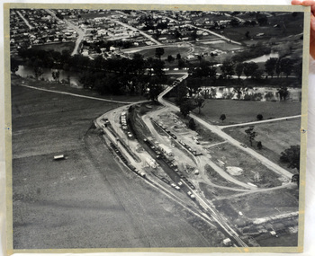
Photograph - Photograph - Aerial photograph of Portland harbour taken from the north east, 1967
... Photograph - Aerial photograph of Portland harbour taken...Black and white unframed aerial photograph of Portland... in existence) Black and white unframed aerial photograph of Portland ...Front: (no inscriptions) Back: Portland Harbour 1967/ No 6 berth under construction (ocean pier and railway pier still in existence)port of portland archives -
Glenelg Shire Council Cultural Collection
Photograph - Photograph - Aerial photograph of coastline, Portland Victoria, c. 1954
... Photograph - Aerial photograph of coastline, Portland...Black and white aerial photograph of coastline around... Black and white aerial photograph of coastline around Portland ...Black and white aerial photograph of coastline around Portland. Black border, scale all sides, 5 rows of 3 't' at regular intervals. 80/20 ocean to landFront: '784 - 147 ' - handwritten, white, border 'RUN 7 A PORTLAND', printed, white, border -
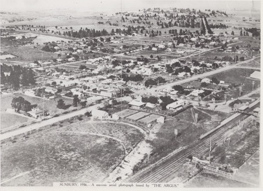 Sunbury Family History and Heritage Society Inc.
Photograph, 1936
... A black and white aerial photograph with a cream border...SUNBURY 1936 - A SOUVENIR AERIAL PHOTOGRAPH ISSUED... of Melbourne. Aerial photographs SUNBURY 1936 - A SOUVENIR AERIAL ...The aerial view of Sunbury was featured in The Argus newspaper in 1936 in recognition of 100 years of European settlement of the area. It shows the extent of the township in 1936 which extended from the railway line in the west to the Jackson Creek in the east and the Sunbury Asylum in the south and northwards towards Macedon Street. The photograph was taken when Sunbury was a country settlement 25 miles ( 37 kms) from Melbourne. Since the 1980s the area grown rapidly and is now an outer suburb of Melbourne.A black and white aerial photograph with a cream border of the Sunbury township. SUNBURY 1936 - A SOUVENIR AERIAL PHOTOGRAPH ISSUED BY THE ARGUS.aerial photographs -
Glenelg Shire Council Cultural Collection
Photograph - Photograph - Aerial photograph of an area of Portland, Victoria, 1955
... Photograph - Aerial photograph of an area of Portland...A black and white aerial photograph taken from the N.W.../74 A black and white aerial photograph taken from the N.W ...Port of Portland CollectionA black and white aerial photograph taken from the N.W. of T.B.& S. abattoir, red brick wool store, petroleum installations, north/central Portland residential areas and Portland Harbour.Front: NOV 1955 'AIRSPY PHOTO' ref NO 2/b/74port of portland -
Tatura Irrigation & Wartime Camps Museum
Aerial Photograph, 1959
... Aerial Photograph... with glass front. Aerial Photograph ...Enlarged aerial photo of Tatura township taken by J. Underwood (Kyabram) in January 1959. Photo framed with glass front.Tatura Jan 1959. Arthur J. Underwood Photographer Tel. Kyabram 629tatura, aerial photography, photography, photograph, slides, film -
 Bayside Gallery - Bayside City Council Art & Heritage Collection
Photograph, Department of Crown Lands and Survey, Victoria, Brighton, Brighton East and Bentleigh, c. 1965-71
... Aerial photograph.... This aerial photograph shows parts of Brighton, Brighton East...Black and white photograph. An aerial photograph showing... and Survey Aerial photograph Bayside Port Phillip Bay Map ...The Department of Crown Lands and Survey (1857-1983) was responsible for the administration of survey and mapping and the sale, occupation and management of crown land throughout its existence. This aerial photograph shows parts of Brighton, Brighton East and Bentleigh and was taken circa 1965-71.brighton, department of crown lands and survey, aerial photograph, bayside, port phillip bay, map, cartographic material, bentleigh, brighton east, dendy park, dendy street, centre road, nepean highway, south road, football -
 Bayside Gallery - Bayside City Council Art & Heritage Collection
Photograph, Department of Crown Lands and Survey, Victoria, Brighton, Brighton East and Bentleigh, c. 1965-71
... Aerial photograph.... This aerial photograph shows parts of Brighton and Brighton East...Black and white photograph. An aerial photograph showing... Aerial photograph Bayside Port Phillip Bay Map cartographic ...The Department of Crown Lands and Survey (1857-1983) was responsible for the administration of survey and mapping and the sale, occupation and management of crown land throughout its existence. This aerial photograph shows parts of Brighton and Brighton East and was taken circa 1965-71.brighton, department of crown lands and survey, aerial photograph, bayside, port phillip bay, map, cartographic material, brighton east, dendy park, dendy street, centre road, nepean highway, south road, brighton golf course, golf -
Glenelg Shire Council Cultural Collection
Photograph - Photograph - Aerial photograph of coastline around Portland, Victoria, c. 1954
... Photograph - Aerial photograph of coastline around Portland...Black and white aerial photograph of coastline around... Black and white aerial photograph of coastline around Portland ...Black and white aerial photograph of coastline around Portland. Black border, scale all sides, 5 rows of 3 't' at regular intervals. Bottom 20% ocean, rest land, separated by beach.Front: '607 - 88' - handwritten, white, border 'RUN - 6 PORTLAND', printed, white, border -
 Ballarat Heritage Services
Aerial digital photograph, L.J. Gervasoni, Mouth of the Yarra River and Westgate on approach to Melbourne's Tullamarine Airport, 2016
... Aerial digital photograph...aerial photograph... gate bridge aerial photograph Digital aerial image of Melbourne ...hoto taken from flight in to Melbourne International airport.Digital aerial image of Melbourne, Victoria.aerial, landscape, cityscape, mouth, yarra river, west gate bridge, aerial photograph -
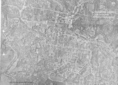 Eltham District Historical Society Inc
Work on paper (Sub-Item) - Aerial Photograph, Diamond Creek from Yarra River to Wattletree Road, Eltham
... Aerial Photograph...Black and white aerial photograph witrh key features around... melbourne Black and white aerial photograph witrh key features ...Black and white aerial photograph witrh key features around the central place of Eltham township marked inluding Yarra River, Main Road, Bridge Street and Ryans Road, Eltham North land development, real estate, aerial view, eltham, eltham north