Showing 170 items
matching contours
-
 Kiewa Valley Historical Society
Plans - Kiewa Works Area and Environs
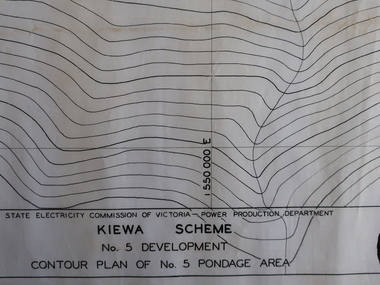
State Electricity Commission of Victoria constructed the Kiewa Hydro Electric Scheme from the late 1940s to 1961. These plans were used during the construction.Plans and Maps were used during the construction of the Kiewa Hydro Electric SchemeTransparent with blue tinge plans/maps created by the SECV during the construction of the Kiewa Hydro Electric Scheme. 1. Kiewa Scheme No 5 Development Contour Plan of No 5 Pondage Area 2. Mt Beauty Township 3. Kiewa Scheme No 1 Development - McKay Creek Area, Construction Layout 4. Kiewa Works and Environs 5. North Eastern Victoria and Adjoining Snowy Mountains Regionsecv, kiewa hydro electric scheme plans -
 Kiewa Valley Historical Society
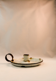
Candle Holder x2, circa early 1900
Historically this item was before electricity lighting was available. There is no protection around the candle to prevent wind or air movement from extinguishing the candle flame therefore this means of night illumination was used within a house environment. It could be easily moved from room to room but would have insignificant "candle power" to lighten more than a few metres around it. This item was before kerosene lamps, gas lighting and electric/battery lamps This candle holder would have been used within the homes of Kiewa residences to illuminate the way from room to room where there were no other forms of lighting available. As it is relatively light in weight and with a finger/s grip it is highly portable and was in time replaced by battery powered torches. It was used in a period where home, or local made candles were a necessity of living. This Item was used before battery powered torches were invented. Although candles are still used in the late 20th and after, their fundamental use has changed and they function more as a mood enhancement item or as a back up for an electrical power failure and the alternative battery powered torch also runs out of power.1. This small basin shaped candle holder is formed of metal and sealed with a pale grey enamel skin. It has a black painted edge and finger holder. It has a raised vertical spout for the securing of the candle. The bottom of the basin is contoured from the candle base to the outer edge to allow for melted candle wax to be safely held within the basin. 2. As above. The handle is rusty but otherwise in good condition. candle-holder, portable light enamel household goods -
 Bendigo Historical Society Inc.
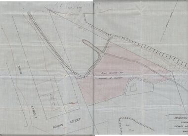
Plan - MCCOLL, RANKIN AND STANISTREET COLLECTION: PLAN OF MONUMENT HILL BATTERY
Pale blue waxed paper plan. Written on back of plan ' Monument Hill Battery site, area desired by Bendigo Mines (Nell Gwynne) for disposal of mullock. Plan shows Ophir Street, Rowan Street, Written on bottom RH corner 'Bendigo Mines Ltd., surface plan, vicinity Nell Gwynne Shaft, Scale 1" = 40' Magnetic north marked, sand dumps and contour lines.bendigo, business, mccoll, rankin & stanistreet -
 Bendigo Historical Society Inc.
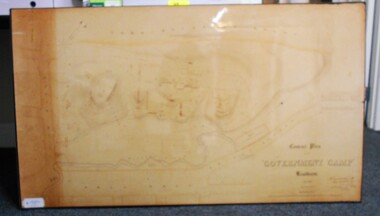
Map - CONTOUR PLAN OF THE GOVERNMENT CAMP SANDHURST 1854, 1994
Contour map (copy) of the Government Camp Sandhurst, 1854. Map is mounted on coreflute and laminated. Written in bottom righthand corner 'Contour Plan of the Government Camp, Sandhurst. Dec 1854. Signed by Richard Larritt, Assistant Surveyor, 11th December 1854.' Shown on map: Pall Mall, Bendigo Creek, Commissioner's Gully, View Place (now View Street), Post Office, Bank of Victoria, District Surgeon, Sandhurst Fire Brigade, Police Hospital, Flagstaff, Gold Office, License Shed, Military Barracks, Stables, Commissioner's Buildings, Police Office. Old Cemetery, Garden. Reference on righthand side: 'Stone or brick buildings are tinted in crimson. Wooden buildings tinted in Indian Ink. Tents and other temporary structures tinted in Burnt Sienna.' Scale of Chains, on bottom of map. Sticker on bottom left hand corner and back of map ' Presented by Survey and Mapping, Victoria, 7th Octber, 1994'.map, bendigo, government camp, pall mall, bendigo creek, commissioner's gully, view place (now view street), post office, bank of victoria, district surgeon, sandhurst fire brigade, police hospital, flagstaff, gold office, license shed, military barracks, stables, commissioner's buildings, police office. old cemetery, garden. , survey and mapping victoria. sandhurst, bendigo. -
 Dandenong/Cranbourne RSL Sub Branch
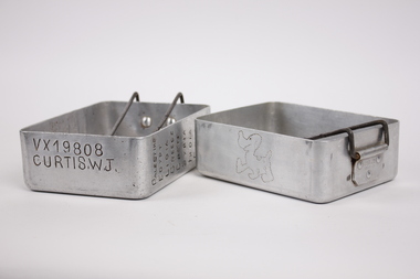
Functional object - Nested Mess Tins, 1939
This kit belonged to VX19808 William James Curtis. WWII sgnigificance.2 x metal nested mess tins with swivel handlesHand inscribed with VX19808 Curtis W.J. Palestine, Egypt, Libia, Greece, Crete, Syria, India and Ceylon. Also inscribed with Dunera, Arayabank, Heroward, Costa Rica, Hero, Kimberley, Nurmahal, Smaller mess tin inscribed with VX19808 Curtis. W. J. Also engraved on side contour of a dog. -
 Greensborough Historical Society
Map, Melbourne and Metropolitan Board of Works. Survey Division, MMBW, Yarra 2500 / 12.22. Watsonia North, 1978_03
Melbourne and Metropolitan Board of Works. Yarra 2500 [base map]. 12-22, Parishes of Keelbundora 2856, Municipalities of Whittlesea 239 and Diamond Valley 257. Shows street names, easement sizes, lot numbers, lodged plan numbers, names of prominent features, contour values, creek or river names. Watsonia Railway Station and environs. Prominent streets: Edmund Rice Parade and Macorna Street. Includes Christian Brothers Edmund Rice College and Janefield Special School sites and "proposed future freeway" (now Metropolitan Ring Road).MMBW Map in 1:2500 [scale] series. Cream parchment with green tape reinforcing on edges and punched holes on left edge.mmbw, melbourne and metropolitan board of works, shire of diamond valley, watsonia - maps, bundoora - maps -
 Geoffrey Kaye Museum of Anaesthetic History
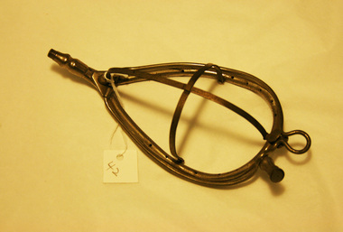
Equipment - Mask, Wire, Ether, 1910
Mask used for administering ether anaesthesia. This mask also has a carbon dioxide inlet tube. Carbon dioxide was found to promote deeper breather which assisted in attaining faster anaesthesia. The mask was designed by an American anaesthetist James Tayloe Gwathmey, (1863-1944). Gwathmey invented a range of anesthesia equipment. In 1904, he introduced this mask as one part of a resuscitation apparatus. Gwathmey modified an existing mask to more closely fit the contours of the face. The holes in the rim allow for oxygen to be delivered for resuscitation or for the delivery of a combination of oxygen and anaesthetic. Wire framed mask in tear shape. There is a hinged top bracket which allows for a piece of flannel or domette to secured to the mask, onto which the ether would be administered. There is an inlet tube near the hinged bracket to allow for the administration of CO2 or oxygen and the rim is pierced with holes.james tayloe gwathmey, ether, anaesthesia, anesthesiologist, carbon dioxide, oxygen -
 Williamstown High School
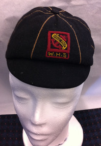
School cap 1936
Woollen cap worn by Williamstown High School boys in the 1930's. This cap was worn by Ron Granger in 1936. Cap is black wool with a green woollen lining to the peak.Fully lined in black cotton. The cap has yellow stitching following contours ending at a black wool covered button. The logo is a red square containing a red anchor with yellow banner across the centre with 'Hold Fast'. 'W.H.S' under sqare in yellow.williamstown high school, school uniform, cap, 1936 -
 University of Melbourne, Burnley Campus Archives
Plan - Coloured plan, Plan of Burnley Gardens, 1929?
Layout of gardens, farm buildings, orchard, etc. overlaid on part of Lands Department map. See paper catalogue for full descriptionPart of larger plan (Lands Department Parish Plan). Partly hand-drawn. Area bounded by Yarra River, Swan St, Glen Iris railway line. Shows Burnley Gardens layout, handwritten amendments and explanation of existing and proposed structures including: Pavilion, sketch of unbuilt Administrative Building, poultry yard, contours of old orchard, sketch for Plant Research Institute, ditch, silo, milking shed, laying pens. See aboveburnley gardens, pavilion, burnley school of horticulture, farm buildings, poultry -
Bendigo Historical Society Inc.
Document - Hustler Mine Sites
One page photocopy: section of a mining map, showing contour lines and mine locations of the following mines: Hustlers Royal Reserve 1775 ft Park Shaft Royal Hustlers Shaft 1150 ft Imperial Hustlers Shaft Hustlers Extended Hustler Trib Shaft 1970 ft. Great Extended Hustlers Great Extended Streets on the map: Barkly Street, Drought Street, Rosalind Street and Hope Street. -
 Bendigo Military Museum
Map - Australian Topographical Survey NAGAMBIE SW Sheet, 1 inch:1 Mile, NW portion Plane Table Field sheet 1921, Australian Survey Corps, 1921
This is a coloured reproduction print of an original Plane Table compilation map sheet of Nagambie area 1inch to 1 Mile scale compiled by Sgt Jack Cullen Australian Survey Corps 30 September 1921. Jack was one of the foundation members of the Australian Survey Corps. Of particular interest is the fact that this is a heighted compilation with contouring (required for Military use) as many early maps were purely planimetric. A table on the right hand side details the number of days that it took to produce the compilation. The reverse side of this print is a copy of the Tallarook plane table South East field sheet.Reprinted coloured Image of Australian Topographical Survey NAGAMBIE SW Sheet,1 inch:1 Mile, NW portion hand drawn Plane Table Field sheet. Includes an itemized summary of work, signed by Sgt J Cullen Australian Survey Corps September1921.royal australian survey corps, rasvy, fortuna, army survey regiment, army svy regt, asr -
 Nillumbik Shire Council
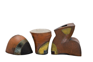
Sculpture: Jane ANNOIS, Jane Annois, Evolution, 2006
Jane Annois had a long involvement with Potters Cottage in Warrandyte, where she taught for many years. Potters Cottage was established in the late 1950s in Warrandyte as an artist co-operative. Founding members included Reg Preston, Phyl Dunn, Gus McLaren, Artur Halpern, Sylvia Halpern and Elsa Ardern. These talented artists had the ingenuity and foresight to create a teaching studio, gallery shop and restaurant to experiment, make, promote and sell predominantly domestic wares of the time. These activities helped financially sustain each member’s individual creative practice. Potters Cottage was influential in the development of contemporary ceramics, building and developing practices that experimented with traditional ceramic processes, raw materials and locally sourced clay. The group mentored and nurtured many interested in the art of ceramics, producing alumni and teachers such as Peter Laycock, John Dermer, Greg Daly and Jane Annois. Jane Annois is a ceramic artist who has lived and worked locally in Warrandyte for many years. She focuses primarily on exploring the art of Japanese raku, adapting the technique to develop the typical characteristics of crackle glazes and lustres, with contrasting areas of black. Jane also applies a fine slip called terrasigillata which gives soft, warm ochre colours. This technique was once used by the Greeks over 2000 years ago to seal and decorate their pots. She is also strongly onfluenced by the French potters, particularly in the style of terre vernissee, a decorative form of terracotta tableware. Three piece stoneware and raku fired ceramic sculpture. The first piece is a hollow, dome shaped object. It is orange (terracotta slip) in colour with a copper metallic band and a black edge on one side with a small yellow glazed rounded triangle and metallic strip of colour on the otherside. The second piece is shaped like a traditional vase. It is orange (terracotta slip) in colour with white crackle on the inside. It has a yellow slip edge with a dark glazed square on one side and on the other side a black thick edge that mirrors the contour of this shape. The third piece is shaped loosley in the form of the letter 'z'. It compliments the second piece with a yellow slip edge and black glazed square to its lower left side and top right as well as on its' other side a black thick edge that mirrors the contour of this shape. This piece has a very small skewed square opening at its' top. All three pieces have elements of crazing and variations of colour and lustre, caused by the raku process. 2006.52.1VA has the artist name/signature 'J. Annois' inscriped small (with fine point ceramic tool?) on the front of the piece, bottom right; 2006.52.2VA has the artist name 'Jane'? inscribed (unlegible - with fine point ceramic tool?) underneath; 2006.52.3VA has the artist name/signature 'Jane Annois' inscriped (with fine point ceramic tool?) inside its hollow form. evolution, raku, stoneware, terrasigillata, terracotta, glazes, slip, terre vernissee -
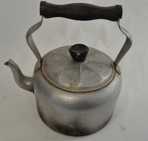 Kiewa Valley Historical Society
Kettle Aluminium, mid to late 1900's
This aluminium kettle was manufactured between 1940 to 1960's and replaced the heavier caste iron "open fire" stove ones (in doors or in the bush). A cast iron flat base between the open fires and the kettle was required. This kettle was used extensively with indoor open fire places. It was part of the evolution in "tea" making kettles. These were the only method of making hot beverages before introduction of electric kettles. For the Kiewa Valley the connection to the major electricity grid was post 1950's.This kettle is significant demonstrating the type of kitchen utensils required before electrical home connections became a reality. The aluminium structure of the kettle was an advancement over the heavier caste iron kettles. This type of kettle is still in use for bush and mountain hikers/climbers due to the light weight. This kettle was used by the Tawonga C.W.A. Branch. The C.W.A. motto "Honour our God, Loyalty to the throne, Service to the country, Through country women, For country women, By country women."This 99% aluminium hot plate kettle with lid (bakelite handle) is Australian made for flat stoves (cooking or room heating). It has a "tea style" spout and a bakelite hand grip(knob) on the top of the lid. The lid has nine ridges (for strength) radiating from the central hand grip. The two handle prongs are bop riveted onto the the body of the kettle. The bakelite hand grip has been fashioned to fit the natural contours of a clutching hand.On both sides of the aluminium handle "HOT PLATE WARE" and covering an oblique shaped triangle "99% PURE ALUMINIUM" and below that "MADE IN AUSTRALIA".Within the triangle "DURALIFE"cwa, homeware aluminium kitchen utensils, made in australia cook ware -
 Federation University Historical Collection
Photograph - Photograph and Documents, Anne Beggs Sunter, Latta/Downing Family, Mount Helen
The Federation University Mt Helen Campus was once the farm of John Latta and his wife Elizabeth Ann Dean. The couple married in 1867 and had three children at the time of John Latta's death (Elizabeth Ann b.1870; Mary b.1873; John b.1875). Elizabeth later married George Downing, and had another six children. The house was situated in the vicinity of the current Administration and Caro Conference Centre buildings, surrounded by an orchard, and a well under the current Albert Coates Building (Union Building). The land was purchased by the Ballarat School of Mines for their tertiary division from the Stapleton family.Various items relating to the Federation University Mount Helen Campus, and the early settlers on the land, the Latta Family. .1) Parish Plan, including E. Latta, M. Fiscalini, R. Wynne, R. Nixon, J.U. Smith, J. Davis .2) Part of a 1930s ordinance map showing Ballarat, Buninyong and Greenhill .3) Contour Map with the first two Mt Helen Campus buildings included. .4) Drawing a a proposed campus plan .5) Latta Family negativemount helen campus, latta family, greenhill, e. latta, m. fiscalini, r. wynne, r. nixon, j.u. smith, j. davis, parish plan, john latta, elizabeth latta, george downing, elezabeth downing, green hill, pontresina, abraham baxter, g. dean, market gardens, jim downing, bob thornton, j. hateley, martin fanning, toll keeper, anne beggs sunter -
 Bendigo Historical Society Inc.
Photograph - Historical Society Field Trip to the Springs at Sedgwick, Abt 2009
The Phil Wilkin Collection contains a series of 11 Items. The related items can be found by clicking on the reference link below. The following history of the Young family and their descendants who lived at the Springs is provided by Phil Wilkin. His Great Grandparents were Frances Young and August Wirth. Phil has also provided notes on the Wilkin Family and some history of the gold mining in Sedgwick. Frances Young's parents Joseph and Margaret Young owned the property called "The Old Place, Preston Vale or Wellington Flat" at Sedgwick near the Springs. Joseph Young owned and Managed the Standard Brewery which was located at Campbells Creek during the late 1800’s early 1900’s. Joseph and Margaret are buried in the Harcourt cemetery. In 1880 August Wirth lived at Mosquito Creek (Lake Eppalock, Victoria) when he married Frances Young. In 1902 they moved to part of Joseph Young's property. They milked cows and sold cattle for a living. One of their children Charles Wirth (Phil Wilkin's Grandfather) bought the land in 1935 after his parents had died. Charles Wirth was a councillor and also was president of the Shire of Strathfieldsaye. The "Old Place" was part of the property owned by members of the family. The old house at the Springs was burnt out by bushfire in January 1944 and much of the stonework was later vandalized by campers. The original Coliban Water Works were designed in 1863 by the Irish engineer Joseph Brady. The system included 70 kilometres of open water channels, aqueducts, syphons and tunnels to carry water (by gravity) from the Coliban River at Malmsbury, north to Castlemaine and Bendigo. Sedgwick is a locality in Central Victoria, Australia. It is located in the City of Greater Bendigo. Facilities include a public hall that opened in 1958 and CFA Rural fire station. It was named Upper Emu Creek until 1901 when it was renamed as Sedgwick after British geologist Adam Sedgwick.Twenty nine photos taken on a field trip by the Bendigo Historical Society to "The Springs" on the main Coliban water channel from Malmsbury to the Sandhurst Reservoir in Bendigo. The water race descends through a concrete chute, and continues sharply around the contour of the hills. Once it descended into a syphon across the gully. The are 182 photos in this series and can be found at 8683.1 to 8683.11. The series also includes photos of the surrounding farming land and the remains of an old house. There are also some notes on the pioneers of the district.history, bendigo, coliban water, joseph brady, irrigation, the springs, sedgwick -
 Bendigo Historical Society Inc.
Photograph - Historical Society Field Trip to the Springs at Sedgwick, Abt 2009
The Phil Wilkin Collection contains a series of 11 Items. The related items can be found by clicking on the reference link below. The following history of the Young family and their descendants who lived at the Springs is provided by Phil Wilkin. His Great Grandparents were Frances Young and August Wirth. Phil has also provided notes on the Wilkin Family and some history of the gold mining in Sedgwick. Frances Young's parents Joseph and Margaret Young owned the property called "The Old Place, Preston Vale or Wellington Flat" at Sedgwick near the Springs. Joseph Young owned and Managed the Standard Brewery which was located at Campbells Creek during the late 1800’s early 1900’s. Joseph and Margaret are buried in the Harcourt cemetery. In 1880 August Wirth lived at Mosquito Creek (Lake Eppalock, Victoria) when he married Frances Young. In 1902 they moved to part of Joseph Young's property. They milked cows and sold cattle for a living. One of their children Charles Wirth (Phil Wilkin's Grandfather) bought the land in 1935 after his parents had died. Charles Wirth was a councillor and also was president of the Shire of Strathfieldsaye. The "Old Place" was part of the property owned by members of the family. The old house at the Springs was burnt out by bushfire in January 1944 and much of the stonework was later vandalized by campers. The original Coliban Water Works were designed in 1863 by the Irish engineer Joseph Brady. The system included 70 kilometres of open water channels, aqueducts, syphons and tunnels to carry water (by gravity) from the Coliban River at Malmsbury, north to Castlemaine and Bendigo. Sedgwick is a locality in Central Victoria, Australia. It is located in the City of Greater Bendigo. Facilities include a public hall that opened in 1958 and CFA Rural fire station. It was named Upper Emu Creek until 1901 when it was renamed as Sedgwick after British geologist Adam Sedgwick.Twenty five photos taken on a field trip by the Bendigo Historical Society to "The Springs" on the main Coliban water channel from Malmsbury to the Sandhurst Reservoir in Bendigo. The water race descends through a concrete chute, and continues sharply around the contour of the hills. Once it descended into a syphon across the gully. The are 182 photos in this series and can be found at 8683.1 to 8683.11. The series also includes photos of the surrounding farming land and the remains of an old house. There are also some notes on the pioneers of the district.history, bendigo, coliban water, joseph brady, irrigation, the springs, sedgwick -
 Bendigo Historical Society Inc.
Photograph - Historical Society Field Trip to the Springs at Sedgwick, Abt 2009
The Phil Wilkin Collection contains a series of 11 Items. The related items can be found by clicking on the reference link below. The following history of the Young family and their descendants who lived at the Springs is provided by Phil Wilkin. His Great Grandparents were Frances Young and August Wirth. Phil has also provided notes on the Wilkin Family and some history of the gold mining in Sedgwick. Frances Young's parents Joseph and Margaret Young owned the property called "The Old Place, Preston Vale or Wellington Flat" at Sedgwick near the Springs. Joseph Young owned and Managed the Standard Brewery which was located at Campbells Creek during the late 1800’s early 1900’s. Joseph and Margaret are buried in the Harcourt cemetery. In 1880 August Wirth lived at Mosquito Creek (Lake Eppalock, Victoria) when he married Frances Young. In 1902 they moved to part of Joseph Young's property. They milked cows and sold cattle for a living. One of their children Charles Wirth (Phil Wilkin's Grandfather) bought the land in 1935 after his parents had died. Charles Wirth was a councillor and also was president of the Shire of Strathfieldsaye. The "Old Place" was part of the property owned by members of the family. The old house at the Springs was burnt out by bushfire in January 1944 and much of the stonework was later vandalized by campers. The original Coliban Water Works were designed in 1863 by the Irish engineer Joseph Brady. The system included 70 kilometres of open water channels, aqueducts, syphons and tunnels to carry water (by gravity) from the Coliban River at Malmsbury, north to Castlemaine and Bendigo. Sedgwick is a locality in Central Victoria, Australia. It is located in the City of Greater Bendigo. Facilities include a public hall that opened in 1958 and CFA Rural fire station. It was named Upper Emu Creek until 1901 when it was renamed as Sedgwick after British geologist Adam Sedgwick.Twenty six photos taken on a field trip by the Bendigo Historical Society to "The Springs" on the main Coliban water channel from Malmsbury to the Sandhurst Reservoir in Bendigo. The water race descends through a concrete chute, and continues sharply around the contour of the hills. Once it descended into a syphon across the gully. The are 182 photos in this series and can be found at 8683.1 to 8683.11. The series also includes photos of the surrounding farming land and the remains of an old house. There are also some notes on the pioneers of the district.history, bendigo, coliban water, joseph brady, irrigation, the springs, sedgwick -
 Bendigo Historical Society Inc.
Photograph - Historical Society Field Trip to the Springs at Sedgwick, Abt 2009
The Phil Wilkin Collection contains a series of 11 Items. The related items can be found by clicking on the reference link below. The following history of the Young family and their descendants who lived at the Springs is provided by Phil Wilkin. His Great Grandparents were Frances Young and August Wirth. Phil has also provided notes on the Wilkin Family and some history of the gold mining in Sedgwick. Frances Young's parents Joseph and Margaret Young owned the property called "The Old Place, Preston Vale or Wellington Flat" at Sedgwick near the Springs. Joseph Young owned and Managed the Standard Brewery which was located at Campbells Creek during the late 1800’s early 1900’s. Joseph and Margaret are buried in the Harcourt cemetery. In 1880 August Wirth lived at Mosquito Creek (Lake Eppalock, Victoria) when he married Frances Young. In 1902 they moved to part of Joseph Young's property. They milked cows and sold cattle for a living. One of their children Charles Wirth (Phil Wilkin's Grandfather) bought the land in 1935 after his parents had died. Charles Wirth was a councillor and also was president of the Shire of Strathfieldsaye. The "Old Place" was part of the property owned by members of the family. The old house at the Springs was burnt out by bushfire in January 1944 and much of the stonework was later vandalized by campers. The original Coliban Water Works were designed in 1863 by the Irish engineer Joseph Brady. The system included 70 kilometres of open water channels, aqueducts, syphons and tunnels to carry water (by gravity) from the Coliban River at Malmsbury, north to Castlemaine and Bendigo. Sedgwick is a locality in Central Victoria, Australia. It is located in the City of Greater Bendigo. Facilities include a public hall that opened in 1958 and CFA Rural fire station. It was named Upper Emu Creek until 1901 when it was renamed as Sedgwick after British geologist Adam Sedgwick.Twenty five photos taken on a field trip by the Bendigo Historical Society to "The Springs" on the main Coliban water channel from Malmsbury to the Sandhurst Reservoir in Bendigo. The water race descends through a concrete chute, and continues sharply around the contour of the hills. Once it descended into a syphon across the gully. The are 182 photos in this series and can be found at 8683.1 to 8683.11. The series also includes photos of the surrounding farming land and the remains of an old house. There are also some notes on the pioneers of the district.history, bendigo, coliban water, joseph brady, irrigation, the springs, sedgwick -
 Kew Historical Society Inc
Map, MMBW, MMBW Plan No.64 Kew & Heidelberg, 1900-1910
The Melbourne and Metropolitan Board of Works (MMBW) was established by an act of the Victorian Parliament in 1890 to prepare for and to implement a sewerage and water reticulation system across what was then inner Melbourne, its surrounding and middle distance suburbs, including Kew. The MMBW was disbanded in 1991.The map collection of the Kew Historical Society has at its core the historic maps assembled and originally stored in the City Engineer's Department of the City of Kew. These include maps in a number of scales. The vast majority of maps were produced by the MMBW in the first two decades of the twentieth century, and are solid working maps, backed by linen for durability. These maps are historically significant to Kew, the City of Boroondara and to the history of the development of state utilities in Victoria. A number of the Kew maps have additional details added by former municipal officers, including the levels reached by various floods. As these were working documents, information was added to them long after the period of their initial production and distribution.Early map of part of the Borough of Kew, created in the first decade of the twentieth century, at a scale 160 ft to 1 inch. The map covers what was then the northern most part of Kew, bordered on its north and west by the Yarra River, in the East by Connor's Creek and by the Asylum in the south. The map shows the extent of urban development by that time, prominent institutions and the outlines of built structures in the municipality. Contour lines and historic flood levels were added in ink to the map at a later stage.MELBOURNE AND METROPOLITAN BOARD OF WORKS / PLAN NO. 64 / KEW & HEIDELBERGmelbourne & metropolitan board of works, mmbw maps, mmbw plans, borough of kew, cartography -
 Kew Historical Society Inc
Map, MMBW, MMBW Plan No.65 Kew & Heidelberg, 1900-1910
The Melbourne and Metropolitan Board of Works (MMBW) was established by an act of the Victorian Parliament in 1890 to prepare for and to implement a sewerage and water reticulation system across what was then inner Melbourne, its surrounding and middle distance suburbs, including Kew. The MMBW was disbanded in 1991.The map collection of the Kew Historical Society has at its core the historic maps assembled and originally stored in the City Engineer's Department of the City of Kew. These include maps in a number of scales. The vast majority of maps were produced by the MMBW in the first two decades of the twentieth century, and are solid working maps, backed by linen for durability. These maps are historically significant to Kew, the City of Boroondara and to the history of the development of state utilities in Victoria. A number of the Kew maps have additional details added by former municipal officers, including the levels reached by various floods. As these were working documents, information was added to them long after the period of their initial production and distribution.Early map of part of the Borough of Kew, created in the first decade of the twentieth century, at a scale 160 ft to 1 inch. The map covers what was then the south central part of Kew, bordered on its north by Malmsbury Street, in the west by Florence Avenue, in the south by Barkers Road, and in the east by Princess Street. The map shows the extent of urban development by that time, prominent institutions and the outlines of built structures in the municipality. Contour lines were added in ink to the map at a later stage.MELBOURNE AND METROPOLITAN BOARD OF WORKS / PLAN NO. 65 / KEW & HEIDELBERGmelbourne & metropolitan board of works, mmbw maps, mmbw plans, borough of kew, cartography -
 Kew Historical Society Inc
Map, MMBW, MMBW Plan No.66 Kew, 1900-1910
The Melbourne and Metropolitan Board of Works (MMBW) was established by an act of the Victorian Parliament in 1890 to prepare for and to implement a sewerage and water reticulation system across what was then inner Melbourne, its surrounding and middle distance suburbs, including Kew. The MMBW was disbanded in 1991.The map collection of the Kew Historical Society has at its core the historic maps assembled and originally stored in the City Engineer's Department of the City of Kew. These include maps in a number of scales. The vast majority of maps were produced by the MMBW in the first two decades of the twentieth century, and are solid working maps, backed by linen for durability. These maps are historically significant to Kew, the City of Boroondara and to the history of the development of state utilities in Victoria. A number of the Kew maps have additional details added by former municipal officers, including the levels reached by various floods. As these were working documents, information was added to them long after the period of their initial production and distribution.Early map of part of the Borough of Kew, created in the first decade of the twentieth century, at a scale 160 ft to 1 inch. The map covers what was then the south eastern part of Kew, bordered on its north by Adeney Avenue, in the west by Sackville Street, in the south by Barkers Road, and in the east by Burke Road. The map shows the extent of urban development by that time, prominent institutions and the outlines of built structures in the municipality. Contour lines were added in ink to the map at a later stage.MELBOURNE AND METROPOLITAN BOARD OF WORKS / PLAN NO. 66 / KEW melbourne & metropolitan board of works, mmbw maps, mmbw plans, borough of kew, cartography -
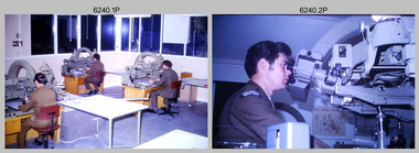
 Bendigo Military Museum
Photograph - Photogrammetric Equipment – Army Survey Regiment, Fortuna, Bendigo, c1960s to c1980s
This is a set of eight photographs of technicians operating photogrammetric equipment in Air Survey Squadron, Army Survey Regiment, Fortuna, Bendigo. c1960s to c1980s. The Wild A9 Stereocomparator and Wild B9 stereo plotter were introduced in 1962. The Wild B8 stereo plotter was introduced in 1966. Technicians used the Wild A9 Stereocomparator to accurately measure between pass, tie, and survey control points on aerial photographs. The Wild B9 and B8s were used for plotting topographic detail and contours. These analogue machines were manually controlled by adjusting the control knobs for the orientation of the 3D image. The B9s used a four and a half square, and the B8s used a nine-inch square photo image on a film or glass diapositive which allowed highly accurate extraction of map features. At first, plotting with B8 and B9 stereo plotters was undertaken at the aerial photography scale of 1:80,000 in pencil onto a controlled plotting sheet. Sheets were then inked up and reduced photographically to the 1: 100,000 publication scale for scribe impression production. In the early days topographic detail and contours were plotted with a pencil or ink pen mounted at the far end of the pantograph arm. The plotting procedure was upgraded to direct plotting in ink with photographic reduction to publication scale. In 1975 four B8s were upgraded with tri-axis locaters as part of the Input Sub-system to enable digital extraction to AUTOMAP 1’s topographic database. When AUTOMAP 2 was introduced in 1982 these B8s were upgraded, and additional machines added to expand the Army Survey Regiment’s digital capture capability. This is a set of eight photographs of technicians operating photogrammetric equipment in Air Survey Squadron, Army Survey Regiment, Fortuna, Bendigo. c1960s to c1980s. Black and white and colour photos are on photographic paper and scanned at 300 dpi. .1) - Photo, black & white, c1965. Unidentified technician operating a Wild A9 Stereocomparator. .2) - Photo, black & white, c1965. Unidentified technician operating a Wild B9 stereo plotter. .3) - Photo, black & white, c1967. L to R: Unidentified technician, SPR Ken Jeffery operating a Wild B9 stereo plotter. .4) - Photo, colour, c1974. Unidentified technician, operating a Wild B8 stereo plotter. .5) - Photo, black & white, c1974. Unidentified technician operating a Wild B8 stereo plotter. .6) to .7) - Photo, black & white, c1979. Unidentified technicians operating a Wild B8 stereo plotter. .8) - Photo, black & white, c1985. Unidentified technician in AUTOMAP 2 operating a Wild B8 stereo plotter..1P, .2P, .4P, .5P, .7P – no annotations. .3P – annotated ‘Standing - , Seated SPR Ken Jefferies (sic). .6P – annotated with date ‘1979’ .8P – annotated ‘AUTOMAP 2’royal australian survey corps, rasvy, army survey regiment, army svy regt, fortuna, asr, air survey, photogrammetry -
 Bendigo Historical Society Inc.
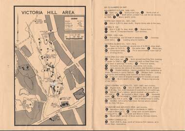
Map - VICTORIA HILL AREA
Map of Victoria Hill Area printed on yellow paper. Details of tracks, cuttings, contours (in Metres) and Anticline. Location of mines, open cuts and buildings are shown. Numbers on map are: Ballerstedt's Claim 1 - 5; North Old Chum Co. 6; Lansell's 180, 7,8,11; Battery 9.10.12; Victoria Quartz Co. 13 - 17; Rae's Open Cut and Vicinity 18 - 28, Great Central Victoria Co 29 - 36, Adventure and Advance Area and vicinity 37 - 40 and Victoria Consols Co 41.map, bendigo, victoria hill, victoria hill area, victoria consols, new chum anticline, great central victoria, rae's open cut, w rae's home, victoria quartz, ballerstedt's open cut, lansell's 180, north old chum, central nell gwynne, john brown factory, gold mines hotel, cleopatra needle type chimney, floyd's battery, ballerstedt's 24yd claim, humboldt shaft, wittscheibe's jeweller's shop, luffsman and sterry's claim, victoria hill reserve, mines dept reervation -
 Kew Historical Society Inc
Map, MMBW, MMBW Plan No.39 Kew & Heidelberg, 1900-1910
The Melbourne and Metropolitan Board of Works (MMBW) was established by an act of the Victorian Parliament in 1890 to prepare for and to implement a sewerage and water reticulation system across what was then inner Melbourne, its surrounding and middle distance suburbs, including Kew. The MMBW was disbanded in 1991.The map collection of the Kew Historical Society has at its core the historic maps assembled and originally stored in the City Engineer's Department of the City of Kew. These include maps in a number of scales. The vast majority of maps were produced by the MMBW in the first two decades of the twentieth century, and are solid working maps, backed by linen for durability. These maps are historically significant to Kew, the City of Boroondara and to the history of the development of state utilities in Victoria. A number of the Kew maps have additional details added by former municipal officers, including the levels reached by various floods. As these were working documents, information was added to them long after the period of their initial production and distribution.Early map of part of the Borough of Kew, created in the first decade of the twentieth century, at a scale 160 ft to 1 inch. The map covers what was then the north western section of Kew, bordered on its north by Wills Street and the Kew Lunatic Asylum, in the west by the River Yarra [and the later added Yarra Boulevard] , by Princess Street in the East and Holroyd Street in the south. The map shows the extent of urban development by that time, prominent institutions and the outlines of built structures in the municipality. Contour lines were added in ink to the map at a later stage.MELBOURNE AND METROPOLITAN BOARD OF WORKS / PLAN NO. 39 / KEW & HEIDELBERGmelbourne & metropolitan board of works, mmbw maps, mmbw plans, borough of kew, cartography -
 Kew Historical Society Inc
Map, MMBW, MMBW Plan No.67 Kew, 1900-1910
The Melbourne and Metropolitan Board of Works (MMBW) was established by an act of the Victorian Parliament in 1890 to prepare for and to implement a sewerage and water reticulation system across what was then inner Melbourne, its surrounding and middle distance suburbs, including Kew. The MMBW was disbanded in 1991.The map collection of the Kew Historical Society has at its core the historic maps assembled and originally stored in the City Engineer's Department of the City of Kew. These include maps in a number of scales. The vast majority of maps were produced by the MMBW in the first two decades of the twentieth century, and are solid working maps, backed by linen for durability. These maps are historically significant to Kew, the City of Boroondara and to the history of the development of state utilities in Victoria. A number of the Kew maps have additional details added by former municipal officers, including the levels reached by various floods. As these were working documents, information was added to them long after the period of their initial production and distribution.Early map of part of the Borough of Kew, created in the first decade of the twentieth century, at a scale 160 ft to 1 inch. The map covers what was then the north central part of Kew, bordered on its north by the Outer Circle Railway Spruzen and Beresford Avenues, in the west by Princess Street, in the south by High Street, and in the east by (about) Belford Road. The map shows the extent of urban development by that time, prominent institutions and the outlines of built structures in the municipality. Contour lines were added in ink to the map at a later stage.MELBOURNE AND METROPOLITAN BOARD OF WORKS / PLAN NO. 67 / KEW melbourne & metropolitan board of works, mmbw maps, mmbw plans, borough of kew, cartography -
 Kew Historical Society Inc
Map, MMBW, MMBW Plan No.68 Kew, 1900-1910
The Melbourne and Metropolitan Board of Works (MMBW) was established by an act of the Victorian Parliament in 1890 to prepare for and to implement a sewerage and water reticulation system across what was then inner Melbourne, its surrounding and middle distance suburbs, including Kew. The MMBW was disbanded in 1991.The map collection of the Kew Historical Society has at its core the historic maps assembled and originally stored in the City Engineer's Department of the City of Kew. These include maps in a number of scales. The vast majority of maps were produced by the MMBW in the first two decades of the twentieth century, and are solid working maps, backed by linen for durability. These maps are historically significant to Kew, the City of Boroondara and to the history of the development of state utilities in Victoria. A number of the Kew maps have additional details added by former municipal officers, including the levels reached by various floods. As these were working documents, information was added to them long after the period of their initial production and distribution.Early map of part of the Borough of Kew, created in the first decade of the twentieth century, at a scale 160 ft to 1 inch. The map covers what was then the north central part of Kew, bordered in the north by Oak Avenue, in the west by the Yarra River and Connor's Creek, in the south by Beresford and Carnegie Avenues, and in the east by Glass's Creek and Burke Road. The map shows the extent of urban development by that time, prominent institutions and the outlines of built structures in the municipality. Contour lines and the levels of historic floods were added in ink to the map at a later stage.MELBOURNE AND METROPOLITAN BOARD OF WORKS / PLAN NO. 68 / KEW melbourne & metropolitan board of works, mmbw maps, mmbw plans, borough of kew, cartography -
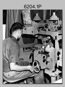
 Bendigo Military Museum
Photograph - Photogrammetric Equipment – Army Survey Regiment, Bendigo and School of Military Survey Bonegilla, c1960s to c1980s
This is a set of 14 photographs of RA Svy technicians operating photogrammetric equipment in Air Survey Squadron, Army Survey Regiment, Fortuna, Bendigo; and the School of Military Survey Bonegilla c1960s to c1980s. The Wild B9 stereo plotter were introduced in 1962 and the Wild B8 stereo plotter was introduced in 1966. The Wild B9 and B8 stereo plotters were used for plotting topographic detail and contours. These analogue machines were manually controlled by adjusting the control knobs for the orientation of the 3D image. The B9s used a four and a half square, and the B8s used a nine-inch square photo image on a film or glass diapositive which allowed highly accurate extraction of map features. At first, plotting with B8 and B9 stereo plotters was undertaken at the aerial photography scale of 1:80,000 in pencil onto a controlled plotting sheet. Sheets were then inked up and reduced photographically to the 1: 100,000 publication scale for scribe impression production. In the early days topographic detail and contours were plotted with a pencil or ink pen mounted at the far end of the pantograph arm. The plotting procedure was upgraded to direct plotting in ink with photographic reduction to publication scale. In 1975 four B8s were upgraded with tri-axis locaters as part of the Input Sub-system to enable digital extraction to AUTOMAP 1’s topographic database. When AUTOMAP 2 was introduced in 1982 these B8s were upgraded, and additional machines added to expand the Army Survey Regiment’s digital capture capability. There are several more photos catalogued in the Victorian Collections database of RA Svy personnel operating Wild B9 and B8 stereo plotters.Photogrammetric Equipment – Army Survey Regiment, Fortuna, Bendigo c.1981. . .7) – Unidentified technician operating Wild B8 stereo plotter in AUTOMAP 1 at ASR. .8) - Wild B8 stereo plotter in AUTOMAP 1 at ASR. Photogrammetric Equipment – Army Survey Regiment, Fortuna, Bendigo. c1981. .9) – ASR’s CPL Dave Cook in AUTOMAP 1 operating a Wild B8 stereo plotter. This is a set of 14 photographs of RA Svy technicians operating photogrammetric equipment at the Army Survey Regiment (ASR), Bendigo and the School of Military Survey (SMS) Bonegilla. c1960s to c1980s. The photographs are on 35mm colour slides and were scanned at 96 dpi. .1) - Photo, colour, c1964. Unidentified ASR technicians operating analogue Wild B9 stereo plotters. .2) - Photo, colour, c1974. ASR’s SPR Mick Minchin operating an analogue Wild B8 stereo plotter. .3) to .6) - Photo, colour, c1980. Photogrammetry Instructor SGT Neil ‘Ned’ Kelly at the SMS operating an analogue Wild B8 stereo plotter. .7) - Photo, colour, c1981. Unidentified technician operating Wild B8 stereo plotter in AUTOMAP 1 at ASR. .8) - Photo, colour, c1981. Wild B8 stereo plotter in AUTOMAP 1 at ASR. .9) to .14) - Photo, colour, c1981. ASR’s CPL Dave Cook in AUTOMAP 1 operating a Wild B8 stereo plotter..1P to .14P - Some of the equipment is annotated on the frame of the 35mm slides.royal australian survey corps, rasvy, army survey regiment, army svy regt, fortuna, asr, photogrammetry -
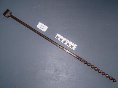 City of Moorabbin Historical Society (Operating the Box Cottage Museum)
Tools, steel spiral bit Auger, c1900
Before drills and braces, T-shaped augers were used to poke holes into wood, while smaller gimlets were used to start them. Auger handles were usually made of a piece of hardwood that was sanded, rounded, or even contoured to give the user a firm grip. Bits on spoon augers essentially carved a hole in the piece of wood, and had to be periodically removed to clear the chips. Spiral-bit augers were precursors to modern drills, whose bits cleared the hole of chips as the user drilled. A significant advance on the auger was the brace, which was originally designed with a single, permanently fixed bit at its end. Eventually, though, braces were designed with sophisticated chucks to accommodate replacement bits, as well as bits of different sizes and for various purposes A steel spiral bit Auger* pioneers, early settlers, market gardeners, moorabbin, bentleigh, cheltenham, brighton, tools, craftsman, carpenters, , blacksmiths, builders, farmers, metalwork, woodwork, drills, augers, gimlets