Showing 1713 items
matching counties
-
 Stawell Historical Society Inc
Map, Warranook, County of Borung, Shire of Stawell, 1959
Warranook, County of Borung, Shire of Stawellstawell -
Stawell Historical Society Inc
Map, William, County of Borung, Shire of Stawell, 1945
William, County of Borung, Shire of Stawellstawell -
Stawell Historical Society Inc
Map, County of Kara Kara Marnoo / Callawadda
County of Kara Kara Marnoo / Callawaddastawell -
Tatura Irrigation & Wartime Camps Museum
Folder - family history, Crawford Family History, 1998
Crawford family crest on cover of folder of Crawford Family TreeFamily history of Crawford descendants from IrelandDescentants of Andrew Crawford of Newtown - Stewart. County Tyrone, Irelandcrawford, crawford jg, tatura, documents, biography -
 Bendigo Historical Society Inc.
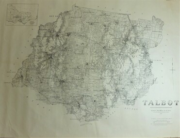
Map - JACK FLYNN COLLECTION: TALBOT, 1937
Map: County of Talbot, map sheet showing the whole of the County of Talbot and all of the Parishes within. Scale 2 Miles to 1 inch.By Authority: A.C. Brooks, Government Printer, Melbourne. Department of Lands and Survey Melbourne. 1959map, talbot, county, talbot -
 Federation University Historical Collection
Document, Frank Wright, Handwritten lecture 3/2/1964, 3/2/1964
Frank Wright was a renown resident of Smeaton, where he was born on 2 August 1901. He lived at Laura Villa, and attended Smeaton State School. His father William was a gold miner and his mother's name was Sarah. Their family won many singing and instrumental awards. Frank was tutored by Percy Code and was awarded a gold medal for the highest marks in the ALCM examinations in the British Colonies at the age of seventeen years. He became the Australian Open Cornet Champion by the age of eighteen. A year later, Frank conducted the City of Ballarat Band, and later the Ballarat Soldiers’ Memorial Band. He formed the Frank Wright Frisco Band and Frank Wright and his Coliseum Orchestra. These bands won many South Street awards, and Frank as conductor won many awards in the Australian Band Championship contest. In 1933 Frank Wright sailed to England to conduct the famous St Hilda’s Band and was later appointed Musical Director of the London County Council, where he organized many amazing concerts in parks, in and around the London district. He was made Professor of Brass and Military Band Scoring and conducted at the Guildhall of Music and Drama. Frank was often invited to adjudicate Brass Band Championships around Europe, in Australia, including South Street and in New Zealand. The Frank Wright Medal at the Royal South Street competition is awarded to an individual recognized as making an outstanding contribution to brass music in Australia.A 6 page handwritten lecture on lined foolscap paper pertaining to the history of band performances in the London County Council parks.All handwritten in blue and red pen with some pencil additions. frank wright, brass bands, greater london county council parks department, conductor -
 Wodonga & District Historical Society Inc
Map - Tulloch & Brown's Map of the Colony of Victoria, Tulloch & Brown, 1856
The map was created by Tulloch and Brown. David Tulloch was one of the earliest engravers and lithographers in the state of Victoria. He arrived in Melbourne from Greenock, Scotland, on 3 January 1849. Following the discovery of gold Tulloch went to the Victorian goldfields in 1851, commissioned to make sketches of the diggers and the diggings for Ham’s Illustrated Australian Magazine. In November 1852 Tulloch set up in business as engraver, draughtsman, copperplate printer and lithographer. Tulloch took a map engraver, James Davie Brown, into partnership in March 1853; the several maps and specimens of commercial engraving they showed at the 1854 Melbourne Exhibition were awarded a bronze medal. That year Tulloch and Brown also received a silver medal at the Victorian Industrial Exhibition. The partnership was dissolved towards the end of 1856.This is a very early map of the Colony of Victoria including Belvoir (now know as Wodonga).A foldable map mounted on linen and with a board cover. It records the Colony of Victoria according to Surveyor's Records revised in 1857. Areas of the map are shaded to highlight different counties.At bottom right hand section of map: Tulloch & Brown's map of the Colony of Victoria : comprising part of New South Wales, the boundaries, counties, also seaport & inland townships, the gold fields with the latest discoveries, roads, tracks, &c. &c. / compiled from drawings in the Survey Office and correctly revised till 1857. Respectfully dedicated by Permission, to the Honorable Captain Andrew Clarke R.E. Surveyor General of Victoria by His Obediant Servants Tulloch & Brown, Engravers & Publishers, Melbourne". At bottom right below border : Published as the Act directs by the Proprietors, Melbourne, 1st Feb. 1856. tulloch and brown maps, rare maps victoria, victorian cartography -
 National Wool Museum
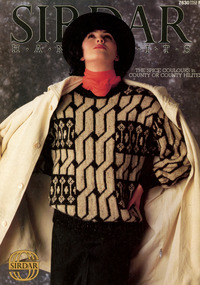
Book - Pattern Book, Sirdar Knitting Book, No. 7630, Sirdar Wools (Australia) Pty Limited, 1990s
Twelve page knitting pattern book featuring black and white text and colour images. The colour cover features a woman wearing a knitted jumper.front: [printed] 7630 / PRICE / CODE / F / SIRDAR / H A N D K N I T S / THE SPICE COULOURS in / COUNTY OR COUNTY HILITES / SIRDARfashion, design, knitwear, home made, wool, pattern book, sirdar -
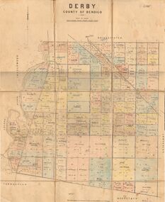
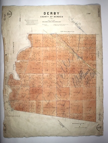
 Bendigo Historical Society Inc.
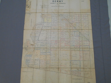
Map - JACK FLYNN COLLECTION: DERBY, 12/05/1892
Map: Derby, County of Bendigo. Parish plan.Department of Lands and Survey Melbourne by T.F.McGauran, 12.5.92map, bendigo, parish plan, derby -
 Bendigo Historical Society Inc.
Map - JACK FLYNN COLLECTION: DERBY, 1/09/1909
Map: Derby, County of Bendigo. Parish plan.Dept of Lands and Survey, Melbourne by T.E.McGauran 1.9.09map, bendigo, parish plan, derby -
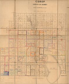 Bendigo Historical Society Inc.
Map - JACK FLYNN COLLECTION: COROP, 8/08/1929
Map: Corop, County of Rodney. Parish plan.By Authority H. J. Green, Govt. Printer, Melb. Dept of Lands and Survey Melbourne by Price 8.8.29map, rodney, parish plan, corop, county of rodney -
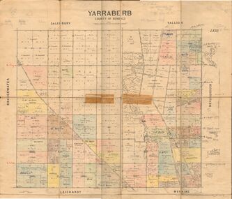 Bendigo Historical Society Inc.
Map - JACK FLYNN COLLECTION: YARRABERB, 2/03/1931
Map: Yarraberb, County of Bendigo. Parish plan.By Authority H.J. Green Govt., Printer. Photo Lithographed at the Department of lands and Survey Melbourne, 2.3.31.map, bendigo, parish plan, yarraberb -
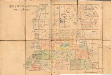 Bendigo Historical Society Inc.
Map - JACK FLYNN COLLECTION: BRIDGEWATER, 6/10/1927
Map: Bridgewater , County of Bendigo. Parish plan.Photo Lithographed at the Department of Lands and Survey, Melbourne by W.J. Butson.map, bendigo, parish plan, bridgewater -
Bendigo Historical Society Inc.
Map - COLBINABBIN, June 1951
Map: Colbinabbin, County of Rodney. Parish planmap, rodney, parish plan, colbinabbin, county of rodney -
Stawell Historical Society Inc
Map, Great Western, Parish of Concongella, County of Borung, 1958
Great Western, Parish of Concongella, County of Borungstawell -
Stawell Historical Society Inc
Map, Malakoff, County of Kara Kara, Shire of Stawell, 1921
Malakoff, County of Kara Kara, Shire of Stawellstawell -
Stawell Historical Society Inc
Map, Wallaloo, County of Kara Kara, Shire of Stawell, 1920
Wallaloo, County of Kara Kara, Shire of Stawellstawell -
Stawell Historical Society Inc
Map, Warngar, County of Kara Kara, Shire of Stawell, 1957
Warngar, County of Kara Kara, Shire of Stawellstawell -
Stawell Historical Society Inc
Map, Warra Warra, County of Borung, Shire of Stawell, 1957
Warra Warra, County of Borung, Shire of Stawellstawell -
Stawell Historical Society Inc
Map, Watta Wella, County of Borung, Shire of Stawell, 1957
Watta Wella, County of Borung, Shire of Stawellstawell -
Stawell Historical Society Inc
Map, Township of Moyston, Parish of Moyston, County of Borung, 1956
Township of Moyston, Parish of Moyston, County of Borungstawell -
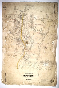 Bendigo Historical Society Inc.
Map - MANDURANG, 10/11/1909
Map: Mandurang, County of Bendigo. Parish planmap, bendigo, parish plan, mandurang -
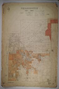 Bendigo Historical Society Inc.
Map - NEILBOROUGH, 27/09/1904
Map: Neilborough, County of Bendigo. Parish planmap, bendigo, parish plan, neilborough -
 Bendigo Historical Society Inc.
Map - DERBY, 12/05/1892
Map: Derby, County of Bendigo. Paris planmap, bendigo, parish plan, derby -
Whitehorse Historical Society Inc.
Document, Certificate of Title, 1917 - 1933
Certificate of Title, Harrison Rotherham of 'Thulecroft', Albion Street, Surrey Hills, Merchant.Certificate of Title, Harrison Rotherham of 'Thulecroft', Albion Street, Surrey Hills, Merchant. Lots 61 & 62, subdivision 602, Part of Crown Allotment 127, Parish of Nunawading, County of Bourke with a right of carriage way over Harrison and Burnett streets, 1917. Vol 4046, Fol 809049. Also correspondence re rates, enforcement of charge, 1933.Certificate of Title, Harrison Rotherham of 'Thulecroft', Albion Street, Surrey Hills, Merchant.land titles, shire of nunawading, shire of blackburn and mitcham, rotherham, harrison, harrison street, mitcham, burnett street, mitcham -
Whitehorse Historical Society Inc.
Document, Certificate of Title, 1910, 1928, 1933
Certificate of Title, Albert Edward Ruglen.Certificate of Title, Albert Edward Ruglen. Part of Crown Allotment 118A, Parish of Nunawading, County of Bourke, 1910. Vol 3462 fol 692315 also correspondence re rate enforcement of charge. Another certificate of title for the same person, subdivision 12279, vol 5389 fol 1077705 1928 and rates - enforcement of charge 1933.Certificate of Title, Albert Edward Ruglen.ruglen, albert edward -
 Bendigo Historical Society Inc.
Map - JACK FLYNN COLLECTION: KARA KARA, 1932
Map: County of Kara Kara, map sheet showing the whole of the County of Kara Kara and all of the Parishes within. Scale 2 miles to 1 inch.By Authority: W.M. Houston, Government Printer Melbourne. Department of Lands and Survey, Melbourne, 1958map, kara kara, county, kara kara -
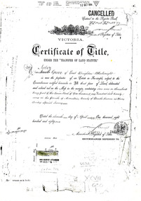 City of Moorabbin Historical Society (Operating the Box Cottage Museum)
Document - Photocopy of Land Title 1881, c1881
This is a Certificate of Title for an acre of land in 'Tucker's Road' purchased by Jabez Gurr in 1881, in the area that was part of the Crown Block known as Henry Dendy's Special Survey 1841, in the Parish of Moorabbin, County of Bourke, Victoria. Following the 'Transfer of Land Statute' allotments in the area of Henry Dendy's Special Survey of 1841 were sold to early settlers. This Certificate of Title shows the passage of history in Moorabbin Shire . Jabez Gurr, a wheelwright, of East Brighton, now Bentleigh East, purchased an acre of land in 'Tucker's Road' , near Centre Road, in 1881. In 1889 he sold to a produce merchant, Robert Smith, and in April 1916 this block was purchased by William Henry George Box, a market gardener and relative of William and Elizabeth Box, who owned the land until 1926. The land was then purchased by Charles John Greenlaw Coates and remained with this family until 1971. All these Family names appear on Councils and Community Boards during the foundation and development of City of Moorabbin3 photocopied pages of the Certificate of Title for approximately 1 acre of land near the corner of Centre Road and Tucker Road, Parish of Moorabbin, County of Bourke, Victoria that was part of the 5,120 acre Henry Dendy Special Survey in Brighton in 1841 and purchased in 1881 by Jabez Gurr. It records subsequent proprietors up to 1971Stamped CANCELLED 12 OCT 1994 (top Right) / Entered in the Register Book / Vol.1245 Fol. 248877/ signed Henry Crowe / Assistant Registrar of Titles / Coat of Arms / VICTORIA / Certificate of Title / UNDER THE ' TRANSFER OF AND STATUTE' /dated ' eleventh day of April one thousand eight / hundred and eighty one' / signed 'Henry Crowe' / Assistant Registrar of Titles/ ENCUMBRANCES REFERRED TO / circular Stamp 'OFFICE OF TITLES VICTORIA' / Drawn and shaded on the left side is the area of land in "Tucker's" Road 3331/3 links fro Centre Road, 150 links x 6662/3 links / The measurements are in linksdendy henry, dendy's special survey 1841, brighton, moorabbin, bentleigh, market gardeners, early settlers, pioneers, wheelwrights, merchants, fruit gardens, markets, smith robert, box william henry george, gurr jabez, county of bourke, victoria, melbourne, land statutes, tucker road, centre road, box william, box elizabeth, box cottage museum -
 City of Moorabbin Historical Society (Operating the Box Cottage Museum)
Document, laminated List of Pioneers Moorabbin Parish, c1985
This list shows the names of the Pioneer settlers with the amount of Acres, the date purchased from The Crown and the Lot or Portion Number in the Land of the Henry Dendy Special Survey of Brighton 1841, in the County of Bourke , Victoria. The Squatters ,who arrived in the area first, used the land for grazing sheep and cattle. The Squatters had the right to graze unoccupied Crown land for ₤10 per year rental and a per capita payment for animals grazed. They could develop , improve and clear the land for the purpose of the tenancy but ownership was not permitted. When the land became useful The Crown put it on the market and the developers took over whilst the Squatters lost the improved land, dwellings and out buildings, there being no compensation paid. Squatters named John and Thomas Martin 1840-41; Richard and John King 1840- 1854 ; M.N.M.Moysey and M.J.Bickford 1841-1852 ; James McMahon 1846-1853 ; Daniel MacKinnon 1839- 1840. The 5120 Acres of the Henry Dendy Special Survey 1841were divided into approx. 83 Portions / Lots with varying acreage . Josiah Holloway, a speculator purchased 625 acres of the King Brothers run and re-sectioned the land into 2 acre Lots for Sale as market gardens. It was called The Two Acre Village later known as Cheltenham. A List of the names of The Pioneers in County of Burke Victoria c1841-1887 compiled by Lesley A. Schumer in 1985 A 3 Laminated display on wall in room 2 THE PIONEERS, Signed L.A. Schumer moorabbin, brighton, cheltenham, bentleigh, market gardeners, pioneers, early settlers, dendy henry, henry dendy's special survey 1841, squatters, king john, martin john, mcmahon james, two acre village, holloway josiah, were jonathan binn, grazing, cattle, sheep, market gardens, -
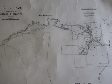 Kiewa Valley Historical Society
Map - Freeburgh - Counties of Bogong and Delatite
Drawn and reproduced at the Dept. of Lands and Survey, Melbourne, Victoria November 1948Black and white map of Freeburgh, County of Bogong and Delatitefreeburgh, map county of bogong and delatite