Showing 2862 items matching "early buildings"
-
 Hume City Civic Collection
Photograph, early 1990s
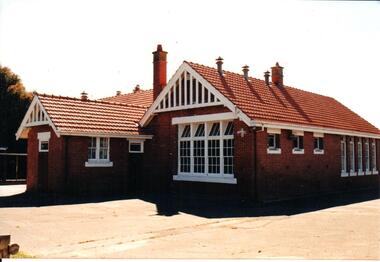
... and replaced an earlier school building. In 1942/43 the school building... and replaced an earlier school building. In 1942/43 the school building ...The brick building was constructed in 1911/1912 and replaced an earlier school building. In 1942/43 the school building was extended to cope with the increased population in Sunbury. The State School remained on the Macedon Street site until 1999 when it was relocated to the restored former Industrial School at Jacksons Hill.A coloured photograph of the former Sunbury State School No. 1002. It is a red brick Federation building with a red terracotta tiled roof and wooden white painted trims. There are two stepped brick chimneys with terracotta chimney pots and six air vents protruding from the roof. There is a small porch at the front of the building.carirns, j. f. dr., eadie, peter, education department, george evans collection -
 Bendigo Historical Society Inc.
Photograph - BENDIGO HOTEL COLLECTION: TYSONS REEF HOTEL, WEEROONA AVENUE, BENDIGO
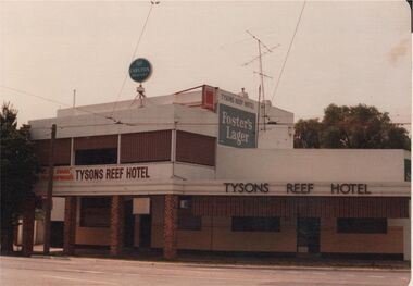
... in brown paint in two places on front of building. Early 1980's ?... Hotel in brown paint in two places on front of building. Early ...Colour photograph: Two storey building, with single storey section on RH side, plain façade, white painted, unpainted brick verandah supports to edge of footpath. Tysons Reef Hotel in brown paint in two places on front of building. Early 1980's ?bendigo, hotel, tysons reef -
 Linton and District Historical Society Inc
Photograph, Traquair House, Sussex Street, Linton, 2014
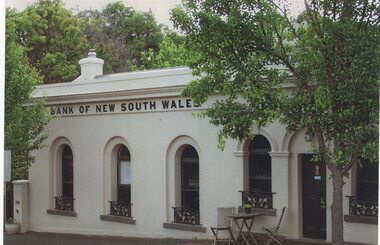
... the earlier building became a private residence. It was lived... the earlier building became a private residence. It was lived ...The original bank and residence were built in 1862, and the building was extended in 1873-74. The three windows on the left of the photograph are in the original building, and the windows and door on the right of the photograph are in the extension. The brick building was cement-rendered at an unknown later date. In 1904 the Bank of New South Wales built a new banking chamber & residence on the west side of Sussex Street next to the Post Office, after which the earlier building became a private residence. It was lived in for many years by members of the Lewers family (Samuel Lewers had been first manager of the Bank of NSW in Linton) and was purchased in the early 1960s by Stella Surman (née Todd). More recently it has been used as an antique shop and tea rooms, and it is currently a private residence. This photograph was taken in 2014 by Gary Hunt.One of three colour photographs printed on a single sheet of photographic paper. The photograph shows Linton's first Bank of New South Wales building, now called Traquair House.traquair house, 90 sussex street linton, buildings, houses, bank of new south wales -
 Ballarat Tramway Museum
Negative, Wal Jack, early 1960's
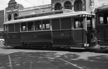
... is the Hartley Sports Centre and the Ballaarat Gas Co. buildings... and the Ballaarat Gas Co. buildings. Photo early 1960's. Negative Wal ...Yields information about Ballarat No. 14 parked in the city loop during the early 1960's.Negative and Digital images of the Wal Jack Ballarat Negative file of No. 14 in the City Loop. In the background is the Hartley Sports Centre and the Ballaarat Gas Co. buildings. Photo early 1960's.trams, tramways, sturt st, city loop, tram 14 -
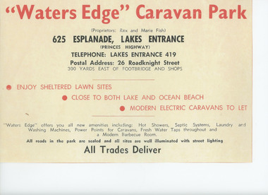 Lakes Entrance Historical Society
Album - Waters Edge Camp Park, Marie Fish, 1962 to 1975
... of brown covered photograph album with 60 photographs of building... covered photograph album with 60 photographs of building and early ...Park owned by Rex and Marie FishAdvertisement for Waters Edge Caravan Park in first page of brown covered photograph album with 60 photographs of building and early days of Waters Edge Camp Park Lakes Entrance Victoriabusinesses, camping, tourism -
 Kiewa Valley Historical Society
Photographs – Bogong High Plains - Set of 16 black and white photographs mounted back and front on 3 pieces of heavy black card likely removed from a photograph album
... . 2 photographs- arranged diagonally on page showing early.... 2 photographs- arranged diagonally on page showing early ...After World War II, the Kiewa Hydro-Electric Scheme was started in the Kiewa River Valley by the State Electricity Commission of Victoria. On land previously used only for summer cattle grazing in the natural alpine grasslands, the first ski lodge was built in 1948 by workers from the hydro scheme as skiing was a popular recreation. Many of the hydro employees were of European background and had grown up enjoying skiing and snow sports in their homelands and were keen to continue to pursue their winter sports interests. The first lift, a rope tow, was built at Falls Creek in 1951 and the first chairlift in Australia was constructed there in 1957. Two T-Bars were opened in 1961. In 1964, the Victorian Municipal Directory recorded that Falls Creek had 29 ski club lodges and 16 commercial lodges. The area became a popular tourist destination for both winter and summer sports.Employees of the State Electricity Commission of Victoria in the Kiewa River Valley were the earliest skiers on the Bogong High Plains and built one of the first ski lodges at Falls Creek. They were amongst those pivotal in the development of the skiing and tourist industry at Falls Creek and on the Bogong High Plains. Black and white photographs of varying sizes mounted decoratively on heavy black Card. Some pages display a brief description printed in white ink 1. 4 photographs- displayed diagonally across page. 2 pictures of a group of men standing in the snow in front of a car with a loaded trailer behind. 1 photo of skiers. 1 photo of show hanging in tree branches. 2. 2 photographs- showing Upper Kiewa Road with snow in the background 3. 3 photographs- of skiers and 1 photo of 2 of men posing in the snow & 1 photo of 2 men posing shirtless in warmer weather. 4. 2 photographs- arranged diagonally on page showing early buildings and construction at Bogong Village 5. 2 photographs- 1 showing view of Bogong Village from higher up the mountain. 1 showing early Bogong High Plains road 6. 1 photograph- showing view down along Kiewa Valley from higher up in the mountains 1. Handwritten in white ink – A TRIP TO THE PLAINS 2. Handwritten in white ink – UPPER KIEWA ROAD MT FAINTER IN BACKGROUND 3 – 6. No markings bogong village; upper kiewa road; bogong high plains; falls creek; skiers -
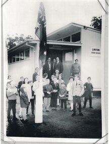 Linton and District Historical Society Inc
Photograph, Opening Day, New Linton School Building, 1969
... the earlier brick school building, this building was afterwards... the earlier brick school building, this building was afterwards ...Although plans had been drawn up in 1966 to renovate the earlier brick school building, this building was afterwards declared unsafe, and a new "modular" building was erected in 1969.Copy of original black and white photograph which shows a group of pupils, teachers, dignitaries and others outside the new Linton State School building, on its official opening day 8th September 1969.linton state school no. 880, opening day 1969, new building -
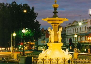 Bendigo Historical Society Inc.
Photograph - PURDY COLLECTION: PHOTO OF ALEXANDRA FOUNTAIN
... early 2000's. Beehive building on RH side, looking north... to be recent photo, possibly early 2000's. Beehive building on RH side ...Colour photo of Alexandra Fountain, Bendigo. Fountain illuminated, night picture. Appears to be recent photo, possibly early 2000's. Beehive building on RH side, looking north on Pall Mall.bendigo, streetscape, pall mall -
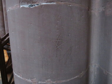 Ballarat Heritage Services
Photograph - Colour, Dorothy Wickham, Mason's Marks, Carlisle Cathedral 27 October 2016, 2016
... was founded in 1122 by King Henry I. There were earlier buildings... the cathedral was founded in 1122 by King Henry I. There were earlier ...Carlisle Cathedral The Priory near the cathedral was founded in 1122 by King Henry I. There were earlier buildings on the site. Ten years later the priory church became the Cathedral and the Kind created the diocese of Carlisle. The building is constructed of red sandstone. Celebrated architect Ivo de Raughton who lived a few miles south of Carlisle designed the intricate masonry. Many interesting features are recorded about Carlisle Cathedral in tourist brochures and its homepage, however they do not mention the many mason’s marks clearly visible on the stone columns inside the Cathedral. There have been hundreds of marks recorded, some being similar to those on the Yarrowee Channel in Ballarat. A pentagram (sometimes known as a pentalpha, pentangle or star pentagon) is the shape of a five-pointed star. They were known as apotropaic or witch's marks and were thought to ward off evil spirits. Digital photographApotropaic mark carved into columncarlisle, cathedral, stonemasons, mason's marks, apotropaic mark, witch's mark -
 University of Melbourne, Burnley Campus Archives
Photograph - Black and white print, Information Branch, Victorian Department of Agriculture, Principal's House, 1900-1909
... of the early college buildings outstanding." In different handwriting... leaving none of the early college buildings outstanding ...Therefore the earlier comment about seated man would not be correct.2 copies black and white photograph. House and surrounding garden. Building is of stucco and timber, slate roof, 4 chimneys. The original sections of the house date from 1872. The seated gentleman on a bench in front of the house is probably Mr. E.E. Pescott.Reverse of larger copy, "from box the Garden/Land 1909." On reverse of smaller copy, "Photograph by Information Branch Victorian Department of Agriculture Ref. No. 1981(889-2.)" Further copy: handwritten on reverse, "Early 1900 certainly before 1909. Caption "Directors residence (1909) was a major feature of the garden. sadly it was demolished in 1980 now leaving none of the early college buildings outstanding." In different handwriting, "Principals House before 1909."e.e. pescott, principal's residence, principal's house -
 Round the Bend Conservation Co-operative
Another early Co-op building was referred to as the Humpy. It was used as a pottery studio
... Another early Co-op building was referred to as the Humpy...Another early Co-op building was referred to as the Humpy... in mud brick. Band White Photo Another early Co-op building ...Another early Co-op building was referred to as the Humpy. It was used as a pottery studio. Originally a weatherboard building built by Chris Mueller in 1973-74, it eventually started to deteriorate and was clad in mud brick. Band White Photo -
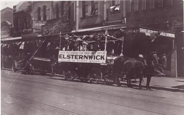 Glen Eira Historical Society
Photograph - ELSTERNWICK
... of early Elsternwick buildings and railway reserve c. 1901. 2/2... Photocopied photographs of early Elsternwick buildings and railway ...This file contains 15 items: 1/5 Photocopied photographs of early Elsternwick buildings and railway reserve c. 1901. 2/2 Photocopied photos and one original photo of local transport in Elsternwick c. 1908, and one print of Nettie Palmer on a bicycle in Elsternwick in 1902. 3/7 coloured photographs of painted signage on buildings in Elsternwick uncovered in 1989.elsternwick, forests, timber, elsternwick post office, elsternwick railway reserve, hampton albert g., motorcars, motorvehicle repair shops, taxis, beavis street, davenport ron, carre street, wagons, johnson mr., grocers, signs, higgins james, tarrier, blacksmith, palmer nettie, bicycles -
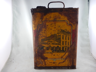 Parks Victoria - Days Mill and Farm
Container - Can
... with an image of a Victorian style building with early cars out... graphics with an image of a Victorian style building with early ...Found in an above ground rubbish pile at Days Mill and farm. The can was used to contain oil and probably used on site.Tall can with squared sides and wire handle at the top and a hole for pouring with intact cork. Yellow and red graphics with an image of a Victorian style building with early cars out the front. "RAMSAY & TREGANOWAN" and "XL OILS" written on the building yeswilliam day, ann day, joseph day, robert day -
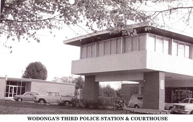 Wodonga & District Historical Society Inc
Photograph - Codling Collection 01 - Wodonga's 3rd Police Station and Court House
... House had to be relocated after the earlier building had been... to be relocated after the earlier building had been destroyed by a fire ...Miss Olive Codling was a Foundation Member and a Life Member of the Wodonga Historical Society. Many of her prize-winning photos are held in the Society Collection. She also held a range of roles and committee positions in a wide range of Wodonga community organisations. WODONGA's 3rd Police Station and Court House were constructed in Elgin Street, Wodonga. The Court House had to be relocated after the earlier building had been destroyed by a fire in 1964. In 1966, the new Wodonga Police Station was built but lay empty and idle for about three months. The reason given was that no furniture was available. After this situation was remedied the station was opened on December 23, 1966. The previous police station was vacated and pulled down. The new station was built in front of the new court house, which had been operating for approximately 12 months. The Police and Court House continued to operate on this site until they were again relocated in 2002. They are now located in Hovell Street, Wodonga.This photo collection is significant as it documents how the businesses and buildings in Wodonga have evolved and contributed to community throughout the 20th century.2 images of the 3rd police station built in Wodonga with the courthouse in the background.wodonga businesses, wodonga police station, wodonga court house -
 Surrey Hills Historical Society Collection
Photograph, Holy Trinity Church of England, Surrey Hills post 1926, After 1926
... is the earlier church. Both buildings are bounded by a simple post... up the hill is the earlier church. Both buildings are bounded ...St George's Church of England, Mont Albert was built in 1886 and from 1904 until 1907 was known as Holy Trinity, Surrey Hills. As the population increased there was a need for a church in Surrey Hills. This brick church was consecrated in 1922 and replaced the earlier one built in 1907 on the adjacent site in Union Road. After construction of the brick church, the earlier one became a Sunday School. The copper spire was added in 1926, which dates this photo as post-1926. Norman Carter took many photos of Surrey Hills and Mont Albert in the 1920s; many were associated with events and activities of the Church of England.Black and white photo of the 'newly' constructed brick Holy Trinity Church in Union Road, Surrey Hills taken from near the south-west corner of Guildford Road. Further up the hill is the earlier church. Both buildings are bounded by a simple post and rail fence. Immature street trees are planted on both sides of Union Road.churches, holy trinity church, anglican church, sunday schools, norman carter -
 Stawell Historical Society Inc
Photograph, Baptist Church members at a Picnic c.1930s - 2 photos plus earlier photo
... in front of a stone building. The earlier photo in a circular frame... in front of a stone building. The earlier photo in a circular frame ...Baptist Church members Picnic Groups (3 photos) Probably Halls Gap. Group probably beside Baptist Church c. 1900sThree black & white photos depicting groups of people. Two are the same and one of older period. One photo is of 12 women seated in front of a stone building. The earlier photo in a circular frame is of 9 people in a group in front of a brick building.stawell -
 Sunbury Family History and Heritage Society Inc.
Photograph, The Royal Hotel, C1939
... an earlier single storey building that was destroyed by fire in 1935... an earlier single storey building that was destroyed by fire in 1935 ...The two storey building is the Royal Hotel which replaced an earlier single storey building that was destroyed by fire in 1935. It stood on a corner at the intersection of Brook and Evans Street. The new hotel was completed and opened in 1939 on the same site and still functions as a hotel today. The Royal Hotel was has occupied the same site in Sunbury's shopping strip for 163 years.A non-digital black and white photograph with a cream border of a brick two storey hotel with white trims around the windows and doors. The building occupies a street corner in a shopping centre.hotels, brook street, evans street, royal hotel -
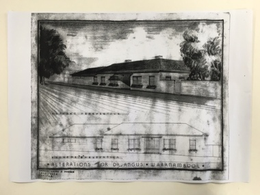 Warrnambool and District Historical Society Inc.
Document, Dr Angus residence plans, 1939
... , Rostrum and the National Fitness Council). Birchwood or earlier..., Rostrum and the National Fitness Council). Birchwood or earlier ...These are plans for alterations to the residence and surgery of Dr Angus in Koroit Street, Warrnambool (Birchwood). Dr William Roy Angus (1901-1970), after several years practising as a doctor in South Australia and northern Victoria, came to Warrnambool in 1939, purchasing the practice of Dr John Hunter Henderson (Birchwood). Dr Angus was a dominant figure in medical and community circles in Warrnambool for 30 years, becoming an important ophthalmologist in his later years. Birchwood, with its beautiful gardens, lawns and tennis court was suitable for entertaining and many distinguished people, including Vice-Regal personnel and representatives of the Red Cross stayed at the house. It was also a meeting place for representatives of the many organizations with which Dr Angus was associated (over 20 groups including the Good Neighbour Council, the Boys’ Club, the Food For Britain appeal, the Historical Society, Rostrum and the National Fitness Council). Birchwood or earlier buildings on the site was used as a residence/surgery by many doctors in Warrnambool, going back to the 1860s and Dr Angus and his family lived there from 1939 to 1967. In 1998 Birchwood was demolished and a new Warrnambool Police Station was built on the site. These plans are of interest as they show the 1939 alterations to the building known as Birchwood in Koroit Street Warrnambool. We have a good floor plan and a drawing of the front of the building so we know what it looked like in the late 1930s. Both Birchwood and Dr Angus are important in Warrnambool’s history. These are four sheets showing alterations for the residence of Dr Angus (Birchwood) in Koroit Street Warrnambool. One sheet shows the front of the house in colour drawn in ink and pencil and paint and there is a copy of this in black and white. The other drawing is of the plans for the house drawn in pencil and ink and with some red and blue colouring. There is another exact copy of this sheet. dr william roy angus, birchwood, history of warrnambool -
 Warrnambool and District Historical Society Inc.
Archive - Door plate with Inscription, Leslie O'Callaghan, 1942
... Street, noting the lay-out of the early building and other... Street, noting the lay-out of the early building and other ...This door plate was found at 28 Spence Street, Warrnambool by the builder Ray Hollingsworth, when he was renovating the building for the Warrnambool Presbyterian Church in June 2019. He realized that the inscription had been placed there by Leslie O'Callaghan, probably when he left the premises in 1942 after boarding there for some years. Leslie O'Callaghan (1918-2014) was born in Balmoral and left there at the age of 13 with a scholarship to study at Warrnambool Technical School. He became an industrial chemist, working at the Kraft Walker Cheese Factory in Allansford (Warrnambool Cheese and Butter Factory). His experimental work in cheese cultures over a 45 year period was regarded as cutting edge work in the Victorian dairying industry. Known as 'Mr History', Leslie O'Callaghan was also an important Warrnambool historian, serving as president of the Warrnambool and District Historical Society for 35 years. In later life Les wrote about his time in 28 Spence Street, noting the lay-out of the early building and other boarders at the time. He never mentioned the interesting memento of his time there that he left on the back of a door plate. The Warrnambool and District Historical Society Archives Centre is called 'Les O'Callaghan History House'This door plate with its inscription was found 77 years after the inscription was written. It is of considerable interest because the writer of the inscription was well-known in Warrnambool as a bacteriologist and an historian. He left his own personal historical message and by sheer chance it was found years later. (All the old door plates at the time of the renovation were thrown out and it was fortunate that the builder happened to see the writing on one of them and to recognize who the writer was.)This is a cream-coloured ceramic door plate. It is rectangular-shaped with curved edges at the top and bottom. It has been painted white and has two holes at the top and bottom for the insertion of screws for a5taching the plate to the door. The inside of the plate has handwriting in black pencilLeslie Alexander O'Callaghan lived here for some years 1939-1942 AD. His occupation was as assistant bacteriologist for Kraft-Walker Cheese Coy. at Allansford. Born at Balmoral, 40 miles NORTH of Hamilton, Victorialeslie o'callaghan warrnambool, kraft walker cheese company allansford, 28 spence street warrnambool -
 Mt Dandenong & District Historical Society Inc.
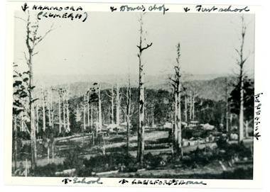
Photograph
... in 1913 from an area known as Point Clear that shows the buildings... the buildings of early Mt Dandenong before the CRB road went through ...Iconic photograph taken by Edgar Dower on Ridge Road in 1913 from an area known as Point Clear that shows the buildings of early Mt Dandenong before the CRB road went through in the 1920s.Black and white photograph with tall, dead trees in foreground and a view of hills in the distance. Buildings can be seen across the centre of the photograph. There are handwritten annotations around the border with arrows referring to areas in the photograph. Reverse of photograph has handwritten description by John Lundy-Clarke.Front from top left: Namoora (Lumeah), Dower's Shop, First school, Talent's, Langford's house, School. Reverse: 1913 view from O'Halloran's LOT 4, Section 3 on Ridge Road. Showing Lumeah (Namoora) Farndons Road (fence) School, Lowes House?, Falls Road Shop (Dowers) Langford's Falls Road (LOT 9, Section 1) Shed on Colomb's LOT 19, Sect 2 Colomb's House (Fergusons) First school Campbell's Blythes Road Lil Badenhop's P.O. In middle distance - Talent's homestead and sheds.point clear, namoora, lumeah, langford, dower, talent, colomb, ferguson, campbell, farndons road, mt dandenong school -
 Bendigo Historical Society Inc.
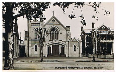
Postcard - ST. ANDREW'S PRESBYTERIAN CHURCH, BENDIGO
... for earlier view of same buildings. On back of photo ' Valentine's... BUILDINGS Church st. andrew's presbyterian church St. Andrew's ...black and white photo: St. Andrew's Presbyterian Church, Myer Street, Bendigo. On RH side of photo, two storey brick building, verandah with cross lattice work. See photo 1637 for earlier view of same buildings. On back of photo ' Valentine's Post Card, a genuine photograph.Valentine's Post Cardbuildings, church, st. andrew's presbyterian church, st. andrew's presbyterian church, bendigo, church -
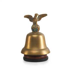 City of Greater Bendigo - Civic Collection
Ceremonial object - Eaglehawk Bell, unknown
... Database notes: "The present building replaced this earlier... Database notes: "The present building replaced this earlier ...The Borough of Eaglehawk was a local government area which covered the northwestern suburbs of the regional city of Bendigo and covered an area of 14.54 square kilometres (5.6 sq mi). Eaglehawk was first incorporated as a borough on 29 July 1862. It had nine councillors, who represented the entire borough. Councillors met at the Town Hall (incorporating the Star Cinema) at the intersection of Sailors Gully Road and Loddon Valley Highway, Eaglehawk. The Town hall has always been the centre of the Borough's activities and was built in 1901 on the site of an earlier town hall which had stood on the location since 1865. The Victorian Heritage Database notes: "The present building replaced this earlier building and was opened on 14 August 1901. The architects were the Melbourne firm of Wilkinson and Permewan. As a much larger and more sumptuous building of brick and stone featuring a central clock tower, the new hall reflected prevailing architectural fashion and was a remarkable investment for a town consisting predominantly of poor mining families. The condition of the town hall is substantially as built. The design is almost identical to the Castlemaine Town Hall." On 7 April 1994, the Borough of Eaglehawk was abolished, and along with the City of Bendigo, the Rural City of Marong and the Shires of Huntly and Strathfieldsaye, was merged into the newly created City of Greater Bendigo.Brass bell with eaglehawk topper / handle on timber stand. The lower front section of the topper has the Borough of Eaglehawk seal attached. No hallmarks or makers stamps visible.borough of eaglehawk, star cinema -
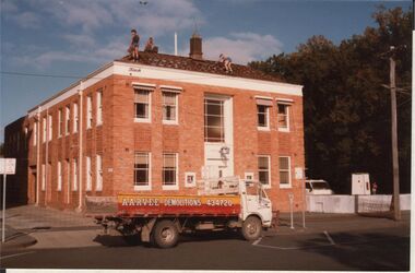 Bendigo Historical Society Inc.
Photograph - POLICE HEADQUARTERS, BULL STREET BENDIGO
... tiles. Building in early stages of demolition.... building, removing tiles. Building in early stages of demolition ...Colour photo: two storey cream brick police headquarters building, tile roof. Situated alongside Court House building in Bull Street, Bendigo. Parked in front of building 'Arvee Demolitions' tray truck. Men on roof of police building, removing tiles. Building in early stages of demolition.organisation, government, police -
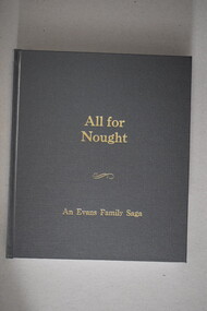 Warrnambool and District Historical Society Inc.
Book, White’s Law Bindery, All for Nought an Evans family saga, 2018
... and builder and was connected with several early road and building... and was connected with several early road and building projects in the mid ...This is a family history of the Evans family.This is a hard cover book of 188 pages. The cover is grey with gold printing on the front and the spine. It has colour and black and white photographs, sketches, maps and illustrations. non-fictionThis is a family history of the Evans family.j.r.evans & family, warrnambool, warrnambool history, john russell evans -
 Surrey Hills Historical Society Collection
Photograph, 111-113 Union Road intersection with Windsor Crescent, 1985
... There are earlier photos of this building both... Road Canterbury melbourne There are earlier photos ...There are earlier photos of this building both in this collection and one on the SLV website. James Sneddon's real estate business was an earlier occupant. Doubleday's occupied the site for nearly 3 decades. Later uses were as a kitchen showroom and a cafe.Colour photo taken on a wet winter's day showing Doubleday Real Estate Agents on the north eastern corner of the intersection. The opposite corner of Windsor Crescent is not visible. Rear in blue biro: "Union Road - Windsor Crescent". Handwriting not recognised. -
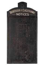 City of Greater Bendigo - Civic Collection
Sign - Borough of Eaglehawk Notices, Borough of Eaglehawk, Unknown
... Database notes: "The present building replaced this earlier... Database notes: "The present building replaced this earlier ...This notice board was used by the Borough of Eaglehawk to inform the community about services and events taking place in the local community and was hung in the Town Hall. Eaglehawk was first incorporated as a borough on 29 July 1862. It had nine councillors, who represented the entire borough. Councillors met at the Town Hall (incorporating the Star Cinema) at the intersection of Sailors Gully Road and Loddon Valley Highway, Eaglehawk. The Town hall has always been the centre of the Borough's activities and was built in 1901 on the site of an earlier town hall which had stood on the location since 1865. The Victorian Heritage Database notes: "The present building replaced this earlier building and was opened on 14 August 1901. The architects were the Melbourne firm of Wilkinson and Permewan. As a much larger and more sumptuous building of brick and stone featuring a central clock tower, the new hall reflected prevailing architectural fashion and was a remarkable investment for a town consisting predominantly of poor mining families. The condition of the town hall is substantially as built. The design is almost identical to the Castlemaine Town Hall." Eaglehawk was a local government area which covered the northwestern suburbs of the regional city of Bendigo and covered an area of 14.54 square kilometres (5.6 sq mi). On 7 April 1994, the Borough of Eaglehawk was abolished, and along with the City of Bendigo, the Rural City of Marong and the Shires of Huntly and Strathfieldsaye, was merged into the newly created City of Greater Bendigo.Handmade wooden notice board. Wood is roughly hewn and painted black with painted silver text. The front of the board is covered in pin holes. borough of eaglehawk -
 Bialik College
Mixed media (series) - Early Learning Centre
... Box containing material relating to the Early Learning...Box containing material relating to the Early Learning ...elc, 1990s, 2000selc, 1990s, 2000s -
 Linton and District Historical Society Inc
Photograph, Sussex Street, Linton - view to north, late 1920s or early 1930s
... Dated to late 1920s or early 1930s as Nelson building has...Dated to late 1920s or early 1930s as Nelson building has ...Dated to late 1920s or early 1930s as Nelson building has been renovated as a Californian bungalow. The earlier curvilinear parapet on the library building (see photo - Registration no. 166) has been squared off, and a small pedimented timber parapet has been added above.Black and white photograph of Linton's main street, Sussex Street. View of Railway Hotel, Nelson undertaker building, public library and "cash emporium". Cars parked and driving along Sussex St."Linton Main Street".sussex street linton, railway hotel, nelson undertakers, linton public library, cash emporium, transport, cars -
 City of Greater Bendigo - Civic Collection
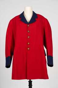
Uniform - Postal Workers Uniform, c. 1890
... location from 1887 until 1997. Early on the building housed... location from 1887 until 1997. Early on the building housed ...The post office was situated on site at this Pall Mall location from 1887 until 1997. Early on the building housed a variety of government services included sub treasury, police, water, lands, post and telegraph and quarters for the resident postmaster. With federation in 1901 the building became the Commonwealth Postmaster - General's Department's Bendigo Post Office. In 1975 postal services were taken over by the Australian Postal Commission and in 1989 Australia Post was corporatised.Colonial era postal uniform possibly worn by the Post Master at the Bendigo Post Office. Single breasted frock coat. Scarlet jacket with contrasting royal blue collar, lapel cuffs and pocket flap. Body and skirt section lined with lighter red cotton fabric, pockets lined with cream coloured cotton fabric, sleeves lined with brown, blue and white striped cotton fabric. Five brass buttons on front, two brass buttons on the top of the centre back pleat, each button with a crown and VR. Typically of frock coats of the 19th century the coat has a two distinct sections, a top jacket and skirt. The shoulder seam is bias cut and runs at an angle down the back. The back is cut in four sections and the skirt in two sections. There are no side seams in the coat, instead there is a seam placed further back than the actual side of the wearer.Any possible text on the label on inner top of collar has disappeared.australia post, city of bendigo post office, city of greater bendigo commerce -
 Uniting Church Archives - Synod of Victoria
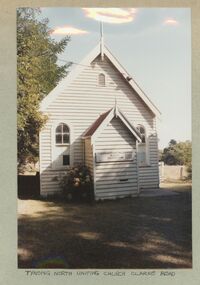
Photograph, 1986
... Shires as a major and early public building in both districts... to the Cardinia and Casey Shires as a major and early public building ...Tynong North former Methodist Church, originally known as Christ Church, Berwick, has been an important community meeting place from c1870 and is significant to the Cardinia and Casey Shires as a major and early public building in both districts. The church may be the oldest (in part) public building in Cardinia Shire. This is a simple gabled church, clad with weatherboards and roofed with corrugated iron. It has a gabled porch with finial and distinctive arched openings (windows and doors) which may be indicative of its reputed early date (c1870), as linked with its classical styling. The windows have multi-paned glazing and the roof gable retains its finial. The concrete stumps and lack of mature planting around the church confirm that it has been moved to the site and restumped. Ref: https://vhd.heritagecouncil.vic.gov.au/places/30143/download-reportColour exterior view of the Tynong North Uniting Church, Clarke Rd. Tynong. The image shows a timber church with a porch.tynong north uniting church