Showing 212 items
matching eastern view
-
 Eltham District Historical Society Inc
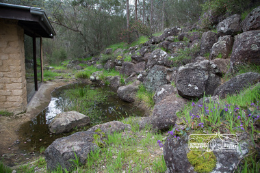
Photograph, Peter Pidgeon, Heritage Excursion; Laughing Waters, Laughing Waters Road, Eltham, 7 Sep 2013, 7 Sep 2013
LAUGHING WATERS WALK This excursion was a follow up to the Laughing Waters Story told to us by Jane Woollard at our Annual General Meeting in March 2013. It involved a walk commencing from the corner of Laughing Waters and Overbank Roads along Laughing Waters Road to its eastern end and returning partly over the same route - a total distance of about 2.5km. On the way we visited the two artist in residence properties to view the houses on them that are associated with Alistair Knox, Gordon Ford and others in the local mud brick and artistic community. An unexpected afternoon tea was offered to us by the artists in residence and we had a brief opportunity to view inside one of the houses.Born Digitalactivities, eltham district historical society, heritage excursion, laughing waters road, eltham -
 Eltham District Historical Society Inc
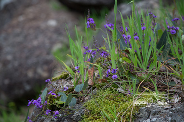
Photograph, Peter Pidgeon, Heritage Excursion; Laughing Waters, Laughing Waters Road, Eltham, 7 Sep 2013, 7 Sep 2013
LAUGHING WATERS WALK This excursion was a follow up to the Laughing Waters Story told to us by Jane Woollard at our Annual General Meeting in March 2013. It involved a walk commencing from the corner of Laughing Waters and Overbank Roads along Laughing Waters Road to its eastern end and returning partly over the same route - a total distance of about 2.5km. On the way we visited the two artist in residence properties to view the houses on them that are associated with Alistair Knox, Gordon Ford and others in the local mud brick and artistic community. An unexpected afternoon tea was offered to us by the artists in residence and we had a brief opportunity to view inside one of the houses.Born Digitalactivities, eltham district historical society, heritage excursion, laughing waters road, eltham -
 Eltham District Historical Society Inc
Photograph, Peter Pidgeon, Heritage Excursion; Laughing Waters, Laughing Waters Road, Eltham, 7 Sep 2013, 7 Sep 2013
LAUGHING WATERS WALK This excursion was a follow up to the Laughing Waters Story told to us by Jane Woollard at our Annual General Meeting in March 2013. It involved a walk commencing from the corner of Laughing Waters and Overbank Roads along Laughing Waters Road to its eastern end and returning partly over the same route - a total distance of about 2.5km. On the way we visited the two artist in residence properties to view the houses on them that are associated with Alistair Knox, Gordon Ford and others in the local mud brick and artistic community. An unexpected afternoon tea was offered to us by the artists in residence and we had a brief opportunity to view inside one of the houses.Born Digitalactivities, eltham district historical society, heritage excursion, laughing waters road, eltham -
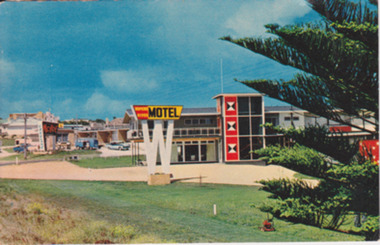 Warrnambool and District Historical Society Inc.
Postcard - Post Card Warrnambool Motels, Circa 1960’s
These two motels were built in the 1960’s on the eastern outskirts of Warrnambool on the corner of the old Princes Highway and Simpson St. They were both built around 1960. The Turn In was originally known as Freeland’s Turn In. The Hopkins River, later the Riverside Motel, was demolished in around 2000. This photograph provides a view of Warrnambool as it was beginning the expansion on the East side of Warrnambool. The buildings depicted are very typical of the style of buildings of the 1960.s Coloured photograph postcard depicting the Hopkins River Motel. Large red and yellow sign mounted on top of a white ‘W’ Part of Norfolk pine. The back is unused. Nucolorvue productions Pty Ltd. W4. Printed in Australia. Printed in Australia. warrnambool, freeland’s turn in, hopkins river motel, turn in motel, warrnambool motels -
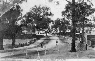 Eltham District Historical Society Inc
Negative - Photograph, Rose Stereograph Company, The Main Strteet, Eltham, Vic, c.1923
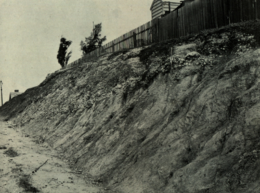
The Rose Series P. 4344 postcard. Similar view to SEPP_0609 taken from near Dudley Street looking north but significantly later in time with numerous stores now constructed on the eastern side south of Pryor Street in what was once Haley's Paddock. Luther Haley sold his bakery store in 1917 and the roof now sports advertising signage for Electrine Candles, presumably coincident with the period of ownership by Hannah Lloyd from 1917 to about February 1920 or Lee’s Railway Store (Messrs J.R. & N.E. Lee 1920-Sep 1922). A boy and a man are standing in the road and the ghost image of three people walking towards them on the footpath just past the store. Ernie Andrew’s combined newsagency and haberdashery/clothing shop with advertising for "The Age" is present at the corner of Arthur Street, on the opposite corner would be the Bootmaker's shop (F. Butterworth, succeeded in 1922 by G.H. McDonald) and William J. Capewell's Butcher shop, second building from right (relocated from in front of the railway station in 1910). North of the News Agency is believed to be Horace H. Clark’s Land and Estate Agency which had also relocated across the road.This photo forms part of a collection of photographs gathered by the Shire of Eltham for their centenary project book,"Pioneers and Painters: 100 years of the Shire of Eltham" by Alan Marshall (1971). The collection of over 500 images is held in partnership between Eltham District Historical Society and Yarra Plenty Regional Library (Eltham Library) and is now formally known as the 'The Shire of Eltham Pioneers Photograph Collection.' It is significant in being the first community sourced collection representing the places and people of the Shire's first one hundred years.Digital image 120 format B&W negative (copy of original postcard)shire of eltham pioneers photograph collection, eltham, main road, bootmakers, butcher, dudley street, electrine candles, eltham town centre, hannah lloyd, lloyd's general store, newsagency, pryor street, rose series postcard, shops, william james capewell, ernie andrew, f. butterworth, g.h. mcdonald, haley's paddock, j.r. lee, lee's railway store, n.e. lee, rose stereograph company -
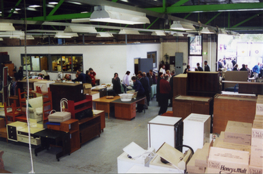
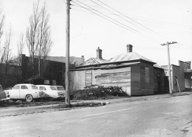 Ringwood and District Historical Society
Photograph, Edwin G. Adamson A.R.P.S, Back grocery, corner Adelaide St Ringwood 1963 (Eastland Litigation Photo) (2 views), May 1963
This series of SS0380 photos are part of the "Eastland Litigation" launched in 1962 by the Whitehorse Traders Co-operative Association (WTCA), against the Ringwood Council's Interim Development Order of 1960. WTCA sought "orders from the Supreme Court of Victoria that the planning scheme was invalid" - See "The Eastland Litigation" chapter in "From Horse Shoes to High Heels - Ringwood Shopping Centre and Eastland 1858-2008" by Richard Carter, Bounce Books 2009.Written on back of photograph 2826-2, 'Back grocery, corner Adelaide St.' Stamped on back, 'Edwin G. Adamson... [and samped] In the Supreme Court 13 Aug 1963'. On back of 2826-1 (similar photo at different time): Photo of the shop and dwelling ordered to be demolished - north-eastern corner of Adelaide St and Maroondah Hwy. -
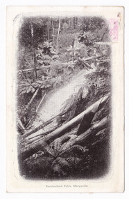 Marysville & District Historical Society
Postcard (item) - Black and white postcard, Nicholas John Caire, Cumberland falls, Marysville, 1858-1918
One of a series of postcards of photographs taken by socialite photographer Nicholas John Caire. N.J. Caire had a great love for the area and in the late 1800's took many photographs of Marysville and its surrounds.One of a series of postcards of photographs taken by socialite photographer Nicholas John Caire. N.J. Caire had a great love for the area in and surrounding Marysville and in the late 1800's took many photographs of Marysville and its surrounds. N.J. Caire was born in 1837 in Guernsey. He arrived in Adelaide about 1860 along with his parents who encouraged his early interest in photography. He opened a studio in Adelaide in 1867 after traveling extensively throughout the Gippsland taking photographs. After marrying in 1870 he moved to Talbot in Victoria until 1876 when he opened a studio in the Royal Arcade in Melbourne. After 1885 N.J. Caire gave up his city work and made his home in South Yarra and devoted the rest of his life to outdoor photography, specializing in the bush, the gullies and the mountains of south-eastern Victoria. Victorian one penny postage stamp Post Card The Address to be written on this side This space may be used for Correspondence/ within the Commonwealth at 1d rate./ Foreign, charged ordinary letter rate. AFFIX STAMP/ HERE Dear Mum/ Will you bring me/ over some/ milk. I cannot/ get any here./ Love to all/ from all/ Hilda Mrs Gregory/ Bay View Hotel/ Frankstonmarysville, victoria, nicholas john caire, postcard, souvenir, cumberland falls -
 Federation University Historical Collection
Book, Report on the Ballarat East Gold-Field, 1894 and Ballarat East Gold-Field, 1907, 1894
The Ballarat Ironworkers' and Polytechnic Association was at the Ballarat School of Mines. In 1907 J.W. Gregory Professor of Geology at Glasgow Univesity, Late Director of the geological Survey of Victoria and Professor of Geology at Melbourne University. W. Dickson was Secretary for Mines and Donald McLeod was the Minister of Mines. in 1894 Ernest Lidgey was the Assistant Geological Surveyor for the Victorian Department of Mines. A.W. Howitt was Secretary for Mines and Henry Foster was the Minister of Mines. Charcoal hard covered report on the Ballarat East Goldfield. The book combines two reports from the Victorian Department of Mines. The 1894 report is 52 pages and includes images and plans. The 1907 Report is number 4 in the Memoirs of the Geological Survey of Victoria. Photographs include Looking South from the Britannia Mullock Heap, View from Sovereign Hill, Golden Point gold discovery site.Stamped "Ballarat Ironworkers' Association School of Mines" Bookplate of the Ballarat Ironworkers' and Polytechnic Association. Written inside front cover: "S.J. Miller, 115 Ascot Street, Ballarat"ballarat ironworkers' and polytechnic association, ballarat school of mines, ironworkers, geology, mining, ballarat east, llanberris, victoria united mine, normanby, north woah hawp, bookplate, s.j. miller, library plate, golden point, gold discovery at golden point, new normanby mine, william baragwanath, new speedwell, britannia united, llanberris co, sulieman pasha, prince regent, dalzell-cum-prince regent, north prince extended, eastern star, f. gray, victoria united gold mine, sovereign hill mine, prince regent mine, britannia mine -
 Yarra Glen & District Historical Society
Black and white photographs, Bell Street Yarra Glen looking north c.1900
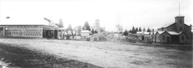
View of Bell Street Yarra Glen looking north from junction with King Street. On left hand side is Scott & Allen's General Store, next to that is a bootmaker, then the house of Charles Bath, the Grand Hotel and the Colonial Bank building. On the eastern side of Bell Street (right hand side of photograph) is the Victoria Hall. Beyond that is W.J.Dawborn's General Store, then Smith's bakery, and on top of the hill the trees surrounding 'Point Pleasant' owned by the Herbert family.yarra glen, point pleasant, grand hotel, victoria hall, bell street, charles bath, general store, colonial bank, bank building, w j dawborn, scott and allen, bootmaker, smith, bakery, baker s shop, herbert -
 Federation University Historical Collection
Photograph, Marilyn Jeffs, Hotels of Ballarat, 2019
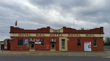
Numerous photographs take by Marilyn Jeffs for use on the Ballarat and District Industrial Heritage Wikihotels, ballarat, royal mail hotel, peter lalor hotel, the george hotel, x on albert hotel, cattleyards inn, market hotel, bunch of grapes hotel, argyle hotel, atlantic hotel, ballarat hotel, black hill hotel, blue bell hotel, bluebell hotel, brown hill hotel, canberra hotel, carboni, carboni's italian kitchen, eureka stockade hotel, carriers arms hotel, eastern station hotel, centenary hotel, craig's hotel, eastern railway hotel, freight bar, athletic club hotel, grapes hotel, munster arms hotel, golden city hotel, golf house hotel, irish murphy's, camp hotel, lake view hotel, la porchetta, southern cross hotel, the mallow hotel, meaghers hotel, millers arms, miners tavern hotel, miner's tavern hotel, provincial hotel, north britain hotel, north star hotel, oscar's hotel, criterian hotel, park hotel, prince regent house, prince regent hotel, sport globe, sporting globe, jacksons hotel, railway hotel, pwtn, pater lalor hotel, royal highlander hotel, queen's head hotel, red lion hotel, robin hood hotel, military arms hotel, royal oak hotel, western hotel, imperial hotel, unicorn hotel, union hotel -
 Ringwood and District Historical Society
Film, Eastern Newsbeat (Channel 31/44) videos of Ringwood State School Celebration on 12 Nov 2022
Recorded on DVDsFile 1 - Eastern Newsbeat segments (3) and Scottish Dancers File 2 - Interview with Russ Haines, President of Ringwood & District Historical Society File 3 - Interview with Peter Fry, Treasurer of Ringwood & District Historical Society, ex-RSS pupil File 4 - Interview with Gerry Robinson, Convenor, Heathmont History Group File 5 - Interview with Thomas Guest, ex-pupil RSS and 3 copies of the extended version of the Eastern Newsbeat program Producer/Director/Host Tricia Ziemer, www.youtube.com/tmztvaustralia Interviews also done with Russ Read of ECB/FM local radio station (To arrange viewing of Ringwood State School Centenary videos, contact Ringwood and District Historical Society) -
 City of Moorabbin Historical Society (Operating the Box Cottage Museum)
Newsletter, City of Moorabbin Historical Society No. 7 Vol. 6 August 1966, City of Moorabbin Historical Society No. 7 Vol.6 August 1966, 1966
Topic ; South-Eastern Historical Association 5/6/1966; mrs H Biehl letter of grandfather 1845 ; Harry Hawker Memorial; changing times and words. The Aims of the CMHS are ‘to record the history of the City, and register something of the Australian Atmosphere, which the necessary speed-up in post-world-war two (WW11) immigration has caused to be lost; to produce a magazine at regular intervals, featuring the work of pioneers and the changing Australian scene; to work constantly with a long range view towards building a hall where records and exhibits can be housed’ (1961) The Original Newsletters reflect the history and heritage of the former City of Moorabbin — derived from Mooroobin, ‘a resting place’ in the Bunurrung spoken language. In 1994, the City of Moorabbin was integrated into the Cities of Bayside, Glen Eira, Kingston and Monash This is Newsletter No. 7 Vol. 6 of the CMHS August 1966 CMHS obtained a Kingston City Council Community Grant 2016 for the digitization and preservation of these Original CMHS Newsletters commenced in 1961 2 x L 26cm x W 21cm page 1 printed both sides CITY OF MOORABBIN HISTORICAL SOCIETY/ AFFILIATED WITH THE ROYAL HISTORICAL SOCIETY OF / VICTORIA WITH THE CHELTENHAM ARTS AND CRAFTS SOCIETY/ President Mrs N. Blackman ...... Secretary Mrs F. Neville...../ VOLUME 6 No.7 NEWSLETTER AUGUST 1966 / ........city of moorabbin historical society 1961, sheehy t.a., newsletters -
Port Melbourne Historical & Preservation Society
Photograph - Missions to Seamen, Port Melbourne, Alison Kelly, 1990
Photographed by Alison Kelly while she was joint caretaker of the building during the Mission Arts Centre days 1987 to 1991From album of photos mostly by Alison Kelly: Missions to Seamen building, view from Beach Road and Swallow Street to eastern side of chapel; bottle brush plants in foregroundmissions to seamen, built environment, alison kelly -
 Port Melbourne Historical & Preservation Society
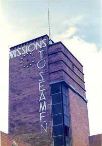
Photograph - ClokTower Soth and east. Missions to Seamen, Port Melbourne, Alison Kelly, 1990
Photographed by Alison Kelly while she was joint caretaker of the building during the Mission Arts Centre days 1987 to 1991 Port Melbourne Missions to Seamen building, colour view of clocktower, southern and eastern faces - window pane missing. From album of photos mostly by Alison Kelly:missions to seamen, built environment -
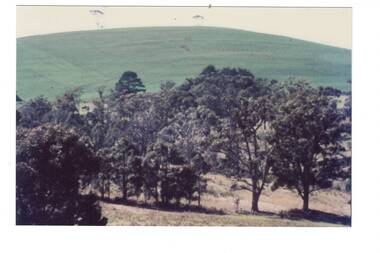 Buninyong & District Historical Society
Photograph - Photograph colour of Green Hill, View of Green Hill from Ballarat Institute of Advanced Education (Federation University) site, 1968
Colour photograph of site of Ballarat Institute of Advanced Education 1968 showing Green HillThe construction of the Mt. Helen campus in the 1970s in the predominately rural area was an important milestone in the expansion of tertiary education in the Central HighlandsColour photograph from Ballarat Institute of Advanced Education construction site toward Green Hill 1968Mt. Helen Site - Eastern end towards Green Hill 1968education, ballarat institute of advanced education, federation university, landscape, mt. helen, green hill -
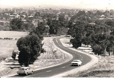 Hume City Civic Collection
Photograph, Early 1970s
... A black and white panoramic view of the eastern approach... panoramic view of the eastern approach to Sunbury and the Sunbury ...In the early 1970s the eastern approach to Sunbury was changed. The stone bridge spanning the Jacksons Creek was replaced by a wider concrete structure and dangerous curves were taken out of the road. The area on the LHS of the photograph including the two arched stone bridge has been incorporated into a public picnic area.A black and white panoramic view of the eastern approach to Sunbury and the Sunbury township before the road was widened and straightened and the new bridge was built. There are two cars in the foreground. One is approaching the bridge and the other is leaving Sunbury.macedon street, macedon street road bridge, jacksons creek, sunbury township, george evans collection -
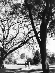 University of Melbourne, Burnley Campus Archives
Photograph - Black and white print, Peter Esdale, The Oak Lawn and Main Building, 1990-1991
5 copies black and white photograph, one an enlargement taken by P. Esdale. View taken from Oak Lawn towards the Administration Building with a back view of 2 people walking along the path. All the same but with different descriptions on their reverses.On reverse of (a), "The Main Building VCAH Burnley 1990. Photo courtesy of P. Esdale," and on reverse of (b), "The oak lawn and Main Building. Peter Esdale 1990." (c) On reverse, "Main Building VCAH Burnley 1991 Eastern Aspect."1990., administration building, oak lawn, students, main building, trees, garden view -
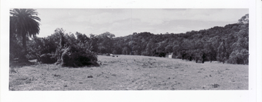
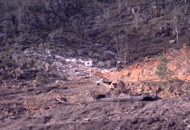 Stawell Historical Society Inc
Slide, View of the Eastern side of Lake Bellfield during construction
... View of the Eastern side of Lake Bellfield during...Colour Slide: View of the eastern side of Lake Bellfied... grampians Lake Bellfied during Construction Colour Slide: View ...Lake Bellfied during ConstructionColour Slide: View of the eastern side of Lake Bellfied during construction showing an Sign with a solid red cirlce on a white Squre background. -
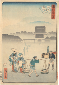 Latrobe Regional Gallery
Print, HIROSHIGE II, Morning Mist at Zojo Temple from the series '36 Views of the Eastern Capital', 1861
... Mist at Zojo Temple from the series '36 Views of the Eastern ...Edo PeriodColoured woodblock printzojo temple -
Koorie Heritage Trust
Book, Department of Pacific and Southeast Asian History, Australian National University, Aboriginal History - Volume 08. 1-2 1984, 1984
This volume of 'Australian History' is devoted to studies of the south-eastern corner of the Australian continent. The papers arose from a series of meetings convened with Professer R. W. Dixon in 1981. They involved scholars from the disciplines listed, all concerned with the south-east. A series of articles by leading writers on Aboriginal History.237 P.; ill,; figs.; tables; notes; reviews; 24 cm.This volume of 'Australian History' is devoted to studies of the south-eastern corner of the Australian continent. The papers arose from a series of meetings convened with Professer R. W. Dixon in 1981. They involved scholars from the disciplines listed, all concerned with the south-east. A series of articles by leading writers on Aboriginal History.aboriginal australians -- periodicals. | ethnology -- australia -- periodicals. | settlement and contacts - colonisation - 1788-1850 | race relations - violent - massacres, murders, poisonings etc. - to 1900 | sex relations | indigenous knowledge - world view | language - personal names | language - semantics | social identity | language - sociolinguistics | government policy - state and territory - new south wales | socioeconomic conditions - living conditions | language - linguistics - language classification | language - vocabulary - word lists | language - linguistics | geography - territories and boundaries | art - rock art - painting | art - production - materials / techniques | art - art motifs | -
 Whitehorse Historical Society Inc.
Photograph, Original Site of Schwerkolt Home, 14/02/2001 12:00:00 AM
Photographed by Ted Goode to record the topography of site. Proposed Eastern Freeway Extension will cut through the treed area.Three copies of the view of original site of Schwerkolt home - now horse paddock adjoining Cottage Reserve.schwerkolt family, schwerkolt, original cottage site., goode, ted, horse paddock -
 Whitehorse Historical Society Inc.
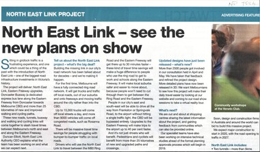
Article, North East Link Plan, 2018
Plans for the North East Link project can be viewed at northeastlink.vic.gov.auPlans for the North East Link project can be viewed at northeastlink.vic.gov.auPlans for the North East Link project can be viewed at northeastlink.vic.gov.aunorth east link, eastern freeway, bicycle paths -
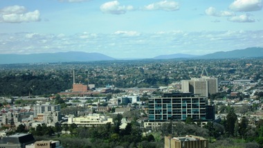 Ballarat Heritage Services
Digital photographs, L.J. Gervasoni, View East from 1 Spring St Melbourne, c2017
Digital imagescityscape, landscape, eastern suburbs, fitzroy gardens, melbourne, carlton united breweries -
 Whitehorse Historical Society Inc.
Photograph, Eastern Emergency Relief Network
... of the opening of the Eastern Emergency Relief Network, 10-12 Thornton ...The Nunawading Ladies Benevolent Society became the Whitehorse Emergency Relief Network in 1999 when a number of community organizations were encouraged to form a network by Betty and Keith Rooney. The object is to collect domestic items of good quality to assist people in need, especially women who have been the victims of domestic violence.Coloured photograph of the opening of the Eastern Emergency Relief Network, 10-12 Thornton Crescent, Mitcham on April 13 1999. Photograph shows people viewing donated goods.whitehorse emergency relief network, mitcham, thornton crescent no 10-12 -
 City of Ballarat Libraries
Photograph, View of Lake Wendouree from Fry's Mill circa 1890s
This view from Fry's Mill is of the eastern side of the lake.lake wendouree, fry's mill, ballarat -
Lakes Entrance Historical Society
Photograph, 1992
Date made December 1992Colour photograph close up view of the suction pump from the dredge Paynesville sitting on Eastern Wharf, clearly shows the name of maker Ruston Lincoln England. Lakes Entrance Victoriadredging, waterways -
 Ballarat and District Irish Association
Photograph - Colour, Clare Gervasoni, Crossley near 'Hillside" McCartney's Lane, 2014, 04/04/2014
Before 1941 "Hillside", McCartney's Road was associated with the Carroll Family. Patrick Edmund Carroll, his wife Mary Matilda Fitzgerald, and children Kathleen, Ronald and Rosemary were the last members of the family to live at and work "Hillside". Stanislaus Kelly and his wife Margaret (nee Gorman) bought the farm from the Carroll family. The couple raised six children on the land: May, Mary, Leo, Ray (Lofty), Daniel (Tich) and Bernadette. The family grew spuds and onions on the hill and milked cows, with the little dairy located on the eastern side of the house. (information from Mary Kelly)Colour digital photographs of Crossley, Victoria, near McCartney's Lane. The house depicted is "Hillside" in McCartney's Lane. The views towards an extinct volcano is Tower Hill.crossley, hillside, carroll, tower hill, mccartney's lane -
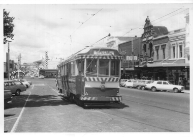 Ballarat Tramway Museum
Photograph - Black and White - tram 40 in the City Loop, A T Miles, Nov. 1969
Black and White - tram 40 in the City Loop at the eastern end of Sturt St. Trams were parked in the loop during the day between peak periods rather than run them back to the depot. Taken by A T Miles Nov. 1969.Yields information about the Ballarat Tramway operations and views during 1969.Photograph - black and white print with notes on rear.A T Miles stamp and location and date notes.tramways, trams, sturt st, city loop, tram 40 -
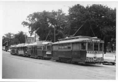 Ballarat Tramway Museum
Photograph - Black and White - four trams in the City Loop, A T Miles, Nov. 1969
Black and White - four trams in the City Loop at the eastern end of Sturt St, including tram 33 and the Santa Tram. Trams were parked in the loop during the day between peak periods rather than run them back to the depot. Taken by A T Miles Nov. 1969.Yields information about the Ballarat Tramway operations and views during 1969.Photograph - black and white print with notes on rear.A T Miles stamp and location and date notes.tramways, trams, sturt st, city loop, tram 33, santa tram